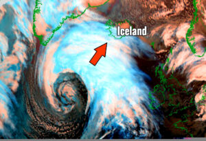
A remarkable near-record wind gusts reported at Hafnarfjall station, Iceland today – 255 km/h!

The intense windstorm over Iceland has resulted in extremely severe winds in some areas, especially where downslope winds have contributed to violent gusts exceeding 200 … Read more

UPDATE on the extremely deep cyclone nearing Iceland – a *violent* windstorm is underway!

Latest satellite imagery and weather station data across Iceland indicate the extremely severe winds are fully developed across the North Atlantic. The mature stage of … Read more

Day after tomorrow? No, but we are facing two impressive extra-tropical cyclones right now – one over the North Pacific and another over the North Atlantic

Remember the famous movie ‘The day after tomorrow’? It obviously did not get into reality, but the satellite images today across the northern hemisphere are … Read more

Planning Valentine’s day trip to Iceland? Not this year! A *violent* windstorm with wind gusts locally 180-220 km/h is expected tomorrow, Feb 14th

Seriously, although many are impressed by the exceptional satellite presentation of the ongoing explosive cyclogenesis over the North Atlantic (or the deep extra-tropical cyclone over … Read more

North Atlantic *update* – Impressive satellite presentation of twin cyclones

Here is a short morning update on the very dynamic pattern over the North Atlantic today; we have a decaying deep cyclone, passing over the … Read more

Explosive cyclogenesis underway across the Northwest Atlantic, while the system is creating tandem of twins – it is connected to the cyclone nearing the UK and Ireland

As expected, the Northwest and North Atlantic are creating a spectacular show tonight. A very impressive satellite presentation is seen on the explosive cyclogenesis near … Read more