The new November forecast data for Winter 2026/2027 shows another step toward a colder and snowier pattern across a large part of the United States, while Europe stays mild. And with the strongest Super El Niño in decades approaching its peak, the forecast now has only one close match among past Super El Niño winters: 1997/1998.
That winter was very mild across the north, yet it still delivered well above-normal snowfall in several regions. Below, I look at what changed in the November data for the United States, Canada, and Europe, how closely this winter follows past Super El Niño events, and a looming Polar Vortex disruption that two major models now show for mid-winter. You can also check your own state, province, or country in the updated Winter Forecast Explorer.
What Changed in the November Forecast: Going Colder and Snowier
Beyond the forecast itself, I am always interested in how forecasts change month to month. This tells us a lot about which direction the forecasts are trending. Below is the difference between the latest and previous forecast, showing how the trend has evolved in the latest forecast for the December-March period.
Looking at pressure changes first, you can see that the latest forecast has really intensified the low-pressure zone in the Atlantic, over the United States, and amplified the high-pressure zone over Canada. Just to make it clear, this is not the actual forecast pattern, but just the change between the previous and latest forecast. The trend makes another step towards an amplified winter pattern over the United States.
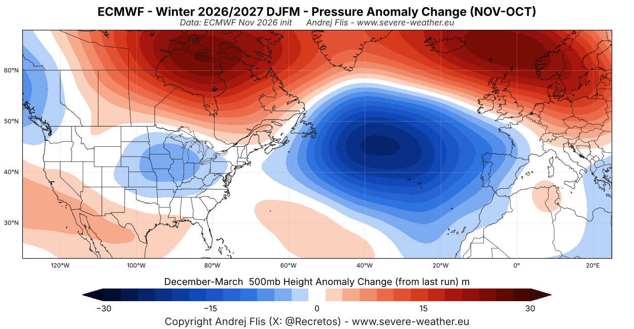
Over Europe, we can see a strengthening of the high-pressure anomaly. Combined with a deeper low-pressure area in the Atlantic, this enables a milder westerly to southerly flow across the continent.
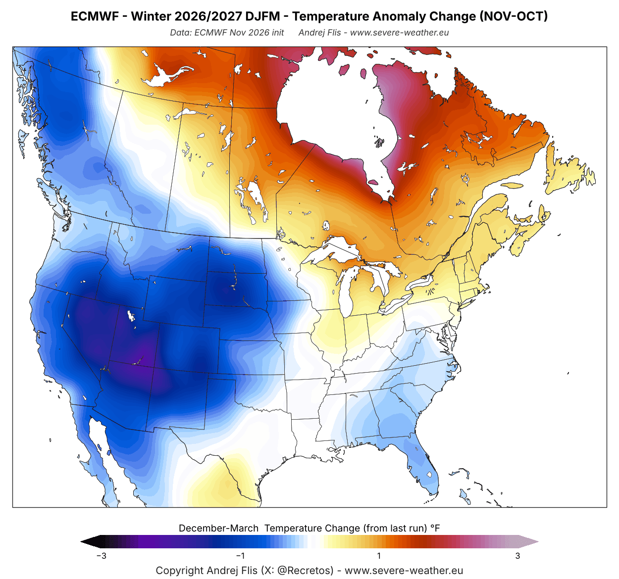
The temperature trend responds directly to the pressure changes, creating a colder shift across the western United States and the Southeast. This follows the pressure drop over the central United States seen above, which brings a more northerly flow on its western side. A warmer anomaly trend continues for the upper Midwest, the Northeast, and Canada.
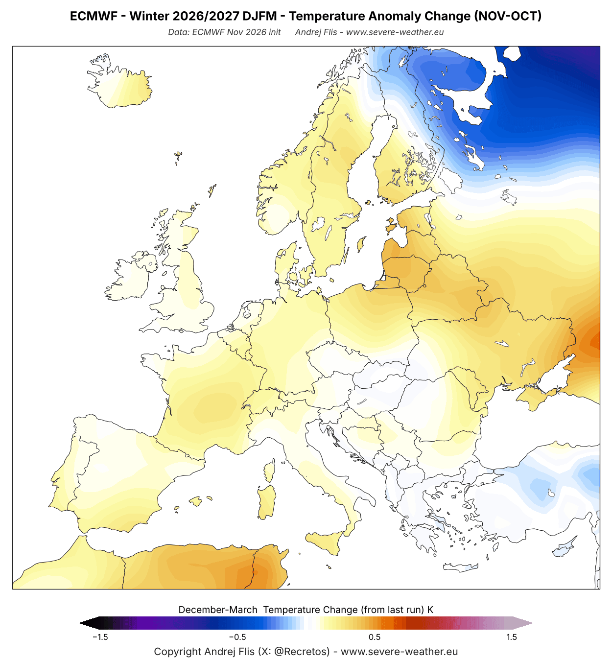
As the pressure changes suggest, Europe shows warmer temperatures in this run than last month. But the temperature increase is not as big as expected, given the pressure changes in the Atlantic.
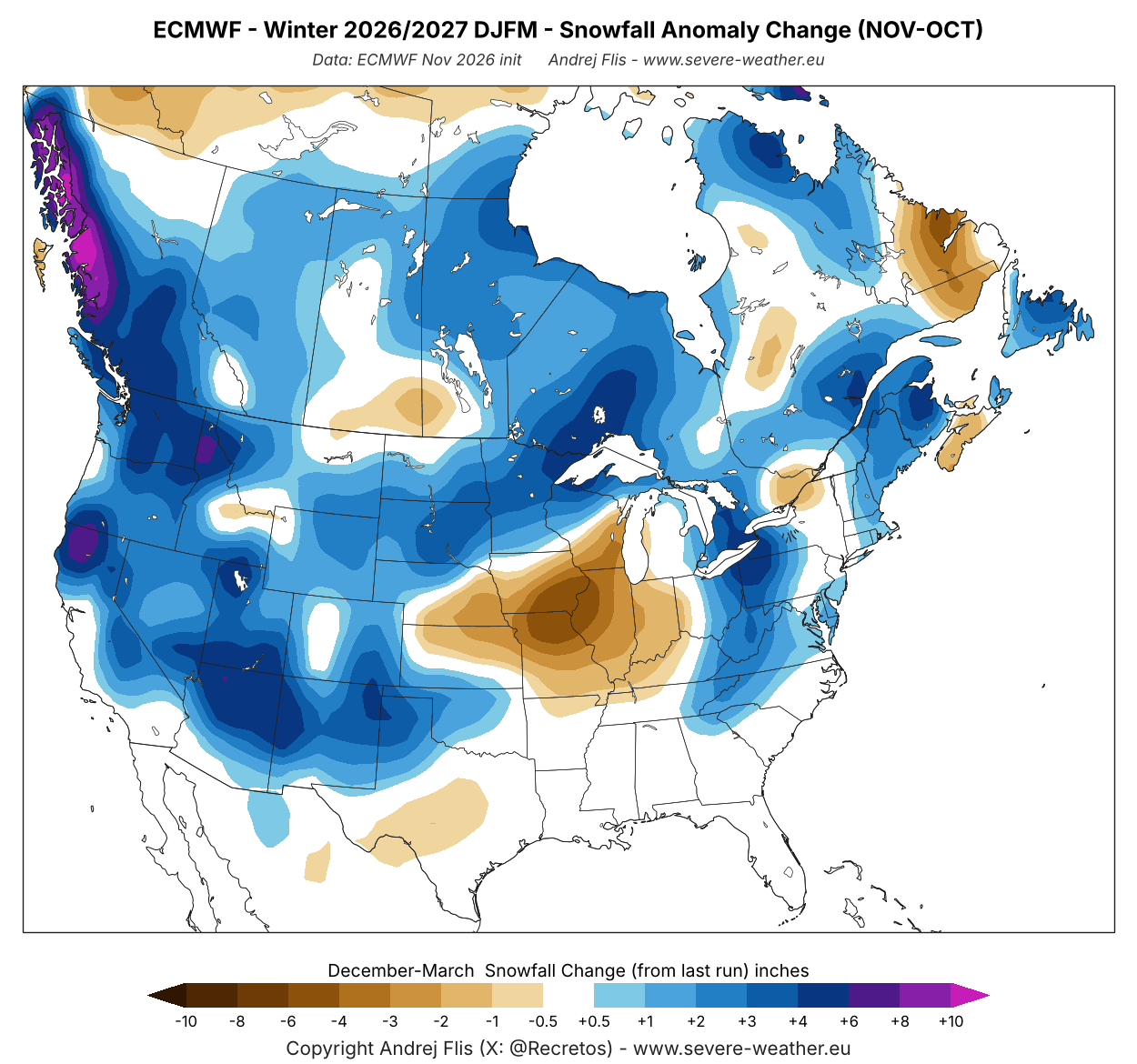
A notable change is also another snowfall increase across a large part of the United States and southern Canada. The latest forecast shows more snow than the last run over much of the western and northern United States, over the Appalachians and the far northeast, and southern Canada. The exception is the central Midwest, where this run shows less snow than the last one.
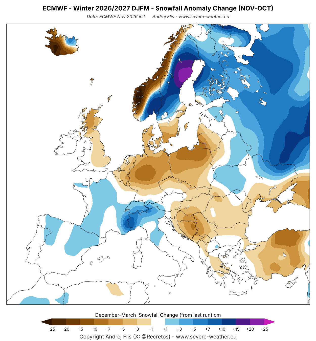
Europe shows a small increase in snowfall over the west-central parts and a larger one towards the northeast, but less over the central and southeastern parts.
Overall, the latest forecast shows an interesting shift, which still remains in the Super El Niño pattern, especially over the United States and Canada. But it reflects movements of the main pressure systems west or east, allowing a change in the weather outcome.
We will quickly look at the latest Super El Niño state and which past Super El Niño event comes closest to the Winter 2026/2027 forecast.
Super El Niño 2026/2027: Which Past Winter Is the Closest Match
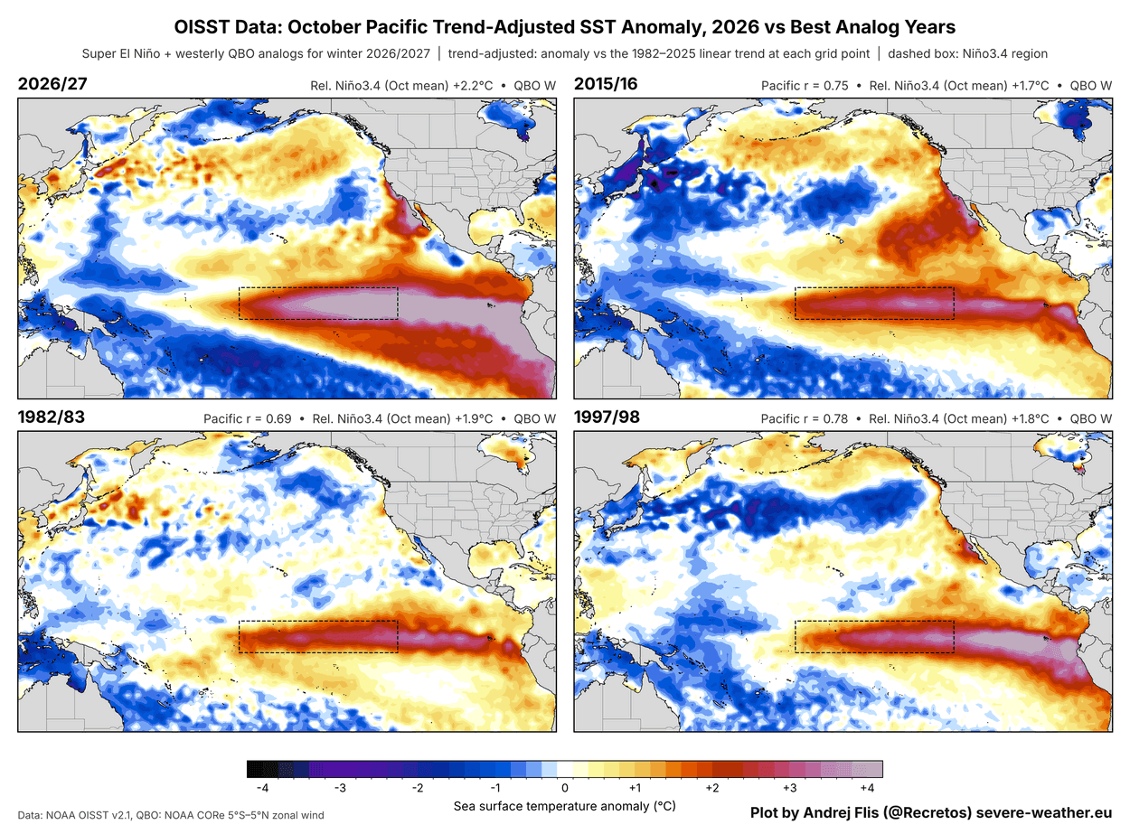
Below is my latest El Niño analysis, created from NOAA OISST data. It compares this October’s ocean anomalies with the three previous Super El Niño events, using the same scale and normalization. You can see how much stronger the 2026 event is, with only the 1997/1998 event coming close in the overall anomaly pattern.
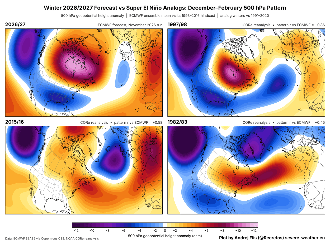
I also decided to compare the December-February pressure pattern between all these Super El Niño events, but using the forecast data for 2026/2027. What we can see is that 1997/1998 is also the only close match to the predicted pattern for 2026/2027. It doesn’t mean that we will see a 97/98 repeat, but it can be a clue.
The image below shows the temperature and snowfall anomalies for 97/98, one of the strongest El Niño events on record. Temperatures show a large area of warmer-than-normal temperatures across southern Canada and the northern half of the United States. The warmest anomalies were over the Upper Midwest and the northern Plains, while the Southwest was colder than normal.
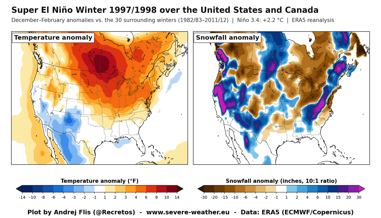
But the snowfall analysis shows an interesting picture. There was less snowfall across the northern Plains, the Midwest, the Great Lakes, and over eastern Canada. The active southern storm track brought well above-normal snowfall to the Sierra Nevada, the mountains of the Southwest, the Appalachians, and into the Northeast.
This means that even a very mild Super El Niño winter can still deliver a lot of snow, depending on the position of the main pressure systems and how much cold air is available.
The same winter in Europe shows a very different story. The season was milder than normal across most of the continent, with the strongest anomalies over the central parts. The only really cold area was the far north and northeast.
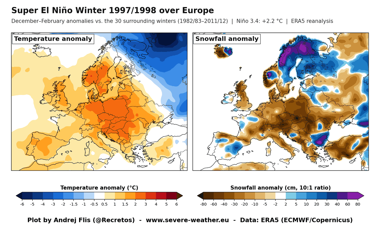
The snowfall analysis shows a broad deficit across central Europe, the UK, and into the southeast, as the mild westerly flow brought more rain than snow at lower elevations. More snowfall was mostly limited to the far north, with a few smaller areas over higher terrain in the southwest and southeast.
We have to keep in mind that this is just one winter example, and it does not mean the same outcome in every Super El Niño event. So it’s time we look at what the actual latest forecast shows for Winter 2026/2027.
Winter 2026/2027 Forecast Update: A Mild North and a Colder, Stormy South
Forecast maps below cover the meteorological winter months (December, January, and February). I am using the latest (November) run of the ECMWF seasonal model, likely the best long-range system available.
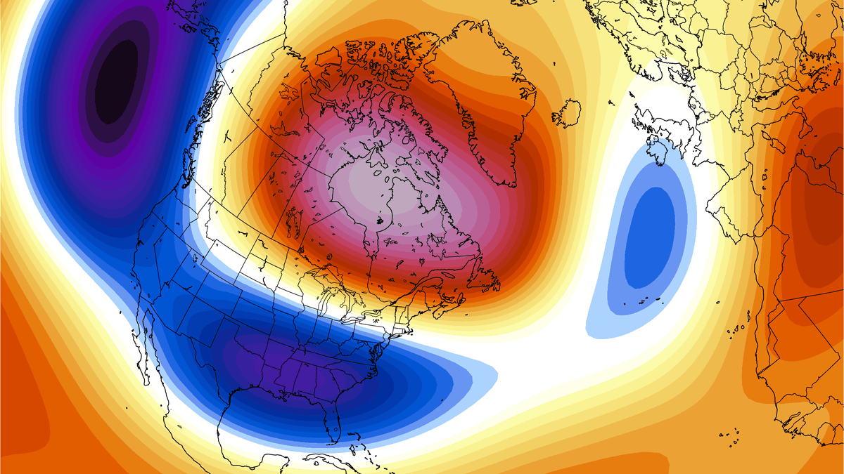
Below is the pressure anomaly forecast, and it has “Super El Niño” written all over it. The main features are a low-pressure zone in the North Pacific and a blocking high-pressure area over Canada, which is a pressure pair that is seen with every major El Niño event. But this time, we also have an amplified low-pressure zone over the southern United States.
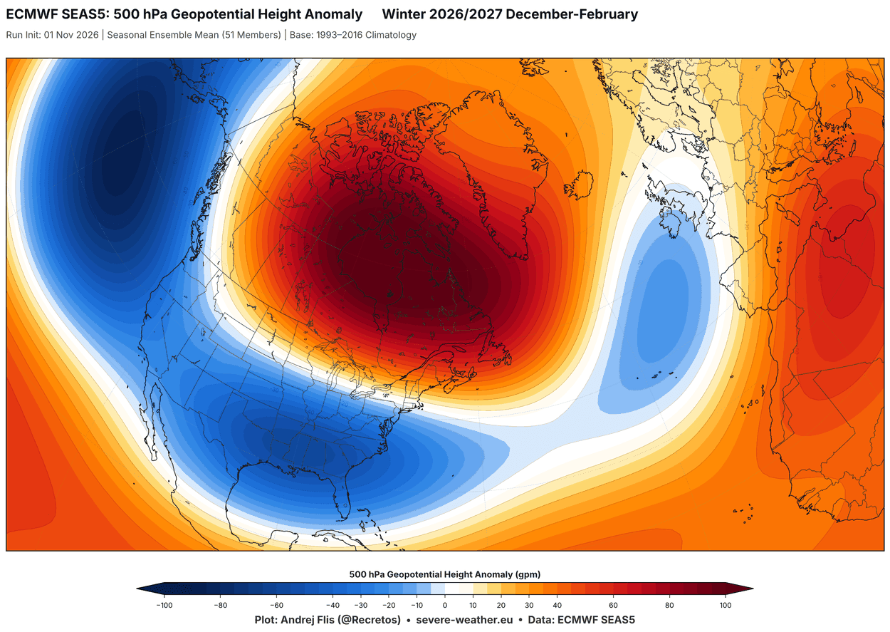
The amplified low-pressure pattern across the southern and eastern United States is driven by a strong Pacific jet stream, another signature of a Super El Niño winter. The low-pressure zone continues into the Atlantic, while high pressure covers most of Europe, creating a mild southwesterly flow between the two pressure zones.
The southern low-pressure zone results in a stronger temperature difference between the United States and Canada. In the temperature forecast below, you can see above-normal temperatures under the high-pressure zone in Canada, the northern United States, and the Northeast.
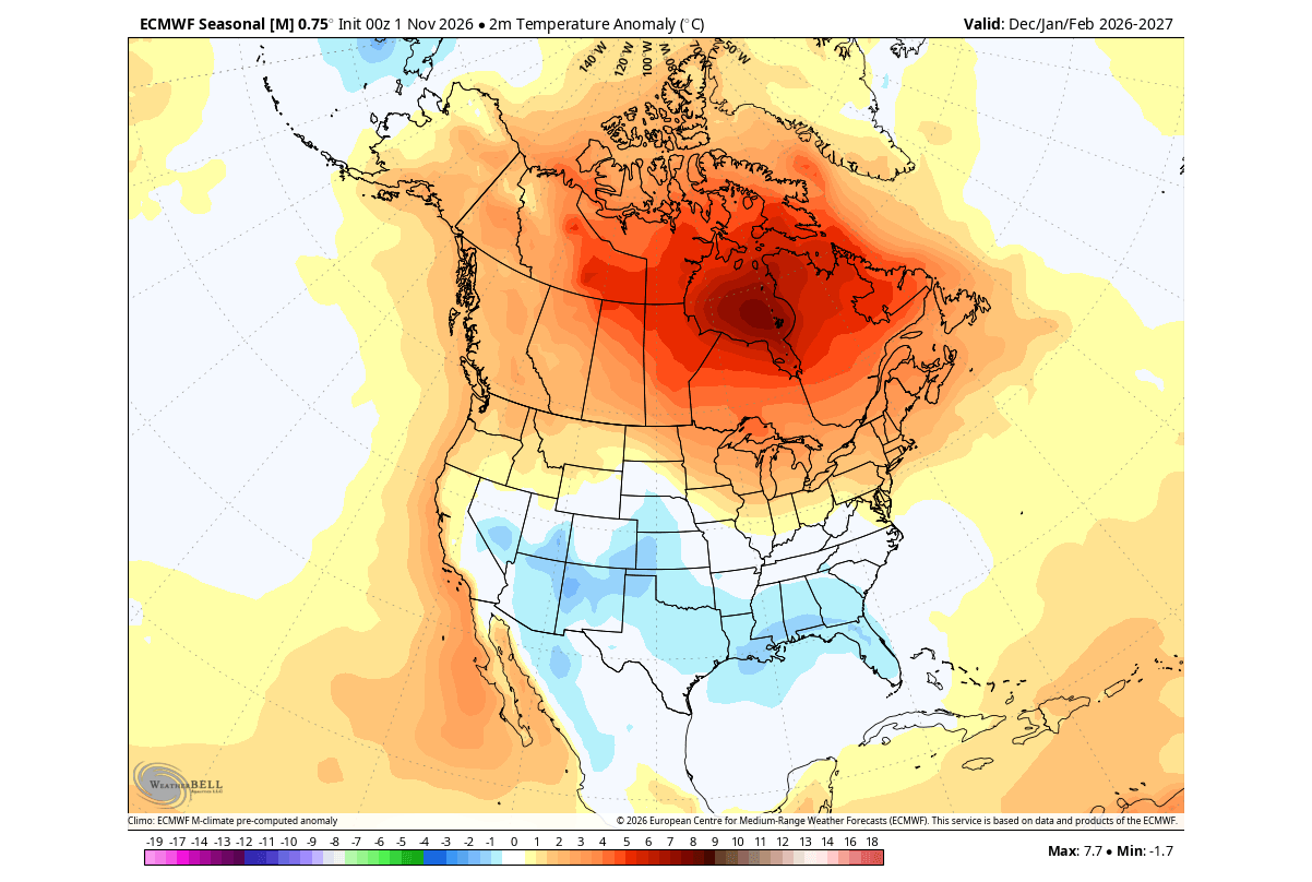
The low-pressure zone over the south creates widespread below-normal temperatures in the latest data across the southern United States, from the Southwest and the south-central Plains into the Southeast. This is due to low-pressure systems bringing persistent cloud cover and unsettled weather.
The precipitation forecast shows a strong Super El Niño signature, with above-normal precipitation over most of the United States. We see amplified precipitation across the Southeast and California, due to an amplified Pacific jet stream, with risk of isolated flooding events.
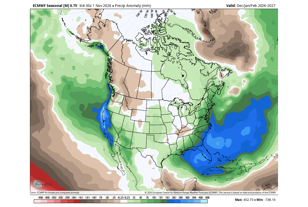
A stronger Pacific jet brings lower pressure and more moisture, creating increased precipitation and snowfall if cold air is available. With a weaker polar jet stream, we see below-normal precipitation forecast for western Canada and parts of the northern United States.
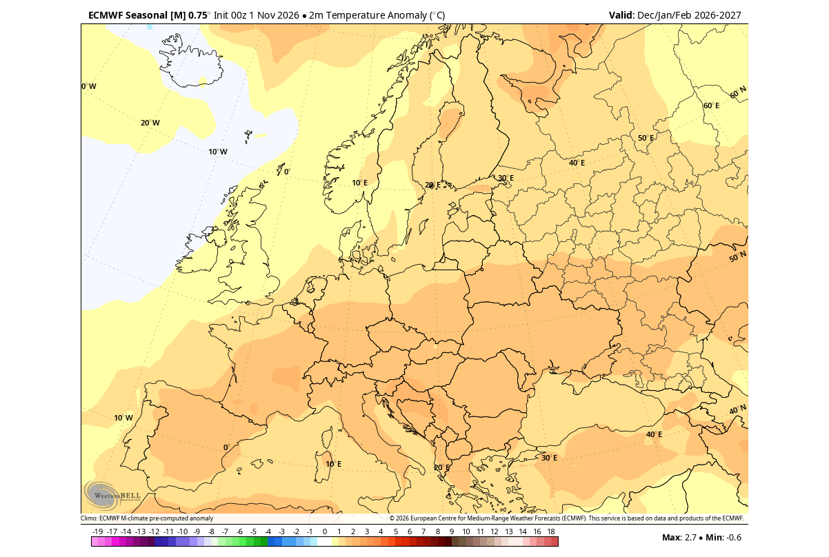
The Super El Niño impact also reaches into Europe, bringing mostly above-normal winter temperatures. This results from a dominant mild westerly flow. This still allows individual northerly flow events, as low-pressure areas move from the Atlantic into northern Europe, pulling down northerly air on their rear side.
The precipitation forecast shows above-normal winter precipitation across much of the continent. This is because westerly and southwesterly flow from the Atlantic brings a large amount of moisture, increasing precipitation potential, more amplified in the western parts.
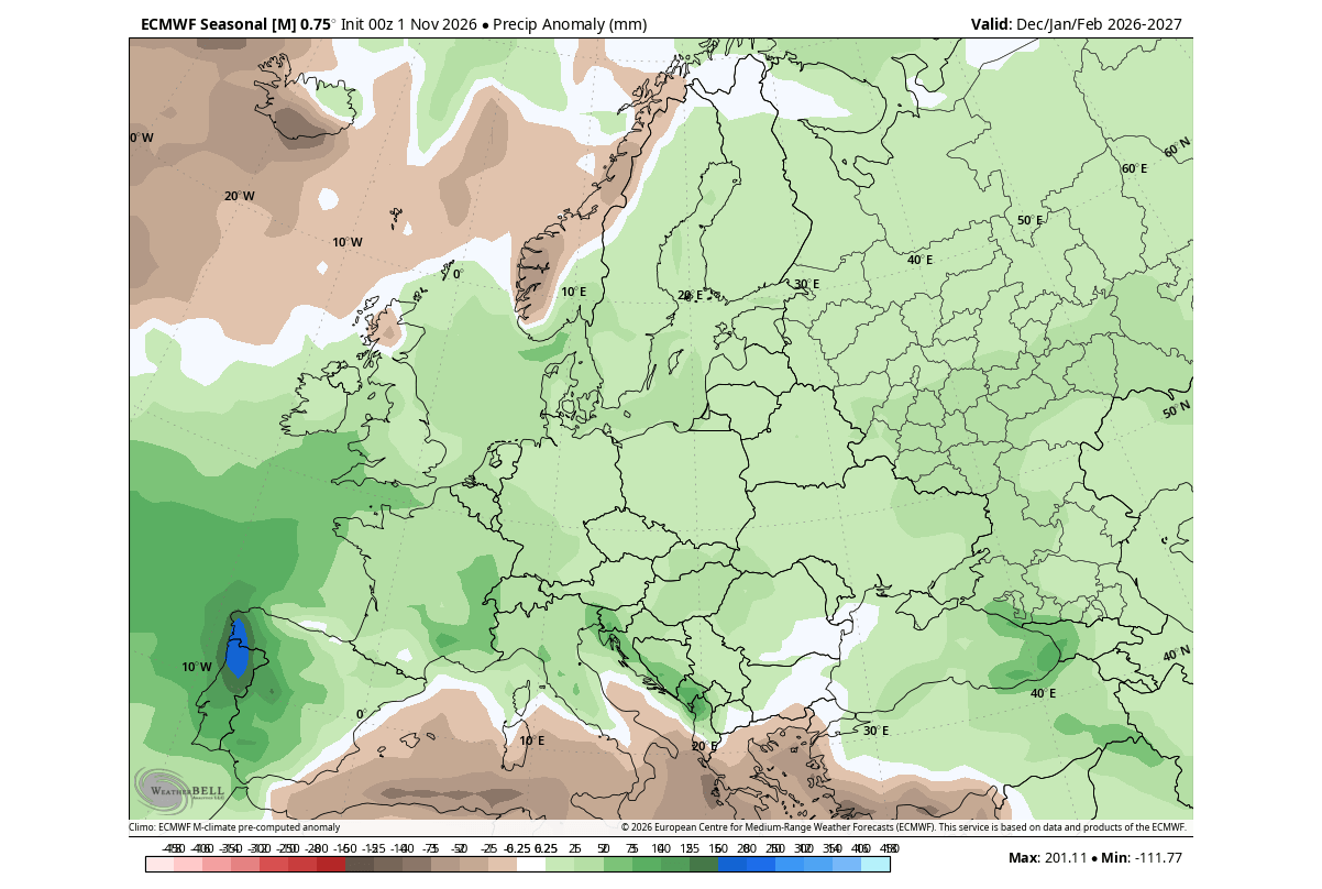
But more winter precipitation does not automatically mean more snow, as it requires a source of cold air, which depends on pressure patterns and also elevation. For this reason, we will look at actual seasonal snowfall forecasts.
Winter 2026/2027 Snowfall: Latest Trends for the United States, Canada and Europe
The Super El Niño also strongly impacts snowfall distribution by changing the positioning of the main pressure systems. With an amplified southern jet stream and potential periods of colder air, we can get surprising snowstorms across the central, southern, and eastern United States.
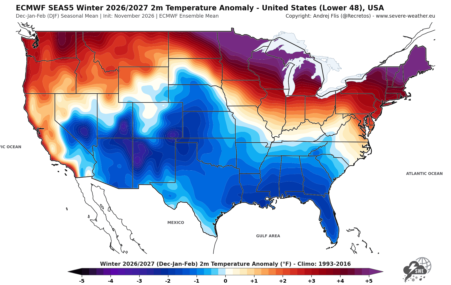
Below is the new ECMWF snowfall forecast, which shows the Super El Niño influence. We have a strong snowfall deficit across the Pacific Northwest, western Canada, the northern Rockies, the Great Lakes, and Maritime Canada. But we also have above-normal snowfall potential across the central, southwestern, and eastern United States.
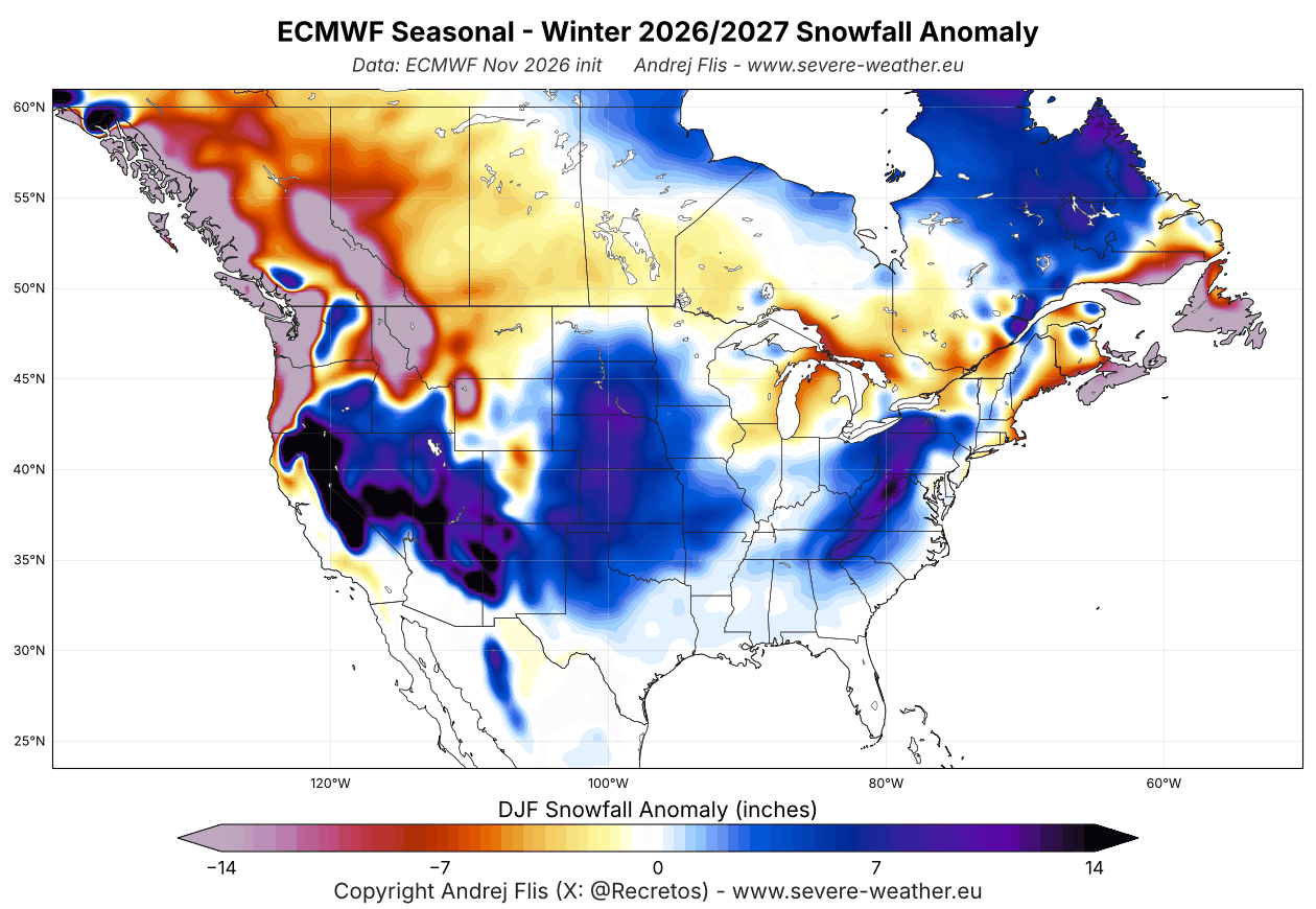
By region, above-normal snowfall is indicated across much of the Southwest, the Plains, parts of the Midwest and Ohio Valley, and the Appalachians into the interior Mid-Atlantic.
For skiers and winter sports enthusiasts, the strongest snowfall signal remains over the Sierra Nevada, California. But above-normal snowfall also extends across the Great Basin, Utah, the Southern Rockies, and the elevations of Arizona and New Mexico.
Over Europe, the overall seasonal pattern is not favorable for broad snowfall, with exceptions in the northern regions and at higher elevations like the Alps. There is enough winter precipitation, but it comes with a milder airmass, pushing the snow line higher than usual.
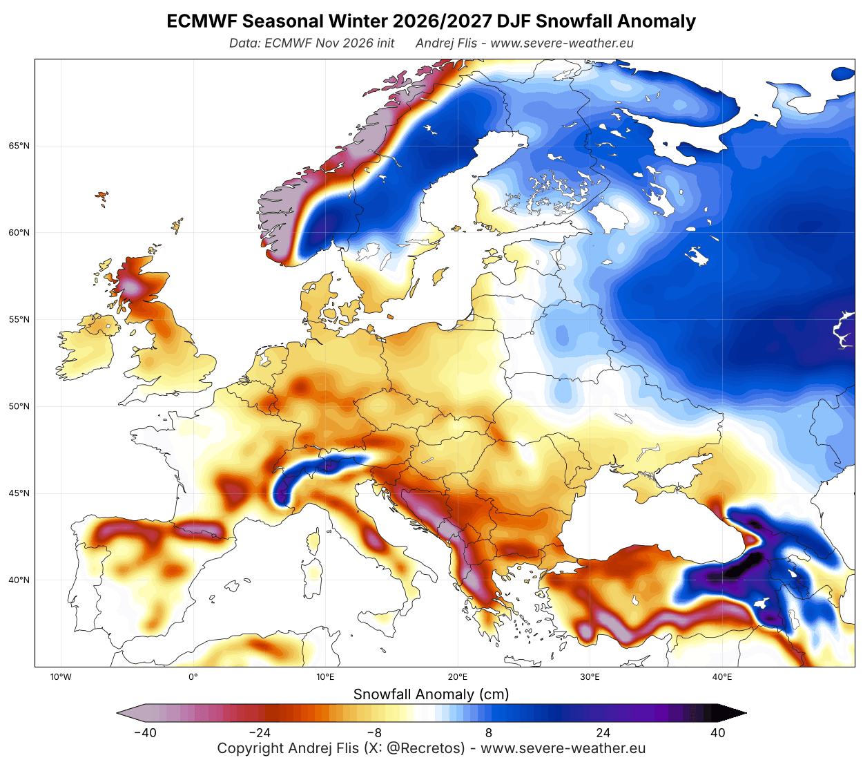
Most ski resorts can face a difficult season with below-average natural snowpack. With abundant moisture from the Atlantic, the highest elevations above 1,800-2,000 m (5,900-6,600 ft) are likely to see above-normal snowfall where temperatures remain cold enough.
For a full breakdown of the latest Winter 2026/2027 trends, you can use the Winter Explorer below. Then we will look at a Polar Vortex collapse risk emerging for mid-winter, and the first extended-range trends for the start of Winter.
Winter 2026/2027 Month-by-Month Forecasts for Your Area
Before you check your own region/state in the Winter Explorer, here is how the latest forecast shows the season evolving month by month in the United States, Canada, and Europe:
December 2026: Canada and the northern U.S. start milder under a high-pressure zone, while the southern Plains and the Gulf Coast start slightly colder, with a wetter pattern for California and the Southeast. Europe starts mild in the south and closer to normal in the north.
January 2027: The pattern amplifies, with the colder air shifting into the Southwest and the southern Rockies. This is the wettest month for California and the Southeast. Europe turns milder everywhere, most notably in the north and east.
February 2027: The coldest and snowiest-looking month for the central, southern, and eastern U.S., with below-normal temperatures over the southern U.S. and into the central Plains. Europe stays mild, but with more snowfall across the north and northeast.
March 2027: The pattern starts to slowly ease off, with a mild northern U.S. and a still colder Southwest, southern Plains, and Gulf Coast. Europe stays mild in the south, with the north closer to normal.
In this Winter Explorer, you can check the seasonal and monthly winter forecast breakdown for each state, country, and province. It covers two long-range models, the ECMWF and UKMO. All images are high-resolution, so you can freely pinch-zoom on mobile.
But there are also other forces at play besides the Super El Niño, much higher up in the stratosphere. A potential Polar Vortex disruption is appearing in mid-winter that could change the second half of the season if verified.
Polar Vortex Forecast: A Growing Mid-Winter Disruption Signal
The Polar Vortex is a broad winter circulation over the northern (and southern) hemispheres. You can imagine the Polar Vortex as a spinning wall over the polar regions, rising from the surface into the stratosphere (over 50 km/31 miles high), trapping the cold polar air inside.
This whole winter circulation is divided into two layers: the stratosphere (at higher altitudes) and the troposphere (at lower altitudes). A strong, stable Polar Vortex acts like a barrier, locking the coldest air over the North Pole and creating milder conditions for the United States and Europe, but it can be disrupted and release that cold.
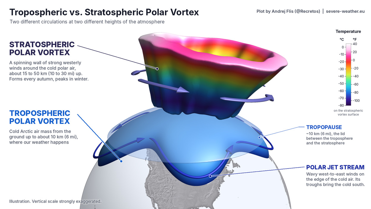
The main disruption usually arises from a rise in pressure and temperature in the stratosphere, known as a Sudden Stratospheric Warming (SSW) event, or from other dynamics that can originate from the lower levels.
To show the Polar Vortex dynamics, I produced a high-resolution 3D video below. This video shows the Polar Vortex structure during a major Sudden Stratospheric Warming (SSW) event in mid-winter, and the typical weather result, bringing cold air to the central and eastern United States and parts of Europe.
We measure the strength of the Polar Vortex by its winds. Below is the most recent ECMWF seasonal forecast, which shows an unusual weakening of the stratospheric westerly winds in January and into February. You can see that as the black line (forecast) goes well below normal (red and blue lines), indicating a likely disruption event.
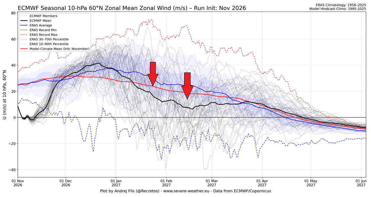
You can also see a weakening and a reversal (negative winds) in early November, which is the recent Polar Vortex disruption, the earliest such event on record. But because it's so early in the season, its impacts are more modulated than in mid-winter.
We can see the same trend in the UKMO forecast for the stratosphere. It shows the same Polar Vortex slowdown and disruption in the January-February period, reaching well below the normal line, and it is unusual to see this far in advance.
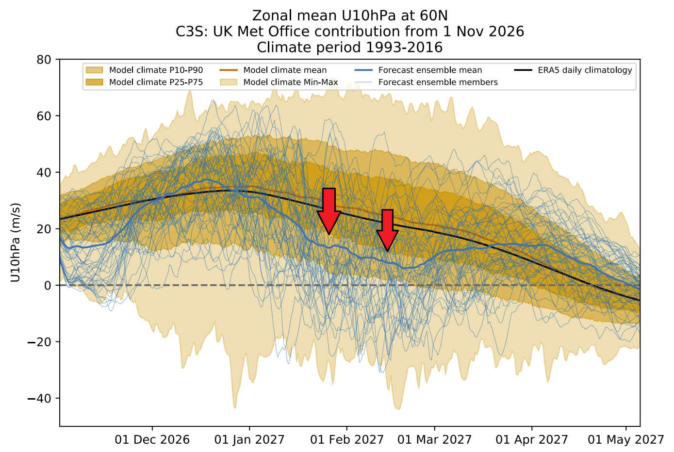
A Polar Vortex slowdown or reversal means that its strong westerly winds are weakening. If those winds reverse direction high in the stratosphere, we have a major Stratospheric Warming event. That disruption can reach the lower atmosphere, disturb the jet stream, and increase the chance of cold-air outbreaks farther south.
The ECMWF seasonal forecast for 2026/2027 below shows a temperature anomaly in the stratosphere. You can see the current Stratospheric Warming in November, but what is more interesting is the stronger Polar Vortex in December, and then a new round of Stratospheric Warming starting in January.
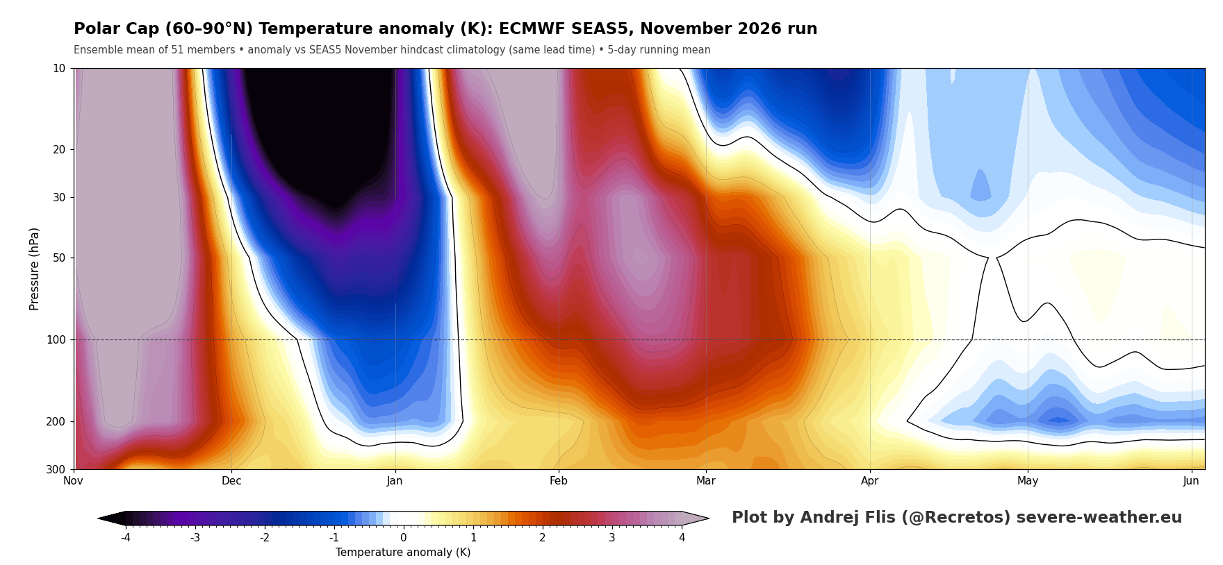
The November Warming looks like a stronger anomaly because it's so early, and it is also better resolved by the model. The January Stratospheric Warming anomaly is further into the future, and in a different atmosphere, so on raw numbers, it actually looks impressive for the lead time.
But what would a Stratospheric Warming event in January-February mean, given that we are in an El Niño season? Below is the average temperature and snowfall anomaly in the first 30 days after major SSW events in an El Niño season, using climate model simulations.
On average, colder conditions become more likely across large parts of the United States and west-central Canada, following a collapse of the Polar Vortex circulation. You can also see an increased snowfall trend over the central, eastern, and northeastern United States, extending into southeastern Canada.
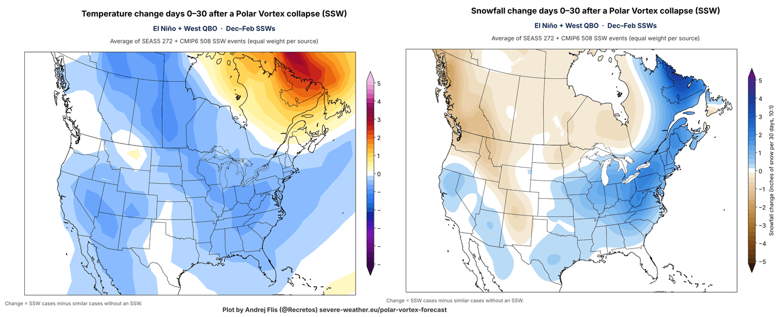
This is similar to the pattern that we saw last winter over the United States, with a disrupted lower Polar Vortex core moving into North America. It created a “Polar Express” pattern, as seen in the image above, with a cold corridor from the polar regions across central Canada into the United States.
Over Europe, the same Stratospheric Warming events show a tendency for a cold air corridor from the northeast, reaching towards northwestern and north-central parts, while the southeast turns milder. The snowfall anomaly also shows the expected response of increased snowfall over a large part of the continent.
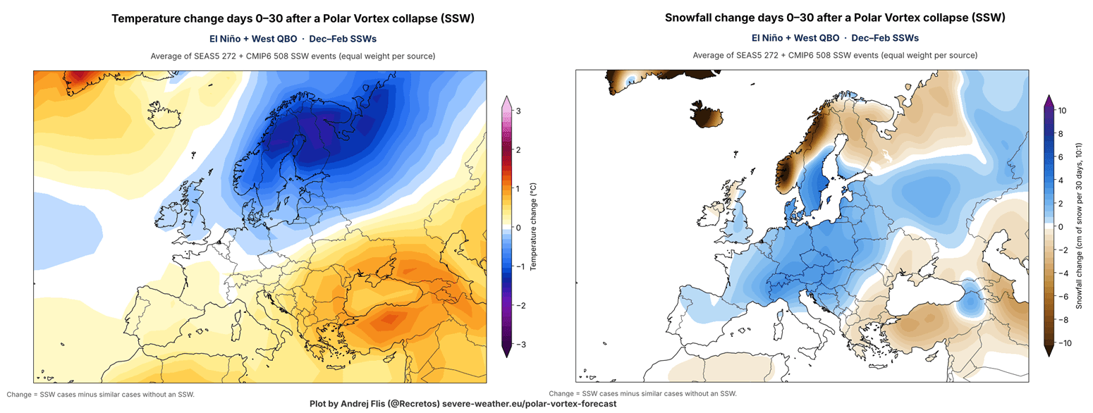
The Polar Vortex can behave very differently from one winter to another, so the two images above are not forecasts, but an average expected response.
Going from mid-winter to early winter, we can now already see the trend for early meteorological winter, using the extended range forecasts.
Early December Forecast: A Chilly Start for the South and East
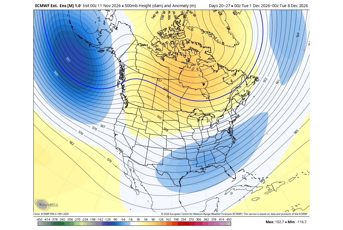
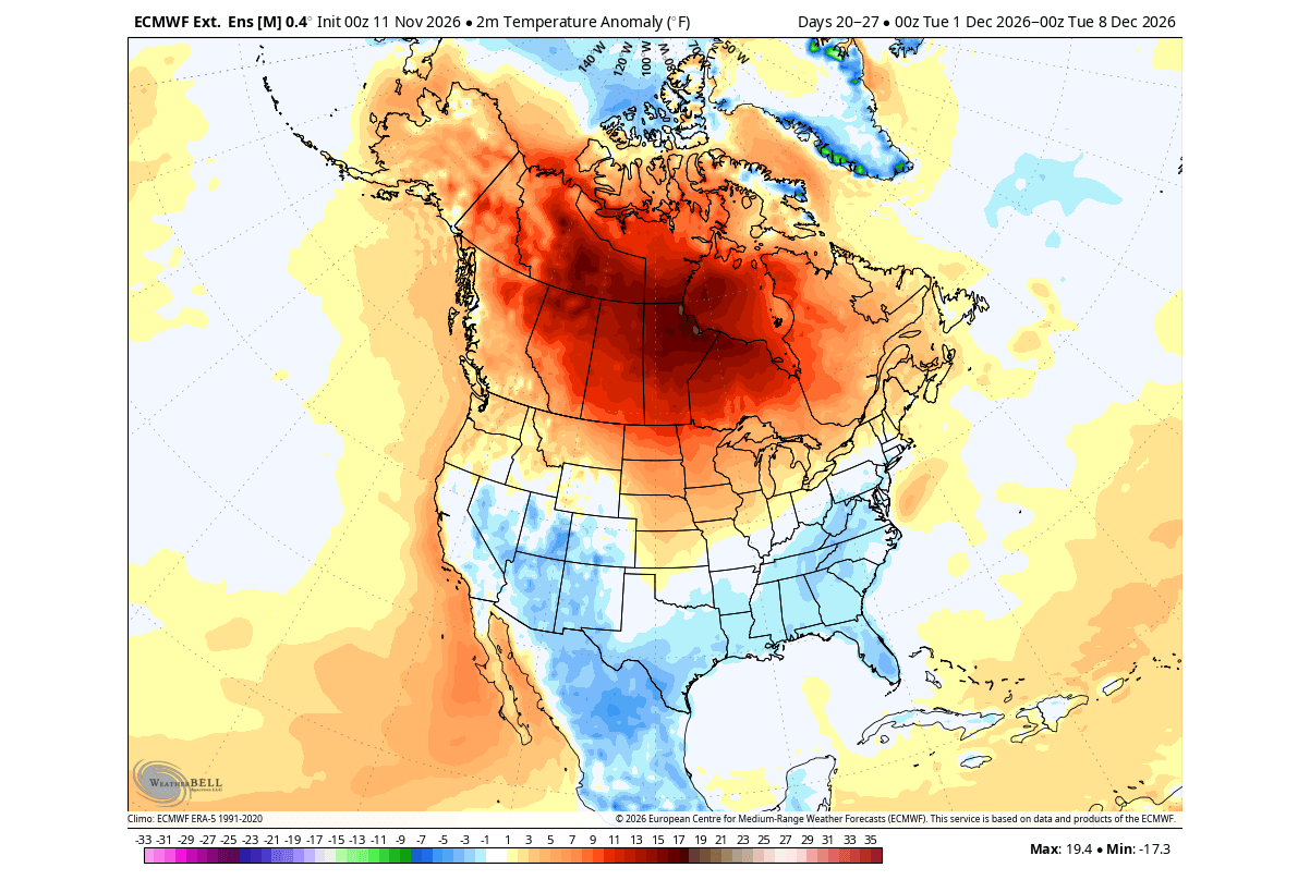
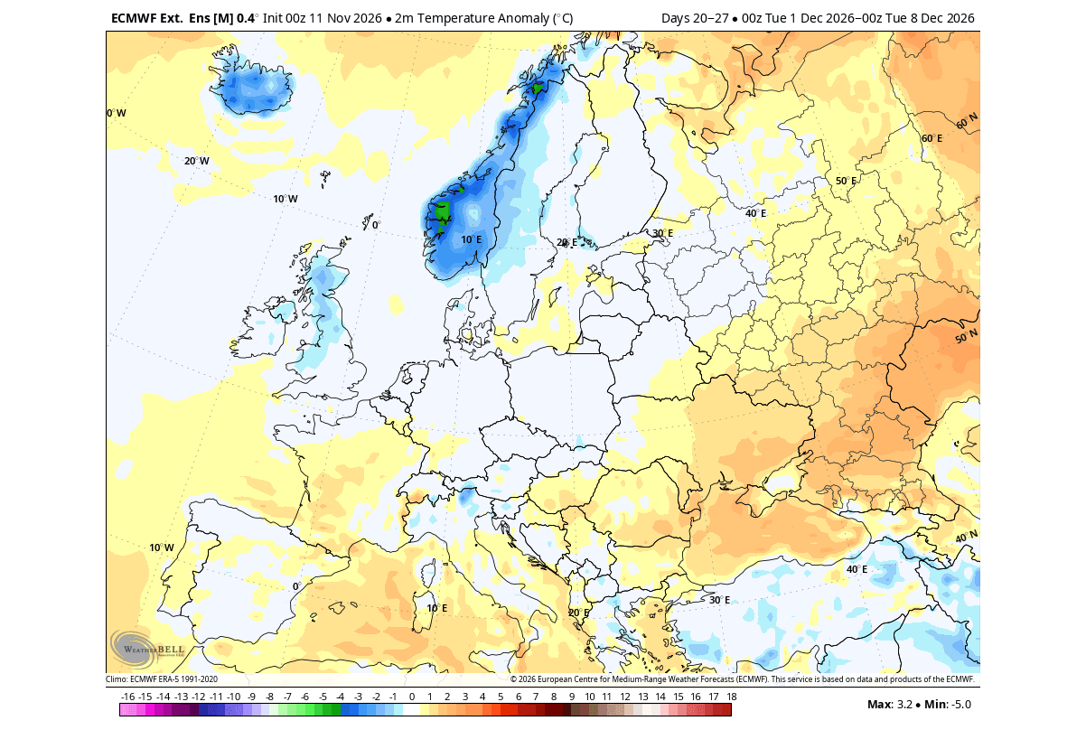
Meteorological winter starts on December 1st and covers the coldest 3 months of the Northern Hemisphere: December, January, and February. We can use the ECMWF extended range forecast to look at the trends for the start of the meteorological winter.
Below is the pressure anomaly for early December, and it already shows an El Niño signature. What is interesting is the already established low-pressure zone over the southern U.S. early in the season, with a high-pressure zone over Canada.
The temperature forecast shows below-normal temperatures over the southern and eastern parts of the United States, mainly driven by the southern low-pressure anomaly. You can also see quite a warm anomaly under the high-pressure system in Canada and the northern United States.
Over Europe, we can also see a trend for below-normal temperatures over the northwestern parts, and normal over central parts. This indicates a potential passage of a low-pressure area over the continent from the northwest.
Winter 2026/2027 Forecast: November Update Summary
Northern U.S. and southern Canada: The latest forecast shows milder-than-normal conditions under a persistent high-pressure zone, with below-normal snowfall across southern Canada, the Pacific Northwest, the Upper Great Lakes, and the Northeast.
Southern and central U.S.: An active Pacific jet stream will bring a stormy season with more precipitation and below-normal temperatures. The November data is making another step towards trending colder and snowier, especially across the Plains, the Southwest, and the Appalachians.
Skiers in the West: The best snow season signal is still over the Sierra Nevada, California, with above-normal snowfall also across the Great Basin, Utah, the Southern Rockies, and the elevations of Arizona and New Mexico.
The Polar Vortex wildcard: ECMWF and UKMO both show a Polar Vortex disruption in the January-February period. Together with an El Niño, this could mean winter impacts in central, southern, and eastern U.S. and parts of Europe, so we are closely monitoring this development.
Europe: Seasonal predictions continue to show a mild, wet westerly pattern, with below-normal snowfall for most areas. The best snow chances are in the north and at the highest elevations of the Alps.
Seasonal forecasts show the expected tendency over the whole winter period of several months, not individual storms. Even in a mild season, a single properly placed system can bring major snow or cold, as past Super El Niño winters have shown multiple times.
Peer-Reviewed Research Used in Writing this Article
- Extreme El Niño Winter Teleconnections: A Distinct and Reproducible Teleconnection Pattern over North America during Extreme El Niño Events - Beniche et al. (2024).
- El Niño and the Polar Vortex: The Teleconnection of El Niño Southern Oscillation to the Stratosphere - Domeisen et al. (2019).
Most charts and analyses in this article are my own, based on ECMWF, ERA5 reanalysis, NOAA CORe dataset, NOAA-NCEI data, and UK Met Office. Some forecast images are from WeatherBell (used under a commercial license).
Don't miss: The Polar Vortex Is Collapsing in November: What It Could Mean for Your Winter
We will keep you updated on the global weather pattern development, so bookmark our page. Also, if you have seen this article in the Google App (Discover) feed, click the like (♥) or the star button there to see more of our forecasts and our latest articles on weather and nature in general.