Severe Weather Outlook features areas of organized severe weather with threat levels and severe weather threats. Risk levels are divided into seven categories:
TSTM – Thundestorms
MRGL – Marginal risk
SLGT – Slight risk
ENH – Enhanced risk
MDT – Moderate risk
HIGH – High risk
SIG – Significant risk
WNTR – Winter risk
Risk categories stand for the coverage and intensity of organized severe weather. Those could include supercells, squall lines, mesoscale convective systems, wind storms, flooding, snowstorms, or ice storms.
See the latest Severe Weather Outlooks issued:
SEVERE WEATHER THREATS
Severe weather threats include:
- Large hail ( of at least 2 cm in diameter)
- Tornadoes (including waterspouts)
- Wind gusts (convective or non-convective) above 25 m/s (or above 90 km/h)
- Torrential convective precipitation / Flash floods
- Excessive rainfall (100 mm within 12 hours) / snowfall (50 cm within 12 hours)
Extremely severe weather threats include:
- Large hail (of at least 5 cm in diameter)
- Tornadoes of F2 intensity or stronger
- Wind gusts (convective or non-convective) above 33 m/s (or above 119 km/h) or 12 Bft
- Torrential convective precipitation / Flash floods
- Excessive rainfall (150 mm within 12 hours or above ) / snowfall (above 100 cm within 24 hours)
CATEGORICAL THREAT LEVELS
TSTM – Thundestorms – this level is issued for areas where convective storms are expected with >50% probability of occurring in a 40 km radius from a location.
MRGL – Marginal risk – this level is issued for areas where convective storms are expected with <2% probability of organized severe weather occurring in a 40 km radius from a location.
SLGT – Slight risk – this level corresponds to 5-15% probability of organized severe weather occurring in a 40 km radius from a location. Additionally, 5% or higher probability of extremely severe weather is expected. Organized severe weather is expected, but an isolated nature of events and with low coverage.
ENH – Enhanced risk – this level corresponds to 15-30% probability of organized severe weather occurring in a 40 km radius from a location. Additionally, a 5% or higher probability of extremely severe weather is expected. Organized severe weather is expected, but scattered nature of events and with moderate coverage.
MDT – Moderate risk – this level corresponds to 30-45% probability of organized severe weather occurring in a 40 km radius from a location. Additionally, 15% or higher probability of extremely severe weather is expected. Organized severe weather is expected, moderate intensity and coverage.
HIGH – High risk – this level corresponds to 45-60% or higher probability of severe weather occurring in a 40 km radius from a location. Additionally, 30% or higher probability of extremely severe weather is expected. A HIGH risk area will include a more detailed forecast than TSTM, SLGT, ENH or MDT risk areas.
SIG – Significant risk – this level corresponds to 60% or higher probability of severe weather occurring within a 40 km radius from a location. Normally, a major severe weather outbreak is expected with high coverage of severe weather (such as the August 2008 Poland tornado outbreak, hurricane-force windstorms, catastrophic flash floods, or similar).
WNTR – Winter risk – this level corresponds to an enhanced threat for excessive snowfall when >50 cm of fresh snow is expected. This threat does not have additional severity threats, however. All details are included in the Outlook discussion.
Below is the *sample* severe weather forecast across Europe with all threat levels included.
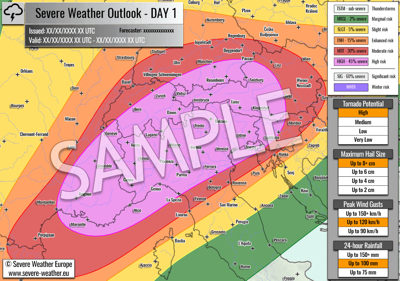
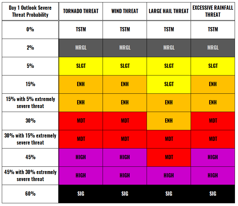
Categories in the forecast represent the chance of severe weather occurring within a 40 km radius from a location. The used level is based on the conversion table of probabilistic risk into the outlook categories. A threat level is upgraded into a higher category if probabilities meet the threshold criteria for the specific threat (e.g. tornado, wind, hail, or rainfall threat).
Severe weather outlook probability to categorical risks conversion:
Each individual threat area includes a detailed forecast map and discussion on the potential of severe weather threats.
MESOSCALE DISCUSSION
These products include shaded risk areas for days following Day 1 and 2. No threat levels are defined. Severe weather threats are included in the description below the forecast map.
Additionally, Mesoscale Discussion is issued which include a broad overview of a developing pattern and threats. Such discussion usually includes model maps and current observations where more attention on possible severe weather threat is needed.
Follow the ongoing severe weather events via:
Severe Weather Europe Facebook page