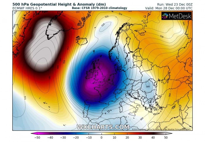
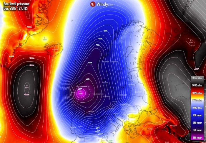
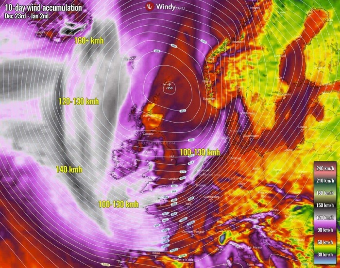
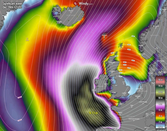
Weatherwise, things are getting serious over the European continent around Christmas and towards the New Year. A significant pattern change across the North Atlantic is forecast, becoming progressive with an impressive deep upper low pushed into western Europe, releasing a winter storm into the UK and turning towards central Europe. A massive snowstorm will hit the Alps on Monday while major waves over the Atlantic coast of western Europe.
In one of our initial discussions a few days ago we have pointed out that something is brewing on the weather pattern across the European continent this Christmas week and into the holiday time. Now things have a remarkably clear signal that a very powerful surface depression and winter storm will develop into western Europe and continue towards central Europe and the northern Mediterranean region after the weekend.
What is also shaping up on both global models, GFS and ECMWF, is now also being confirmed by the regional, high-resolution models. The forecast central pressure should deepen into near 960 mbar, and the low will become very large, basically covering the whole western half of Europe after Sunday. This will also result in much lower temperatures generally and increase snowfall potential into the last week of 2020.
There is a high potential for another major snowstorm for the Alps, now with higher odds that 100 cm to more than 150 cm of fresh snow could hit the Alpine region from Sunday through Tuesday. Roughly over the same areas that were already severely hit by an extreme amount of snow back in early December!
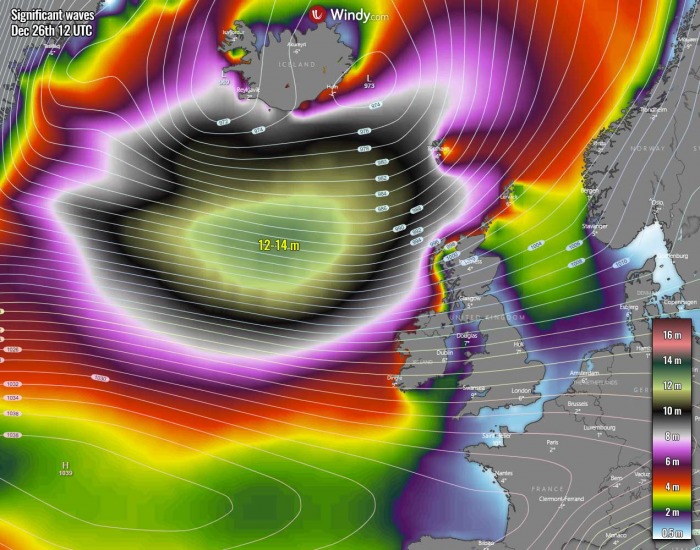
A potentially significant winter storm should bring very large waves along the Atlantic coast of western and southwestern Europe, major wave heights are forecast. Attached below is a video animation of the significant waves developing on Friday, spreading towards Ireland and the UK over the weekend, reaching the coast of France and Spain on Monday.
Further down, we will take a detailed look over this impressive pattern evolution right on Christmas day, becoming progressively robust with the winter weather forecast in the holiday time afterward.
WHITE CHRISTMAS IN PARTS OF EUROPE
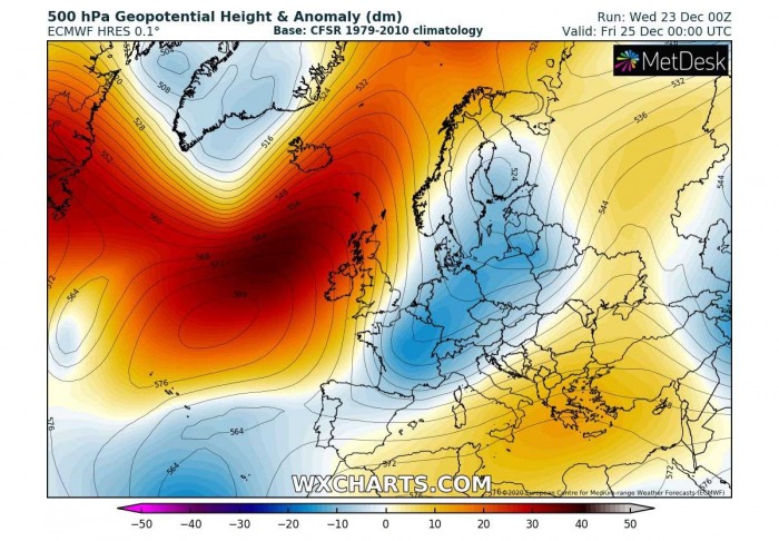
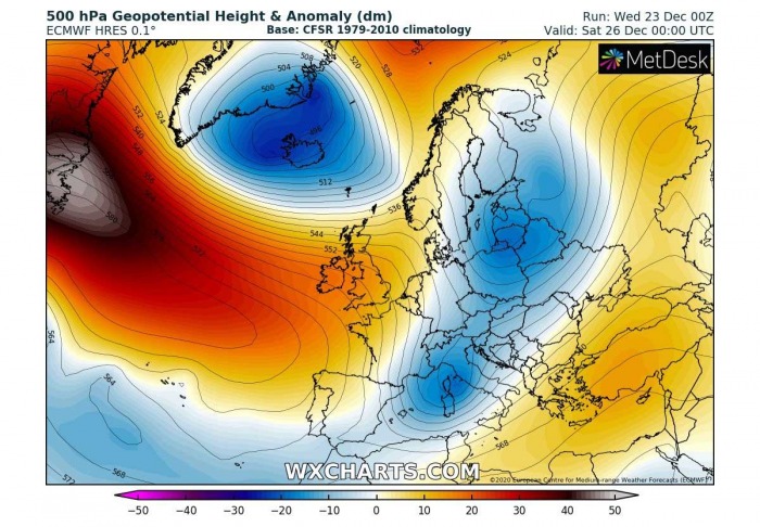
What are we seeing this week and on this attached 500 mbar chart is the general weather pattern flip over the North Atlantic and Europe around Christmas. A strong upper-level ridge is developing over the Atlantic, blocking the zonal westerly flow and establishing a more meridional, northerly flow into the European continent.
A cold front is advancing south over central Europe, and the storm is forecast to deliver winter weather into the Alps and towards the northern Balkan peninsula.
At the same time, to the north of the Atlantic ridge, an Arctic wave is shaping up over Greenland.
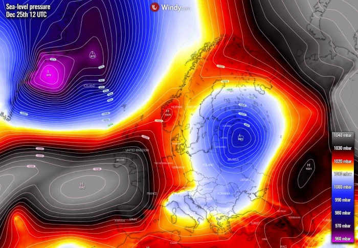
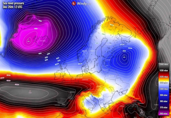
Now, let’s take a look over the surface mean sea-level pressure forecast on Christmas Day. Under the strengthening North Atlantic upper-level ridge, a powerful high-pressure system emerges between the Azores and western Europe. To the east of the ridge, a deep surface low will be ongoing over the Baltic region, with the winter weather forecast to develop.
But the main feature of interest is definitely the new upper wave emerging south from Greenland, resulting in explosive cyclogenesis between Iceland and Greenland. The pressure falls very significantly through Friday, developing a strong cold front blasting into Iceland with a major winter storm, intense snow is forecast.
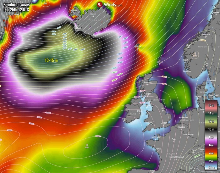
The pressure gradient between the extensive Azores high-pressure system and the newly developing cyclogenesis will be very strong. Therefore, resulting in significant wave heights generating from Greenland towards south-southwestern Iceland and further east towards the Faroe Islands.
While major waves up to 15 meters are likely within the broad areas of the strongest pressure gradient, very high waves up to near 10 meters could also push towards Iceland and Faroe Islands. Moving into the coastal areas from the west-southwest directions.
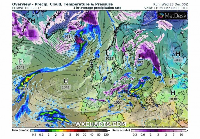
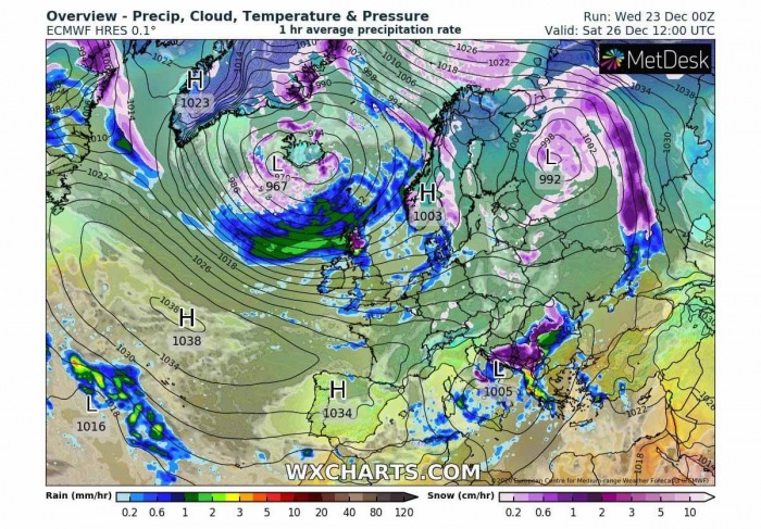
If we take a look over the position of the fronts over Europe, we can see there are three areas of interest actually. An intense snowstorm hits a large part of Iceland, with potentially a significant amount of new snow on Christmas Day.
The second frontal system is grazing across the eastern Baltic region, Belarus into northwestern Russia. Quite an intense snowfall is likely to spread across a broad area, as the parent surface low is rather deep, pumping high moisture into the warm sector seen on the chart.
And then, there is the third feature of interest over the Balkan peninsula. This is actually the same front as will be producing snow in northeast Europe. As the front crosses the Alpine mountain chain through Christmas morning, the rain will turn to snow across parts of Slovenia, Croatia, and further south towards Bosnia into Friday evening.
Also, there will be some fresh snow over the Alps in the wake of the North Mediterranean low.
As we can see, there areas these areas mentioned above, which will experience fresh snow and the actual snowing on Christmas Day.
For the potential of white Christmas over the rest of Europe, please refer to the discussion here:
DEEPENING WAVE FROM THE ARCTIC SLIDES SOUTH
As interesting as it seems for Christmas Day, the general pattern change into a more progressive one will lead to some rough weather developing towards the European continent over the weekend.
Let’s first take a look at the elongated upper wave over the continent. It has two cores, one remains over the Baltic region while the southern core deepens over the northern Mediterranean. This strengthens the ongoing secondary surface depression over Italy and the Adriatic Sea.
As we can see, an upper ridge over the Azores and western Europe is gradually collapsing, but the overall 500 mbar pattern indicates a strengthening ridge towards the Canadian Arctic and Northwest Atlantic.
In other words, this means that the deepening wave to the north ejects Greenland and heads towards Iceland, drifting further southeast towards northwestern Europe on Saturday.
The mean sea-level pressure chart reveals the deepening wave from the Arctic hints at a serious business. The low continues deepening while moving over Iceland, growing its size and also intensifying the wind field. Notice the extreme pressure gradient developing between the Azores high-pressure system and the Arctic low.
There is more than a 70 mbar pressure difference between the two! Violent west-northwesterly winds will result, generally spreading towards western Europe.
The deepening surface low, although rather shallow, is seen over central Italy, as well as the deep low ejecting off the Baltic region into northwestern Russia.
Such a broad but intense pressure gradient and hurricane-force winds will support further development of high sea waves, those should maintain 12-14 meters height and remain significant. Gradually spreading towards western Scotland, Ireland, and Northern Ireland on Saturday into Saturday night.
As can be seen, the channel of major waves will be very large, so we can expect these waves to gradually spread into the Bay of Biscay and also to the north of the UK.
The surface front position forecast for the day after Christmas reveals the potentially heavy snowfall will continue spreading south across the western Balkan peninsula countries, especially across southern Bosnia, southern Serbia, and Montenegro. Heavy rain is expected along the Adriatic coast there as well.
While the front, associated with the Arctic trough, loses its definition while drifting south of the Faroe Islands towards Ireland and the UK.
Both the front and the surface low in northwestern Russia move further east and gradually weaken. But snow is forecast to continue along the front for most of Saturday.
MAJOR DIPOLE PATTERN DEVELOPS ON SUNDAY
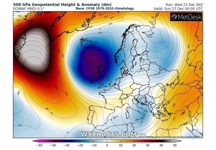
Now we can see what comes down from the Arctic region. The general pattern overview on Sunday indicated an exceptional dipole pattern over the North Atlantic and western Europe.
We can see an extreme anomaly of both, the powerful upper ridge over the Northwest Atlantic and the deep low over northwestern Europe will develop. Literally going ‘off the charts‘.
So, a *very* significant warming will develop in the mid/upper-levels over the northwest Atlantic, but significantly colder temperatures will follow to its east, towards western Europe.
Further southeast, both upper cores associated with an elongated wave across Europe will weaken while moving further south-southeast.
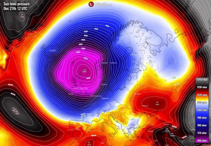
The surface pressure indeed follows the significant deepening of the upper-level cold-core low, developing a very large depression centered over the UK and the North Sea. Weather models are hinting its central pressure should be near 960 mbar or even slightly lower during its peak on Sunday.
High-pressure systems are surrounding this large deep low, over the Azores, Greenland, and also with a very powerful 1050+ mbar pressure far east over Russia.
The deep low is dominating most of Europe, delivering colder air mass into western and southwestern Europe, but much warmer air mass ahead of it into the Balkan peninsula again. Also, further east into eastern Europe.
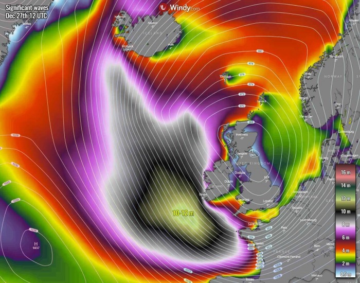
Although the impressive surface pressure gradient over the Atlantic will begin weakening on Sunday, the broad waves generated from the day before will continue spreading towards Ireland and also further southeast across the Bay of Biscay towards France and Spain.
The most significant waves will maintain 10-12 m heights, being 8-10 meters high when arriving near the southwestern Irish coast, as well as southwestern England and northwestern France.
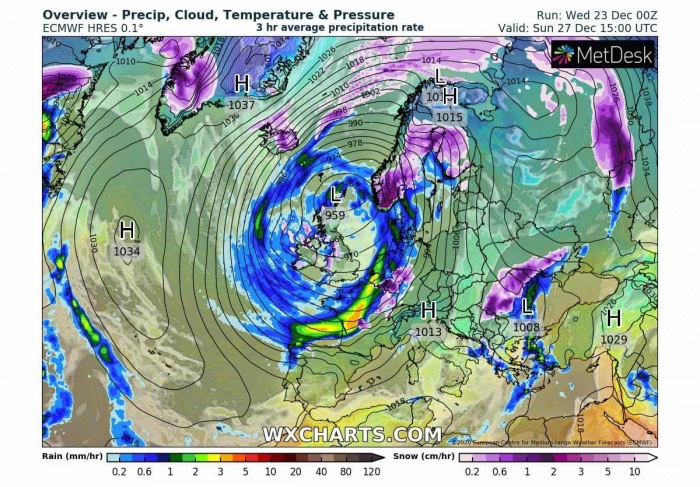
The main cold front, associated with the deep low, will begin re-organizing while moving across western Europe on Sunday. Delivering heavy rain, also partly convective, into northern France, Benelux, and western Germany by the afternoon. Winds could be damaging locally, especially along the portions of the English Channel along the Dutch coast of the North Sea.
Some snow or even sleet or ice storm could develop in western Germany, given the arriving much warmer air mass in the mid-level, but still, cold temperatures remaining near the surface. Although chances are low as the whole storm’s warm advection is very large, freezing rain and some black ice are possible.
Very heavy snow is forecast to develop over southwestern Norway, the area being in the front-end quadrant of this winter storm. Significant amounts of snow are expected. Snowfall will also expand further northeast across central Scandinavia.
The surface front extending from western Russia across the northern Black Sea into the Aegean Sea will be weakening, generating heavy rain over the Black Sea but also snowfall over parts of Romania, Moldova, and Ukraine.
Some additional winter weather with orographic snowfall will also develop across the eastern parts of Iceland, as a result of a moisture advection to the north of the storm.
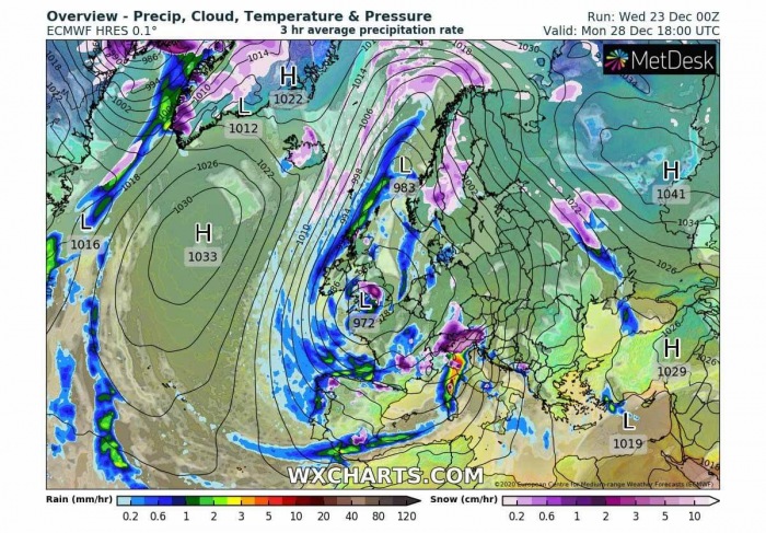
DEEP LOW STRENGTHENS OVER WESTERN EUROPE ON MONDAY
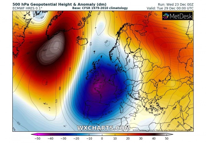
While maintaining its large size, a deep cold core will be drifting south on Monday and intensifying. Its center will be gradually moving across Ireland and the UK and deepening. The low will now become a dominant feature of the weather pattern over Europe next week.
The extreme anomaly of the upper-level pattern remains over the Northwest Atlantic and the Labrador Sea, also expanding into Greenland. An impressive, textbook dipole pattern is now even stronger than on Sunday.
Weather models basically don’t have a hard time handling the situation but as funny as it might look, the scales are not catching it. Literally ‘of the charts’ for another day.
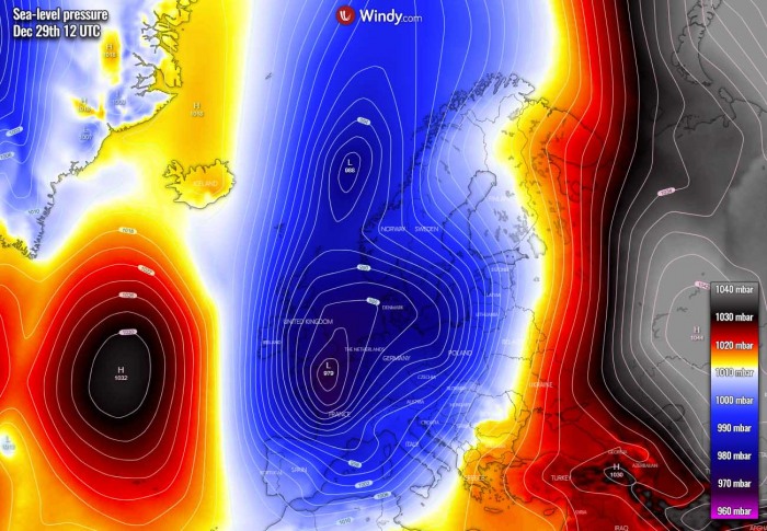
In response to the powerful upper-level ridge into Greenland, the surface pressure also significantly rises over the North Atlantic, probably into the near the 1035 mbar range. While the main surface low to the east, remains very deep, although after its lowest pressure peak on Sunday.
The central pressure should rise into the upper 960s, while the low is being centered over the UK.
Still, an extreme pressure difference will exist between the two, at least 60+ mbar. The low will cover much of the European continent, expanding also into a large part of the Mediterranean, northern Balkan peninsula, eastern Europe, and Scandinavia.
Winds will definitely be very strong also on Monday, even supporting some hurricane-force speeds over the open North Atlantic, to the west of the core where the strongest pressure gradient will exist. Peak gusts could reach 130-150 km/h. Also 120+ over the Bay of Biscay, the Atlantic coast of France and southwest England as well as also over the English Channel into the southern North Sea.
This area of severe winds, however, strongly depends on the exact position of the surface low while moving south across the UK and Ireland.
The waves and large swell will definitely take an advantage of the very strong pressure gradient again, so they are expected to maintain significant wave heights while spreading across the Bay of Biscay into the Atlantic coast of France, Spain, and northern Portugal.
The highest waves could reach more than 10 meters also on Monday.
An interesting picture, but also a dangerous winter storm signal, now comes after looking over the front’s position and precipitation forecast on Monday. The main cold front, associated with the deep surface cyclone will enter the Mediterranean, therefore, intensifying precipitation with a deepening low over North Italy.
In other words, this means very intense, excessive snowfall is expected to develop for the Alps. And indeed storms, including some severe storms, further south-southwest over Italy. Flooding could become an issue locally, while avalanche threat will increase over the southern Alpine flank (northern Italy into southern Austria or even northwestern Slovenia).
An important point to note is also the potential for snowfall developing over parts of the UK, precisely England or even Wales, on Monday. The deep upper cold-core low being centered over the UK should support very low mid-level temperatures, which could be enough for precipitation being as snow most of the time while winter storm continues south. Indeed it again depends on the position of the core aloft.
On Monday, the GFS model is also a hinting a potential ice storm to develop with s short-wave moving into eastern Europe. Although the warm advection in the mid-levels will be strong, strong thermal inversions in the lowest levels could keep the temperatures below freezing.
Therefore, freezing rain and ice storm are possible over Ukraine into western Russia if this wave develops a significant amount of rain over the still cold near-surface layers there.
RIDGE WEAKENING BUT COLD CORE REMAINS STRONG ON TUESDAY
Although Tuesday next week is actually the 6th day ahead from now, we can take a look over the trends of how the upper wave pattern will evolve.
The upper low continues maintaining its very deep core also on Tuesday, while its core very slowly over further south into northern France. But it still covers a large part of Europe, remaining a dominant feature for the general pattern through mid-next week.
The extreme anomaly of the strong upper-level North Atlantic ridge finally begins lowering but remains very strong. Actually, it is an important factor in the pattern evolution over Europe as it keeps blocking the zonal westerly flow over the Atlantic, so it delivers more cold into the western half of Europe.
However, this also means that the eastern half of Europe should remain in very warm weather, so no winter weather is forecast with this storm there in the early days next week. But the cold weather will maintain over the western half of Europe, including the Iberian peninsula.
After Tuesday, the surface low maintains its large size but continues weakening. And also, there are some uncertainties regarding the position of the parent upper core after Monday, so the forecast has a rather low probability after Day 5.
Tuesday’s surface pressure forecast does confirm the upper low being the dominant weather feature over the European continent. The deep low is still very large, centered over France and Benelux, but it keeps the lower pressure all from Scandinavia across the Baltic region, central Europe down south to the Mediterranean.
A channel of meridional, southerly warm winds is well-visible to its east, against the strong high-pressure system in western Russia.
As the North Atlantic ridge is forecast to weaken, it also lowers the surface pressure but it remains high. A textbook channel of strong, meridional northerly winds exists between the Atlantic high and west European low. With still a 60+ pressure difference between these two large scale features.
In other words, this means that the weather pattern next week will be generally maintaining its winter mode and additional snow is forecast in some parts of Europe.
We will monitor the pattern evolution further and keep you updated with further details on the next week’s snowfall potential over the weekend.
QUITE SOME SNOW OVER EUROPE, EXTREME AMOUNT OVER THE ALPS
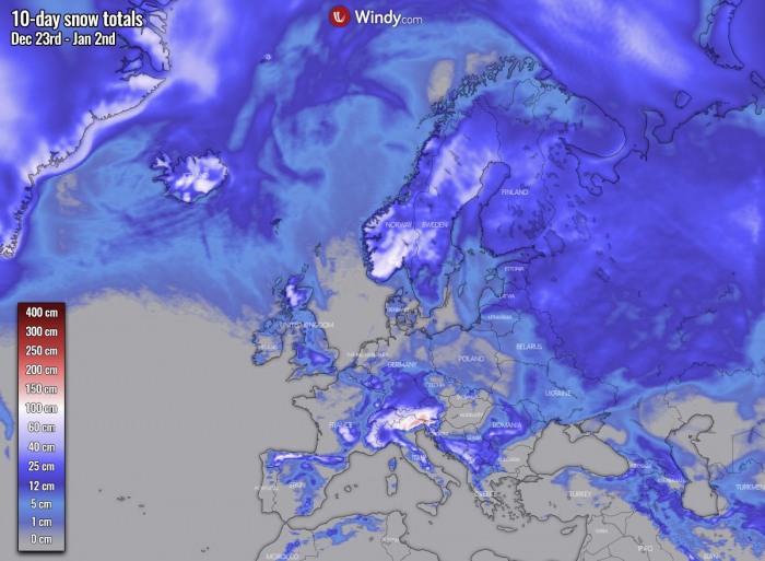
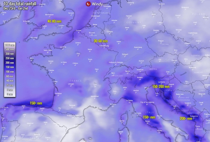
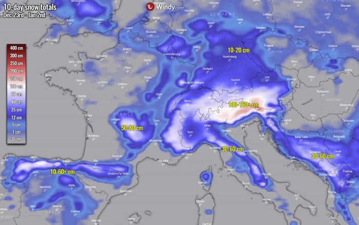
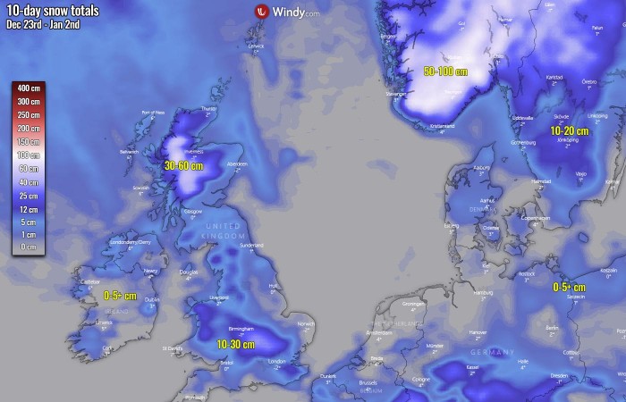
Nevertheless, this generating changing pattern definitely is rising the potential for snow periods through the rest of December and also into the early days of New Year over Europe. Attached below is the total amount of snow by the ECMWF model over the following 10 days.
A huge amount of fresh snow is forecast for the Alps, also parts of Scandinavia and Iceland.
Indeed, some parts of Europe will also experience a lot of rain, if we remember how far south the deep low will penetrate. This means a huge amount of warm air and moisture will spread into the eastern half of our continent, supporting rain with the moving fronts.
A particularly high amount of precipitation (both rain and snow) is forecast with this whole winter storm in the 10-day period, particularly for southwestern Scandinavia, Iceland, northern Iberia, across central Italy, the Alps, and the western Balkan peninsula.
Some areas will receive more than 200 mm of precipitation in total.
One area, in particular, is the Alpine region where again, on Monday, a very significant winter storm and an extreme amount of snow is forecast. Weather models are trending towards an amount of 100 to more than 150 cm of fresh snow for the Alps. Across northeast Italy, south Austria, and northwest Slovenia.
As the attached forecast chart covers a 10-day period, we can also see there is potential for quite some snow in other parts of central Europe, the Balkans, and the Iberia.
Up to 50-80 cm over the Massif Central is possible until the New Year, 30-60+ cm over the mountain chain across northern Spain and Pyrenees. also 30-60 cm over the western Balkan countries, including Bosnia and Herzegovina, Montenegro, southern Serbia, and northeast Albania. As well as the northern Apennines.
As mentioned earlier, a huge amount of snow is likely to develop across southwestern Scandinavia, especially over the Norwegian part where 50-100 cm or even more locally is likely over the next 10 days.
Quite some snow, 30-60 cm, is also possible across the Scottish Highlands after Christmas.
And as the ECMWF model forecast is simulating, there are quite reasonable chances that the upcoming winter storm will develop a decent snow cover in parts of western Europe. A couple of cm of snow is possible over Ireland and Northern Ireland, Benelux, Denmark, and northern Germany.
Some quite impressive amounts of snow are forecast for parts of England and Wales, as we discussed above. During the weekend into early days next week, when the upper core travels south over the UK, rather high chances for snowfall exist.
Don’t miss a chance for a nice gift for your friends, family or someone special… Weather calendar could be the perfect gift for them – see below:
