March weather patterns over North America are forecast to undergo a real power struggle between winter and spring. Rapid changes in pressure anomalies will also bring changes in temperature, with the colder weather pattern looking to prevail over the eastern United States as we go into mid and late March.
The transition from winter to spring can sometimes get very energetic as seasonal temperature and pressure patterns change. March 2024 will be no different, with the extra help from the stratospheric anomaly left behind by the collapsed Polar Vortex.
We will look at the latest atmospheric conditions, along with the stratospheric anomaly, how it all connects in the lower levels, and how this was already forecast over two weeks ago.
POLAR VORTEX SPINS OUT
We often talk about the polar vortex, and there are many explanations out there of what it actually is. In simple terms, it is just a name that describes the broad winter circulation over the northern (and southern) hemispheres.
The polar vortex extends high across different layers of the atmosphere. The lowest level is called the troposphere, where all weather events occur. But above that, we have the stratosphere, a deeper and drier layer.
For this reason, we separate the polar vortex into an upper (stratospheric) and a lower (tropospheric) part. They both play their role differently, so we monitor them separately. But both parts together form the weather circulation across the Northern Hemisphere during the colder half of the year.
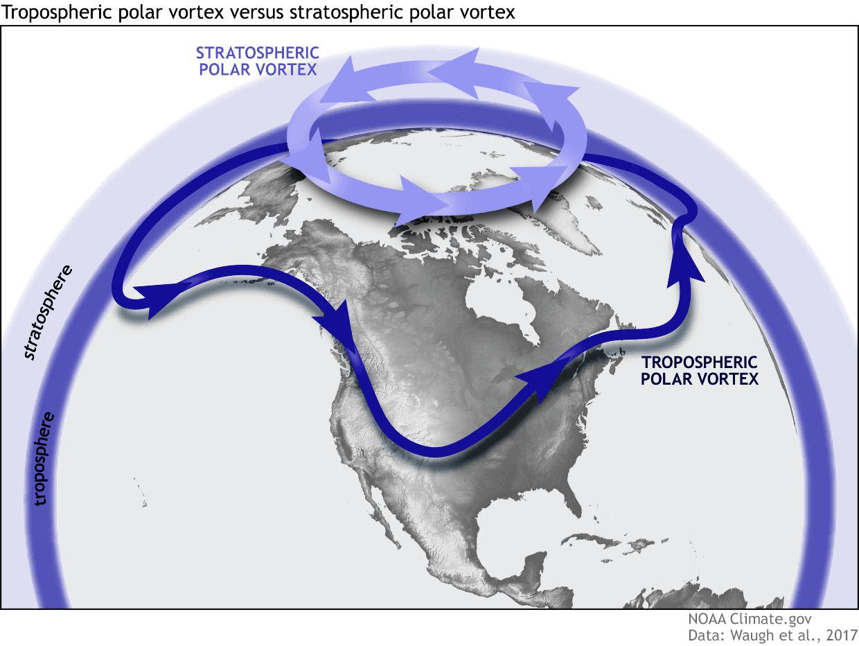
To keep things simple, all you need to know is that the upper and lower parts of the polar vortex are connected. Changes in the upper part can significantly impact the weather anomalies in the lower parts of the atmosphere and the weather at the surface.
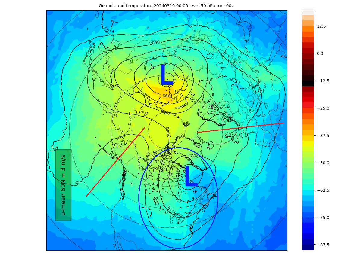
Below is the latest analysis of the stratosphere at the 10mb level, which is at around 30km (18.5 miles) altitude. The polar vortex is shown as the low-pressure area (L) and the strong stratospheric high-pressure area (H). You can see that the high is much stronger than the polar vortex, which is pushed out of the north pole.
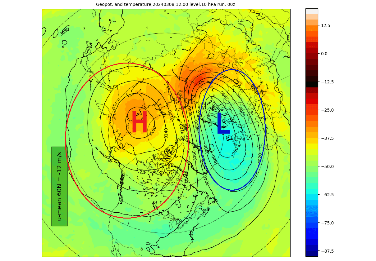
This is a currently ongoing Stratospheric Warming event, seen also with the much above normal temperatures over and around the polar circle. This, of course, has repercussions for the weather patterns below.
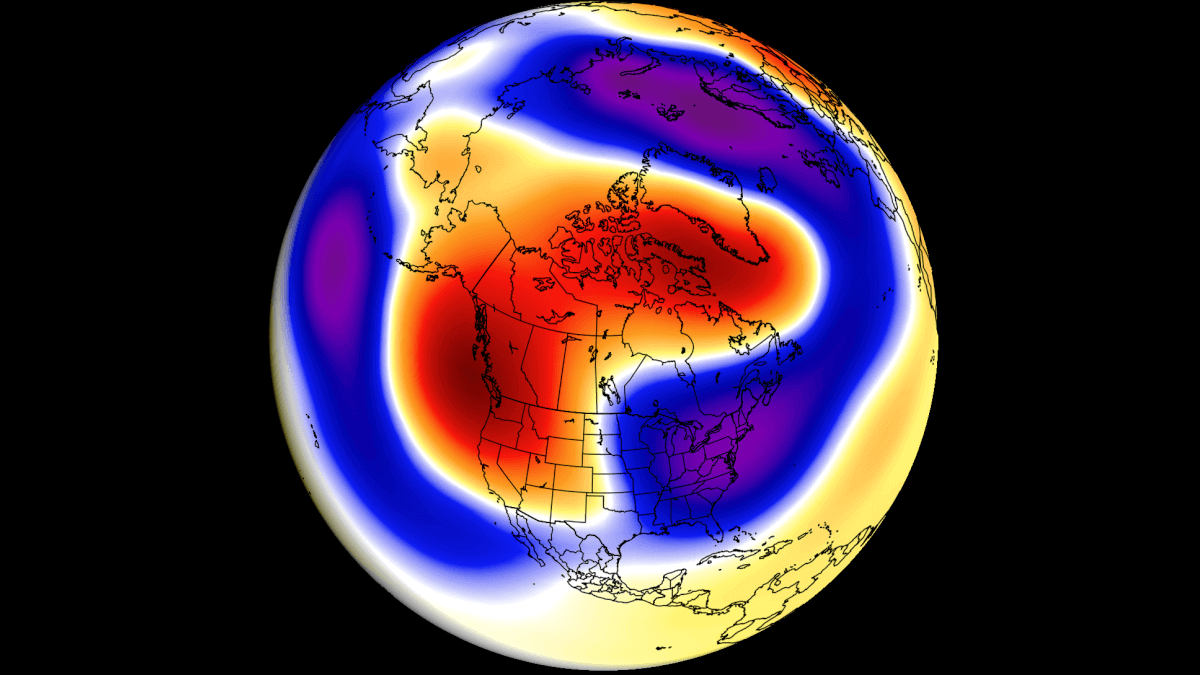
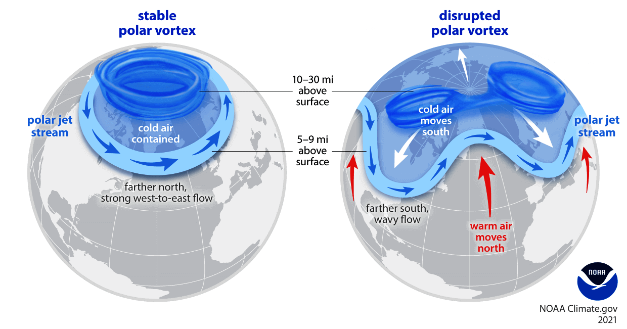
When the polar vortex is strong/stable, it usually means strong polar circulation and jet stream. This locks the colder air into the Arctic Circle, creating milder conditions for most of the United States.
In contrast, a weak/disrupted polar vortex weakens the jet stream pattern. As a result, the colder air is harder to contain and can escape more freely from the polar regions into the United States or Europe. Image by NOAA.
Below, you can see the 2024 pressure anomalies in the atmosphere, from the ground up to around 50km (31miles) altitude. You can see the first stratospheric warming event in early January, connecting all the way down to the surface. Another (weaker) event occurred in mid-February.
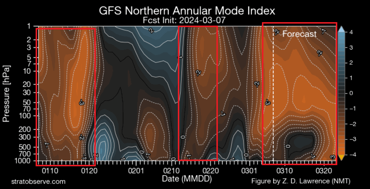
But you can see a much stronger atmospheric anomaly currently ongoing in the third marked box, which also contains the forecast data. It shows that the atmospheric pressure anomaly is forecast to connect from the stratosphere down to the lower levels, impacting the spring weather patterns.
Based on this data, we can see the anomaly connecting lower down in around the second half of March. Even before that, a power struggle of pressure systems in starting to unfold over the United States, connected with the very process that created the strong anomaly in the stratosphere.
We produced a video animation below that shows the temperature forecast trends for March and early April by the ECMWF extended forecast. You can see how the weather patterns completely reverse, with warm anomalies being replaced by cold spring air in the second half of the month over the eastern United States and eastern Canada.
We will further explain this weathering process below, with the latest forecast graphics for the next few days and weeks.
WHEN PRESSURE SYSTEMS DANCE
Looking at the latest pressure anomaly forecast for the next few days, we can see a fairly disrupted weather pattern. A low-pressure area is over the Aleutians and western Canada, helping to raise a ridge over the northern United States and eastern Canada. Another zone of low pressure is seen across the Atlantic and into Western Europe.
This pattern configuration is also helping to disrupt the polar vortex above, sending large amounts of energy up into the stratosphere. So, while this pattern currently runs our weather, it also helps to create atmospheric anomalies that will impact our weather in the following week.
Looking at the temperature forecast for Monday, we can see a cold front passing across the central and eastern United States. Cooler temperatures are forecast across the eastern Midwest, with a northerly flow bringing slightly cooler airmass also into the deep south.
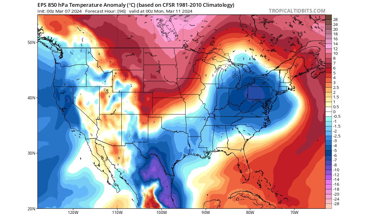
Behind the cold front, we see a growing warm anomaly across the northern United States as a high-pressure ridge is building.
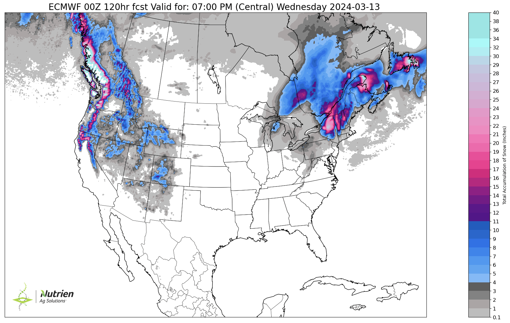
Looking at the snow precipitation forecast for this period, you can see that snowfall is expected around the Great Lakes, over parts of the Mid-Atlantic, and into New England. Snowfall also continues over the higher elevations of the western United States. Image by AG Weather
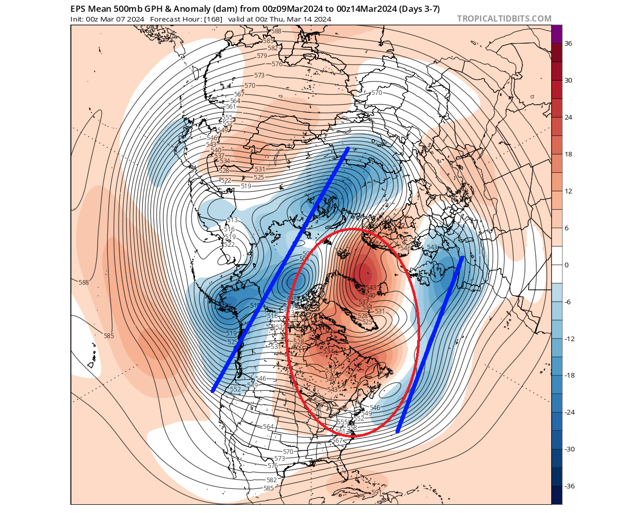
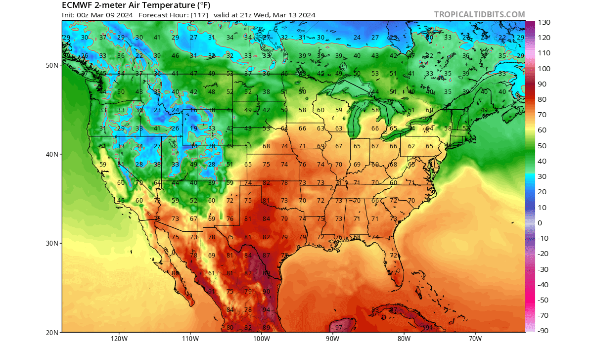
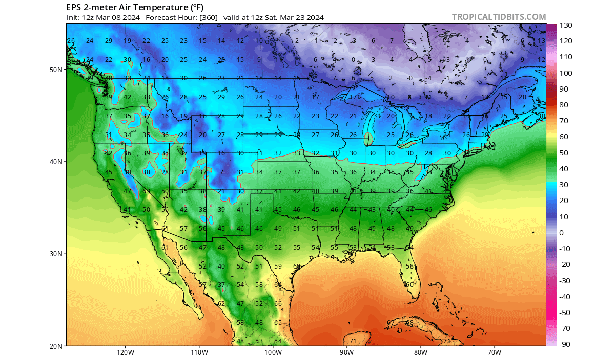
Looking further ahead into next week, you can see a strong warm anomaly extending over much of the northern, central, and eastern United States. This is due to the high-pressure area expanding over the United States.
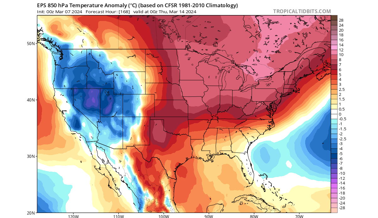
The temperatures are expected to reach into the 60s (F) all the way up into the upper Midwest and Mid-Atlantic. This is higher than normal for this time of year across much of the northern and eastern United States.
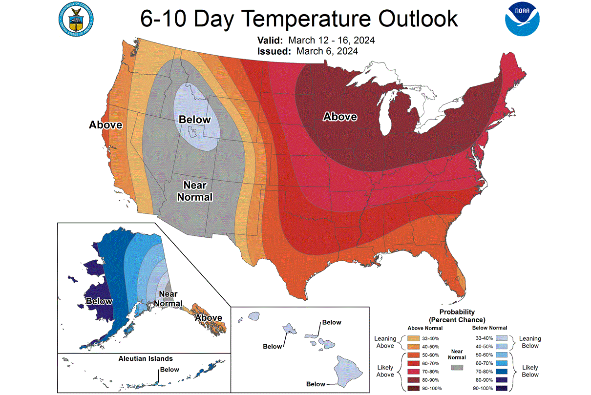
The official outlook from NOAA also shows this unusual zone of above-normal temperatures across much of the central and eastern United States. This is driven by the expansion of the high-pressure anomaly and the warmer airmass that it brings along on the southerly winds.
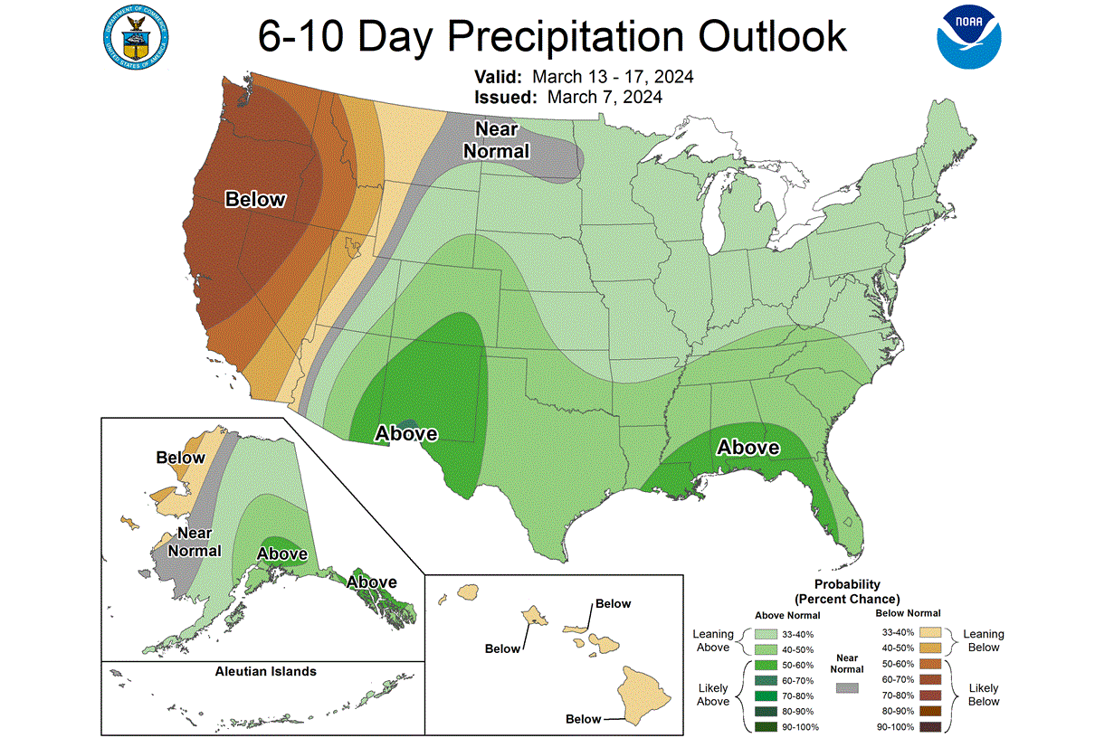
Looking at the precipitation forecast, we can see that the warm southerly winds will also bring along a lot of moisture and precipitation. More precipitation is expected over the southern parts of the United States.
But while the warm spring weather expands across the central and eastern United States, the anomaly in the stratosphere is starting to descend down to the lower levels.
ECHOES OF THE ATMOSPHERE
We know that the upper polar vortex is currently experiencing disruption due to a high-pressure anomaly in the stratosphere. Pressure anomalies in the stratosphere tend to take some time to descend, and so we are now seeing this process in the forecast.
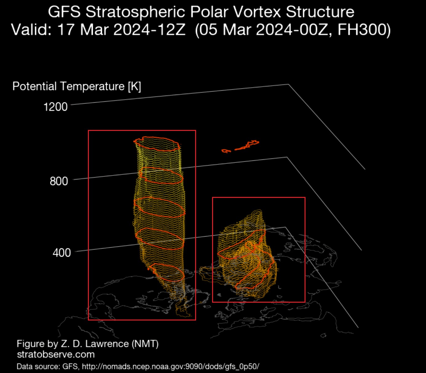
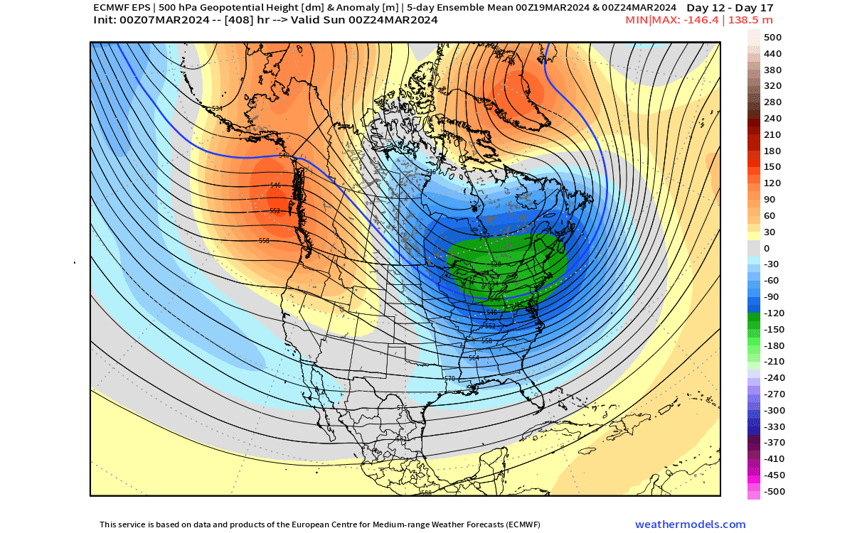
Looking below, we see the forecast of the lower stratosphere at around 20km/12.5 miles altitude around the 19th of March. You can see the main circulation broken at this altitude, split into two separate cores, with a warming anomaly and a ridge between both cores.
This can be seen even better if we look at the polar vortex in its true 3D structure around this date. Below, you can see the 3D forecast, which shows the two separate cores of the polar vortex, one over Siberia and a stronger remaining one over North America.
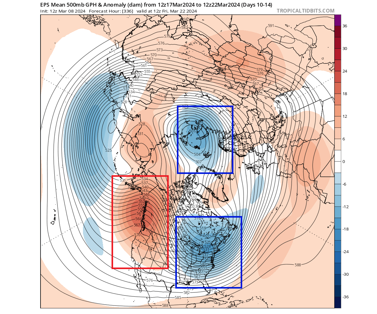
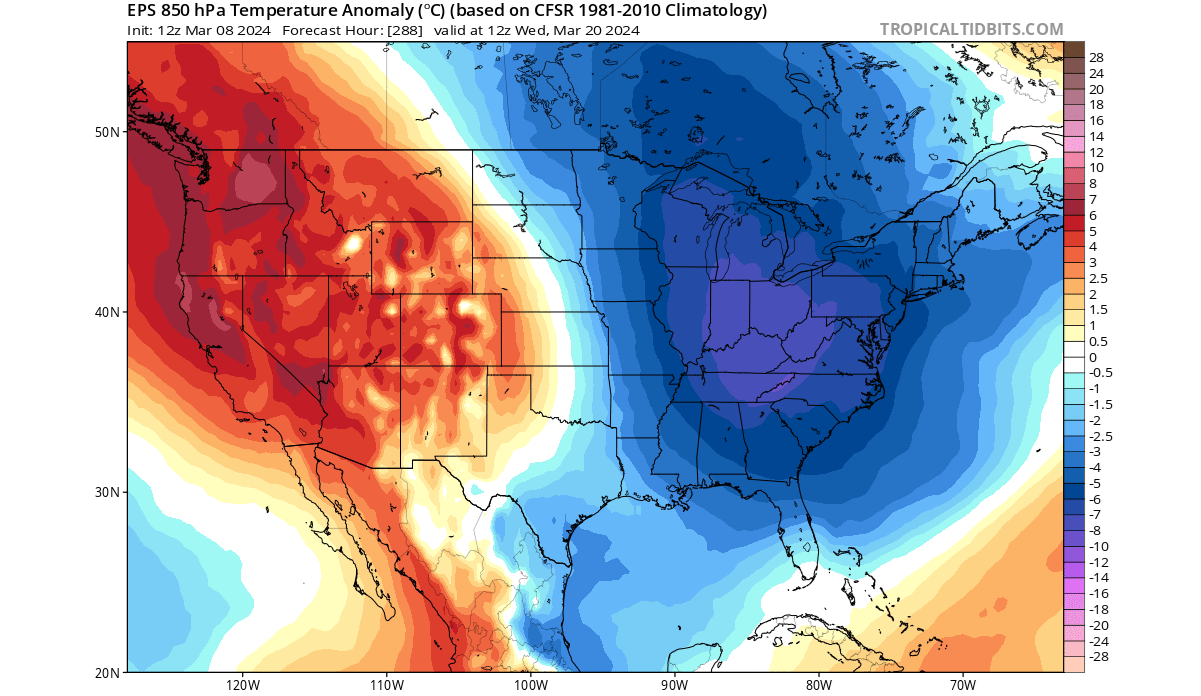
Looking at the pressure anomaly in the lower levels, you can see exactly this pattern, reflecting the changes in the stratosphere. A high-pressure ridge rises over the western United States and Canada, while we see two separate low-pressure cores, just like in the higher altitudes.
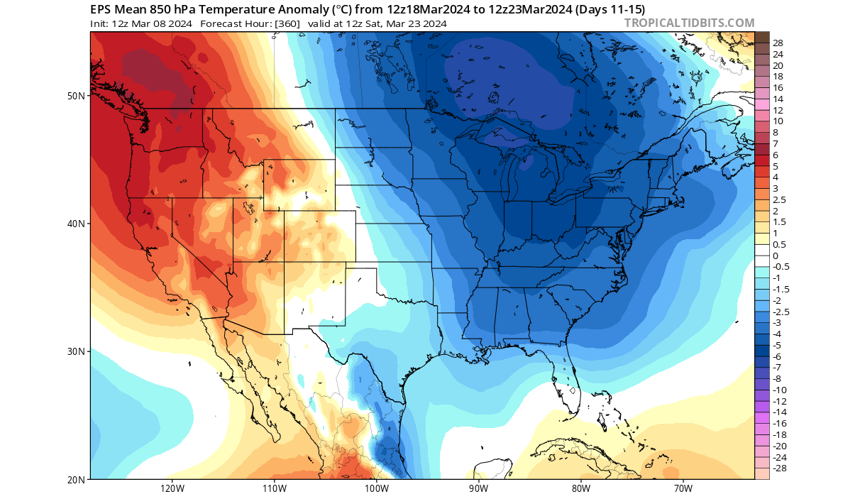
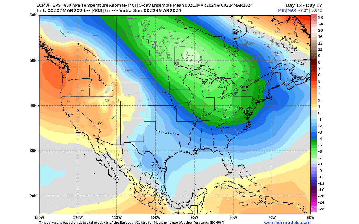
Looking at the temperature forecast for this period, you can see the colder-than-normal air spreading across much of the northern and eastern United States and southeastern Canada. The high-pressure ridge will bring warmer temperatures into the western United States.
In these forecast ranges, we like to look at anomalies to see what the forecast trend is (warmer/colder than normal). Below is the ensemble forecast for morning surface temperatures across the United States, and it shows low temperatures around freezing for much of the northern United States, into the upper Midwest and the northeast.
Looking back at anomalies, it can show us where the main path will be for the colder/cooler air from the north. As you can see in the image below, the bulk of the cooler, northerly air will be affecting the eastern United States and parts of the north.
We are already in the spring season, but March is always the transitional period between winter and spring. So when we see cold air anomalies, we can still expect to see some snowfall. In this extended range forecast, it’s hard to have any accuracy with snowfall, but we can look at an example forecast for the next 16 days to see what the main zone, at least one that can still expect to see some snow.
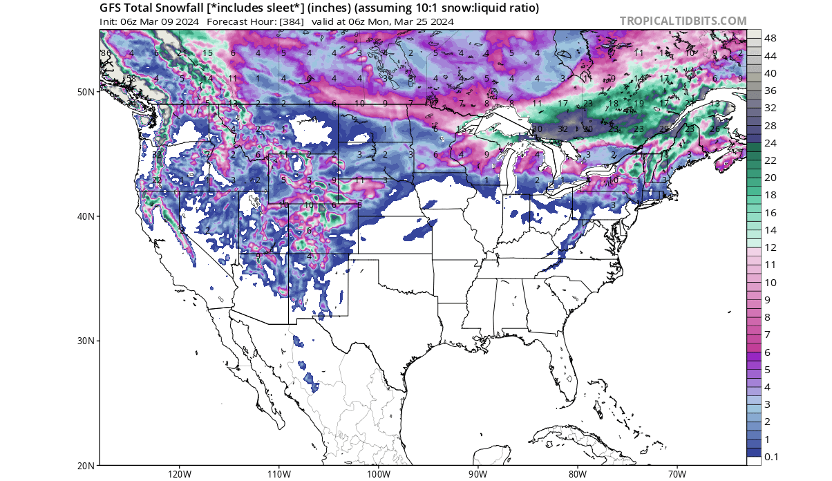
The image below is a snowfall forecast from the GFS model, and can be used as an example solution of the upcoming weather pattern changes. With the colder air coming from the north, you can see snowfall across the northern United States, around the Great Lakes, and across the Mid-Atlantic and New England.
Having a cold air anomaly and snowfall across the United States in March is not unusual. But how long is this weather pattern expected to last?
A DISRUPTED SPRING CONTINUES?
First, we have to add that the following forecast maps are just the latest trends. Despite the success these forecasts had in previous months, these are not fixed weather scenarios. Images are from weathermodels.com, using a commercial license.
Before we go into the forecast, we have to look at the forecast from two weeks ago. Why? Because it was very much on point. The image below covers the last third of March and was issued on 22nd February, so over 2 weeks ago. It already hinted at a cooler trend in the second half of March, over a month in advance.
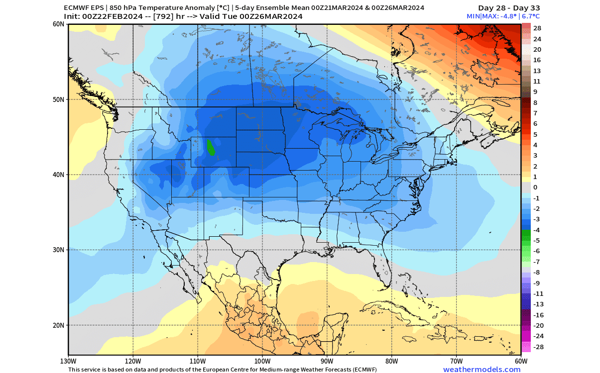
This is a testament to how these weekly trend forecasts are actually usable for upcoming weather patterns. Of course, they must never be taken literally, but are always used to see trends in the pressure/temperature forecast on a larger scale.
Going into the latest extended forecast, the weather pattern over North America looks to be stable. The high-pressure anomalies over Greenland and western Canada help to lock the low-pressure area over the eastern United States and eastern Canada.
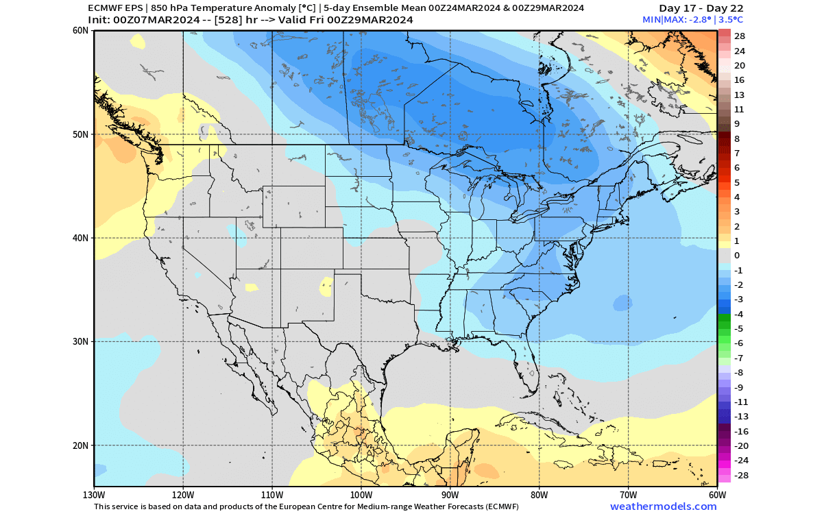
The temperature forecast below is the latest version of the forecast we showed you above from two weeks ago. You can still see the bulk of the cold anomalies over the northern United States, across the Midwest, and into the eastern United States.
Looking into the final week of March, the cold anomaly is expected to weaken as the weather patterns undergo a new cycle, but it still takes some time for the colder airmass to fully move out. That still leaves a cold anomaly trend in the forecast.
Since these are quite substantial cold anomalies, we can look at the snowfall trends for this period. Below is the total snowfall for the last third of March, and you can see snowfall potential is largest across the rockies and other higher elevations in the western United States. That is quite normal for March.
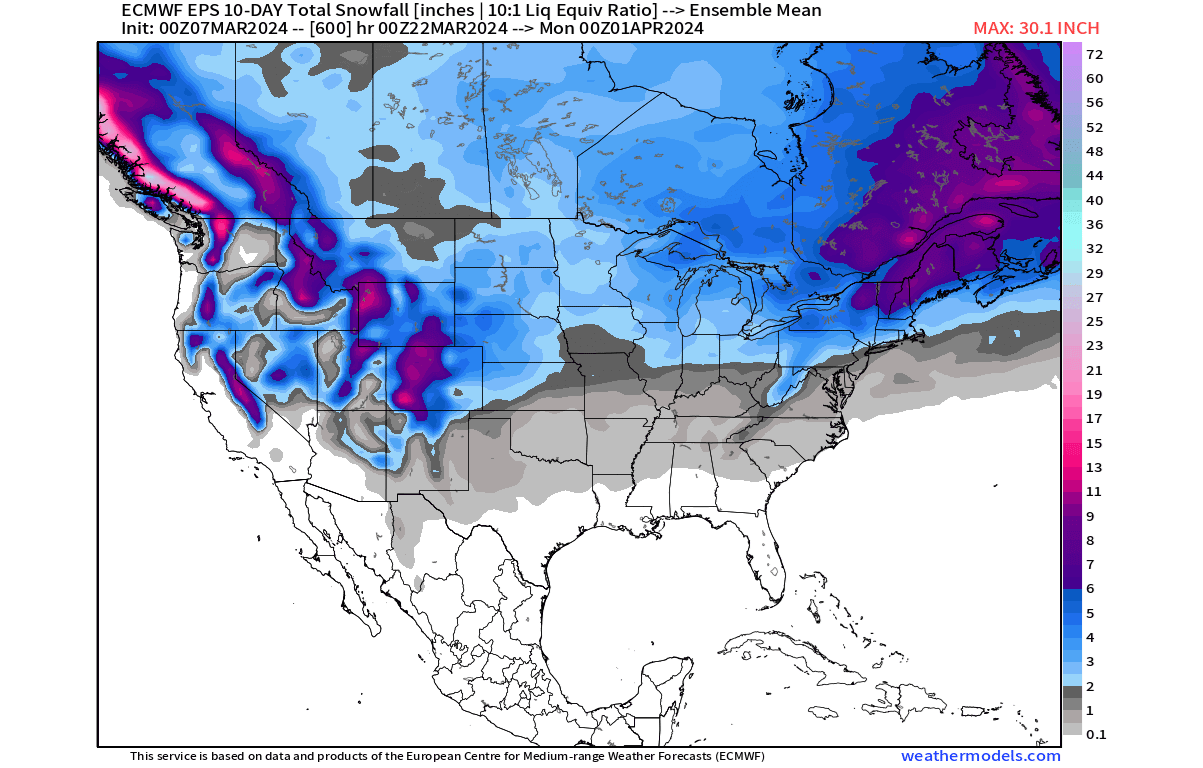
But looking over the north and east of the United States, you can see snowfall potential across the upper Midwest, around the Great Lakes, and over the northeastern United States. These areas are far enough to the north to still receive cold enough air in these weather patterns that can result in spring snowfall.
These forecast maps were provided by weathermodels.com, using a commercial forecaster license.
We will keep you updated on the global weather pattern development, so don’t forget to bookmark our page. Also, if you have seen this article in the Google App (Discover) feed, click the like button (♥) there to see more of our forecasts and our latest articles on weather and nature in general.
Learn more: