Weather patterns are changing again, this time with the help of the final warming event in the Stratosphere. The latest forecast shows a cooler and unsettled weather pattern to develop over the United States in March, while Europe is forecast to continue a similar weather pattern as in the past weeks.
There are always many factors that impact how the weather will be tomorrow. But as we slowly shift from winter into spring, there are many seasonal forces at play that together can create very unique weather patterns.
As you will see, the stratospheric polar vortex is in its final days and will slowly disappear until next winter. This event is called Final Warming, as the temperatures in the stratosphere do not drop again until next autumn. This often has an important impact on the weather patterns going into spring.
WEATHER PATTERNS AND THE POLAR VORTEX
We often talk about the polar vortex, and there are many explanations out there of what it actually is. In simple terms, it is just a name that describes the broad winter circulation over the northern (and southern) hemispheres.
Below is the latest 3D image analysis of the polar vortex. The vertical axis is enhanced for better visual presentation. You can see the structure of the polar vortex, connecting down from the stratosphere to the lower levels and the pressure systems.
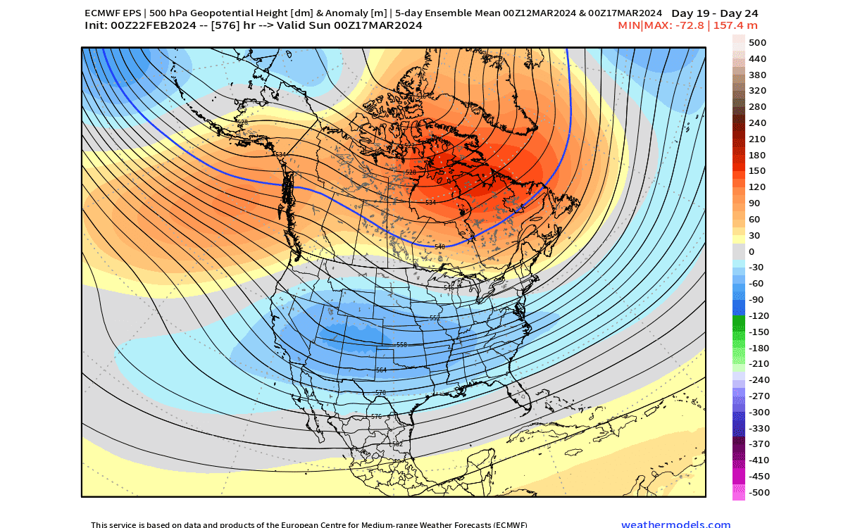
You can see that currently, the polar vortex is in a very uneven shape, being compressed and oval instead of nicely circular and positioned over the north pole. In the lower levels, we can even see a smaller separate area over Greenland and the Canadian archipelago.
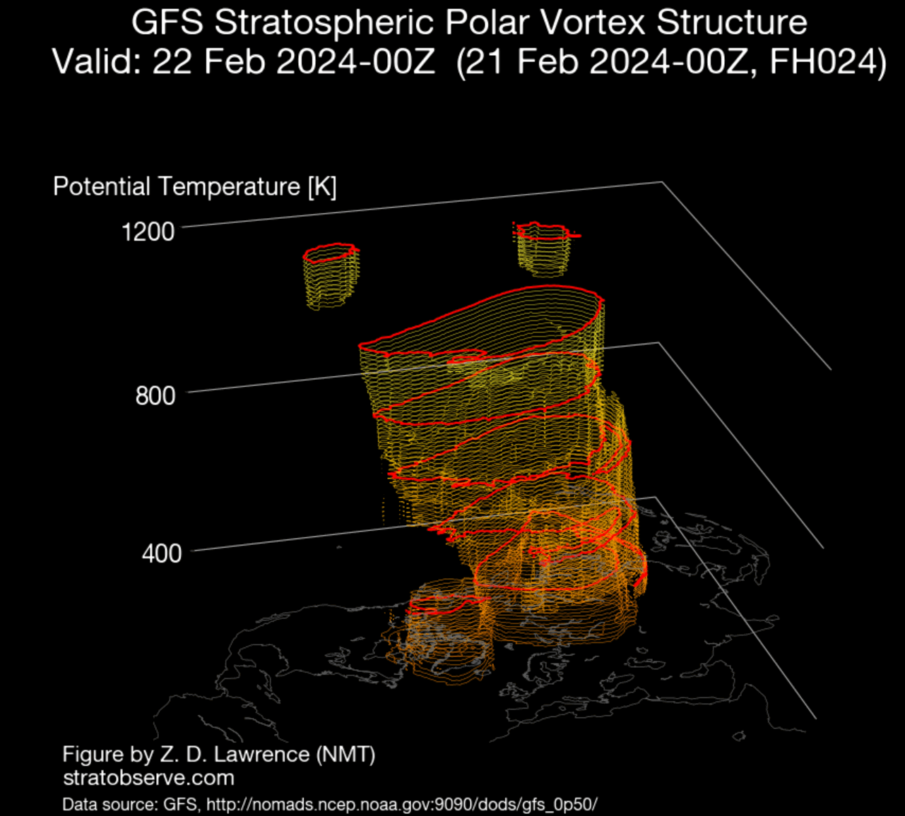
You can see that currently, the polar vortex is in a very uneven shape. It looks compressed and oval instead of nicely circular and positioned over the north pole.
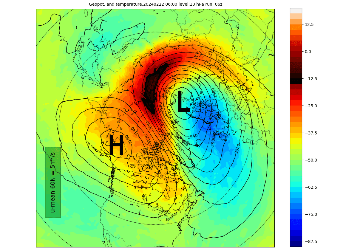
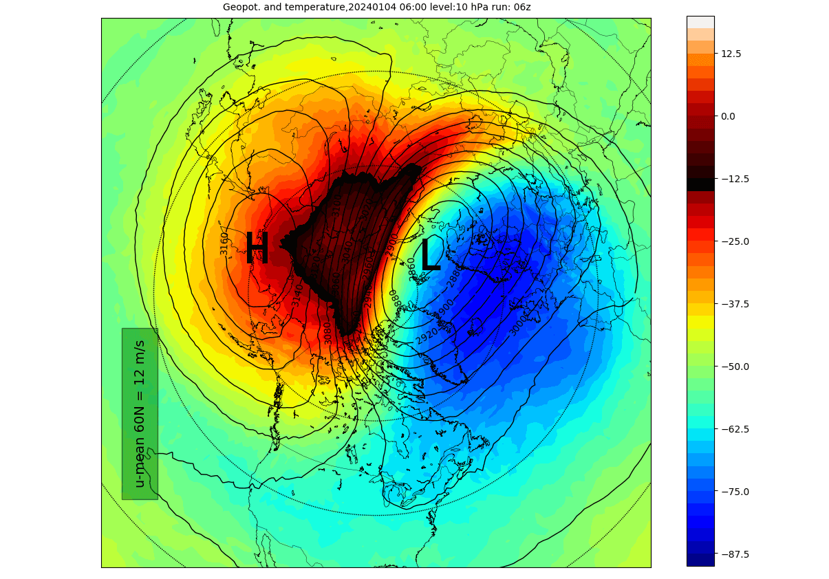
Below is the latest analysis of the stratosphere at the 10mb level, which is at around 30km (18.5miles) altitude. You can see the polar vortex as the low-pressure system (L) and the strong stratospheric high-pressure area (H). That high is causing the deformation of the polar vortex, along with the warming wave seen wrapping around it.
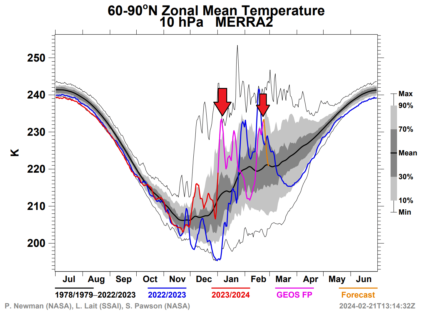
This is not the first such event this season. In the image below from NASA data, you can see the temperature graph of the mid-stratosphere. You can see temperature spikes in early January, which was the previous strong warming event. The second arrow is the current (smaller) warming event.
Below, you can see the state of the stratosphere at the 10mb level during the first temperature spike in early January. You can see a strong high-pressure system pushing the polar vortex out of the pole, with a significant stratospheric warming anomaly helping to further weaken the polar vortex.
This helped to greatly destabilize the polar vortex circulation, also disrupting the weather patterns at the surface with some delay. For this reason, we monitor the state of the polar vortex, as it can have a profound impact on our daily weather.
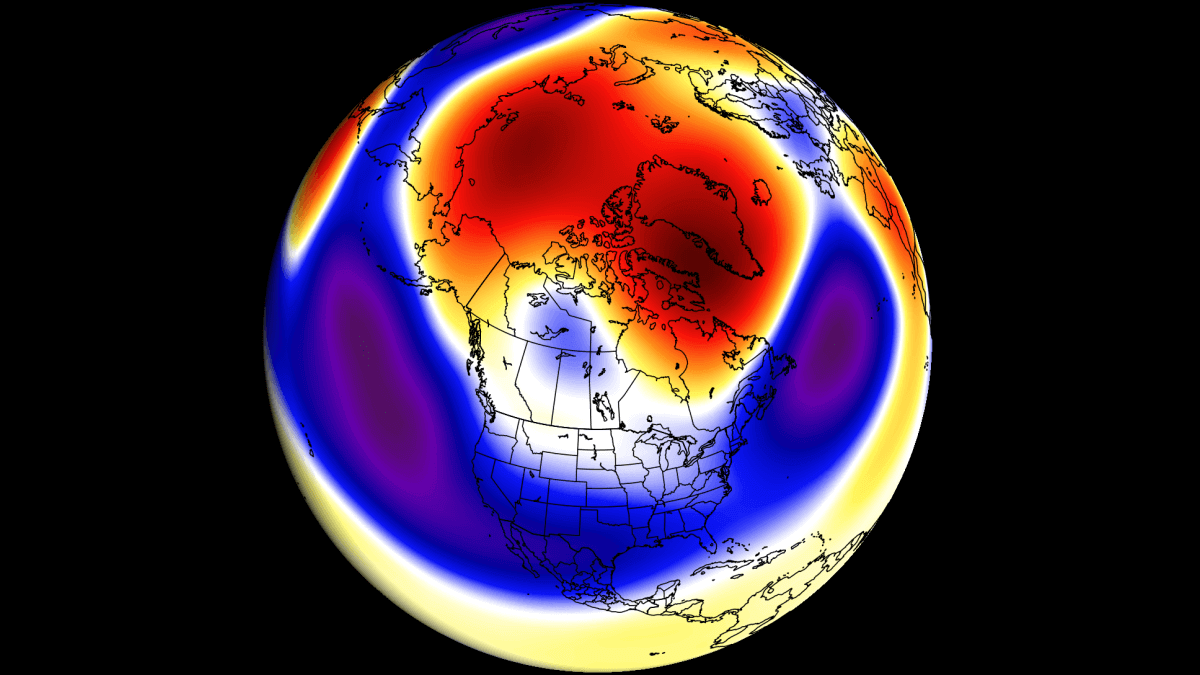
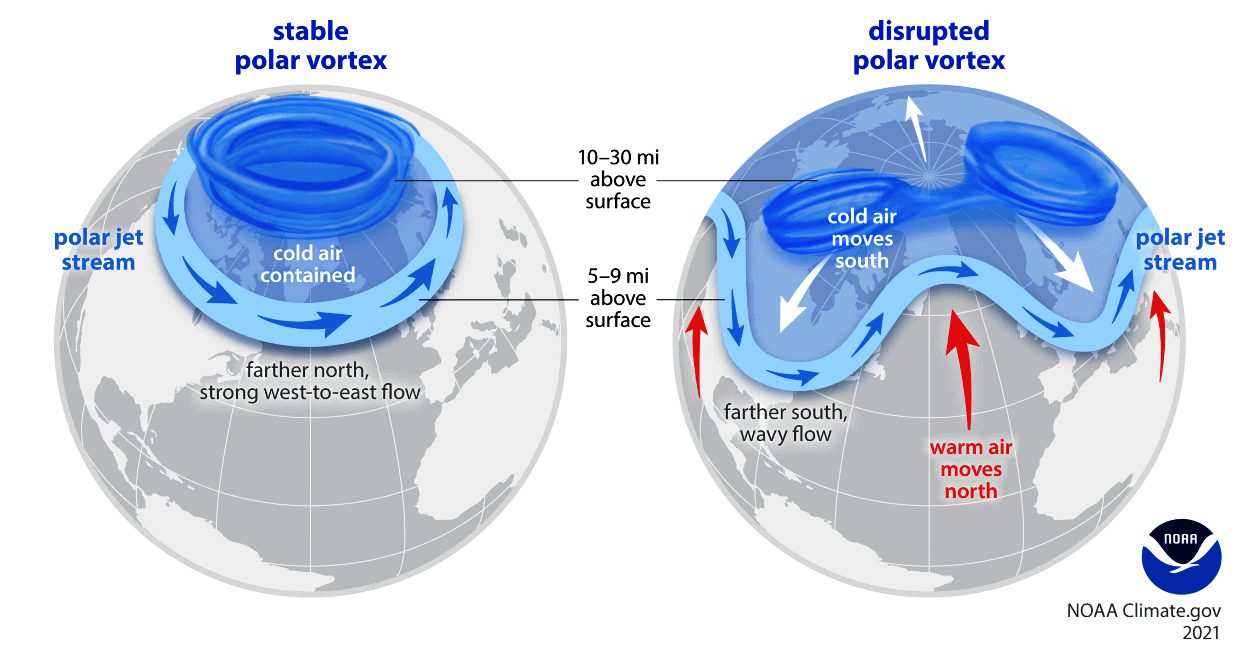
When the polar vortex is strong/stable, it usually means strong polar circulation and jet stream. This locks the colder air into the Arctic Circle, creating milder conditions for most of the United States.
In contrast, a weak/disrupted polar vortex weakens the jet stream pattern. As a result, the colder air is harder to contain and can escape more freely from the polar regions into the United States or Europe. Image by NOAA.
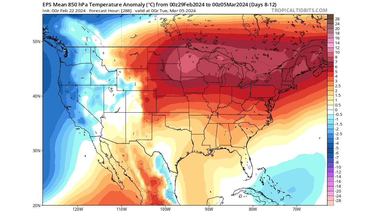
This is exactly what happened after the early January warming event. Below is the temperature anomaly for mid-January, and you can see a significant cold weather pattern that has unfolded. The unusually cold air has spread from the northern United States down into the central, southern, and much of the eastern parts of the country.
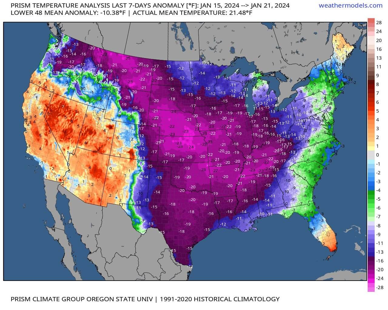
This strong pattern change was connected to the stratospheric activity and was a very nice example of how the polar vortex disruption can lead to changes in our daily weather.
The reason we wanted to show you this January event is to highlight the importance that the polar vortex has and how it can exchange its strong dynamics with the weather that we feel daily. In the next image below, you can nicely see these “exchanges” between the stratosphere and the lower levels.
Below, you can see the pressure anomalies in the atmosphere, from the ground up to around 50km (31miles) altitude, all the way back to late December. You can see the first stratospheric warming even in early January (red box), connecting all the way down to the surface.

In the blue box, you can see the current warming, not having such a strong surface connection, which we will look at more closely. But in the white box is the forecast part of the image. There, you can see another strong anomaly developing, which can have an impact on weather development in early Spring.
First, we will look at the upcoming weather patterns to see their connection to stratospheric disruption. Then, we will look at a more significant stratospheric anomaly developing for early March and its potential weather influence on early Spring.
POLAR VORTEX ABOVE AND BELOW
We know that the upper polar vortex is undergoing a disruption and a warming spike at the moment. But the previous image above does not show a strong surface connection.
Looking below, we see the forecast of the lower stratosphere at around 20km/12.5miles altitude in the coming days. Here, we do not see a strong high-pressure area or a significant warming wave. We do see a warm area, but the overall shape of the polar vortex is stable and not that disrupted.

But notice the “arm” extending away from the main polar vortex at this altitude, under the warm anomaly area. This does signify a potential low-pressure area to move over the United States and Canada.
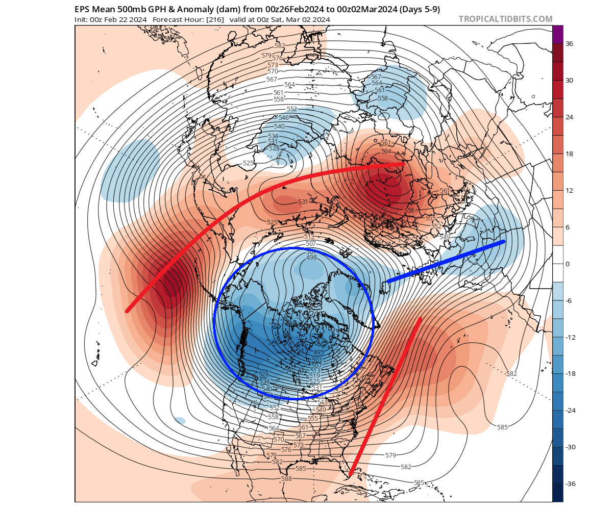
Looking at the latest pressure anomaly forecast for the next few days, we can see a very disrupted weather pattern. A low-pressure area will sit over northern Canada and Greenland, with a cut-off extension into western Europe. This large circular area is the lower core of the polar vortex, and you can see is extending also into the northern United States.
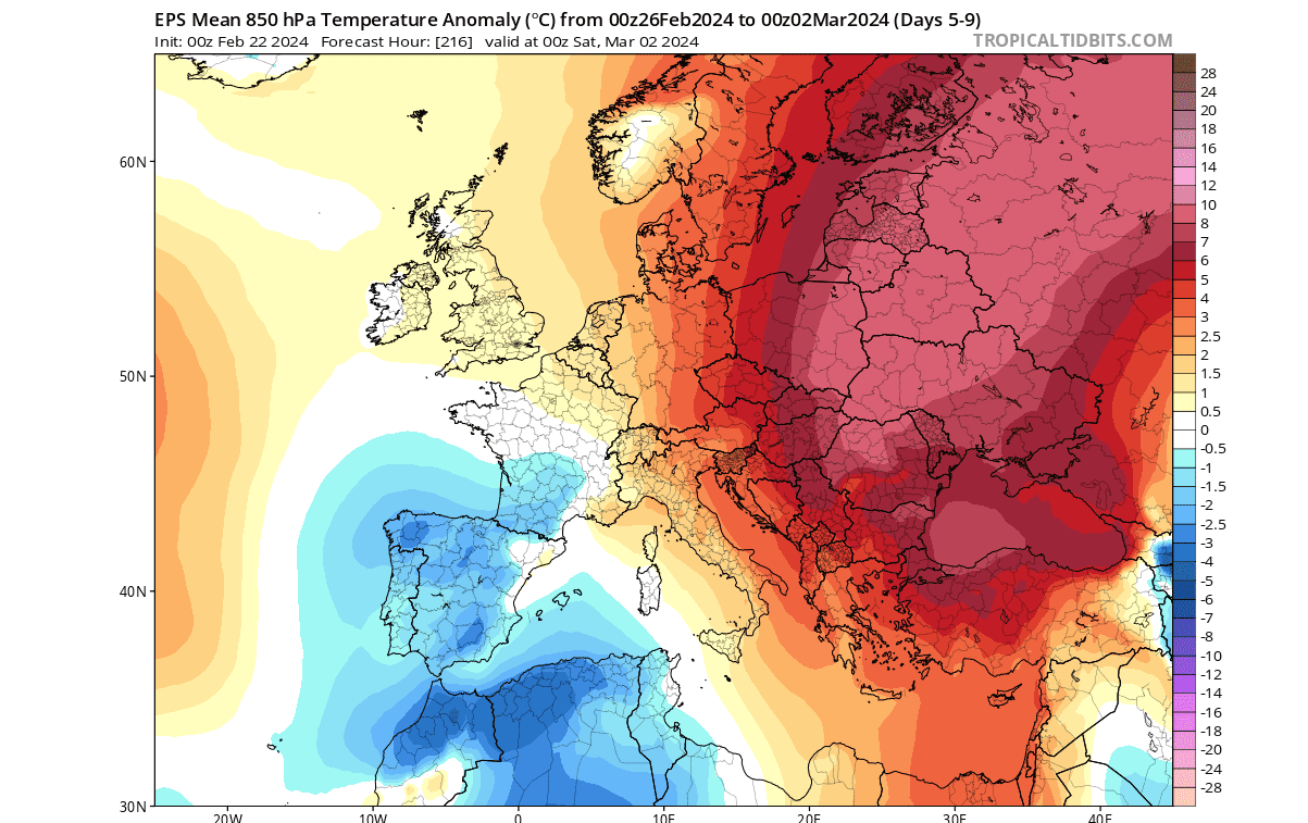
Looking quickly at Europe first, we generally see warmer than normal weather over much of the continent, similar to the current pattern. The exception is Western Europe, which will be under the influence of the separated low-pressure area, which we marked in the pressure anomaly above.
The situation over the United States will be more complex. Below, you can see the low-pressure “arm” extending from the main polar vortex core. The forecast is for mid-next week, and shows a low-pressure area over the western United States, which is expected to move over the country. A. ridge rises over the east in response, bringing warmer weather to the east and the northeast.
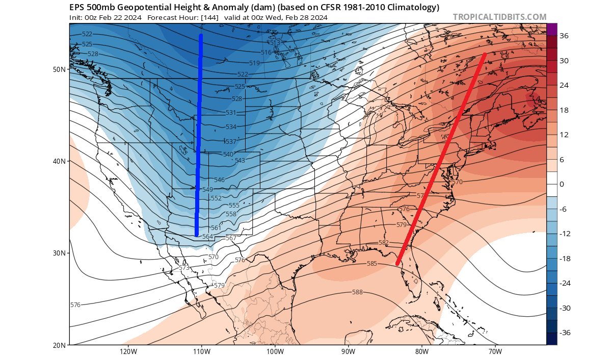
Looking at the temperature forecast for this period, you can see the colder-than-normal air spreading across much of the western and northern United States and southern Canada. The high-pressure ridge will bring warmer temperatures into the eastern United States.
Looking at the precipitation anomalies for this period, you can see more rainfall over the western United States, apart from northern California. More precipitation is also forecast over the midwest as the low-pressure area moves over, along with some snowfall in the upper Midwest.

Less precipitation is expected over the northern and southern plains, over the southern United States, and the northeast.
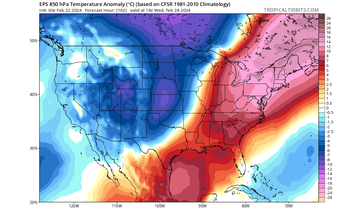
Temperatures over the east are expected to drop as the low-pressure area moves over later next week, as seen in the image below. But the cooling won’t be that significant, as this polar vortex “arm” will weaken on its way. And behind it, you can see a new warm wave developing over the northern United States.
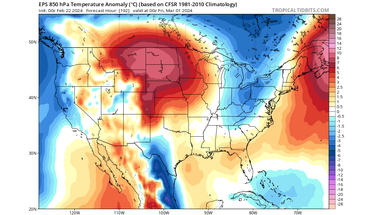
Looking further ahead into early March, you can see this warm anomaly extending over much of the northern, central, and eastern United States. This is due to the high-pressure area expanding over the United States as the arm of the polar vortex moves out.
But while spring looks to arrive early in the United States with warmer weather, there is one more process that usually unfolds in the stratosphere every year. That is the Final Warming, and it marks the end of the polar vortex until the winter.
It is usually different than a strong mid-winter stratospheric warming event. As the Sun gets higher in March and sends more energy and warmth to the Northern Hemisphere, the temperature difference between the North Pole and the tropics reduces.
This temperature difference is what drives the polar vortex to form in the first place. So, as we head into spring, the time is running out for the polar vortex. The main question is only if it goes out slowly or with a bang. That can have important implications for weather development.
FINAL STRATOSPHERIC WARMING
This event called the final warming, just marks the breakdown of the polar vortex with no point of return until the next cold weather season.
The forecast graph below shows the wind speed of the polar vortex in the stratosphere. You can see a rapid wind speed reduction of the polar vortex in early March. Westerly winds are directly related to the power and state of the polar vortex, so a reduction or even a reverse (negative winds) shows a complete breakdown. Image by Tomer Burg
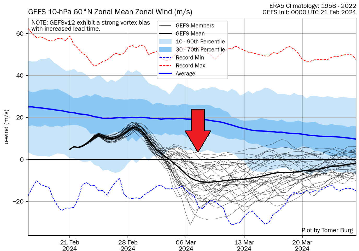
As you can see, the main line of the forecast does not rise again above 0, which means the winds are forecast to stay reversed. That also means the polar vortex is unable to reform and is likely to stay gone until the next large cooling begins this autumn.
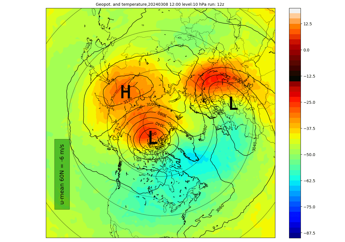
Below, you can see the state of the stratosphere at the 10mb level (30km/18.5miles altitude) at that time. The polar vortex, as such, is no more split into two smaller areas of lower pressure, and the cold core is more or less gone. There is no real organization left in the stratosphere, with the circulation in its final stages of the season.
In the next image, from weathermodels, you can see the pressure anomaly at the same 10mb level. Most of the mid-stratosphere is under much higher pressure than normal, with low-pressure areas being small and scattered.

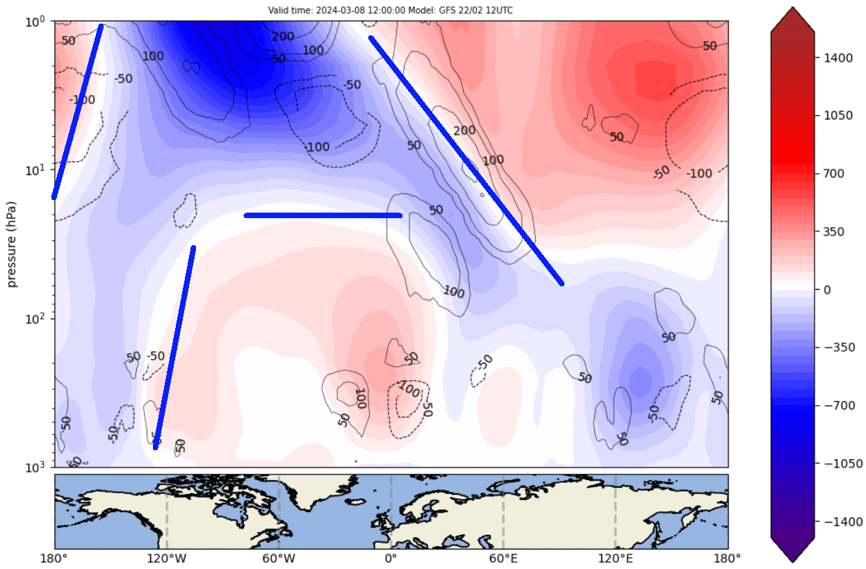
But how can this have an impact on our weather? The easiest way to track that is by simply looking at the vertical pressure anomalies. You can see that the remaining low-pressure zone in the stratosphere is forecast to connect down into the North Pacific. image by weatheriscool.com
And in this case, it can very well happen that the anomaly from the stratosphere can actually help to strengthen a certain weather pattern, that evolves into a blocking of the polar regions, bringing unsettled spring weather into the United States and Europe.
A low-pressure area over the North Pacific and western United States can help to develop a high-pressure area downstream. That high-pressure area can grow and move further up north, disrupting the jet stream and bringing unsettled weather to the United States and Europe.
You can see the start of this process in the forecast below for the early day of March. The residual low-pressure area of the Polar Vortex helps to build a strong ridge over the eastern United States and Canada. But as that ridge moves further up north, a low-pressure area takes its place, along with cooler and unsettled weather.

But this is just the start of this process. We produced a video animation below that shows the temperature forecast trends for March and early April by the ECMWF extended forecast. You can see this process in motion as the temperatures drop across the entire United States.
We will further explain this weather process below, with the latest forecast graphics for the next few weeks.
A DISRUPTED SPRING START
At this point, we have to add that the following forecast maps are just the latest trends. Despite the success these forecasts had in previous months, these are not fixed weather scenarios. Images are from weathermodels.com, using a commercial license.
Looking at the pressure pattern around mid-March, you can see the low-pressure anomaly expanding across the United States. The blocking high has moved over Greenland, joining with the Canadian high-pressure area. This is the exact weather pattern evolution that is typical for late El Nino winters and following stratospheric disruptions.
The temperature anomaly for the same period shows the expected lower temperatures across the United States, focused more on the west but also moving into the eastern United States as the low-pressure area expands. At this point, this does not look like a strong cold event, but it does move in the right direction for a proper early spring cold to follow.
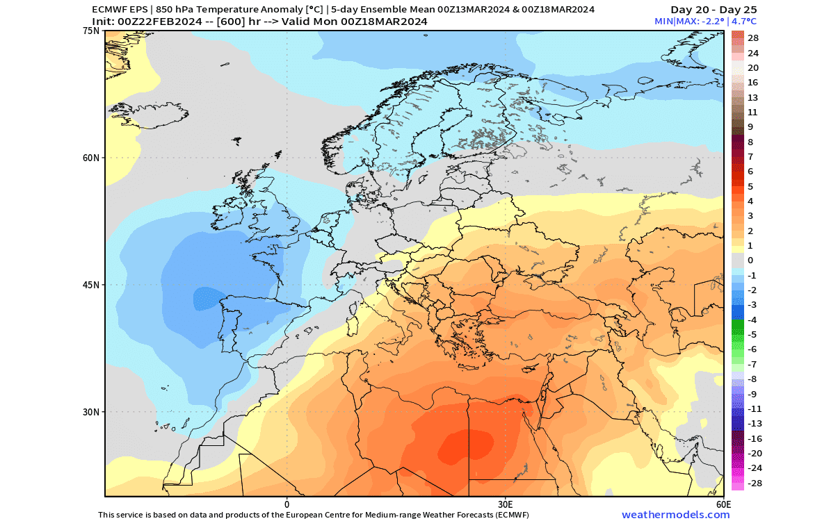
Looking quickly at Europe in this period, you can see a low-pressure area over the west, displaced by the high-pressure area over Greenland and partially the North Atlantic. Such a cyclonic area can affect most of western and central Europe with unsettled weather.

The temperature forecast also shows that a strong cold anomaly is not expected for now, as the winds are mostly southerly over the central parts. Cooler weather is expected over the west and north due to more northerly to northeasterly winds.
THE WEATHER PATTERN DEEPENS
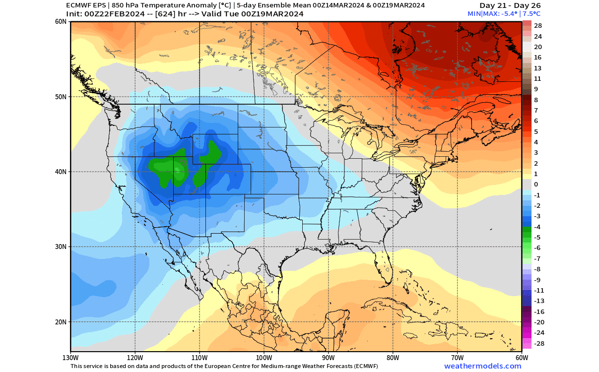
Going deeper into March, the weather pattern over North America evolves further. In the pressure forecast below, you can see a semi-persistent high-pressure zone over much of Alaska, Canada, and over Greenland. This gives great support for low-pressure areas to remain over the United States, but focused slightly more to the east.

The temperature forecast for this period shows the bulk of the cold anomalies over the northern United States and the Midwest, also covering much of the eastern United States. This pattern overall, is usually what brings proper cold air into the northern and central parts of the United States, and sometimes even spring snow over the Northeast.
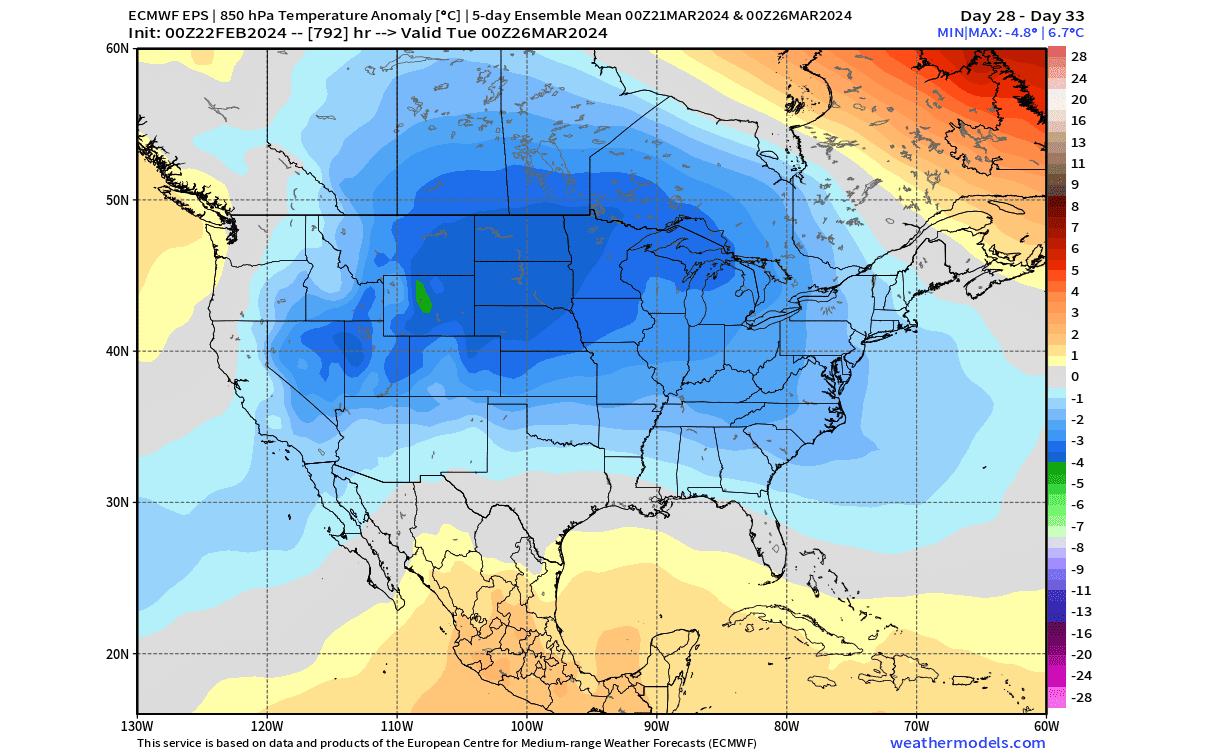
Looking at the precipitation for this period, we can see increased precipitation over the Midwest and the eastern United States. This reflects the low-pressure zone moving from the western over to the eastern United States in this period, bringing along more precipitation.

Depending on when the colder air comes down, if moisture is available, this can bring an early spring snowfall event across the upper Midwest and parts of the Northeast.
These forecast maps were provided by weathermodels.com, using a commercial forecaster license.
We will keep you updated on the global weather pattern development, so don’t forget to bookmark our page. Also, if you have seen this article in the Google App (Discover) feed, click the like button (♥) there to see more of our forecasts and our latest articles on weather and nature in general.
Learn more: