A winter storm has developed over the northern United States on Wednesday with a cold blast spread in the wake of the Arctic front. Winter weather is forecast to spread across the Northeast, while the front with severe storms and tornado potential races for the Mid-Atlantic and East Coast on Christmas Eve.
A significant blizzard has developed across parts of the northern United States through Wednesday evening and night hours, now gradually vanishing towards the Great Lakes on Thursday early morning.
A significant outbreak of Arctic cold air mass is expected to spread towards the East Coast and Northeast tonight through Christmas morning.
The Arctic front, associated with this winter storm is forecast to continue east across the Southeast United States today, reaching the East Coast and the Mid-Atlantic region this Christmas Eve.
Severe weather, including organized supercell storms with potential for damaging winds and fast-moving tornadoes, will continue along the moving Arctic front. An ENHANCED RISK has been issued for the Mid-Atlantic region.
While mostly the eastern half of the country should be affected by this winter storm, the current snow coverage over the States does suggest that a good part of the United States should experience White Christmas Eve and morning.
WINTER STORM DEVELOPS FROM THE NORTH
A new winter storm is emerging into the eastern United States, with a well-defined and sharp cold front moving across the Dixie Alley (Southeast US) this Thursday morning. Much colder Arctic air mass has spread in the front’s wake from Canada, spread across the Great Plains and the Midwest, advancing east towards the Ohio Valley.
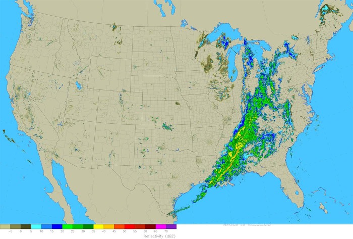
Both satellite and radar imagery suggests an organized line of storms, including severe storms with supercells, is accompanied by the moving Arctic front. Heavy rain, severe winds, and tornado threat will gradually increase along the front later today into Christmas Eve.
The core of this winter storm is moving over the Dakotas and Minnesota this Thursday morning and Arctic cold temperatures are being observed. Near zero to more than 10 °F below zero temperatures (-23 °C) are reported from North Dakota and northern Minnesota.
But the real feel of the cold is even stronger, as very windy conditions remain.
Much colder temperatures have already reach Texas and the Mississippi Valley, now entering the Ohio Valley on this Thursday early morning.
Extremely low windchill has developed across the eastern Dakotas, Minnesota, and northern Iowa, in a combination with strong northerlies with these Arctic cold air mass. Locally, the windchill is being pushed even below -30 °F (-35 °C)!
There was also a blizzard warning across eastern Dakotas and Iowa last night, with a heavy snow band developed with strong to locally severe northwesterly winds creating near-zero visibility conditions due to blowing snow.
This Arctic trough will bring very strong temperature contrast across the cold front, followed by a massive Arctic blast in its wake. While ahead of the front, an impressive warmth will develop into the Mid-Atlantic coast and towards New England.
The Northeast United States will experience snowfall from Christmas Eve into Christmas Day, so it definitely looks like this last-minute winter storm forecast to hit the East Coast will bring fresh snow.
Here is a brief overview of the probability of a White Christmas across the country this year.
WHITE CHRISTMAS OUTLOOK 2020
The snow coverage for Christmas day across the United States looks like it will follow the historical probabilities this year. The best chances are seen over the northern half of the country, while there are no chances for a white Christmas across the South.
Attached below is the probability of White Christmas 2020 across the United States:
What appears likely is a heavy snow band expected to develop from the Ohio valley further into the Northeast US, delivering a decent snowpack.
But the weather forecast for Christmas Eve across the East Coast definitely needs additional attention, as some dangerous severe weather is shaping up.
Supercell storms, including a few fast-moving tornadoes, will be possible through the evening into Christmas morning hours.
DEEP TROUGH STRENGTHENING TOWARDS THE EAST COAST
The pattern emerging into the United States from Canada indicates a strong upper-level ridge expanded across the western parts of the country, with a strong deep low to its east moving towards the Southeast and the East Coast.
To its east, a powerful blocking high (upper ridge) is in place over the Northwest Atlantic and far eastern Canada. In between the two features, a strong meridional southerly flow has established, pumping the very warm air mass and high moisture into the Mid-Atlantic and New England.
This strong Northwest Atlantic ridge is also responsible for a very significant pattern change over Europe arriving after Christmas, see details below:
The deepening surface low along the East Coast will also give an additional boost to the warm advection ahead of the front, as well as pulling much colder Arctic air mass from Canada in its wake. A high-pressure area develops across the north and western portions of the CONUS.
The Arctic front is incredibly sharp, with a strong temperature change between the Mid-Atlantic coast and areas behind the front across the Midwest and Ohio Valley through this Christmas Eve. Seeing from the white lines, we can feel the general wind flow.
Very strong southerlies will push to the east of the front, pulling a very warm air mass from the Caribbean region and the Bahamas towards the Mid-Atlantic and East Coast, creating a strongly unstable environment.
This environment will become conducive for convective storms along the fast-moving Arctic front, likely supporting supercell storms with damaging winds, including the potential for a few tornadoes across the eastern Carolinas and surrounding areas of the Mid-Atlantic coast.
DEEP CORE MOVES ACROSS MID-ATLANTIC THROUGH CHRISTMAS MORNING
Overnight to Christmas Day and morning, the winter storm advances further east over the Mid-Atlantic region, and winter weather is forecast to develop along and the west-northwest of the Arctic front. The core of the storm will be impressively deep, making a strong dipole pattern against the powerful upper-level ridge to its northeast over the Northwest Atlantic.
Through Christmas Day, the overall pattern improves further west across the Contiguous United States. While a new deep Pacific storm pushes into the Northwest.
The surface low, associated with this winter storm, will continue deepening into Christmas morning while gradually moving north-northeast across the Northeast US into southeast Canada. A strong pressure gradient on its front edge will support additional strong warm southerlies into New England.
The temperature picture will still be impressive – notice a huge contrast between both sides of the Arctic front. The very cold air mass will be gradually spreading into the Southeast and the Mid-Atlantic coast, as well as towards Florida.
While the pumping moisture and much warmer air mass ahead of the front will remain significant. Strong snow melting will be underway across New England, Nova Scotia, and surroundings through Christmas Day.
During the afternoon and Friday evening hours, the Arctic front will push further east-northeast, so the cold air mass will also reach the Northeast. But strong warm advection continues into northeast New England, Nova Scotia, and extreme southeast Canada.
Notice also a much warmer air mass advancing north over the south-central Plains further west, and across the Rockies. In response to the strengthening high-pressure system over the western CONUS.
EAST COAST TORNADOES ON CHRISTMAS EVE
The rather widespread strongly convective line will develop along the front spreading into the East Coast through Christmas Eve, with embedded severe storms. The arrival of the front into the Mid-Atlantic coast is expected through Christmas Eve.
Expect intense rainfall, locally some hail, and especially severe damaging winds and possibly tornadoes.
According to the Storm Prediction Center (SPC), there is enhanced risk of 10 percent (10 %) probability of tornadoes across the Carolinas and the Mid-Alantic region through Christmas Eve.
Mid-Atlantic region into Southeast US
Late-evening water-vapor imagery depicts an expanding/thickening band of cloudiness across the Arklatex region, indicative of increasing large-scale ascent ahead of a strong short-wave trough. Intense mid-level height falls will spread across the Gulf States/TN Valley region during the day as 130kt 500 mbar speed max translates across northern AL into the southern Appalachians by 25/00z.
While the surface reflection in response to this feature will not be particularly deep, a surface low should track north-northeast from GA into the eastern WV Panhandle by early evening. As this occurs, low-level trajectories will become more favorable for Atlantic moisture to advance inland across Coastal Carolinas as a warm front lifts to near the VA/NC border at 25/00z, then into the Delmarva later in the evening. This warm sector advancement will allow for modest destabilization that will support robust updrafts ahead of the surging cold front.
Early in the period, a frontal squall line should be ongoing from AL to extreme southeast LA. This activity may be severe at daybreak, but higher buoyancy will be noted south of the FL Panhandle which may ultimately lead to the strongest storms gradually focusing offshore with time. However, by mid-late afternoon, instability should improve markedly along the SC/NC Coast as intense southerly low-level flow strengthens ahead of the short wave.
Forecast soundings depict 1km flow on the order of 60kt with MUCAPE in excess of 1000 J/kg at ILM by evening. Intense shear and modest surface-based buoyancy suggest there is a concern for tornadoes with supercells later this afternoon/evening. The latest high res guidance supports a considerable amount of pre-frontal warm-advection convection with supercell structures spreading inland by 21z. Otherwise, some tornado threat will be noted with embedded circulations along the frontal squall line. Damaging winds are also expected with the linear MCS as it spreads east.
Overnight into Christmas morning, the front continues east, ejecting into the Atlantic ocean off the coast of Carolinas. Further north it is still over land, moving across New Jersey and New York towards the east. Very heavy rainfall is expected through Christmas morning there, spreading across Long Island.
Through the late morning into afternoon hours, the front continues further east and finally ejects to the Atlantic, while heavy rain reaches southern New England towards the evening hours on Christmas day.
Both New York and Boston cities could be hit by very heavy rain, local flooding, and possibly severe damaging winds.
FLOODING THREAT FOR THE MID-ATLANTIC
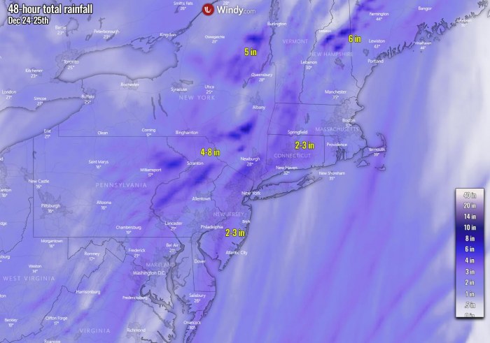
Ahead of the Arctic front racing towards the East, strong southerly winds push a very warm air mass and high moisture with heavy rains into the Mid-Atlantic region and towards New England. As a result, significant snow melting will be ongoing in these areas across the Northeast.
One of the concerns is the amount of rain over the areas which have received up to 40 inches of snow during the winter storm a week ago. That could bring some damage due to a significant weight from the combination of water content due to snow becoming very heavy for the roofs covered in deep snow. Roof collapse could occur in these areas.
And also, rapid snow melting with an additional couple of inches of rain could lead to street and river flooding and landslides locally.
High wind warnings are in effect for the Mid-Atlantic coast towards southern New England, including the major cities New York and Boston.
The attached high-resolution NAM model hints that peak gusts up to about 85 mph are possible. Especially along with the coastal areas on Long Island, New York, and along the southern coast of New England through Christmas Eve.
Widespread tree damage and power outages are very likely to occur along the mid-Atlantic coast and the New England region with this winter storm. Severe winds coming from the Atlantic (east-southeast directions), should increase the risk of coastal flooding in the Northeast as well.
There will also strong winds coming behind the Arctic front, where peak gusts could reach up to around 60-65 mph from Lake Erie across the New York state and towards the southern and central Appalachians. Some wind damage could also occur there.
INTENSE SNOWSTORM FROM OHIO VALLEY INTO THE GREAT LAKES
Another concern is also increasing the potential for a rather localized corridor of heavy snow band to develop with this winter storm. As the surface Arctic front of this winter storm is racing east very fast, it catches with the high moisture so a very heavy snow band develops and results in high snow accumulation.
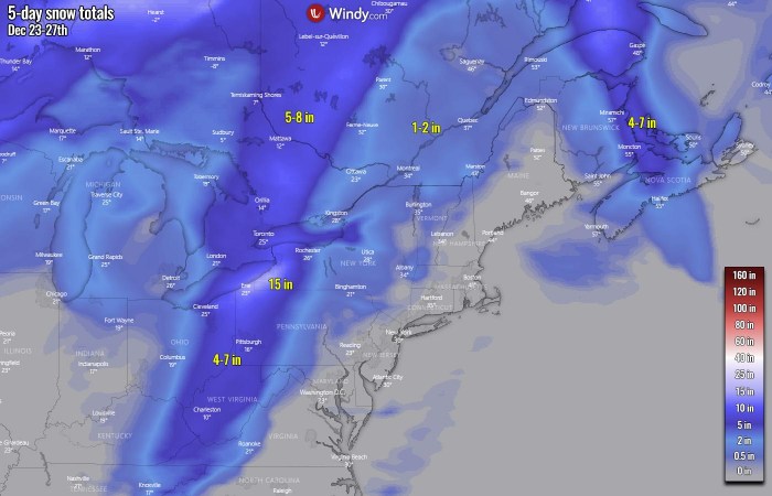
Potentially 4-10 inches of snow could result from eastern Kentucky, West Virginia, eastern Ohio, western Pennsylvania further north across the Great Lakes into southern Ontario, Canada.
Actually, there are also some chances for some freezing rain or sleet along the advancing cold front. Its forward speed is very fast, so it could overtake the mixing air masses while warmth aloft if still not mixed completely.
That introduces a narrow swath of potential ice storm potential somehow to the east of the snow band the chart above is showing. From central Pennsylvania across central New York states towards Montreal. Although chances are low, it could worsen the driving conditions more.
Lake-effect snow* will develop in the storm’s rear side, as strong northwesterly flow establishes over the Great Lakes. This should introduce a quite severe snowstorm on the eastern and southeastern shores of Lake Erie in particular.
Those areas could receive up to 15 inches, potentially close to 20 inches of snow in total until Sunday. Especially as the area should already receive 5+ inches from the heavy snow band developing along the Arctic front on Christmas Eve.
Note: Lake-effect snow develops when a very cold air mass (usually during the Polar/Arctic outbreaks) moves across the warmer lake (Great Lakes in the United States or seas, e.g. Black Sea, Adriatic sea, or Baltic Sea in Europe) water. The layers of air closer to the lake surface are heated up by the warm lake water, picking up moisture/water vapor from the lake and rises up through the colder air advection above. This results in convective squalls and bands of heavy snow. Snow is then deposited on the leeward (downwind) side of the lakes (seas) shores.
Don’t miss a chance for a nice gift for your friends, family or someone special… Weather calendar could be the perfect gift for them – see below:


