Hundreds of trees were uprooted, containers in ports flipped, at least 12 fatalities, and multiple injured residents. That’s the toll of a historic Storm Eunice, the strongest Atlantic cyclone in decades that brought destructive havoc to western Europe on Friday. It will last days to recover, but the weather gives no rest for the region. Yet another, potentially violent windstorm Frankin is expected to blast across Ireland and UK on Sunday night, with hurricane-force winds expected again. Then, a new bomb cyclone follows it on Monday as Polar Vortex above us is unusually intense this winter.
Violent windstorm Eunice ripped across Ireland, Wales, England, the English Channel into northern France, Belgium, the Netherland, and Germany on Friday, leaving several 100.000 homes without power in the UK alone. The transport network has been severely affected as Eunice brought destructive winds up to near 200 km/h (125 mph).
The UK Met Office had a rare Red warning issued, while our forecasters have issued a HIGH RISK for violent winds on Friday. High winds led to school closures, numerous flight cancellations, and caused at least one fatality and a number of injured due to falling trees and flying debris in violent winds.
The Isle of Wight reported a record-breaking wind gust of 122 mph = 196 km/h for England, surpassing the previous record of 118 mph (190 km/h) set in 1979 at Gwennap Head in Cornwall. Gusts from 150-180 km/h were reported from many areas.
Looking at the satellite image this Saturday afternoon, we can see a quite similar pattern is developed as it’s been with the Dudley and Eunice storms a few days ago. Eunice is departing the Baltic region while a large new upper wave disturbance is taking shape over the Atlantic Ocean.
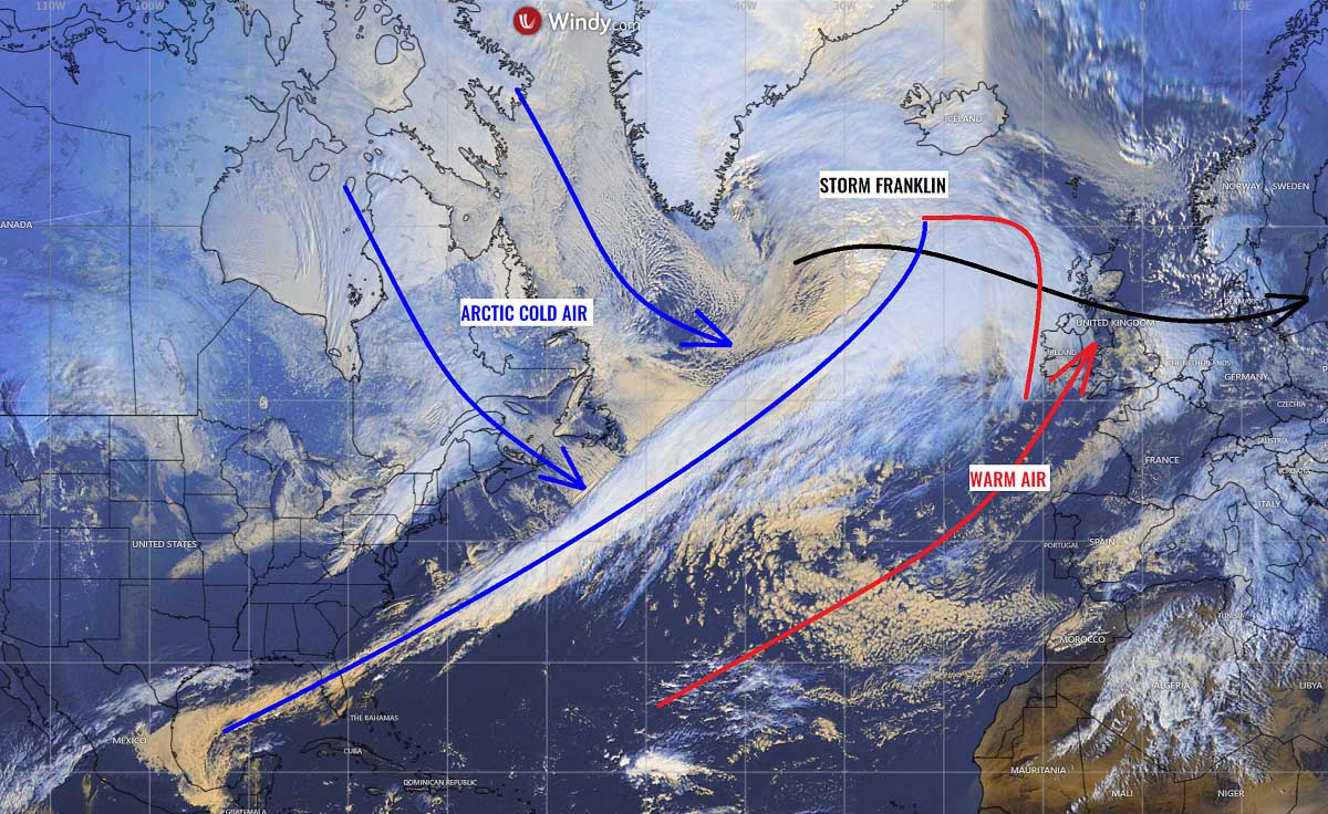
To the north of the front zone, a massive Arctic cold blast is spread from Canada and across the Labrador Sea into the Northwest Atlantic, with this forming wave disturbance well seen by the cloud pattern on its front edge. Meanwhile, much warmer air is being advected towards Europe with the zonal flow to the north of the Azores High.
The analysis of the surface patterns reveals a large depression is organizing south of Greenland, with an extremely long 3000+ km frontal baroclinic zone extending southwest all the way to the Gulf of Mexico. The setup has all conditions in place to become another particularly dangerous weather system for the region.
The NOAA Ocean Prediction Center (OPC) is calling hurricane-force winds developing tonight as the cyclone moves closer to Iceland. The central pressure will fall to about 15-20 mbar by Sunday morning before the low makes a sharp turn southeast and head towards western Europe. Northern Ireland, and western Scotland in particular Sunday night.

This system will be our main focus until Monday morning, as after destructive storm Eunice, the upcoming Franklin will again be a very intense and potentially damaging windstorm for portions of western Europe. Violent, hurricane-force wind gusts to nearly 100 mph are forecast, with a swath of major 15m waves for Ireland, Northern Ireland, and western Scotland through Sunday night.
Below is a quick video overview of the developing Franklin and the bombogenesis over the Atlantic, the first one grazing into western Europe over the next 48 hours, followed by a monster for Iceland on Monday night. The air mass will be rather mild this time, so no significant winter weather is, therefore, forecast. The main threats will be intense rain and wind squalls for the areas affected.
The swath of both of these storms is pretty wide and will strongly impact the marine traffic across the corridor from northwestern Europe to eastern Canada and the Northeast U.S., while we can expect additional tree damage, widespread power outages, and traffic disruptions where the most intense winds will develop.
As it happened with the recent storm Eunice, the very active weather pattern over the North Atlantic is to blame for the development of violent cyclones. These are triggered by the feature that is known as the Polar Vortex. Before we go deeper into the latest forecast regarding storm Franklin and another violent low near Iceland, let’s quickly learn why it is important to understand the background of the Polar Vortex.
THE POLAR VORTEX THAT DRIVES THESE EVENTS
If we take a look at how our atmosphere is made, there are six layers that are rounding the Earth. Most of the weather dynamics for our lives occur in the lowest two layers, which are known as the troposphere and the stratosphere layers.
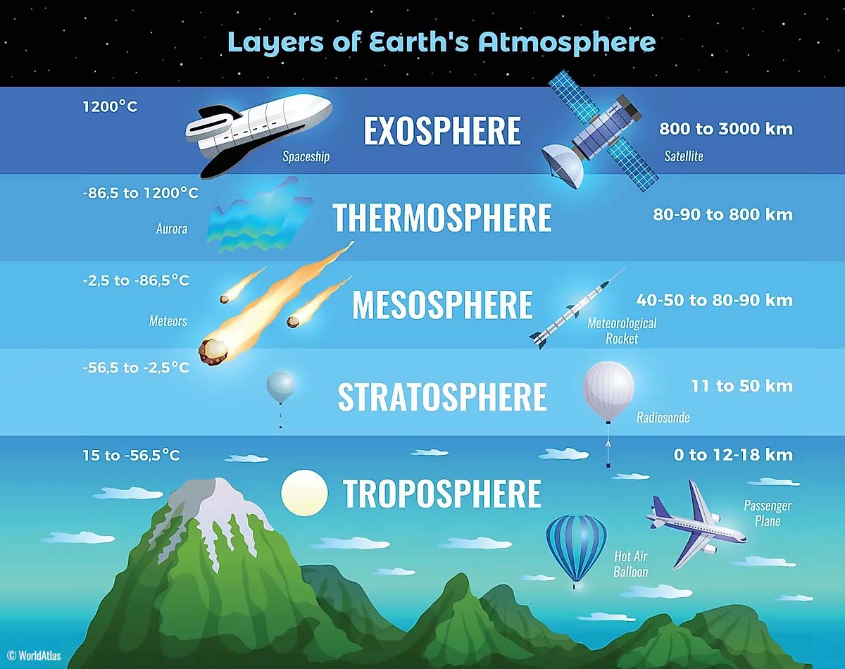
The lowest one sitting on the Earth’s surface layer is the troposphere, this is where all the weather changes we encounter take place. The troposphere layer is extending from the surface up to around 12 km in the sky. The depth of this layer varies between 8 km to almost 20 km, depending on where you live. The troposphere is the deepest above the equatorial region, and it gets much thicker above the North and South poles.
Right above it, there is a much deeper layer, known as the stratosphere. The stratosphere layer is near 10-50 km deep and the air in it is also very dry. This layer also contains the Ozone layer, the one that has a vital role in the protection of our planet’s life against the storms from the Sun.

In the stratosphere, the most important part that actually triggers all the weather dynamics is known as the Polar Vortex. The Polar Vortex is an enormous, three-dimensional ring of violent winds high above our heads. It surrounds both the North and South poles, grazing the air at about 20-50 km above the Earth’s surface.
The Polar Vortex is the strongest during the winter months in both the Northern and the Southern hemispheres. It is unusually strong this Winter Season 2021/22. So in general, the Polar Vortex is affecting the winter weather from October through March every year.

To conclude, both the troposphere and the stratosphere layers are particularly crucial for the climate we live in, as the Polar Vortex actually covers most of the bottom half of the atmosphere. It extends from the middle of Earth’s troposphere up into the stratosphere layer. Therefore, the Polar Vortex has the main role in the winter weather across the high and mid-latitudes as we could see across North America, Europe, and Asia, and indeed the Pacific and Atlantic oceans.

Although the Polar Vortex spins far above our heads, it remains directly connected to the lower part of the atmosphere. Thus, it gives our daily weather a shape in many ways, as it works as one large hemispheric circulation. All the dynamic systems we have seen this winter have been triggered with the activity of the Polar Vortex above.
How the Polar Vortex forms?
From the early autumn months, the northern hemisphere polar regions start to receive less and less sunlight over time. This is the consequence of the stronger inclination of the Earth’s axis, as the North Pole is sent into the position that it starts cooling down. As a result, polar nights occur for several months, with days without any sunlight following.

In the time the polar regions are getting colder and colder, the atmosphere layers towards the equatorial regions to the south are still relatively warm compared to the areas farther north. Those regions, therefore, continue to receive much more sunlight and energy from the Sun, thus creating a high-temperature contrast between them.
So as the poles are getting cooler, this is also translating into lowering the surface pressure there. Actually, this is a pretty similar weather process that also happens in the stratosphere layer above it, the temperature difference between the North pole and the equatorial areas increases. The result is the development of a large low-pressure cyclonic circulation across the polar stratosphere. Hence, this is why we call it the Polar Vortex.

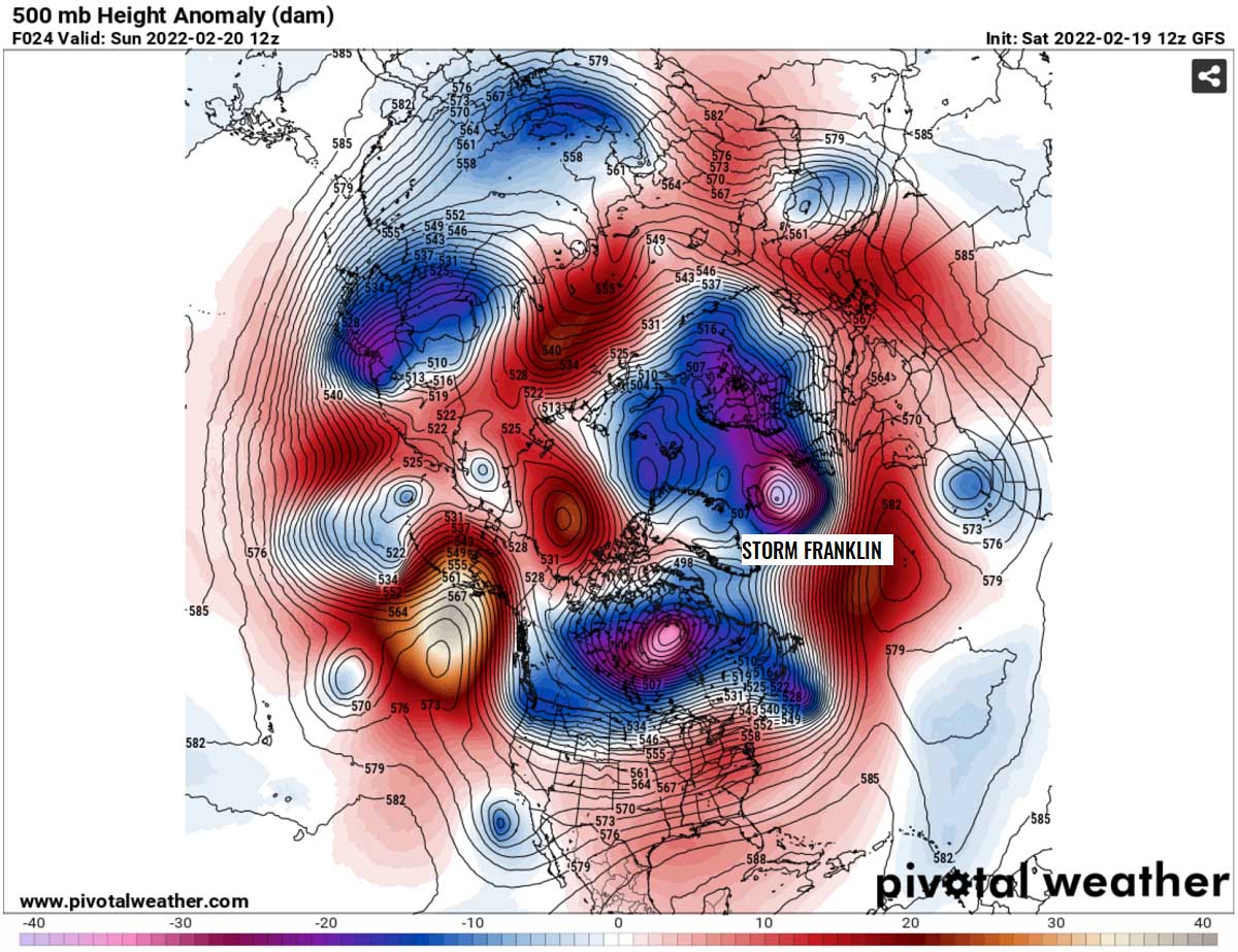
Putting all these facts together, the Polar Vortex is acting as a very large and thick cyclone. It covers the whole North Pole, extending down to the regions in the mid-latitudes. It is of course the same also in the southern hemisphere. If you look above, the chart hints at a very typical example of the Polar Vortex set above us, at around 30 km (18 miles) altitude which is near the top of the stratosphere layer during the winter season.
The unusually intense and active Polar Vortex this year has been the main trigger behind the recent storms Dudley and Eunice, and will also be the driving factor for storm Franklin and the new storm next week. As it typically happens, the leading upper wave disturbance emerges from Arctic Canada drags the cold air into the North Atlantic and its response is rapid cyclogenesis towards Europe.
This usually leads to a combination of fresh Arctic cold air with the intensifying winter storm ejecting eastern North America, setting a stage for a significant deepening farther northeast in the Atlantic. The central pressure will be deepening very rapidly, and we often then see a so-called bomb cyclone, a meteorological term that we use when the central pressure of the system falls extremely rapidly. Note that the lower the pressure is, the stronger the storm becomes.
WHAT IS A BOMB CYCLONE AND HOW DOES IT FORM?
The pressure change that we are in the forecast charts from Monday through Tuesday in the North Atlantic and around Iceland are the typical criteria that mean the system will be easily classified as a bomb cyclone. In other words, the surface cyclone will be rapidly intensifying, with its central pressure falling very fast (or even extremely fast for some time).
This is the time when you will hear wording explosive cyclogenesis (also known as bombogenesis) as we face the rapid deepening of the barometric pressure of a developing low.
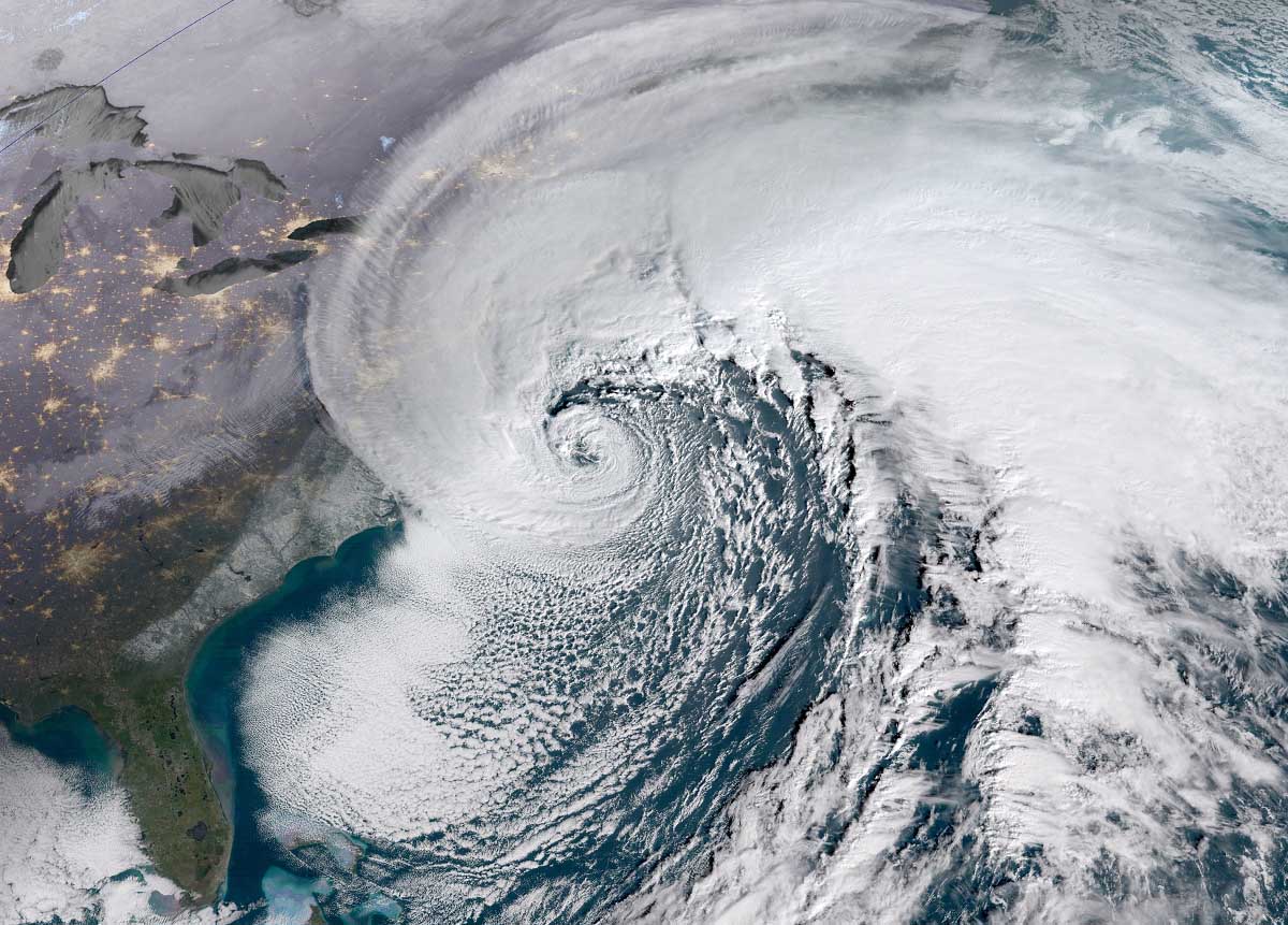
Generally speaking, a pressure fall of at least 24 millibars within 24 hours is the must-needed criteria to meet that the system can be classified as a bomb cyclone. It is a purely non-tropical system, also known as an extratropical cyclone that develops rapidly from a low-pressure system. A typical example of such a bomb cyclone is seen on the satellite picture above. This is a classic Nor’Easter bomb storm along the U.S. East Coast from a few years ago.
The extratropical storm in the North Atlantic can grow very large in size, usually dominating a large portion of the ocean (or the North Pacific on other occasions). Due to the Coriolis force, the general movement of these systems in the Northern Hemisphere is towards the northeast. The very large size of them produces severe to extremely severe, hurricane-force winds. Also generating massive waves, coastal floods, and indeed severe winter storms with a blizzard over the land.
Very similar to a classic extratropical low, a bomb cyclone is fueled by variations in the temperature. Interaction of the warmer air mass from the Equator and much colder temperatures from the Arctic region occurs. And all these processes are also happening vertically throughout the atmosphere.
Note, that these types of Atlantic storms are, despite reminding us of tropical cyclones by the satellite imagery, very different from those systems occurring during the hurricane season. Hurricanes are getting their energy source from extremely warm sea surface temperatures found only in the tropical region.
Meteorologists are tracking these systems with annual statistics, as the east coasts of the North American continent are known as the perfect breeding grounds for these types of cyclones during the late fall and winter months. They often bring damaging winter storms to portions of Canada and Northeast United States and often continue into the North Atlantic and Europe as violent storms.
This occurs because the interaction of Arctic cold continental air mass from Canada with the warm, moist oceanic tropical air near the Gulf Stream in the Atlantic provides tons of energy for a cyclone to explosively develop over the warmer waters.
We will often see bomb cyclones during winter months in the North Atlantic, the same with the Nor’Easter storms. Although these cyclones can actually occur all year round. On average there are 60-70 bombs formations on Earth annually and about 50 of those are found in the Northern Hemisphere. Off the east coasts of the U.S. and the Atlantic.
Let’s now focus on the upcoming severe threats, we will take a deeper look the Sunday’s storm and then the bombogenesis following behind on Monday.
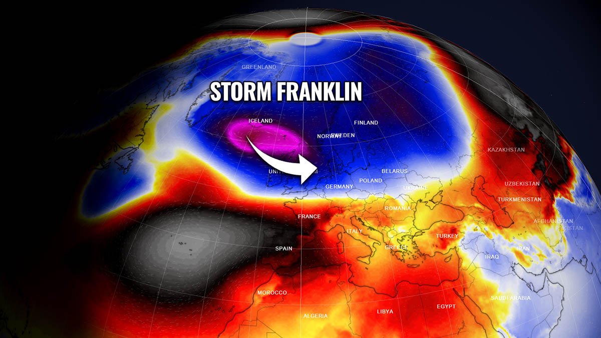
POLAR VORTEX DRAGS STORM FRANKLIN STRAIGHT TO WESTERN EUROPE SUNDAY NIGHT
While the deadly Eunice is finally leaving the European land, the North Atlantic is chewing the air masses together, soon producing more threat for the western Europe residents. Again, thanks to the southern lobe of the Polar Vortex sitting over eastern Canada, a plume of Arctic air is maintaining cold intrusion deeper towards the south. It feels like this Arctic plume is nowhere near its end, as it keeps fueling the region with deep troughs from the north.

As it typically happens, this triggers more storms and helps to rapidly deepen them while they move towards Iceland and western Europe. The first system in a line is the new, potentially damaging windstorm Franklin.
There is a pretty huge contrast of much warmer subtropical air against the Arctic cold present again. While the warm air overspreads southwestern and western Europe, it is followed by a much colder air in the wake of a large wave. This is how, between the strong Azoric high on the south and deep Icelandic low, the strong westerly jet stream (zonal flow) will help Franklin turn towards a more east-southeast trajectory.
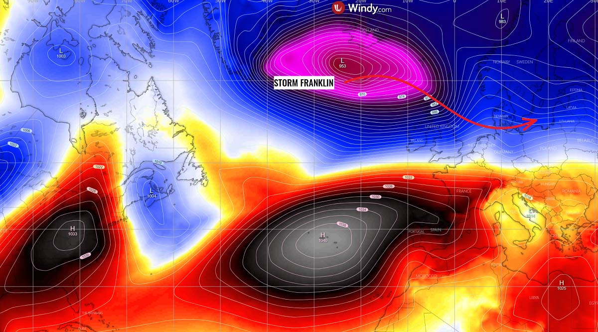
Storm Franklin should deepen considerably through Sunday, possibly to near 955 mbar in the morning hours, before reaching its mature extratropical low phase. This is the main concept of the system this time, it matures into a very large cyclone and generates a much wider size, and should develop a more widespread impact with both violent winds and major waves.
Franklin will continue moving southeast through Sunday night with the pressure gradient becoming very tight across Ireland, Northern Ireland, and the UK. This means nothing else than violent winds to develop. Attached below is the sequence of storm Franklin traveling from the south of Iceland across Scotland Sunday night, reaching Denmark on Monday morning with gradually rising central pressure but remaining very intense.
The weather models are hinting at some pretty rough weather across a large portion of western Europe again, with heavy rain and severe wind squalls to the south of the center low and behind the main cold front. Graupel showers are also possible to be mixing with cooler maritime air mass from the Atlantic.
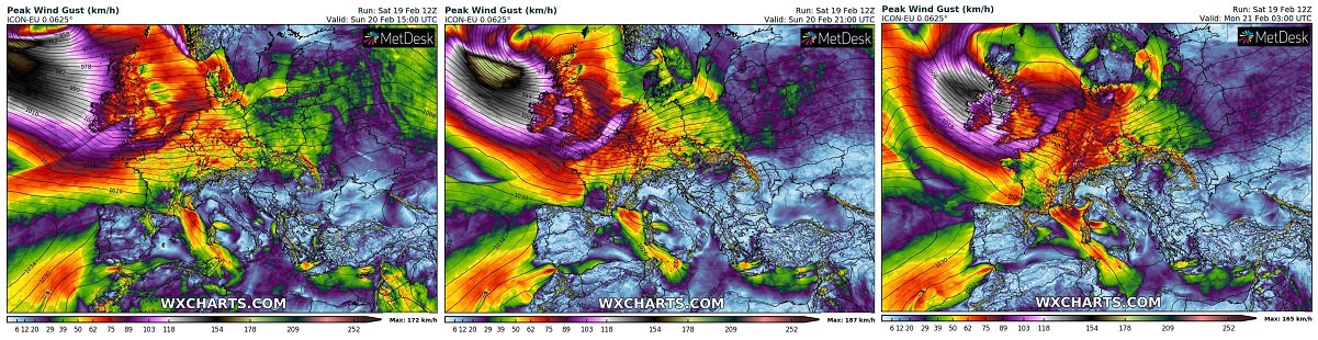
VIOLENT, HURRICANE-FORCE WINDS EXPECTED FOR IRELAND, NORTHERN IRELAND AND SCOTLAND
When we have such a deep low, keep in mind the central pressure will remain in mid 960 mbar while it will travel across Scotland, so it should no doubt lead to some pretty violent winds in the most westerly exposed areas. That is especially across northwestern North Ireland and western Scotland where the strongest pressure gradient will be in place.
The highest wind gusts could reach well above 80 mph, possibly even close to 100-125 mph (160-200 km/h) locally again, just off the coast to the west-northwest.
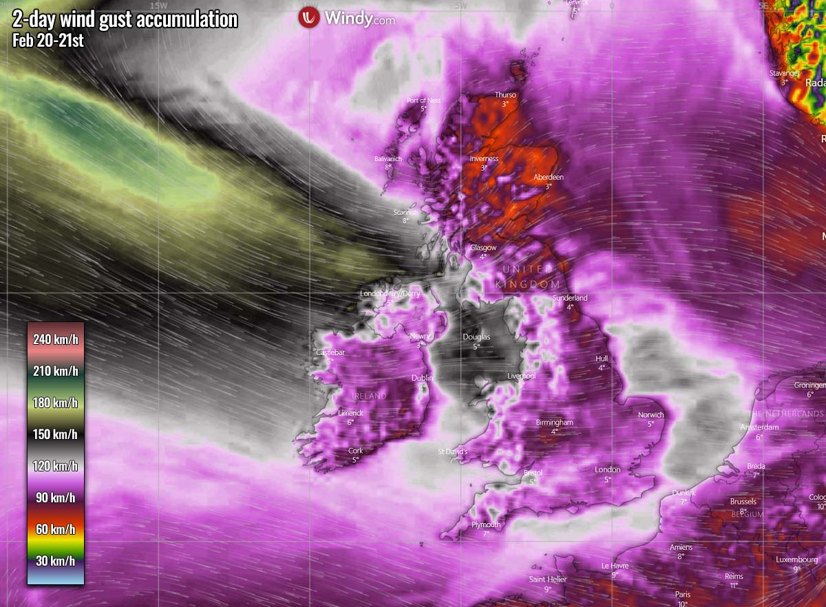
So large and intense wind fields will also generate huge sea waves, which will likely exceed 16 meters near the center of the wind maximum. And gradually spread southeast while the system will be advancing towards Scotland and the North Sea Sunday night.
Waves will be of major heights with large swell across the whole western coast of Scotland, Northern Ireland, and western Ireland. Those could be up to 12-14 meters as well, causing damage to the coastal areas and erosion.

Although the winds will be so intense and persistent, the amounts of rain will not be too particularly high, rainfall peaks are expected mainly within the terrain-induced orographic precipitation areas. Those include Wales, western and northern England, and indeed western-central Scotland. These areas should receive about 30-70 mm of rain through Monday morning.
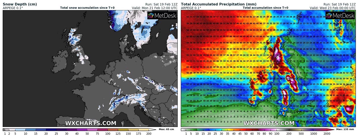
With temperatures relatively warmer this time, some snow is forecast only for the highest elevations, e.g. Scottish Highlands and northern England, possibly even in the highest parts of Wales. Attached above are the side-by-side rainfall and snowfall forecast.
Once Franklin moves across the North Sea and Denmark on Monday, it re-intensifies on its way across southern Sweden to the Baltic region. It will be a quite strong frontal system will a decent amount of snow and near-blizzard conditions for southern Sweden and Finland, as well as for the Baltic countries Monday through the night.
The strongest winds should be in excess of 120 km/h, mainly along the Baltic coast of northern Poland.

Dangerous wind threat will gradually decay across western Europe on Monday, while the North Atlantic will already be generating a new violent cyclonic system. It will be a classic bomb cyclone we discussed earlier.
ANOTHER MONSTER STORM – A BOMB CYCLONE HEADS FOR ICELAND AND FAROE ISLANDS ON MONDAY NIGHT
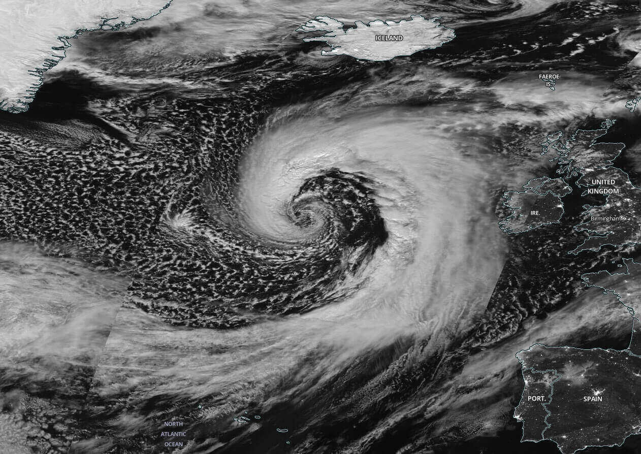
Actually, pretty similar to what we have seen at the end of January in the Atlantic, a textbook development of a bomb cyclone is triggered with the continuation of the Arctic plume of cold air under the lobe of the Polar Vortex aloft. The P.V. has been so particularly strong this Winter Season 2021/22, it just doesn’t stop dragging outbreaks of very cold, often frigid cold Arctic air mass across the North American continent into the Atlantic Ocean.
An ideal recipe for the Polar Vortex to trigger explosive extratropical storms development again. The geocolor spectrum satellite image from this Saturday is revealing a very impressive look of a perfect example of the developing storm, induced by the transport of Arctic air.

Notice the huge frontal zone extending from the southern tip of Greenland basically way south into the tropical region to the Gulf and Mexico. Separating two huge airmass reservoirs, the Arctic cold versus the warmer and moist sub-tropical air that clash together on Sunday. That is why it will be leading to literally an explosive development of a bomb cyclone.
With a completely typical process of this kind of weather setup, the low will be undergoing a significant bombogenesis phase for about 24 to 36 hours, starting Sunday morning with the new wave emerging off Newfoundland. It is forecast to mature into a violent extratropical storm by Monday morning. We can expect that its structure will be pretty spectacular at the peak intensity.
Satellite images typically reveal an appearance of the cloud bands symmetrically wrapped into a tightening core of the cyclone. The example below is such a system back from October 2020 when a Hurricane Epsilon was also in sight near Bermuda.

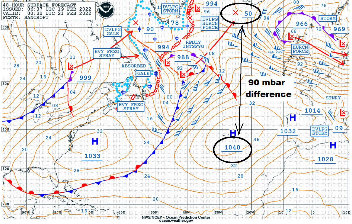
The NOAA Ocean Prediction Center (OPC) forecast map for Sunday reveals that this new system will have a central pressure of 988 mbar, centered to the east of Newfoundland, Canada. The baroclinic frontal zone drags east and south, thanks to a strengthening High along the U.S. East Coast.
The NOAA’s chart reveals the rapid intensification process is forecast within the following 24 hours, from Sunday morning through Monday morning. The low should deepen from upper 980s to near 950 mbar according to the OPC forecast. Developing hurricane-force winds while approaching Iceland. Notice also how huge the pressure difference is over the Atlantic at the same time, 1040 mbar High over the Azores against the Icelandic low of 950 mbar.
It will cause heavy freezing spray with violent winds in the system’s wake, blasting the Newfoundland and the southern Labrador Sea up to southern Greenland all day on Sunday. Definitely rough times for the marine traffic crossing this region from Sunday into Monday, battling some incredibly dangerous conditions of violent winds, freezing spray, and huge 10-12 meter sea waves.
The system will actually start on Sunday around 06 UTC off the New England, the US, having the central pressure of around 1002 mbar, before entering the bombogenesis process traveling south of Newfoundland into the North Atlantic. Deepen to around 974 mbar during the first 24-hour period (Monday 06 UTC), followed by an additional remarkable drop to 952 mbar by Monday evening (18 UTC).

That is a 28 mbar drop over the first 24 hours, followed by another 22 mbar pressure drop through the 12 hours afterward. Remember the criteria for a bombogenesis pressure change of 24 mbar in a 24-hour period? This system will smash through these criteria pretty easily, of course, a normal occurrence for bombogenesis storms. That’s a really explosive development at its finest!
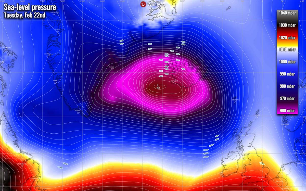
From Monday night into Tuesday, the central pressure will continue deepening further but the rapid intensification period will end before the night. Pressure should bottom out at around 945 sometime on Tuesday when the system wobbles between Iceland and Greenland. It will result in wild winter weather across both Iceland, southeast Greenland, and the Faroe Islands on Monday night through Wednesday morning.
Violent, hurricane-force winds are expected within the rapid intensification process while the cyclone will be on its way towards Iceland on Monday, very likely reaching peak wind gusts in excess of 160-180 km/h, potentially even higher. Those will most likely be a result of a sting jet we have discussed earlier, as a typical occurrence with the bomb cyclones forming this week.
Another area where winds will be particularly intense is again Iceland and also the Faroe Islands at the time the storm on its approach these countries on Monday night into early Tuesday. Especially Iceland will be in a favorable spot to destructive winds, locally in excess of 200 km/h across the complex terrain of the country.

As it’s well seen on the chart above, another wind maximum is forecast to be in the Denmark Strait between Iceland and Greenland, once the low retreats back north-northwest after occluding on Tuesday morning. Due to the very strong pressure gradient between the Icelandic low and Greenland High, winds will significantly increase. Peak gusts as often exceed 200 km/h across the strait when this occurs.
With so broad winds spread across the Atlantic, significant wave heights are forecast. As typical with these systems, the largest waves will be to the immediate south of the center low and will likely be reaching 12-15 meters. Waves will gradually move northeast between Iceland and Scotland on Tuesday, being the worst between Faroes and Iceland.

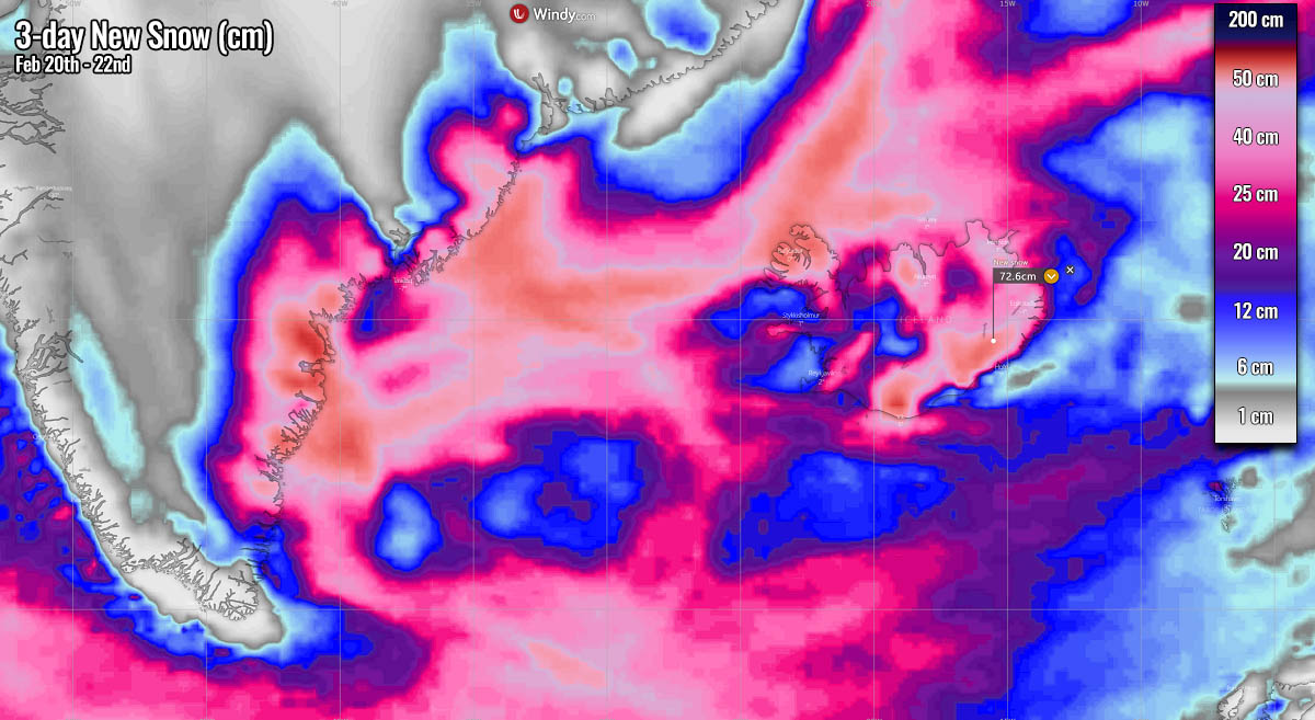
Intense snow will develop across Iceland and southeast Greenland Monday night, with pretty high snowfall rates, quickly accumulating. About 30-50 cm seems reasonably possible across a large part of Iceland, even close to 1 meter of fresh snow higher in the internal mountain ranges. Similar across southeast Greenland. About 15-30 cm also across parts of Faroe Islands.
Blizzard conditions are expected to develop as well, as the combination of heavy snow and violent winds will be ideal for extreme driving conditions, snowdrifts, and road closures. It will be pretty unsafe to drive across most of Iceland on Monday night and Tuesday. Whiteout conditions with visibility reduced to near zero are pretty much expected in many areas.
Conditions will be finally improving late Tuesday with winds weakening, but the Arctic cold will overspread the North Atlantic. The cold maritime airmass will be resulting in widespread showery weather, with numerous snow and graupel showers.
Towards Wednesday, this cold air will also reach Ireland, Northern Ireland, and the UK, which should bring snow showers and some accumulations as well through Thursday. At the same time, with the continuation of Arctic cold flow into the Atlantic after mid-week, more intense extratropical storms are likely.
Weather models hint a new one for Iceland around Thursday or Friday and possibly another deep monster over the weekend.
CLASSIC WARM SECLUSION APPERANCE IN THIS CYCLONE
Ahead of the very active weather pattern across the North Atlantic, a much warmer air mass will spread into western and southwestern Europe, a typical zonal warmth for the continent. While in the wake of the Atlantic low, the northwesterly winds will drag the Arctic cold air mass into the Northwest Atlantic.
This develops a pretty didactic fluid dynamics presentation on the chart, we can see how the large-scale processes are working together while the lobes of the Polar Vortex above trigger weather systems.

The pretty impressive temperature contrast image above is a textbook example when it comes to the violent extratropical lows in the North Atlantic. Extremely cold Arctic air is spread across eastern Canada, with frigid low temperatures, nosing southeast into the northwestern Atlantic.
Farther east, the violent force of the exploding extratropical low will do the contrary. A very strong warm advection of subtropical air mass will be advected very far north again, rounding the center low with a classic comma shape of the temperature map. This process is known as warm seclusion, defining the mature phase of the extratropical cyclone lifecycle is near.

Warm seclusion could have cloud-free, eye-like features on the satellite imagery at their center. Sometimes it can be reminiscent of tropical cyclones. It indicates that the system’s warm-core center is surrounded by hurricane-force winds, along the bent-back warm front. After the warm seclusion is completed, the mature stage of a cyclone is in full mode, and a system starts its decaying process and system intensification is completed.
These kinds of systems and weather patterns are actually quite classic during winter months for the North Atlantic, following after stong Arctic outbreaks from Canadian Arctic and Greenland, penetrating onto the much warmer sea waters. Warm-seclusion storms normally produce violent winds and waves. Often, winds are particularly violent with hurricane-force speeds in a very narrow area to the south-southwest of the cyclone’s core.
The main driving factor to force these destructive winds is known as the sting jet wind maximum, forming inside the cloud head into the frontal‐fracture region of a Shapiro-Keyser cyclone.
WHAT IS A STING JET
From what you have heard with the Storm Eunice, the meteorological phenomenon that is usually blamed to produce violent (hurricane-force), and destructive winds are known as a sting jet. This particularly intense swath of winds is often leading to peak wind gusts well above 150 km/h, sometimes those even surpass the 200 km/h. A Sting jet is a narrow zone of extremely severe winds, originating from inside the mid-tropospheric cloud head within the explosive cyclogenesis or a bomb cyclone.
By default, a textbook extratropical cyclone is made of two frontal zones, the warm front, and the cold front following it. A strong wind flow of cold air mass develops into the cyclone ahead of the warm front, which is known as the cold conveyor belt. Following behind the main cold front, a much cooler and also drier air mass, very often originating from the Arctic region, flows into the cyclone’s core. Thus, forming the dry intrusion towards the center of a deepening cyclone, typically rounding the low, emerging from the southwest direction.
Generally, the cold conveyor belt brings cold and moist air towards the center of the extratropical storm, together with precipitation such as rain and snow. Meanwhile, the dry intrusion brings cooler and also very dry air into the cyclone. With the precipitation falling from the cold conveyor belt into the dry air within the dry intrusion, those droplets are quickly evaporating and lead further to cool the air mass with a process known as evaporative cooling.

Finally, as the jet of strong winds descends towards the surface, those are intensifying more as the air is drying out. The winds are literally grazing and evaporating the layers of air on the nose of this descending jet. Thus, creating a clear path through the precipitation. As the evaporative cooling also leads to the air becoming much denser within the jet, this causes the acceleration of the downward momentum. In other words, winds are pushed down towards the tip of the cloud head when it wraps around the cyclone dead center.
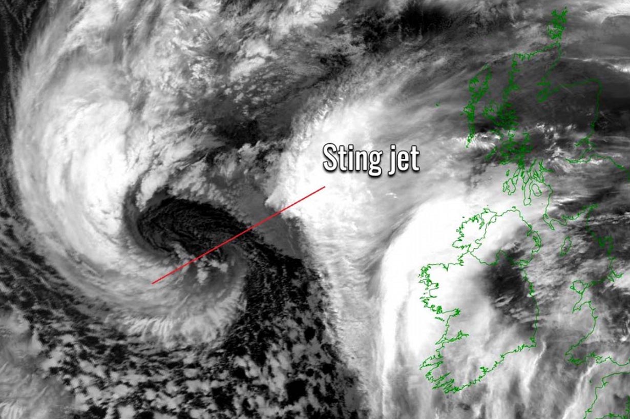
These processes with the sting jet are occurring at altitudes at about 3-4 km above sea level and lead to extremely severe wind gusts. Those are very often easily exceeding 90-100 mph (150-160 km/h) or evening stronger than 125 mph (200 km/h) with the most intense cyclones. A developed sting jet wind maximum is fairly easily recognizable as the cloud, hooked just like a scorpion’s tail. This gives the violent wind region its famous name.

The composite satellite image above hints at how well the shape of a textbook cyclone with a sting jet looks like with a scorpion’s tail layered above. Pretty fascinating, huh. A sting jet usually affects a small region of about 100-200 km across only and is compared to the size of the parent large bomb cyclone rather narrow. It usually lasts only for several hours, but it if reaches the land areas, destructive winds occur.
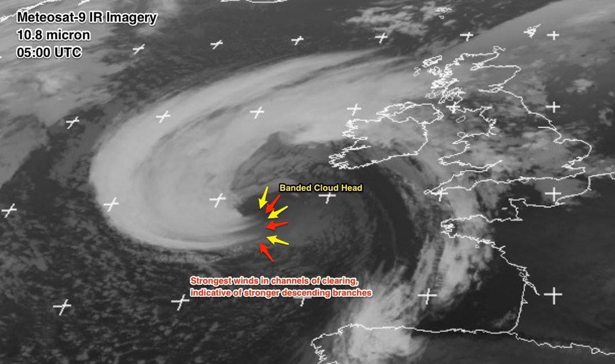
When we see storms developing so explosively over the Atlantic Ocean, we can expect a rather typical satellite appearance of the banded cloud heads associated with any type of these bomb cyclones having sting jets. As we saw above, the cloud head is strongly curved into the cyclone, that is why it will look like a scorpion’s tail and stinger alike shape.
Also note, that these cloud bands disappear quite sharply on the jet’s front edge due to the effect of evaporation in the dry air of the dry intrusion.
Images used in this article were provided by Windy, TropicalTidbits, and Wxcharts.