The Polar Vortex is starting to power up unusually in the late Winter Season, reaching record cold levels in the lower stratosphere. This is not without consequences, as it will strengthen the polar circulation into late winter and will be ready to continue into early Spring, influencing the weather in the United States and Europe.
The Polar Vortex is a powerful short-to-medium term weather component during the cold season. It is strongly connected all the way from the ground up into the higher levels of the atmosphere.
For this reason, we always take great notice of the activity high above in the stratosphere and monitor it all the time. In the next days, the Polar Vortex will behave a bit unusual, as it will kick into overdrive, reaching near record-high power values for this time of year.
First, we will quickly and simply learn what the Polar Vortex really is and how is it so influential. We try to explain this in most of our winter articles, as this is an important part of every winter season.
Such powerful yet simple knowledge really helps to understand the bigger picture of how the weather works in the large picture.
NORTH HEMISPHERE POLAR VORTEX
The Polar Vortex can be simply explained as a very large cyclonic circulation, covering the whole north pole, down to the mid-latitudes. It has a strong presence at all levels, from the ground up into the middle atmosphere, having different shapes at different altitudes.
The Polar Vortex is so large that we have to divide it into two altitude parts. One is the lower (tropospheric) part and the second is the upper (stratospheric) part. The stratospheric polar vortex plays an important role in weather development, while the lower tropospheric polar vortex actually circulates the weather that we experience.
But what is this stratosphere? Well, the atmosphere has different layers. Our weather is found in the lowest layer of the atmosphere called the troposphere. It reaches up to around 8 km (5 miles) altitude over the polar regions and up to around 15 km (9-10 miles) over the equator.
Above it, we have a much deeper layer called the stratosphere. This layer is around 30 km/18.5mi deep and is very dry. The Ozone layer resides in the stratosphere. You can see the layers of the atmosphere on the image below, with the troposphere and the weather on the bottom and the stratosphere with the ozone layer above it.

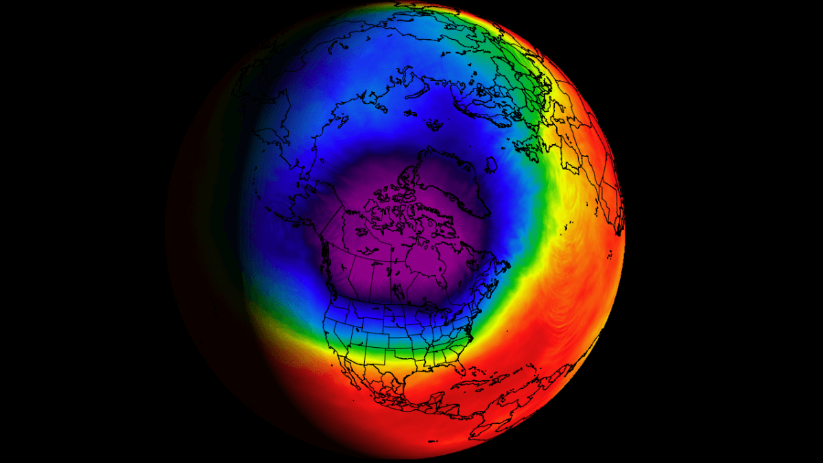
The image below shows a typical example of the upper Polar Vortex at around 30km/18.5miles altitude in the middle stratosphere during winter. It has a very nice circular shape, with the temperature dropping quickly towards its inner core.
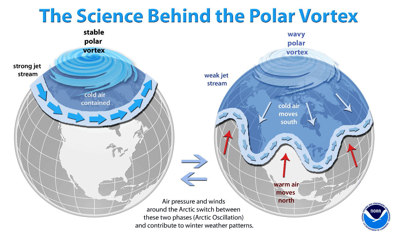
A strong Polar Vortex usually means strong polar circulation. This usually locks the cold air into the Polar regions, creating a milder winter for most of the United States and Europe.
As a contrast, a weak (wavy) Polar Vortex can bring very dynamic weather. It has a much harder time containing the cold air, which can now escape out of the polar regions, into the United States and/or Europe. Image by NOAA.
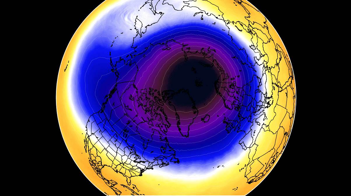
In the next image below, we have the polar vortex at a much lower altitude, around 5km/3miles. The closer to the ground we go, the more deformed the polar vortex gets because it has to interact with the mountains and overall terrain and also with the strong weather systems.
Be aware of the cold “arms” extending out of the polar vortex. They bring colder air and snowfall into the mid-latitudes. These arms pack a lot of energy and can create strong winter storms, like for example Nor’easters in the United States or very strong wind storms across the North Atlantic.
For an even better idea, we produced a high-resolution video for you, which nicely shows the Polar Vortex spinning over the Northern Hemisphere at the 30mb level, around 23km/14miles altitude.
Video shows the NASA GEOS-5 analysis for late January. Notice how the polar vortex covers a large part of the Northern Hemisphere. You can nicely see how it spins over the Northern Hemisphere, driving also the winter weather with its circulation.
But why (and how) does the polar vortex even form every winter season?
Every year as we head into autumn, the polar regions start to receive much less sunlight. This way, cooling begins over the north pole. But as the polar temperatures drop, the atmosphere further south is still relatively warm as it continues to receive energy from the Sun.
You can see the winter solstice on the image below when the polar regions receive little to zero solar energy, compared to regions further south.

So, as the temperature difference towards the south increases, this also means pressure changes. A large low-pressure (cyclonic) circulation starts to develop across the Northern Hemisphere from the surface layers, far up into the stratosphere. This is known as the Polar Vortex.
While the stratospheric polar vortex is spinning high above our weather, it is still directly connected to the lower levels and can shape our daily weather in many ways, driving it as one large circulation over the entire hemisphere.
POLAR VORTEX POWERING UP
When looking at the polar vortex in the stratosphere, we tend to use the 10mb level. That is around 28-32km (17-20 miles) in altitude. This layer is considered to be in the mid-stratosphere and provides a very good representation of the general strength of the stratospheric polar vortex and its downward connection.
The strength of the polar vortex is most often measured by the power of the winds that it produces. This is typically done by measuring the zonal (west to east) wind speeds around the polar circle (60°N latitude).
On the image below we have the seasonal average zonal wind speed for the Polar Vortex at 10mb level. The black line is the long-term average. Winer season last year is the red line, and the blue line is the current winter season 2021/22. The yellow area shows the daily historical min/max wind speeds. Image from weatheriscool.com
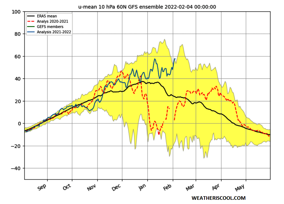
It is obvious that this season, the polar vortex is having a near-constant power increase. It was fluctuating up/down but kept a steady uptrend in power. Looking at the black “average” line, the polar vortex typically starts the seasonal weakening in mid-January.
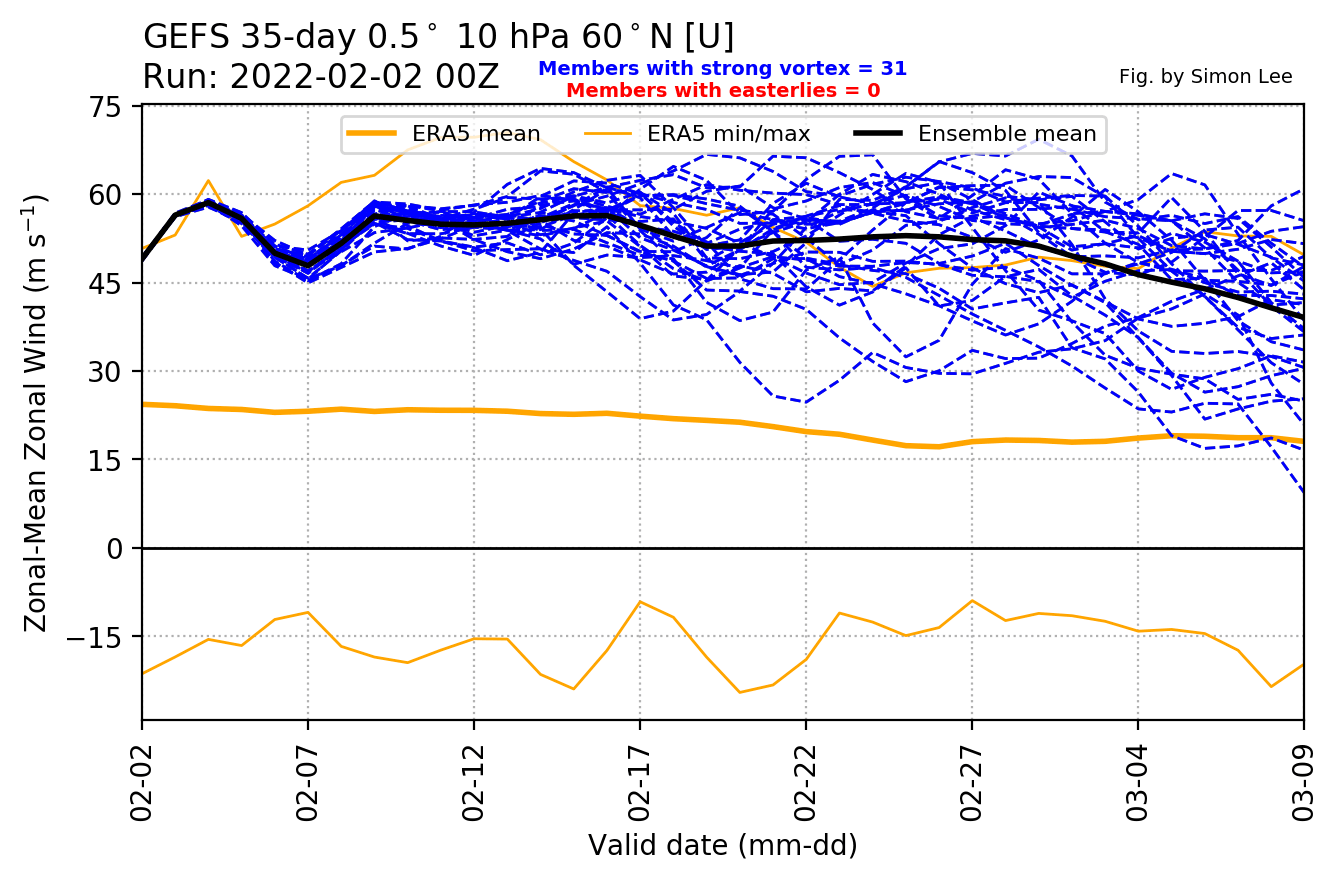
Below we have an extended ensemble forecast for the 10mb winds. It shows the polar vortex currently being quite stronger than average. The forecast keeps it at a very strong level, reaching unusually high power for this time of year.
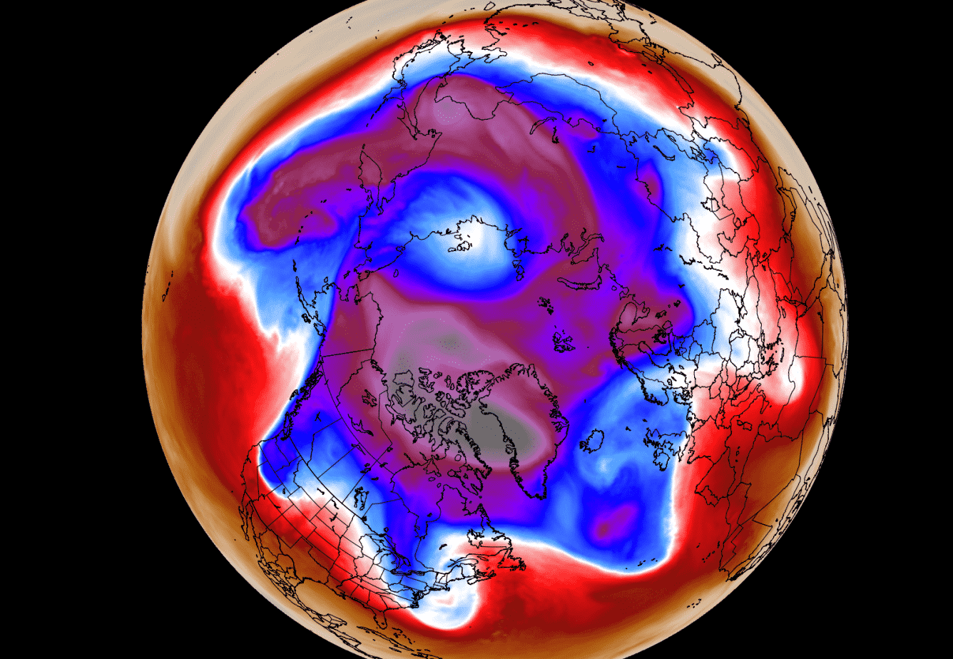
Looking at the pressure anomalies over the polar regions in the past three months, we can notice an interesting progression. The next image below shows pressure anomalies from the surface into the upper stratosphere.
You can observe the strong low-pressure buildup in the stratosphere in late November. That was a strong polar vortex, connecting easily down to the surface levels in early December. But strong high-pressure anomalies have emerged over the polar circle in December, which pushed back against the stratosphere, “disconnecting” the upper and the lower polar vortex.

In late January, we can see the strong buildup of low-pressure anomalies in the stratosphere. That corresponds to the high power and circulation of the stratospheric polar vortex. It is currently not fully connected down on a hemispheric level but has a more local connection.
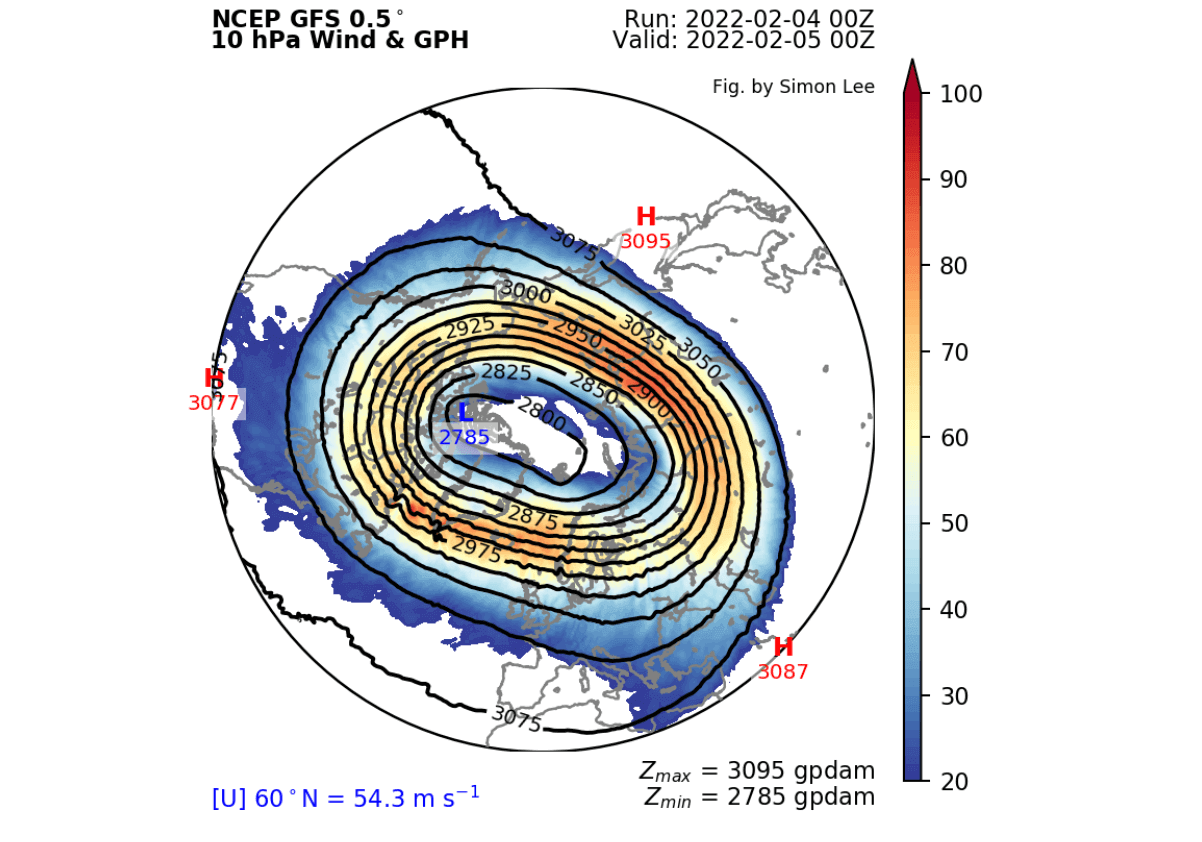
Looking at the current polar vortex development, we can see that the vortex is in a good shape. It has a slightly oval shape, but a strong and stable wind field. There is a semi-persistent high-pressure area in the North Pacific and East Asia pressing against it, creating its oval shape.
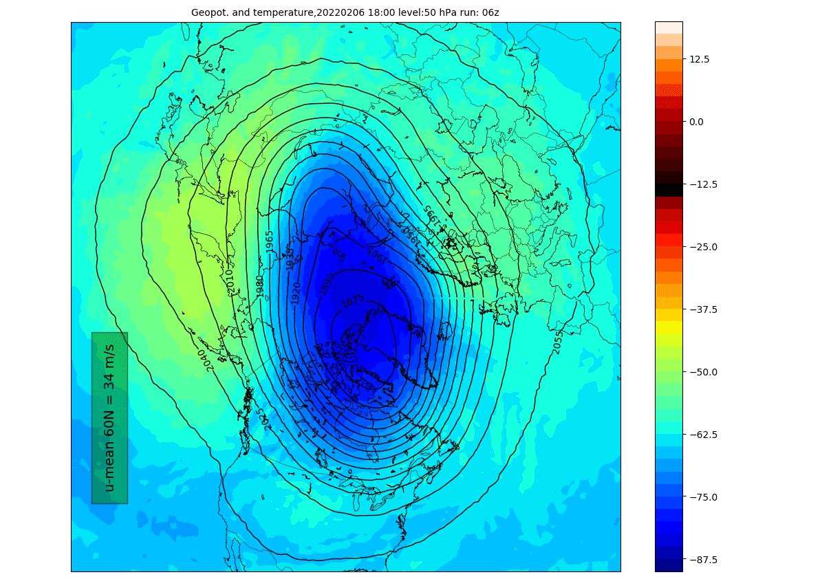
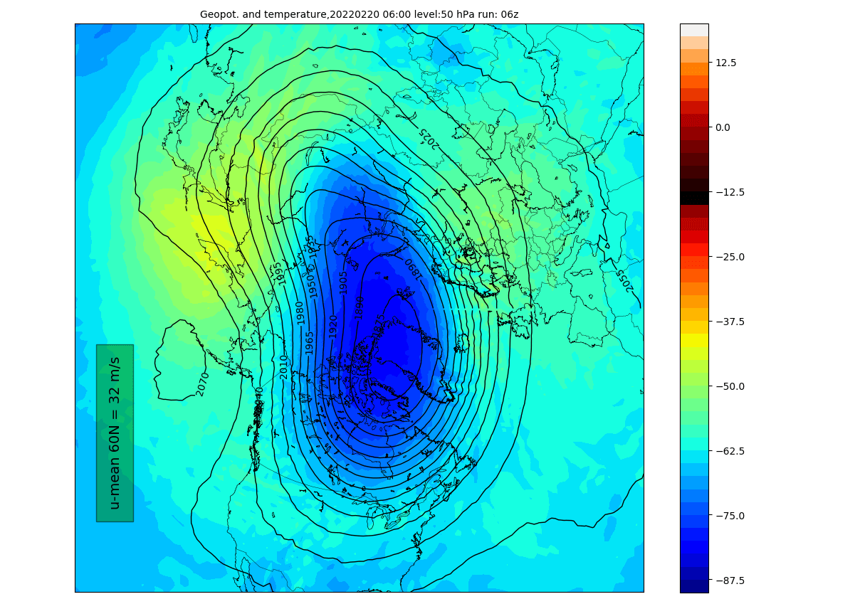
Taking a look at the temperature profile at the 50mb level (19km/12mi), we see its cold-core over the Arctic regions and Greenland. This altitude is considered to be the lower stratosphere and is more connected to the weather circulation in the lower levels.
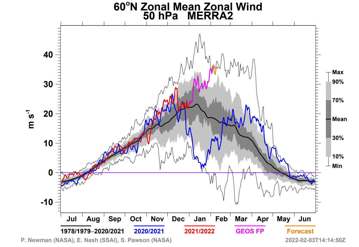
Below we have a zonal mean (average) temperature for this 50mb level over the polar circle, from NASA. You can see a steady cooling, continuing with a strong pace in the past weeks. The forecast (orange line) shows that the temperatures at this level will reach record cold values in the next few days.

The latest temperature analysis below shows the temperature anomalies over the northern hemisphere at the 50mb level in the lower stratosphere. We can see that the polar vortex here is actually around 20 degrees C colder than normal. These are quite substantial anomalies.

The upper and lower polar vortex is still just one large area of circulation. So when the stratospheric polar vortex gets faster and colder, that can usually mean that its power and influence are increasing. That also increases the chance of taking over the weather patterns.
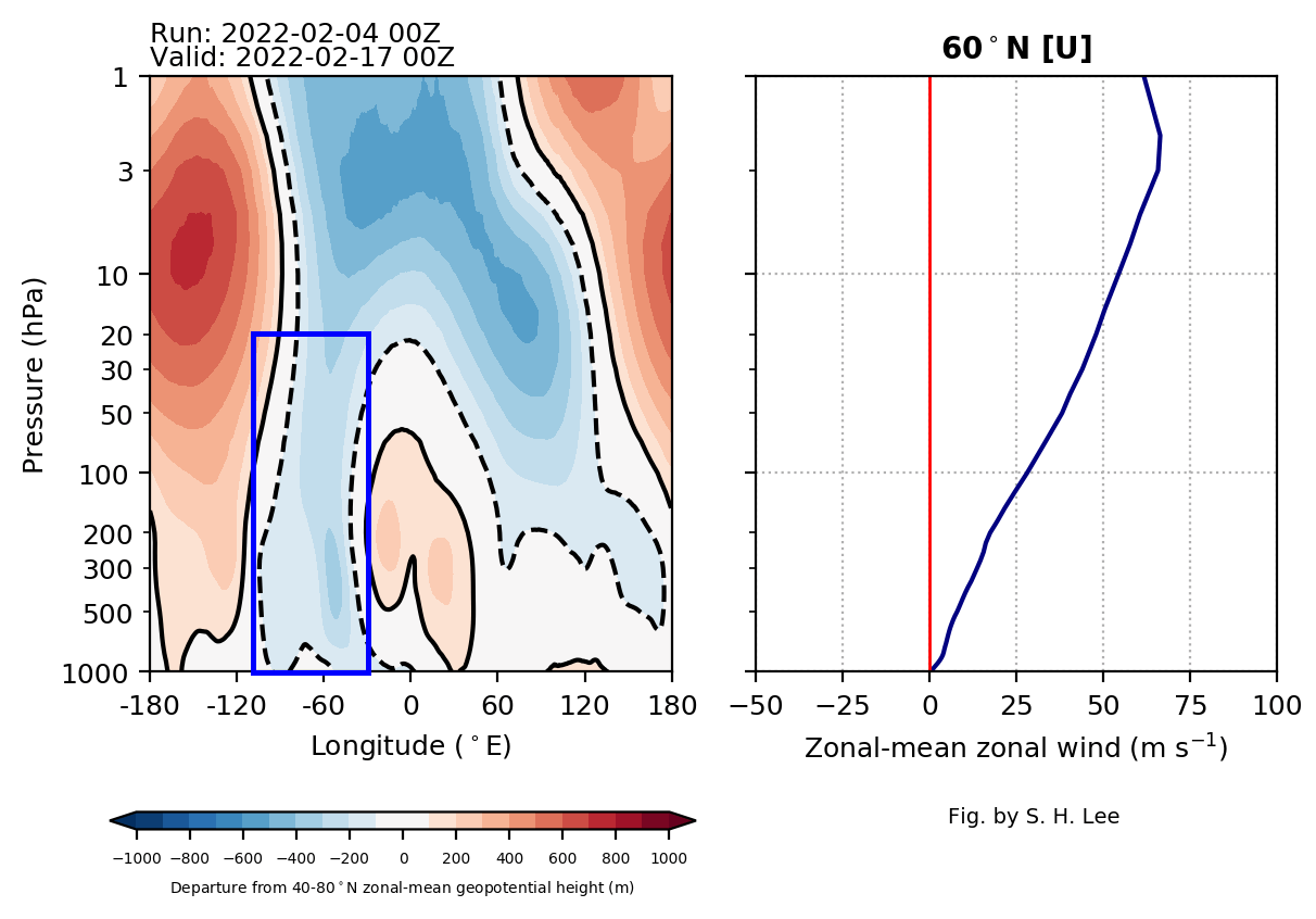
The vertical pressure anomaly profile reveals a connection already in place. We can observe the stratospheric low-pressure anomalies extending down from the stratosphere to the lower levels. A direct connection in the -60 to -90 Longitude is observed, exactly where the low-pressure system over eastern Canada can be found.
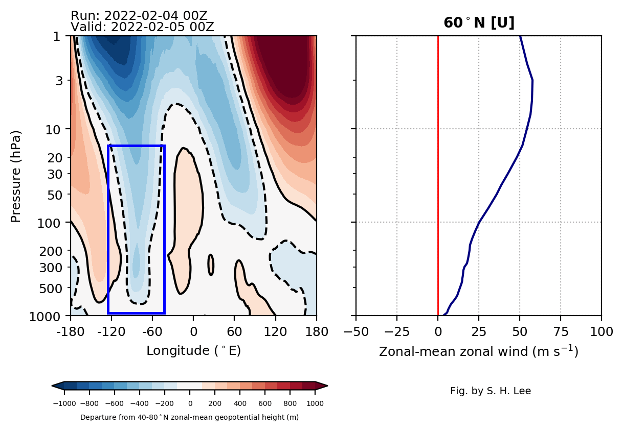
We can nicely see that if we look at the latest 5-day forecast of the pressure anomalies across the Northern Hemisphere. Notice the large area of lower pressure and strong circulation in the blue oval. That is the connected core of the polar vortex, also being driven by help from the stratosphere.

At the same time, a high-pressure area is dominant in the eastern Pacific and in the North Atlantic. That leaves a gap open over the eastern United States for the cold air to be transported down from the north.
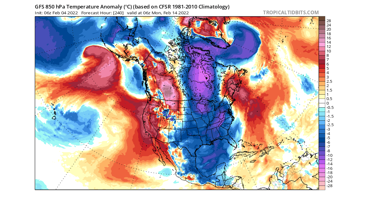
This is a special pattern of the lower level polar circulation. As the core circulation is stronger, it can also send more cold air and over a longer time period into the United States. On the forecast below we see a new cold wave spreading down into the eastern and southern United States in the next few days.

Taking a closer look at North America, the coldest air is moving over the midwest into the northeastern United States. A breakoff of cold air will spread partially into the southern United States. Warmer than normal weather will briefly move in over the west into central states.

FROM COLD TO COLDER
Going ahead into late next week, we can see the polar vortex being pressed from the North Pacific. It will increase the wind speeds in the surf zone of the polar vortex, but its core will not move much. It stays well organized and stronger than normal for this time of year.

Looking at the lower stratosphere levels at 50mb, the core is remaining strong. We can see a push from the North Pacific. But the unusually strong and cold-core retains the location and connection downwards.

Looking again at the NASA analysis for the Northern Hemisphere, we now have the minimum temperatures at 50mb. We can see the constant cooling, forecast to reach coldest temperatures for this time of year in the past 4 decades.

The NASA analysis for the wind speed at 50mb level (19km/12mi) shows the increasing wind speeds in the polar vortex at this level. Strengthening continues along with colder temperatures, creating one of the strongest polar vortex events in the past 40 years.
Going into mid-February and valentines week, the pressure patterns will not change much. The low-pressure system in northern Canada will cycle again, pulling down another wave of colder air into the eastern United States. This is the same main system that is connected to the core of the stratospheric polar vortex.

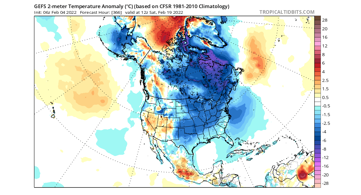
The temperature forecast for this period shows the active transport of colder weather down into eastern and the southern United States. Warmer than normal air is returning to the western United States, as the higher pressure expands from the North Pacific.

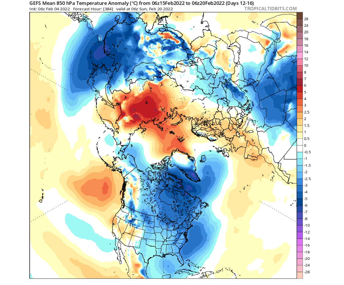
The colder airmass will accumulate and spread from north Canada directly down into much of the central and eastern United States. Below is a temperature anomaly weather forecast for Valentine’s day, showing one of the likely weather scenarios with cold over much of the central and eastern United States.
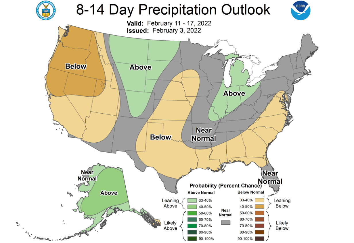
NOAA OFFICIAL 8-14 DAY WEATHER OUTLOOK
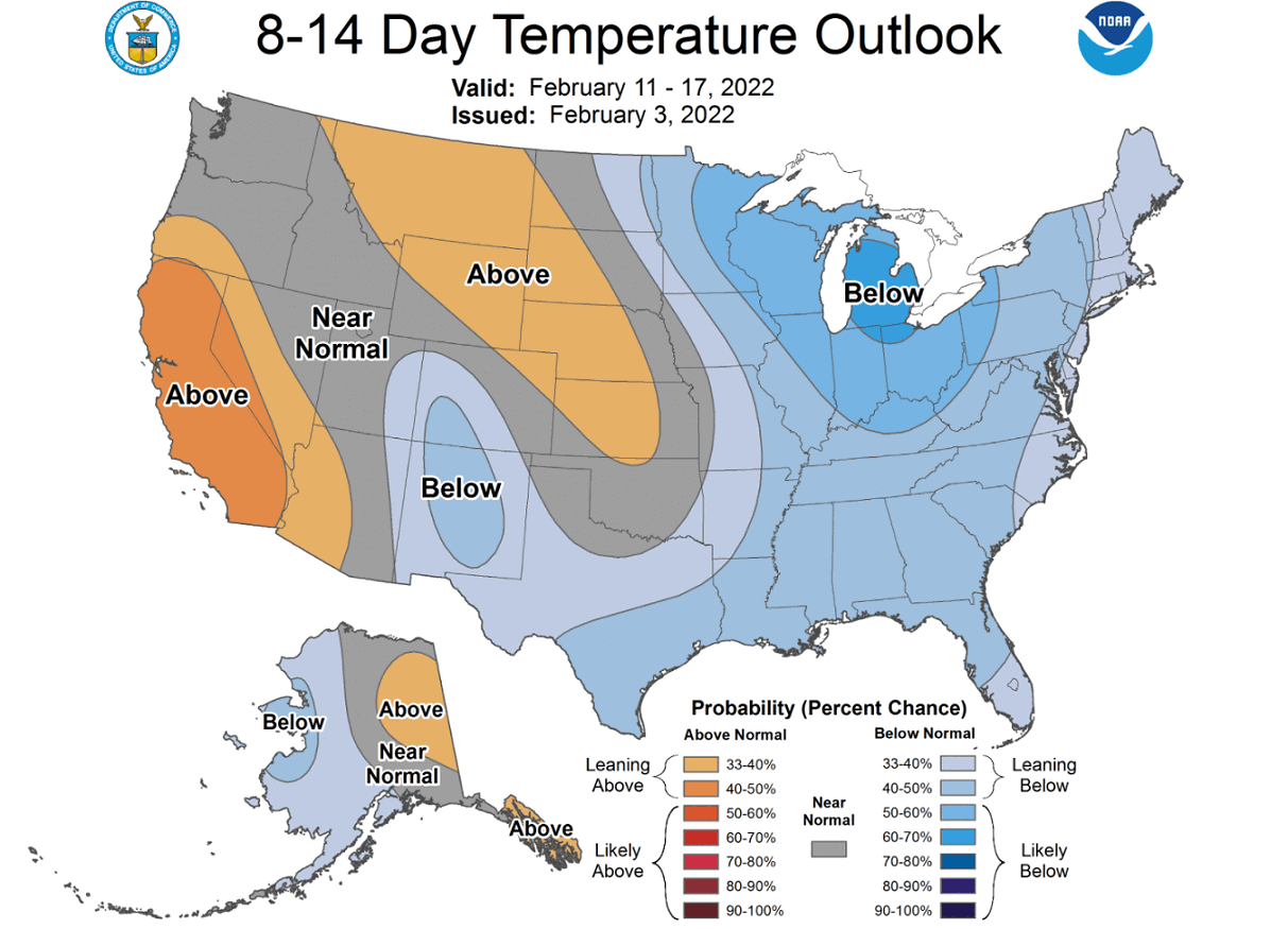
This is all nicely captured below on the official NOAA/CPC 8-14 day forecast for the United States. Colder temperatures will prevail over much of the eastern half of the country. Warmer than normal temperatures will prevail in this period in the west, under the influence of the high pressure from the North Pacific.
Looking at the official NOAA precipitation forecast, we more precipitation than normal over parts of the northern United States and the Ohio valley. Less precipitation is expected under stable air in the west and under the drier airmass in the Gulf states.
POLAR VORTEX AND THE WINTER WEATHER
Below we have a wind speed forecast for the atmosphere up to around 50k/31mi altitude. We can see strong wind speeds in the stratosphere (from 100mb up to 1mb level). There are no hints in the next 2 weeks of any slowdown of the polar vortex in the stratosphere.
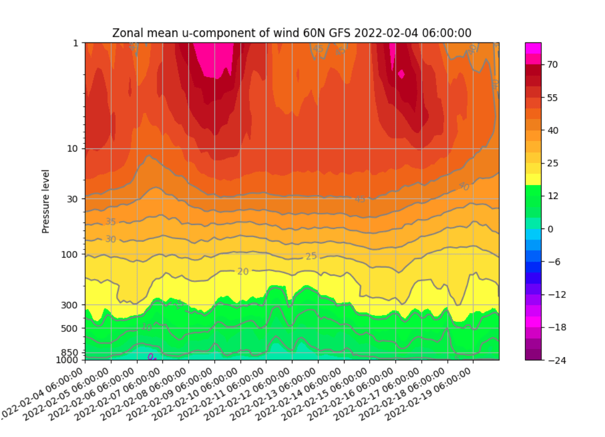
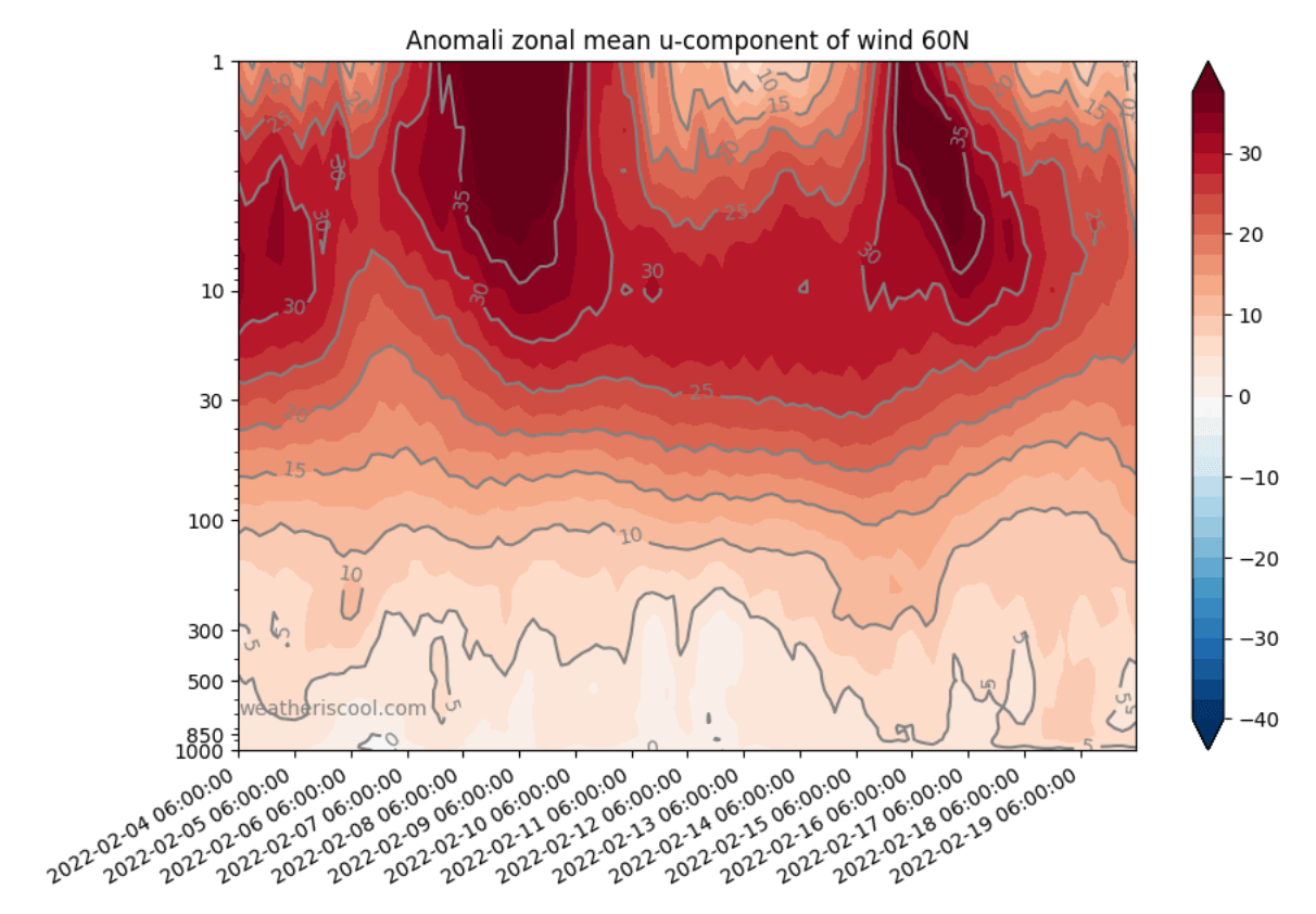
Looking at the same graphic, but at the anomalies. This shows us where the wind speeds are weaker/stronger than normal. We can see a scary picture in the stratosphere. The polar vortex is heavily stronger than normal as far as the forecast goes into late February. This will also have implications for the Spring season.
In the next graphic below, we have the pressure anomalies in the atmosphere shown over time in the Northern Hemisphere. Higher numbers (blue colors) mean low pressure and stronger polar vortex strength.

Notice in the forecast part of the polar vortex goes into “overdrive”, reaching +4 index value, which is unusually strong for this time of year, or any part of the year. We see an attempt of a full connection down to the lower levels in mid-February.
POLAR VORTEX OVERDRIVE
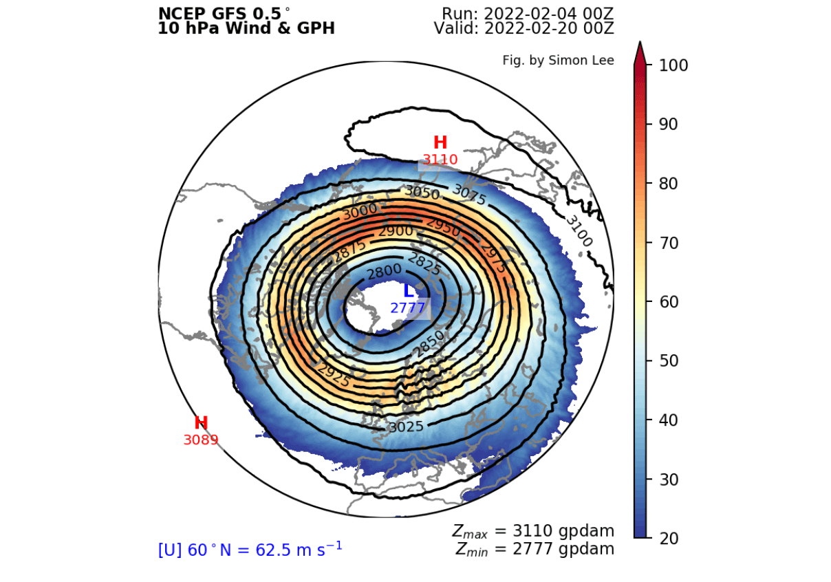
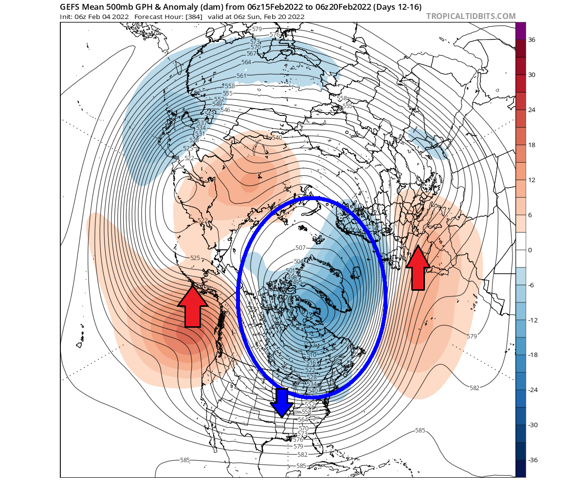
Going into the second half of February, we can see that the polar vortex will regain its near-perfect circular shape. That tells us two things. First, its strength has increased, and the external influence is weak. This basically means the polar vortex is free to spin up.
At this time, the lower stratospheric polar vortex will get elongated again, extending back down into North America. The level on the image is at 50mb. A surface high-pressure area in the North Pacific will press into the vortex at lower levels, elongating its shape, while the core stays very strong.
The vertical pressure anomaly profile reveals the core connection remaining in the north Canada area. A direct connection in the -60 to -90 Longitude is observed below, exactly where the low-pressure system over eastern Canada can be found.
This connection has been a regular feature in the past weeks, helping to drive the cold winter weather down into the eastern United States. A strong polar vortex core over northern/eastern Canada has been pumping down colder air in the northerly flow.
Looking at the lower pressure patterns, the ridge over the western United States and Alaska will remain, helping to stabilize the northerly winter flow into eastern parts of North America. The low-pressure zone will further stabilize over north Canada/Greenland, powered also by the polar vortex in overdrive.
Due to the low-pressure system over the Greenland area, a high-pressure zone in the North Atlantic will also be a stable feature. It will help to bring milder winter conditions into central and southern Europe and unsettled winter weather to the northern regions.
The sea-level pressure anomaly forecast below shows exactly what a takeover from the polar vortex looks like. As it spins up in the higher levels, it eventually takes over the lower parts of the atmosphere. Creating a low-pressure circulation zone over the polar circle, it will now be harder and harder to get the colder air out of the polar regions as we go towards the end of the winter season.
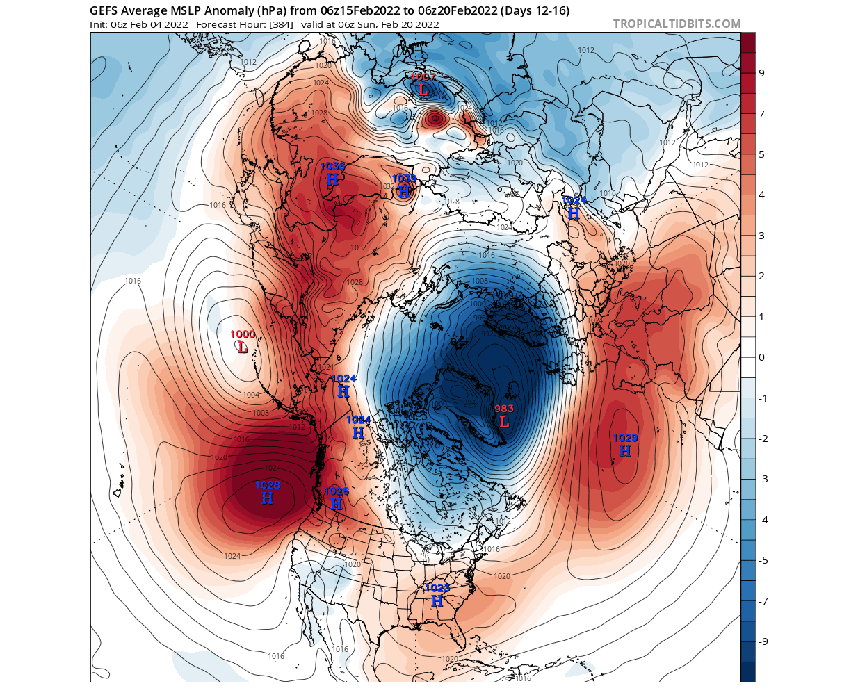
Looking at temperature anomalies for this period, we still have a cold air transport active at this time from Canada into the eastern parts of the United States. If the polar vortex will power up to the forecasted levels, it will eventually start to lock out these regular cold air outbreaks into the eastern United States.
Looking at surface temperature anomalies, the weather progression in this period is looking similar to the end of January, with another round of colder air coming down from the north. Spreading from the Midwest into the central and southern United States and moving towards the east. Below is the ensemble forecast, showing a likely weather scenario.
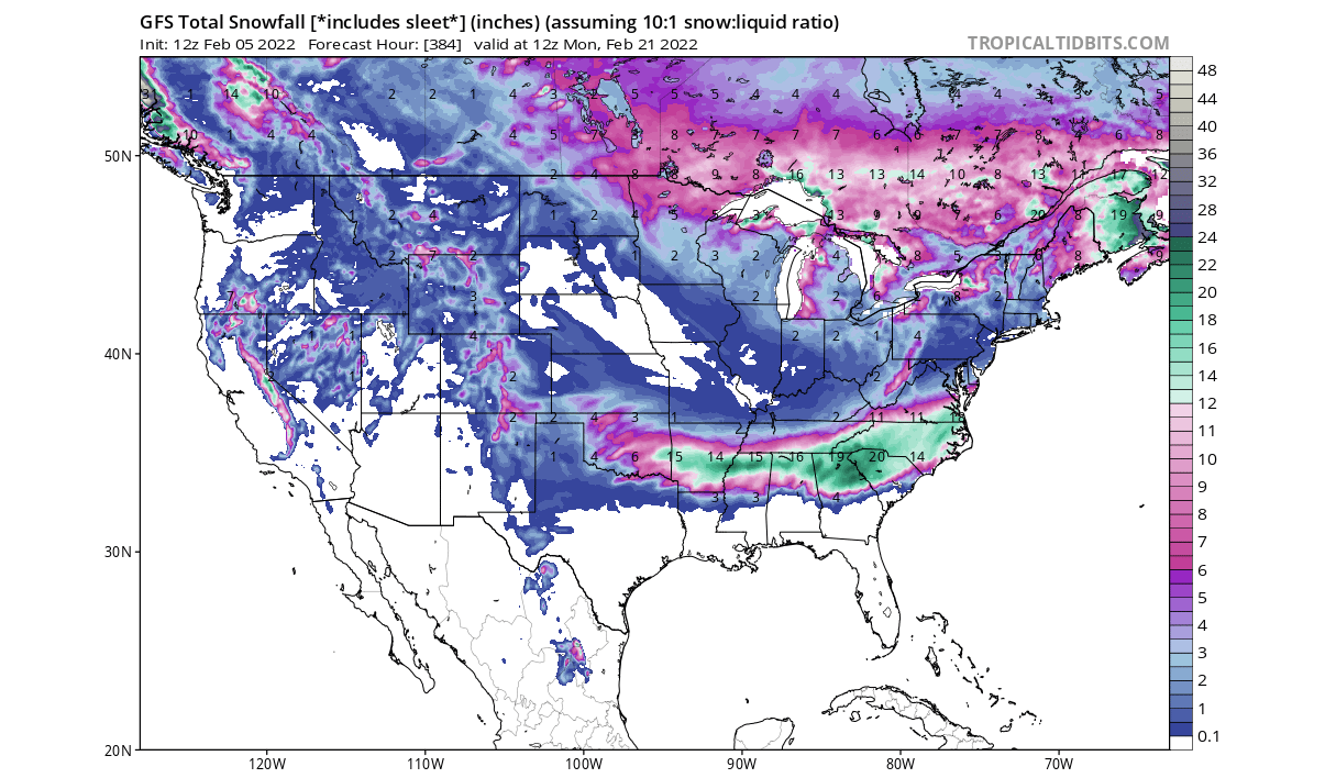
The snowfall forecast for the entire two-week period ahead shows snowfall over much of the eastern United States, and also in the south-central states. This is just a single model forecast, but it shows how the stable cold air transport enables to extend the snowfall far down to the south while still active.
It is quite remarkable, how despite a strong stratospheric polar vortex, the lower level weather patterns are able to respond to it and take advantage of that power to boost the colder winter air transport into the United States.
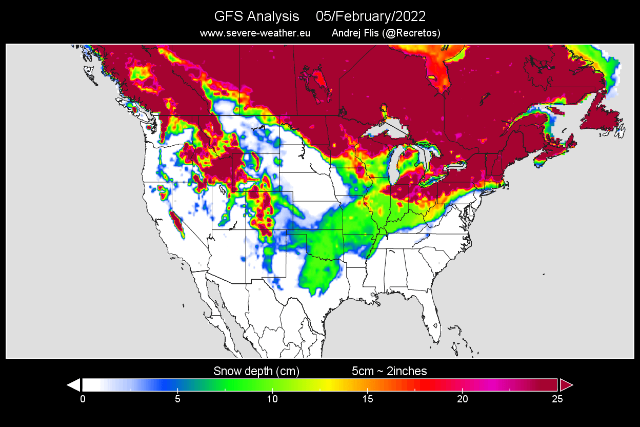
The current snow cover analysis over the United States shows quite an extensive snow cover. The most impressive is the snow extension down into the south-central states, reaching all the way from Ohio Valley down over Oklahoma and Texas.
But things look to be stabilizing as we head deeper into the late month. February is the final winter month, and the first signs show that winter weather could also be ending son along with the meteorological season.
WINTER COMES TO AN END
Meteorological seasons cover 3-months, divided into periods based on the temperature cycle. So Winter covers the 3 coldest months, Dec-Jan-Feb and Summer covers 3 warmest months, Jun-Jul-Aug.
In-between we have the transitional seasons of Spring and Fall. The meteorological spring season covers the Mar-Apr-May period. So with March, the meteorological Spring will officially begin. But what about in the real world?
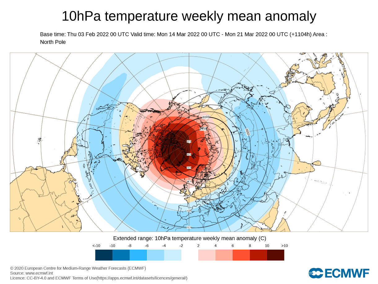
The latest extended-range forecast from ECMWF was released on Thursday, so we can look at some March trends. First, we need to look at the state of the Polar Vortex. Below is the forecast for the stratospheric polar vortex, which shows warmer anomalies over the polar regions in early March.

This shows an obvious weakening sign temperature-wise, as the sunlight returns to the polar regions, increasing the temperatures in the stratosphere.
The extended-range polar vortex wind forecast below shows a more gradual power drop as we go into March. This is a typical seasonal weakening of the polar vortex, with little signs of a premature breakdown event. The seasonal forecast spread is still high, so we will see adjustments in the next updates.

The corresponding lower pressure pattern for early March shows the higher pressure remaining over the North Pacific. A broad low-pressure zone remains over northern and western Canada, reaching into the northwestern United States. Low-pressure also takes over the North Atlantic, building high pressure over Europe.

The temperature forecast for North America shows the colder temperatures extending over most of the central and eastern United States. A low-pressure area over the west usually means a warm southerly flow into the eastern half of the United States, as seen on the ECMWF forecast below.
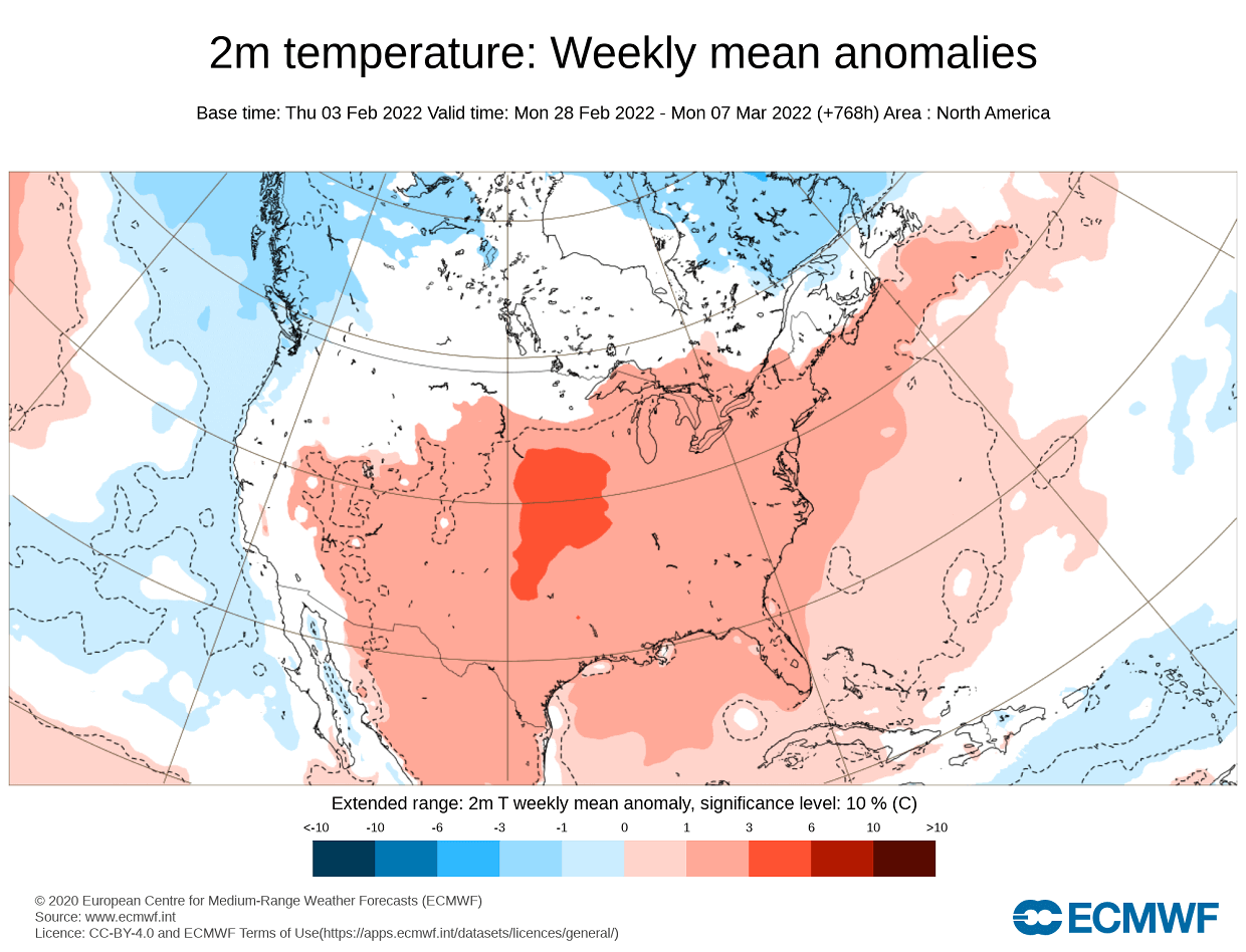
Towards the late month, we are starting to see that the low-pressure area is closing out over eastern Canada and Greenland. This is a continuation of the pattern from the early month. it sustains higher pressure into southern and eastern United States. A pattern like this can result when a strong polar vortex in the stratosphere takes over the lower polar circulation.

Temperature trends for this period show continuation of warmer anomalies over much of the central and eastern United States. But this pattern however still permits occasional drop of cold air from the north, but not to a degree that it would be seen in the forecast average at this range.
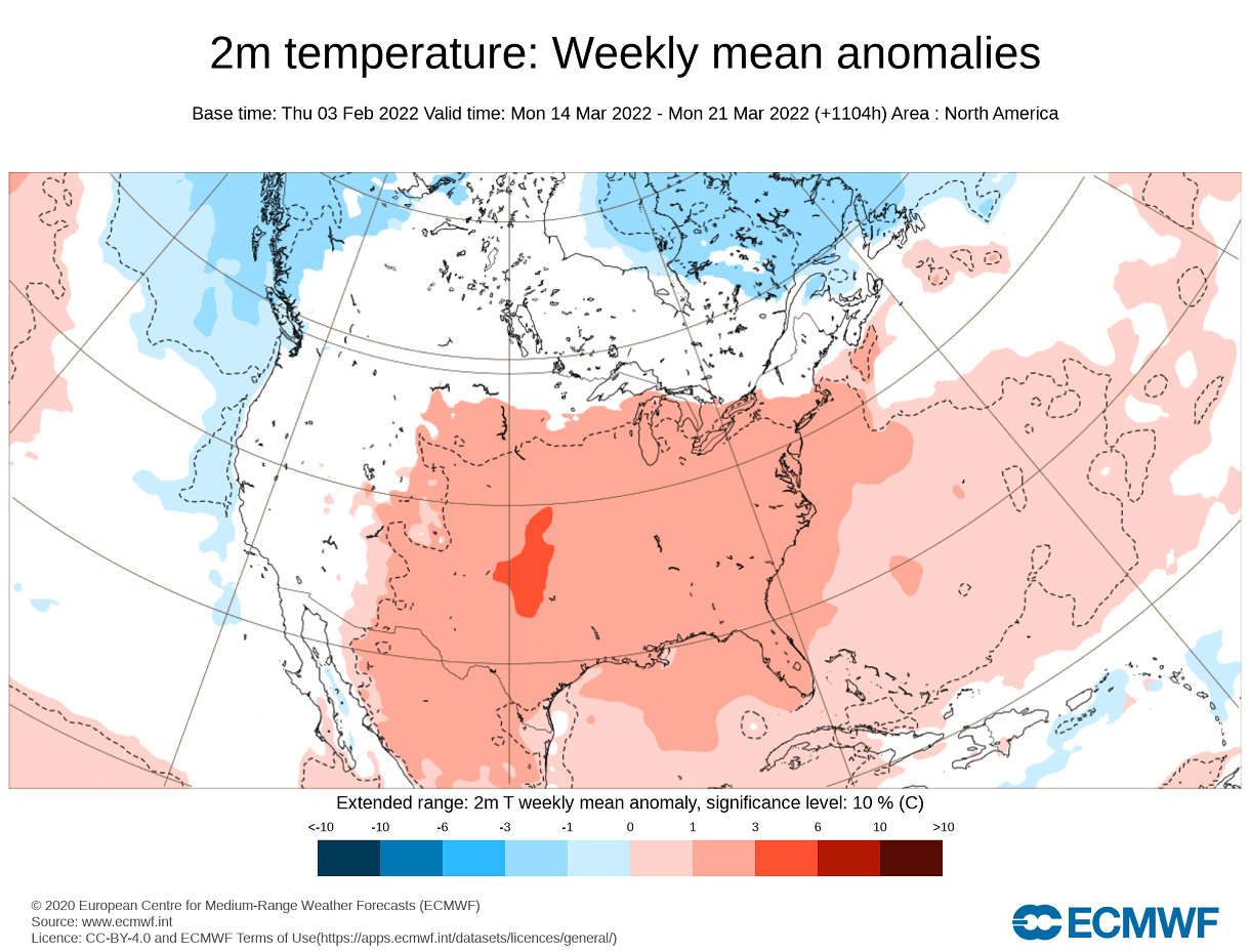
As we go into late March, the sunlight gets higher over the North Pole, further increasing the temperature in the stratosphere. This means that the polar vortex is weakening, as the temperature difference with the south decreases. The polar vortex is seen shifting to the Siberian sector as warmer than normal temperatures appear over the polar regions.
It remains to be seen how the polar vortex slows down this season. But it can have a huge impact on the weather development over the course of the spring season.
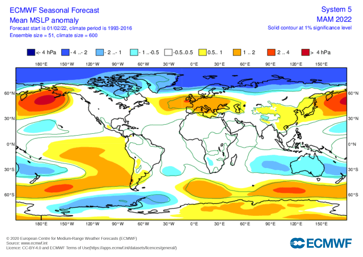
Below we have the very latest EMCWF seasonal pressure forecast. It shows surface pressure anomalies for the Mar-Apr-May season. We can see strong low-pressure anomalies over the polar regions. This implies a strong polar circulation, likely driven by the unusually strong polar vortex that is currently developing.
We will release regular weekly and monthly updates on weather development, and also a more detailed look at the latest Spring season trends. So make sure to bookmark our page, and also, if you have seen this article in the Google App (Discover) feed, click the like button (♥) there to see more of our forecasts and latest articles on weather and nature in general.
SEE ALSO: