Spring season 2022 will soon begin, with forecasts revealing the jet stream pattern over the North Pacific and the Atlantic to be influenced by the strong Polar Vortex and the collapsing La Nina. A high-pressure system in the Pacific will define the dynamic weather over North America, while a westerly flow is most likely for Europe.
When trying to understand any weather season and the forecasts, we must realize that there are many global drivers that can shape it. Global weather is a very complex system, with many large-scale and small-scale climate influencers.
Of course, we are not looking at the actual temperature and precipitation from city to city, as that is impossible. But we will look at the large-scale pressure systems and the jet stream over the Northern Hemisphere, which will be shaped by the Atmosphere and the Oceans.

WINTER SEASON COMING TO AN END
Most of the meteorological winter season is already behind us. We will quickly look at how it looks so far with monthly temperature anomalies and the pressure pattern over the Northern Hemisphere. The meteorological winter season covers the December-January-February period, so meteorological winter officially ends with February.
Below we have the pressure pattern from December 1st to February 14th. What stands out is the strong semi-permanent high-pressure system in the North Pacific. Also, as a response to that, we have a broad low-pressure area over western Canada, covering also the northwestern United States and Alaska.
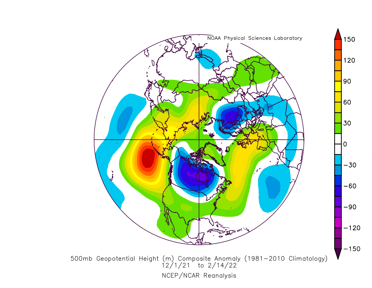
Such a pattern pushes the jet stream down into the northwestern United States and back up over eastern Canada. That helps to develop and sustain a ridge over the southern United States, bringing milder/warmer conditions to the southern United States, and colder weather to the northern half.
Over Europe, we have a ridge present over western Europe up into the North Atlantic. That means a low-pressure area is to the east of the ridge, bringing colder weather into Scandinavia.
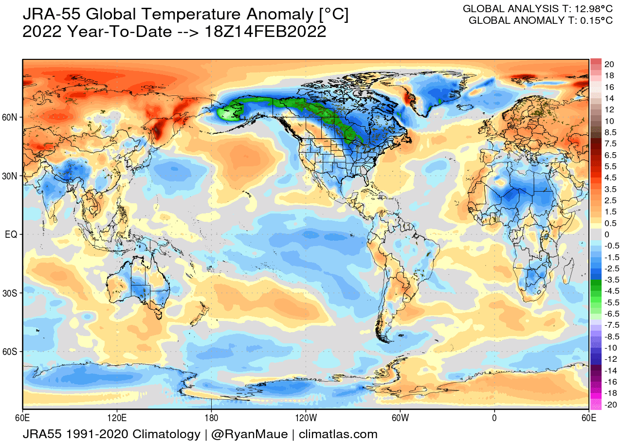
Speaking of temperatures, below we have the global temperatures for the same period. We can actually see a lot of warm anomalies in the polar regions, north of the 60N latitude. What stands out is a large and strong cold pool over Canada.

Most of Europe and the United States are under warmer than normal conditions. But the second half of the winter season has featured cold air outbreaks into the eastern half of the United States. In Europe, there were not enough cold air outbreaks to change the warmer average.
Below we have the global temperature anomaly analysis for 2022 so far. We can see a different picture, with the main difference being the extension of colder air from Canada down into the eastern and parts of the southern United States.
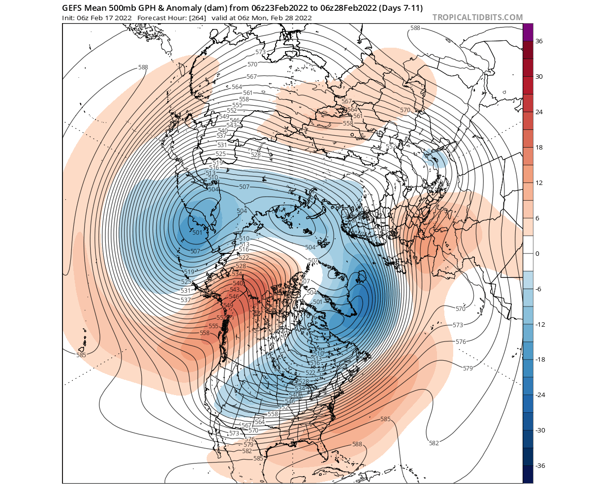
The meteorological winter season officially ends on February 28th. So looking at the weather pattern for the rest of winter, we can see a strong ridge over western Canada and Alaska. A low-pressure area extends from the western United States, towards Greenland, and into northern Europe.
Looking at the temperatures for the rest of winter, we see mainly warmer than normal temperatures over Europe, with the exception of the southeastern regions. Over North America, we can see a strong cold air outbreak developing later this week, which will cover most of the United States by the end of the month.
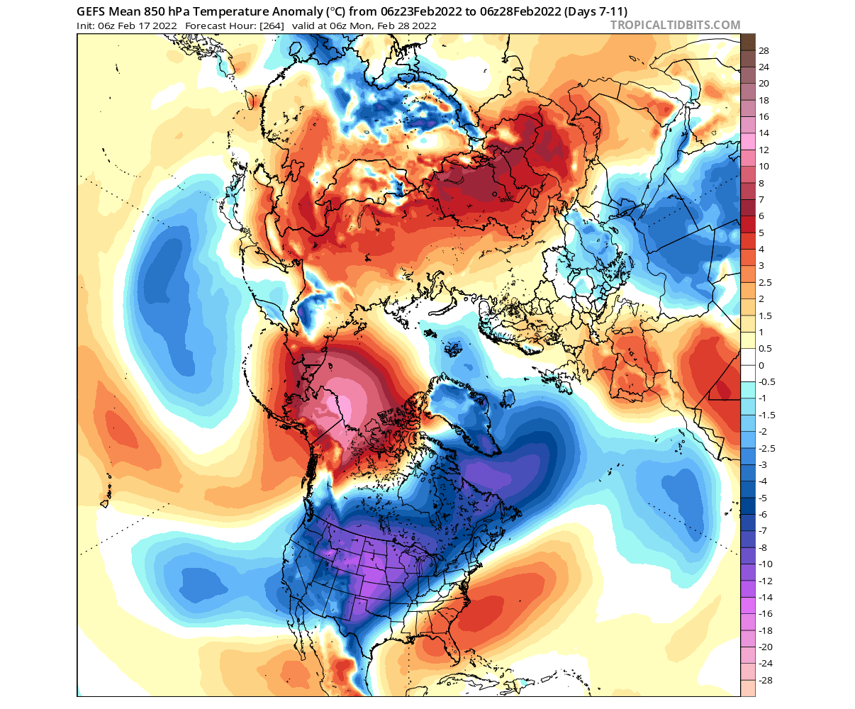
This will be the last major cold air outbreak of the 2021/2022 winter season. With March 1st, the meteorological spring begins, covering the March-April-May seasonal period.
But what was driving the weather this winter? And will it continue into Spring? We will now look at the main drivers behind the weather patterns this cold season, and how they will influence the weather development in Spring 2022.
BETWEEN THE OCEAN AND THE ATMOSPHERE
Whenever we look at the seasonal forecasts and large-range trends, we always have to look at the large-scale climate drivers. That has obviously been the La Nina in the tropical Pacific Ocean.
But once the season starts, we tend to look more at the short-term variability. Besides the La Nina which we will also cover shortly below, we have one other driver of the weather in the Northern Hemisphere. The infamous Polar Vortex.
THE POLAR VORTEX
Every year as we head into autumn, the polar regions receive much less sunlight. This way, cooling begins over the north pole. But as the polar temperatures drop, the atmosphere further south is still relatively warm as it continues to receive energy from the Sun.
You can see the winter solstice in the image below. The polar regions receive little to zero solar energy, compared to regions further south, which still continue to receive plenty of sunlight.

So, as the temperature difference towards the south increases, this also means pressure difference. Due to this pressure difference, a large low-pressure (cyclonic) circulation starts to develop across the Northern Hemisphere from the surface far up into the stratosphere. This is known as the Polar Vortex.
While the stratospheric polar vortex is spinning high above our weather, it is still directly connected to the lower part and can shape our daily weather in one way or another, as it is all one large hemispheric circulation.
The image below shows a typical example of the upper Polar Vortex at around 30km/18.5miles altitude in the middle stratosphere during winter. It has a very nice circular shape, with the temperature dropping quickly towards its inner core.
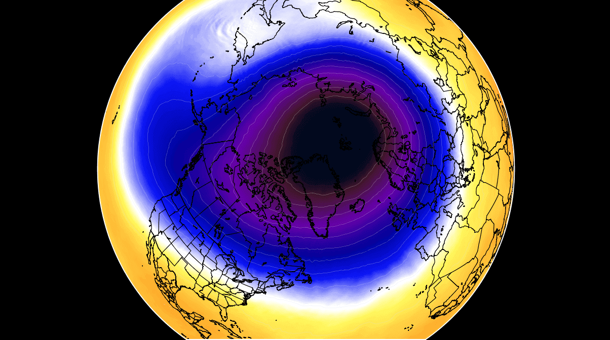
It is basically like a very large cyclone, covering the whole north pole, down to the mid-latitudes. It is strongly present at all levels, from the ground up, but can take on different shapes at different altitudes.
In the next image below, we have the polar vortex at a much lower altitude, around 5km/3miles. The closer to the ground we go, the more deformed the polar vortex gets because it has to interact with the mountains and overall terrain and also with the strong weather systems.
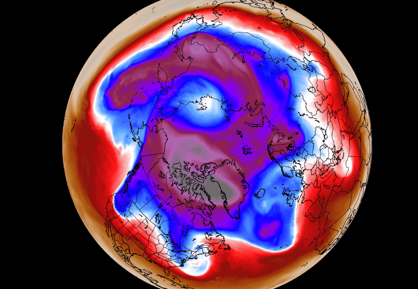
Be aware of its “arms” extending into the lower latitudes, bringing along colder air and snowfall into the mid-latitudes. These arms also pack a lot of energy and can create strong winter storms, either Noreasters in the United States or powerful wind storms in the North Atlantic.
We are typically focusing more on the Stratospheric Polar Vortex, as it plays a very important role in the weather development throughout the season. It is known for its strong influence down from the stratosphere, in either direction, for a cold or warm winter.
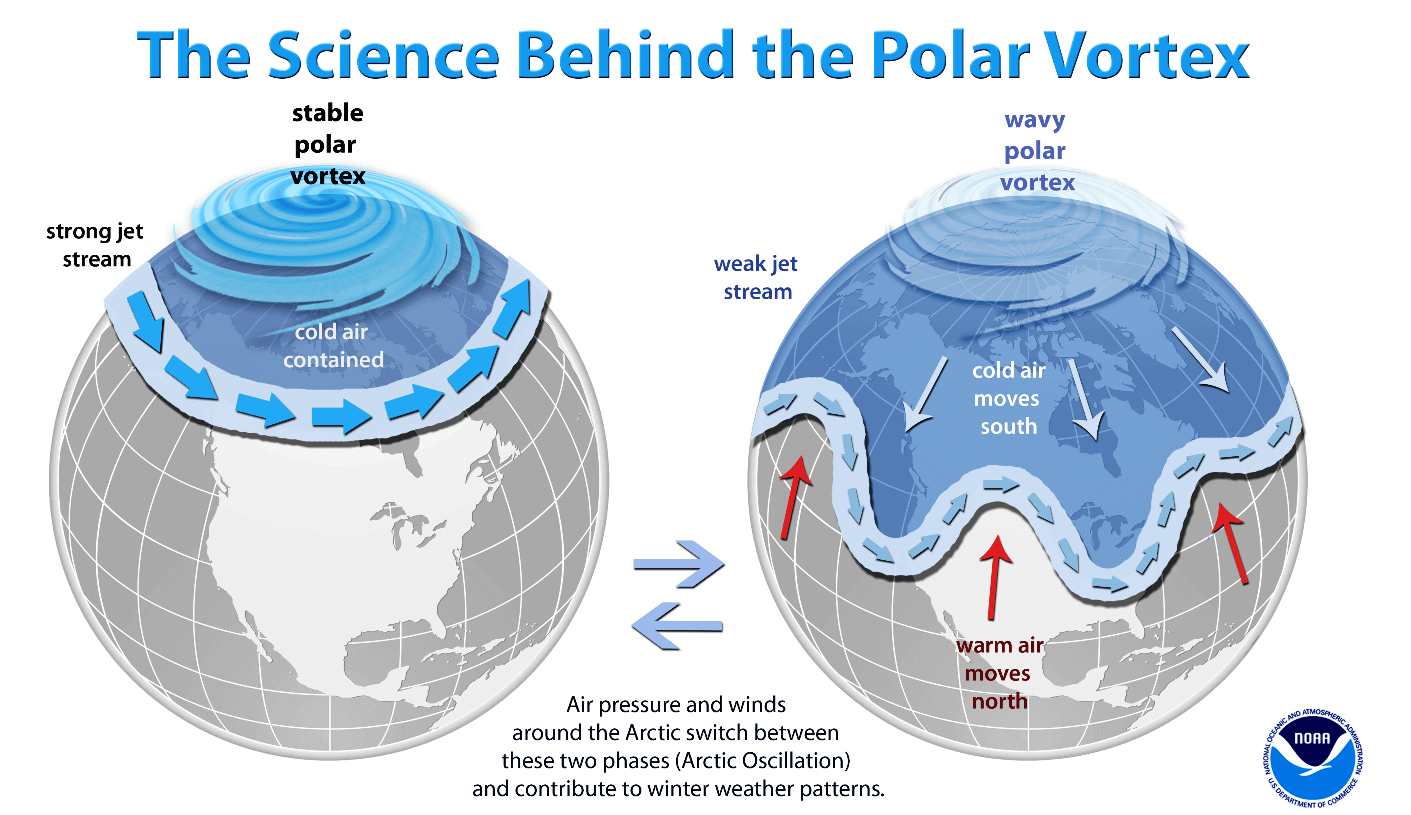
A strong Polar Vortex usually means strong polar circulation. This usually locks the cold air into the Polar regions, creating milder weather for most of the United States and Europe.
As a contrast, a weak (wavy) Polar Vortex can create very dynamic weather. It has a much harder time containing the cold air, which can now escape out of the polar regions, into the United States and/or Europe. Image by NOAA.
Below we have a zonal mean (average) temperature for 2021/22, at the 50mb level from NASA. You can see a steady cooling, continuing with a strong pace in the past weeks. The data shows that the temperatures at this level have reached record cold values in the past few days.

The NASA analysis for the wind speed at 10mb level (30km/18.5miles) shows the increasing wind speeds in the polar vortex at this level. Strengthening continues along with colder temperatures, creating one of the strongest polar vortex events in the past decades.

Looking at the seasonal forecast from ECMWF, we can have the wind speed forecast below. It shows the polar vortex continuing at a strong pace, being present well into the spring season. This means that it will play an important role in the weather development in the first half of the spring season.

As we have said above, a strong polar vortex tends to create a stronger circulation at the lower levels. This usually means lower pressure over the polar regions and the North Atlantic. This way, the colder air has a harder time escaping from the polar regions.
So by the forecast, we can see that the polar vortex will play its major role in the first half of the spring season. It will be stronger than normal most of the time, and also have another role as it finally collapses, with yet unknown effects on the circulation.
To put the polar vortex into a perspective, we produced a high-resolution video, which nicely shows the Polar Vortex spinning over the Northern Hemisphere in the stratosphere at the 30mb level, around 23km/14miles altitude.
Video shows the NASA GEOS-5 analysis for late January 2022. Notice how the polar vortex covers a large part of the Northern Hemisphere. You can see how it spins over the Northern Hemisphere, driving also the winter weather below with its circulation.
Now we are going from the atmosphere down into the oceans. There, another powerful dynamic has shaped the winter weather and will extend its influence deep into the Spring season.
COLD ENSO – LA NINA
ENSO is short for “El Niño Southern Oscillation”. This is a region of the equatorial Pacific ocean, changing between warm and cold phases. Typically there is a phase change in around 1-3 years.
ENSO has a major influence on the tropical rainfall patterns (storms) and the complex exchange between the ocean and the atmosphere. We observe large-scale pressure changes in the tropics with each new developing phase. With some delay, these changes affect the circulation over the rest of the world.
The image below shows the ENSO regions in the tropical Pacific. Regions 3 and 4 cover the east and west and together cover a large part of the tropical Pacific. The main region is a combination of regions 3 and 4, seen on the image as the Nino 3.4.

The cold ENSO phase is called La Ninaand the warm phase is called El Nino. Besides the temperatures, one of the main differences between the phases is also in the pressure state.
During an El Nino, the pressure over the tropical Pacific is lower, with more rainfall and storms.
But during a La Nina, the pressure over the equatorial Pacific is high, creating stable conditions and less precipitation. This obviously translates into the global circulation, affecting both Hemispheres differently with time.

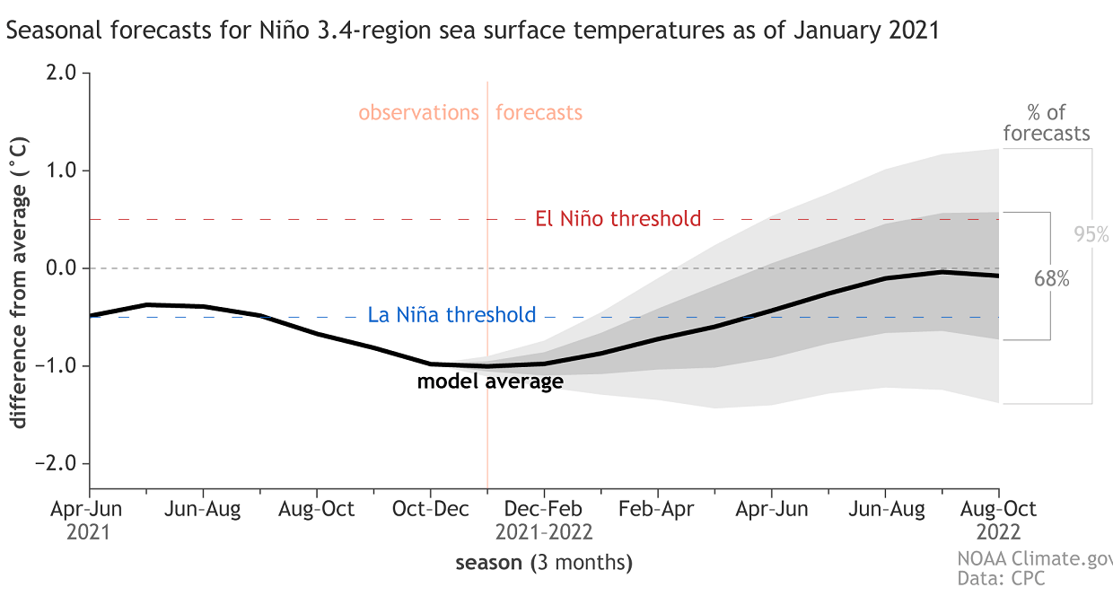
Below we have the latest global ocean temperature anomaly analysis from NOAA. We can clearly see the decaying cold anomalies in the tropical Pacific Ocean. That is the current La Nina phase slowly weakening. The strongest cold anomalies are currently found in the eastern parts, but weakening over time.
The forecast calls for the La Nina to end towards late Spring 2022. This is a typical scenario, with a transition to a neutral state during the warmer part of the year. Typically a new phase tends to develop in late summer or early fall. Image below by NOAA Climate.
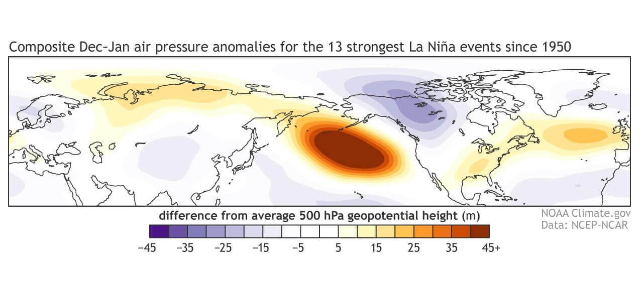
Below we have the average cold season pressure pattern, from multiple La Nina seasons. The main takeaway is a strong high-pressure system in the North Pacific and low pressure over Canada. That is the typical fingerprint of the cold ENSO phase. Over Europe, we see high pressure over Scandinavia and northwestern Europe.
This high-pressure system from the La Nina, combined with the strong Polar Vortex, is what will be running the show during the Spring season. We will be looking for their combined influence in the next section, which will reveal the latest long-range weather forecast trends for Spring 2022.
SPRING 2022 – SEASONAL WEATHER FORECAST
We now know what La Nina is and the Polar Vortex, and how they can change the jet stream and our weather. Now we will take a look at the global long-range models, and how they see the upcoming Spring 2022 season.
As ususal, we will focus on the 3 main (or most used) seasonal models. The ECMWF and UKMO from Europe, and the CFSv2 from the United States. Graphics are from the Copernicus Climate EU project and the CPC/NCEP.
All these forecasts show an average pattern over the course of 3 meteorological spring months (March-April-May) and show the prevailing weather development.
Even if the models would be completely accurate, it does not mean that such weather conditions would last for 3 months straight. It only suggests how the weather patterns might look 40-60% of the time.
ECMWF SPRING SEASON FORECAST
We will look at the ECMWF first, as is often referred to as the most reliable model in the long-range category. In reality, a lot depends on the individual years/seasons. But generally, the ECMWF model is at the top as far as reliability goes.
But no long-range/seasonal forecast can ever be deemed “reliable“, as we are only looking at trends and how the weather patterns are evolving on a large scale and longer time periods.
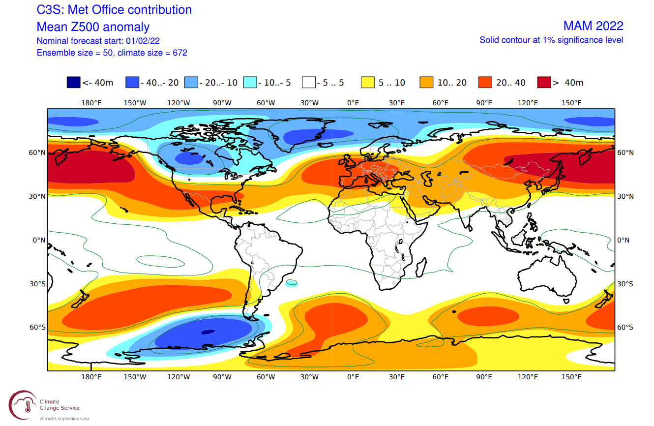
In the pressure pattern forecast from ECMWF below, we can see the typical La Nina high-pressure system in the North Pacific. The low-pressure system is present over western Canada and expanding into the Greenland area and the polar regions, signs of a strong polar vortex.
The jet stream is bending in between the high and low-pressure systems as we have seen in the previous segment.
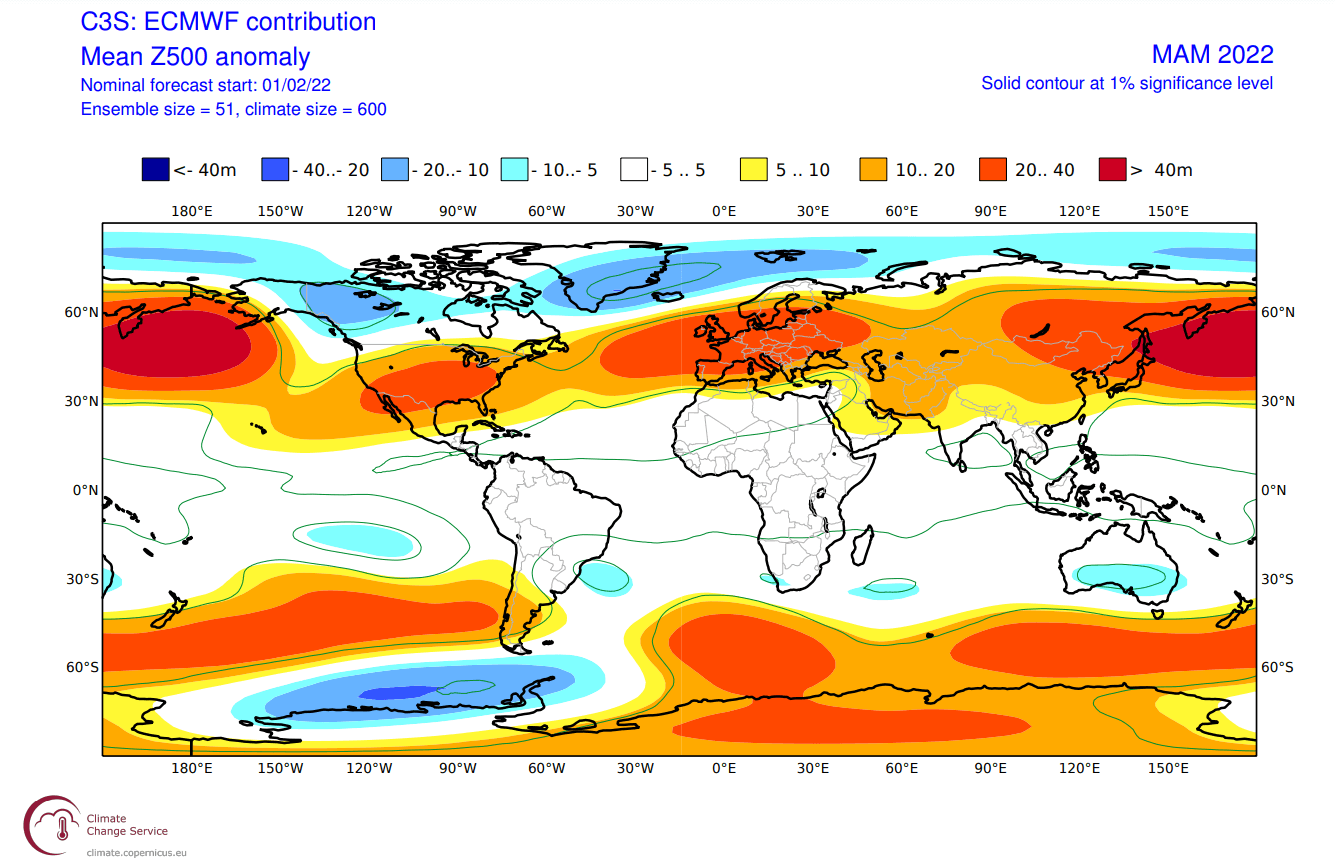
We see the North Atlantic in a positive North Atlantic Oscillation (NAO) mode, which means an amplified jet stream over the British Isles and into Scandinavia. A positive NAO can result from a strong polar vortex, and generally means mild/warmer conditions for Europe and the southeastern United States.
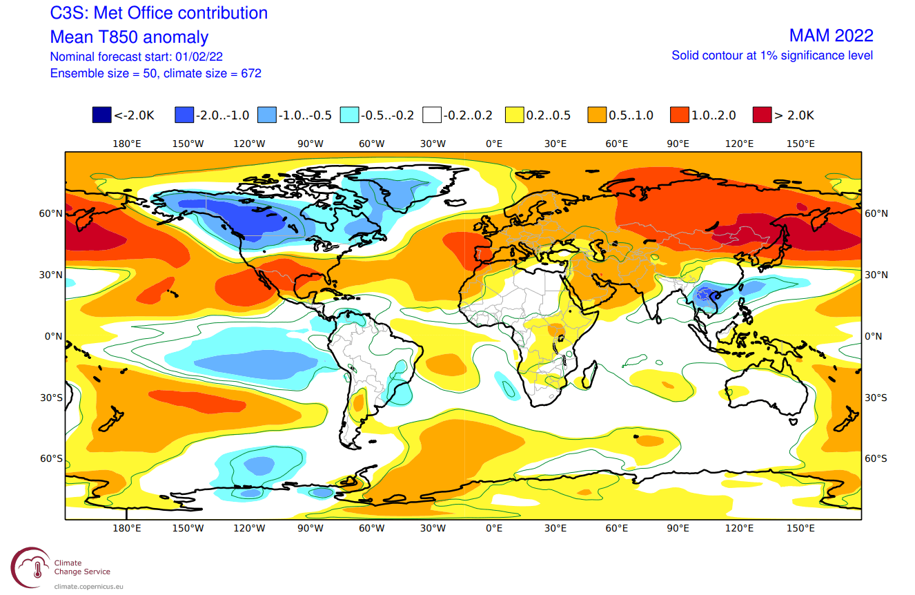
The airmass temperature forecast below shows North America divided into two parts. Western Canada is forecast to remain colder than normal. Thanks to the jet stream, there is a high chance of the colder air extending south, into the parts of the northern United States, over the Midwest into the northeastern United States. The Southern United States is forecast to be warmer than normal.

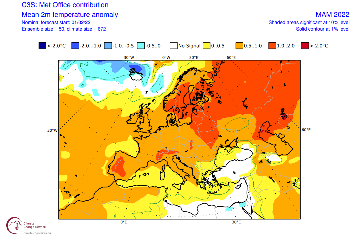
Europe also features higher than normal temperatures. A more westerly flow dominant scenario is the most likely solution, especially with the stronger polar circulation.
Looking closer at Europe, we see the surface temperatures are mostly above normal. Some colder anomalies are seen in the far North Atlantic, where the low-pressure systems will be found. Far southeastern Europe is also forecast to be colder than normal, due to a more northerly flow.

Over North America, the ECMWF forecast shows colder than normal surface temperatures in Alaska and western Canada. We do see an indication of colder air intruding into the northwestern United States. The rest of the country is mostly warmer than normal.
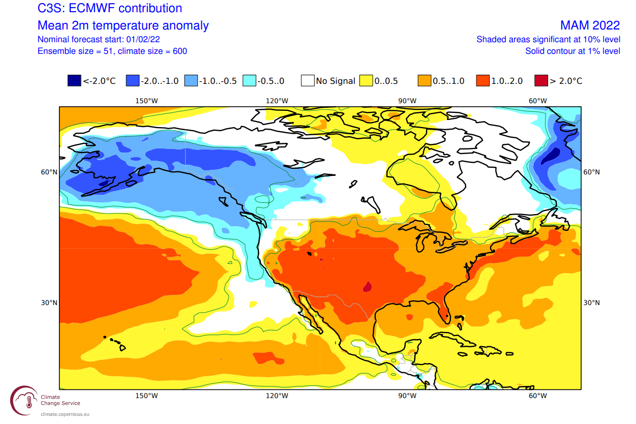
Notice a weaker warm anomaly in the eastern United States. That indicates a window for colder air from the north to spill into the eastern United States. A higher chance for that is in the early parts of the spring.
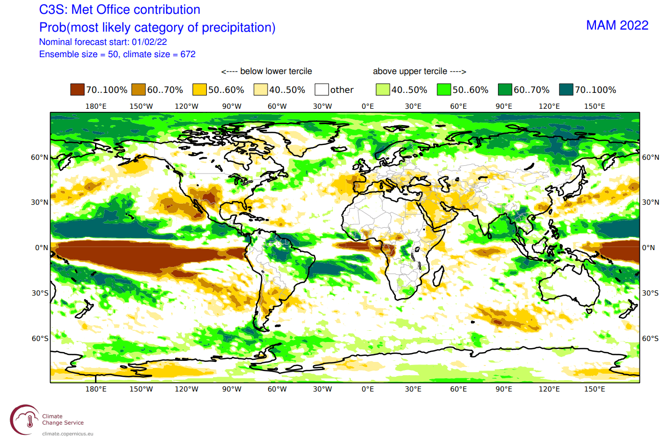
The precipitation anomaly forecast below shows a more normal La Nina type pattern over Canada and the United States. We see the mainland United States with wetter conditions in the northwest and the east, and drier conditions in the southwest and over Florida.

Europe is trending to have more precipitation over the northern regions, following the jet stream and low-pressure systems. Drier conditions are forecast for most of mainland Europe, under high-pressure systems.
UKMO SPRING FORECAST
Our second model of choice is the UKMO model, from the United Kingdom Met-Office. This has also been a good performer in the past seasons, so we tend to include it in our standard “suite” of long-range model forecasts.
UKMO has a similar pattern as the ECMWF, with a stronger low-pressure zone over Canada and the North Atlantic. It shows the same strong La Nina blocking high-pressure in the Pacific. This can also be due to the lower ensemble spread in the model.
This is a much stronger positive NAO pattern, creating an amplified jet stream into northern Europe and a stronger high-pressure zone over Europe.
The global temperature forecast also looks similar to the ECMWF. Over North America, we have the cold pool over western Canada and Alaska, but reaching down further into the northern United States. The southern and eastern United States is forecast to be warmer than normal.
Europe features mostly warmer than normal conditions, with a storm track further up over northern Europe.
Looking closer at Europe, we see warm anomalies over most of the continent. The pattern that UKMO suggests leaves little room for cold air intrusions. But we have seen cold air outbreaks every spring. What usually changes each year is the number of these cold outbreaks. UKMO also has a colder signal for southeastern Europe.
Over North America, the UKMO has a much colder signal than the EMCWF, due to the stronger low-pressure system in Canada. We see the cold anomalies extending down much further into the northwestern United States and the Midwest, compared to the ECMWF.

Warm anomalies are a certainty for the southern half of the United States. But a pattern that the UKMO shows, in a combination of the La Nina and a strong Polar Vortex, is a more likely scenario than the ECMWF.
The precipitation forecast shows the drier conditions over the southwestern United States. Northern and eastern parts of the United States have a higher chance of wetter conditions under the jet stream. Europe features higher precipitation over northern regions, due to the higher frequency of storms moving over this area.
CFSv2 SPRING SEASON FORECAST
In contrast to the European models, we tend to use the main North American long-range model, the CFS version 2 from the NOAA/NCEP in the United States.
The CFS model is closer to the ECMWF, with a strong high-pressure system in the Pacific and a weak low-pressure area over western Canada. It still creates a pressure/temperature difference between Canada and the southern United States, putting the jet stream over the northern United States.
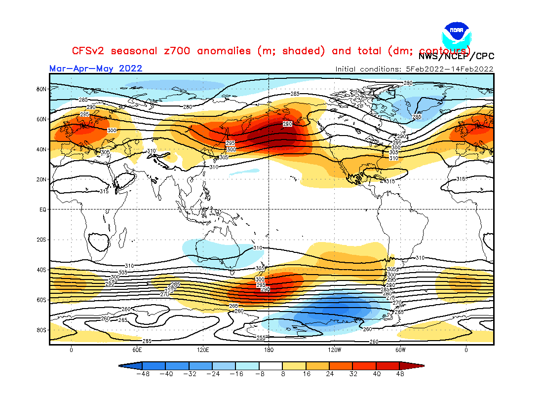
It shows the strong polar vortex circulation and an amplified jet stream in the North Atlantic. The main storm track is over Iceland, the British Isles, and Scandinavia. This is a typical positive NAO pattern, with high-pressure and warmer than normal weather over Europe.
Global airmass temperatures are most interesting over North America, with a cold air anomaly in western Canada and warmer air in the southern United States. Europe is seen warmer than normal, as expected with storms moving far out in northern Europe, locking out the colder air for most of the time.
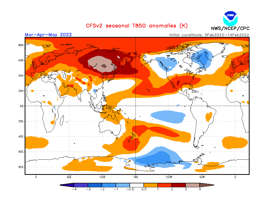
Looking closer at Europe, the surface temperatures are really warmer than normal over much of the continent, especially northern regions. This is very similar to the other two seasonal models presented above and seems to be a consolidated (high-reliability) forecast at this point.

The North American forecast below shows a similar pattern to the previous two models. Colder than normal temperatures remain over western Canada and the northwest United States and warmer than normal in the southern half of the country.

The CFS model kinda sits in-between the two European ones, as far as the temperature pattern in the United States goes. It is not as cold overall in the north as the UKMO but does not expand the warm anomalies as far north as the ECMWF.
Global precipitation forecast again shows drier than normal conditions over the southwestern United States. Northwestern and eastern United States is likely to have more precipitation than normal, due to the jet stream moving over the regions.

In Europe, we see mostly drier conditions across the continent. Wetter conditions are most likely for northern Europe, where the main storm track is forecast.
SPRING 2022 WEATHER FORECAST – SUMMARY
Reading images and descriptions can be confusing sometimes, so we have put together a simple Spring 2022 forecast summary:
Europe is expected to have mostly warmer than average temperatures over much of the continent. This, however, does not mean that there will be no cold fronts and colder days. It just implies that cold fronts and colder air mass intrusions will be less frequent over the continent.
The models are close in agreement over the low-pressure pattern in the North Atlantic. The main difference is the strength of the low-pressure over Iceland/Greenland. An average picture from all three models suggests lower pressure in this region, limiting the cold air intrusions into the continent.
This is also a likely result of the stronger Polar Vortex, creating an amplified polar circulation in early spring, lasting over the season.
Normal to wetter conditions are expected over northern Europe. The British Isles and Scandinavia could have a more unsettled spring, as the jet stream positions over these regions, bringing along stormy weather. Mainland Europe is expected to experience mostly drier than normal spring.
North America spring forecast looks fairly solid to be an extension of the winter pattern. Most of western and Central Canada is expected to have colder (and snowier at first) conditions, along with Alaska.
The Northern United States is expected to have normal-to-colder spring winter with more precipitation. This increases the chance of spring snowfall events. But that is more likely in the northwestern region and in the Midwest, with the lesser degree into the northeastern United States.
The Southern United States has a high probability of warmer and drier than normal spring weather. With the strong cold pool over western Canada, there is an active threat of more severe weather, as stronger than normal cold fronts come down to meet the warmer air.
The main channel of spring cold air outbreaks seems to be from the northwestern United States and the Midwest down into the central and eastern United States. Similar to what we were witnessing in the past weeks.
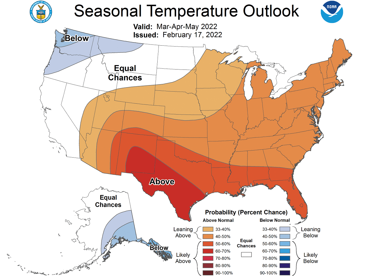
Below is the latest official Spring temperature forecast for the United States by NOAA. It shows the temperature probability, with colder to equal chances in the northern United States. The southern and eastern United States have a higher probability of warmer than normal weather, as seen in the models above.
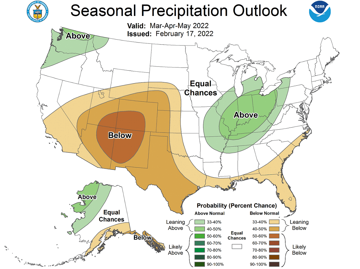
The official precipitation forecast is also quite similar to the model forecast. We see an equal-to-higher probability for more precipitation in the northwestern and the eastern United States. The southern United States is forecast to have a drier than normal spring season, especially in the southwest.
The problem with precipitation in any La Nina season is typically the persistence of drought conditions in the southern and southwestern United States. Below we have the latest drought analysis from NOAA, which shows the current drought conditions in the United States.
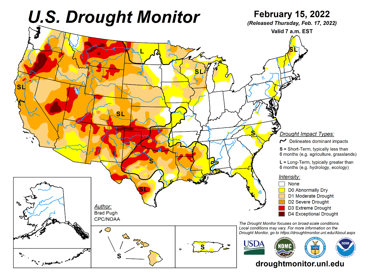
Most of the western half of the United States is under some level of drought conditions. The driest conditions prevail in the south-central states and in the northwestern United States.
Spring generally means that warmer temperatures are returning. But with warmer temperatures, the severe weather season also returns to the United States. We will quickly look at the latest pattern setup for the severe weather season.
2022 USA SEVERE WEATHER SEASON
As history shows, La Nina can also have a profound influence on the Spring tornado season in the United States. And usually not in a good way.
Below we have a very interesting image from NOAA Climate. It shows a frequency of hailstorms and tornado events during the spring season in the United States, compared between El Nino and La Nina years.
We can see that in a La Nina spring season, there is a substantially higher frequency of hailstorms and tornado events compared to an El Nino. The highest frequency is found in the southern and southeastern parts of the United States.

This nicely outlines the Tornado Alley. This is a nickname given to an area in the southern plains of the central United States that consistently experiences a high frequency of tornadoes and other severe weather events each year.
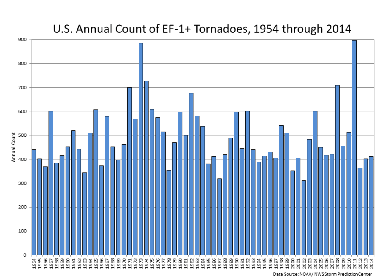
Below is a graph that also shows annual tornado numbers in the United States from 1954 to 2014. Looking at the years, we can see that from the top 5 most active tornado years, 4 were actually La Nina years.
But why are there more tornadoes and other severe weather in the southern United States during a La Nina?
A lot has to do with the weather pattern we have seen earlier during a typical La Nina season, promoting a high-pressure system in the North Pacific. That typically corresponds to the pressure drop over western Canada and the northwestern United States.
This can act as a source region for frequent cold fronts, which move from western Canada down towards the south-central United States. There the cold front meets warm moist air coming up from the Gulf of Mexico.
Thanks to the shifted jet stream, this produces a very volatile combination with a lot of available thermal and wind energy for the storms to become severe and tornadic.
The image below shows the April-May-June multi-model pressure pattern forecast. We can see the lower pressure over western Canada. This means an increased chance of cold fronts from the northwestern United States towards the south-central regions.

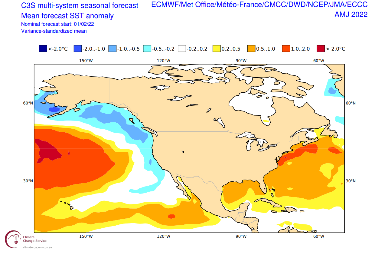
Looking at the sea surface temperature anomaly forecast, we can see warmer than normal waters in the Gulf of Mexico. This is very important, as higher water temperatures mean warmer air coming from the Gulf with moisture, increasing the severe weather potential, as it meets the cold fronts from the northwest.
We will release regular weekly and monthly updates as fresh forecasts and data are available. So make sure to bookmark our page. Also, if you have seen this article in the Google App (Discover) feed, click the like button (♥) there to see more of our forecasts and our latest articles on weather and nature in general.
SEE ALSO: