It looks like a neverending story of how unusually intense the Polar Vortex is this winter season. The Arctic cold pool just keeps spreading outbreaks of wintery weather towards the south across North America. Another one is shaping up this week, resulting in a significant, nearly 50 °F drop of temperature from tonight into to Tuesday. The cold blast will trigger two Winter Storms Nancy and Oaklee, leading to a busy winter weather week across the U.S., with snow to the northern half, rain, and severe weather on the south. In between, a swath of dangerous ice storm is also increasingly likely on Thursday, with a potentially destructive amount of ice from the mid-Mississippi to Ohio Valley.
An active winter and severe weather week are forecast across the U.S. again as another push of Polar Vortex southern lobe follows in the coming days. February 2022 is surely earning its name as the more active month across North America.
The first system through the early week will blanket the West and North, and bring severe weather for the central and South. While the second wave brings an ice storm and more snow on Thursday.
The Polar Vortex of 2022 has also been responsible for three consecutive windstorms that blasted across parts of Europe this week. Their origin came from the same source as we’re seeing over North America, the huge reservoir of extremely cold air mass over Arctic Canada, sliding down to the North Atlantic and triggering violent extratropical storms.
This time, a major blast of Arctic cold air will plunge from Canada towards the West, and central U.S. while the air warms up to the East and Southeast. Two large frontal systems, Nancy and Oaklee, will be in focus, both bringing winter and severe weather. The first, Winter Storm Nancy is urging weather alerts across the northern half of the U.S., from Oregon to the Midwest as a lot of snow and also near-blizzard conditions are forecast tonight.
Following the early week’s Nancy storm, another potentially more significant winter storm Oaklee will follow on Thursday and Friday. Storm Oaklee is forecast to bring wild winter weather with snow and icy conditions across the central parts of the country. With a huge reservoir of frigid, Arctic cold in its wake.
Another concern with this week’s Arctic intrusion is also a swath of severe weather potential across the central and southern U.S. Dangerous severe storms with tornadoes, damaging winds and hail are becoming increasingly likely from Monday night into Wednesday morning. Possibly also Thursday night again.
Are you wondering why are all these intense winter storms and extreme cold events across North America so frequent this year? The main large-scale feature behind all these is indeed the Polar Vortex above us. It has been very intense and active this Winter season 2021/22, with its most robust part placed over Canada and the U.S. this year. Let’s find out how it works and why is it important for our weather.
THE POLAR VORTEX
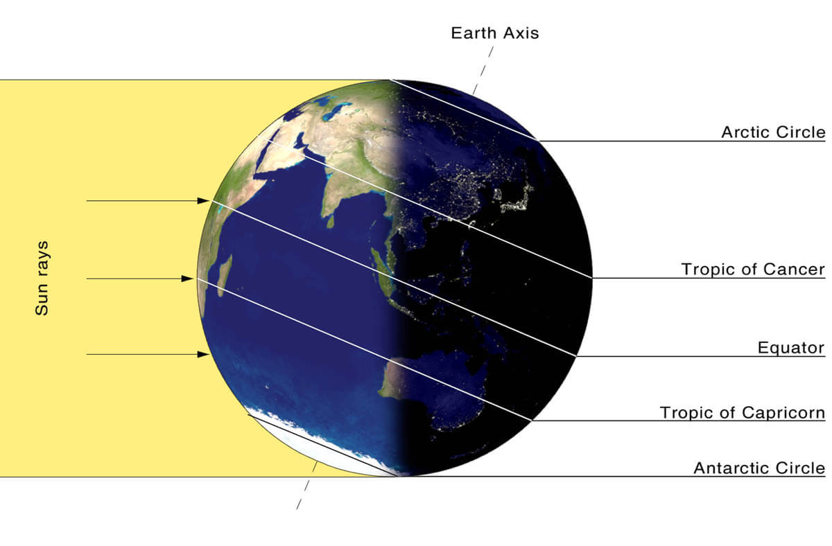
If we imagine how the Earth’s atmosphere is built, we have six layers that are rounding our planet. And most of the weather that is affecting our lives occurs in the lowest two layers, we know them as the troposphere and the stratosphere.
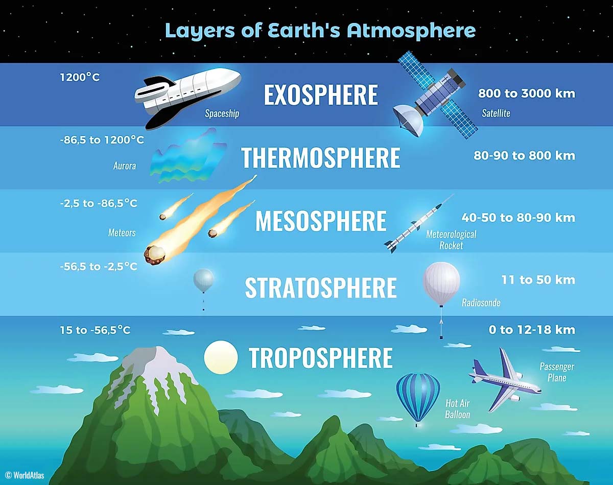
The lowest is the troposphere and is sitting on the Earth’s surface, this is where all the weather changes we encounter take place. The troposphere layer is about 12 km thick and is extending from the surface up in the sky. Although its depth actually varies between 8 km to almost 20 km, depending on where you live. It is the deepest above the equatorial region, and it gets much thicker above the North and South poles.
Right above our troposphere, there is a much deeper one, known as the stratosphere layer. The stratosphere is about 10-50 km thick and the air in it is also very dry. This layer also contains the well-known Ozone layer, the one that has a vital role in the protection of our planet’s life against the storms from the Sun.

There is one important part of the stratosphere that triggers all the weather dynamics, that is the Polar Vortex. It is an enormous, 3D ring of very intense winds grazing the sky high above our heads. Polar Vortex surrounds both the North and South poles, moving through the air at about 20-50 km above the Earth’s surface.
Both layers, the troposphere, and the stratosphere are particularly crucial for the climate we live in, as the Polar Vortex actually covers most of the bottom half of our atmosphere. As it extends from the middle of Earth’s troposphere up into the stratosphere layer, it has the main effect on the winter weather across the high and mid-latitudes as we could see across North America, Europe, and Asia, and indeed the Pacific and Atlantic oceans.
The Polar Vortex is always the strongest during the winter months in both the Northern and the Southern hemispheres.
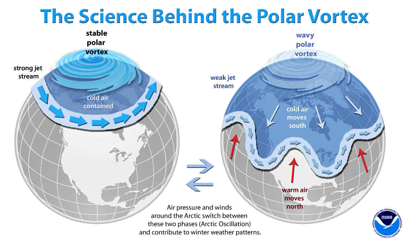
Although the Polar Vortex spins far above our heads, it remains directly connected to the lower part of the atmosphere. Thus, it gives our daily weather a shape in many ways, as it works as one large hemispheric circulation. All the dynamic systems we have seen this winter have been triggered with the activity of the Polar Vortex above.
How the Polar Vortex forms?
Every year as the calendar turns into autumn, the polar regions begin to receive much less sunlight. This way, the cooling over the north pole takes place and as a result, polar nights occur for several months, with days without any sunlight following.
But as the polar temperatures are dropping, the atmosphere layers farther south are still relatively warm as they continue to receive more energy from the Sun. So those layers towards the equatorial regions to the south are still much warmer compared to the areas farther north. A high-temperature contrast develops between them.
The other effect of the poles getting cooler also translates into lowering the ambient surface pressure. And a pretty similar weather process also happens in the stratosphere layer above it, so the temperature difference between the North pole and the equatorial areas increases. It generates a large low-pressure cyclonic circulation across the polar stratosphere. This is why we call this feature the Polar Vortex.

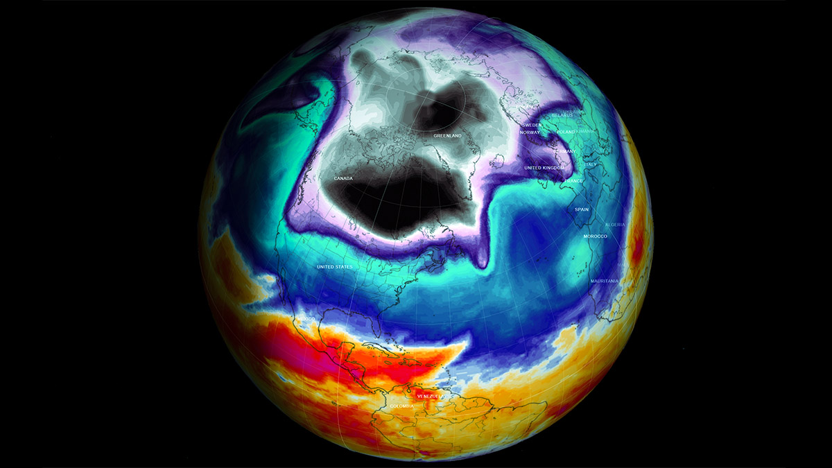
Putting all these pieces together, the Polar Vortex is actually acting as a very large and deep cyclone in the atmosphere. It covers the whole North Pole, extending far south to the regions in the mid-latitudes. It is of course the same also in the southern hemisphere during their winter. The chart above hints at a very typical example of the Polar Vortex set above us. The image represents the pressure at around 30 km (18 miles) altitude which is near the top of the stratosphere layer during the winter season.
As said earlier, the unusually active Polar Vortex in Winter season 2021/22 is the main trigger behind all these recent winter storms and cold outbreaks across Canada and the U.S. this week. It will be once again a repeat of the previous systems, a huge severe weather impact for millions across the United States as deep trough develops into western and central portions of the US.

The combination of fresh Arctic cold air under the lobe of the Polar Vortex against the warmer and moist air from the south leads to dangerous winter storm formation. It will once again bring a lot of snow for some, freezing rain, and also severe weather with tornadoes for the South.
THE INTENSE POLAR VORTEX OF 2022
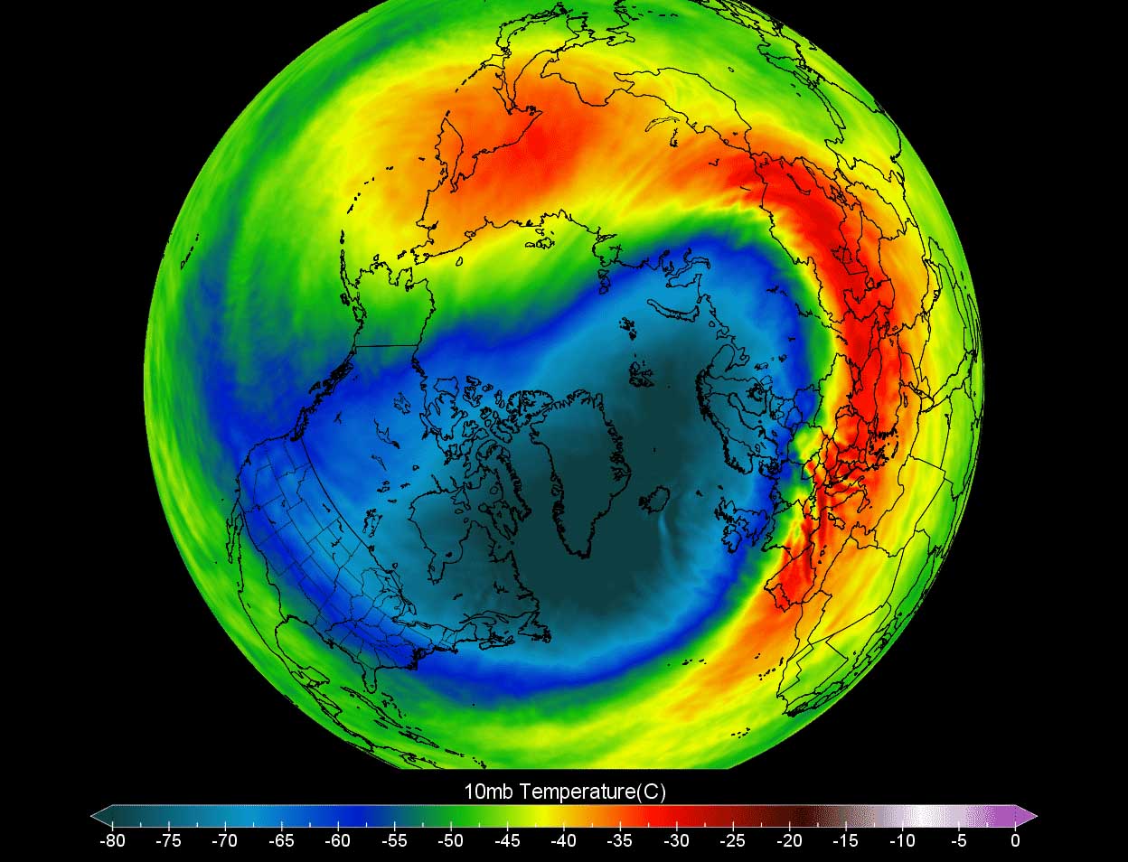
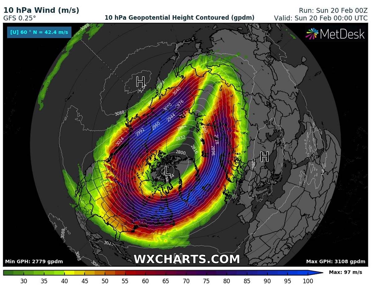
When we monitor the intensity of the Polar Vortex, we usually look at the temperatures and their anomalies at the 10 hPa pressure level aloft. That’s the stratosphere layer we discussed above, at near 30 km elevation. The vortex this month has been very intense and cold, as we can see from the chart below. The most intense part (southern lobe) sits right above North America.

Temperatures are there from -70 to -80 °C, which is extremely cold even for these levels. While it is so cold over U.S. and Canada, the temperatures are warmer over the other parts of the Polar Vortex.
So these temperatures are actually nearly 30 °C below normal at this level above. And this is the reason why these events this winter are so particularly intense and also occur quite frequently over this part of the Northern Hemisphere.
Notice the temperatures of the other side of the vortex, above Europe and Asia, are much warmer. About 10-15 °C above normal for this time.
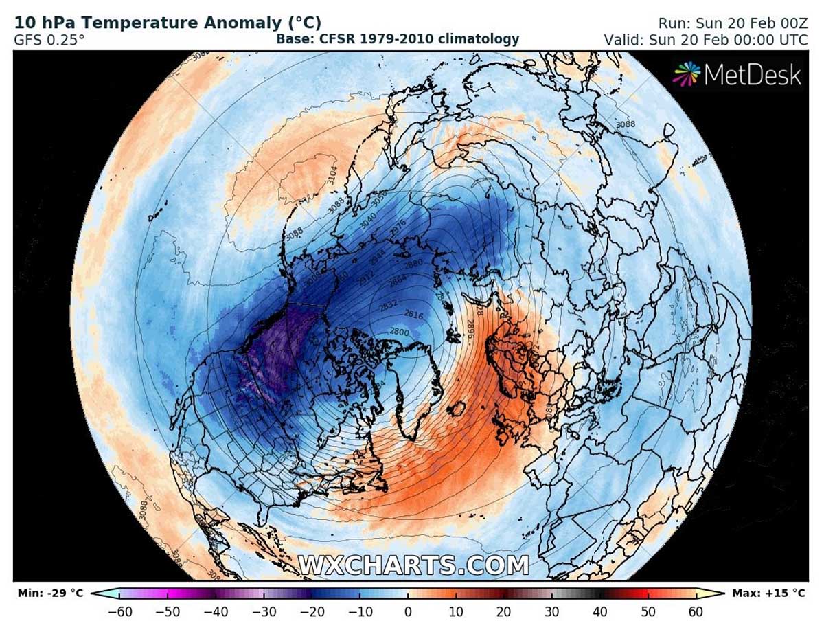
As normally, the temperature difference between air masses has a direct response to winds. Thus, the intensity of the Polar Vortex circulation is much stronger when the temperatures are so far apart. It currently spins with 200-220 mph up there.
We would expect the Polar Vortex to finally wind down and begin weakening as the Winter season is coming to an end, but this year’s it is just not giving up yet. However, the recent model trend does hint at its final weakening as more significant warming is seen in the eastern parts. This should gradually end this few-week period of wild winter weather.
WINTER STORM NANCY AND OAKLEE BRING NEARLY 50 °F TEMPERATURE CHANGE ACROSS THE CENTRAL GREAT PLAINS
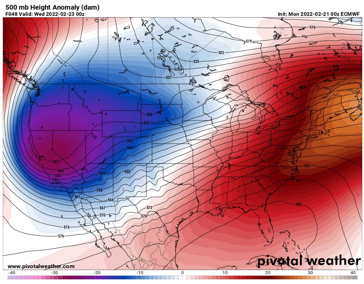
A textbook dipole weather pattern will again establish across the United States this week, with a very deep upper trough across the West and a strong, upper High for the East parts of CONUS. In between these large-scale features, two frontal systems, a Winter Storm Nancy and Oaklee, will bring wintery weather and a push of a massive, Arctic cold air far towards the south.
Normally, high surface pressure develops beneath a strong blocking High and cold aloft, thus it will cover much of Canada and the northern United States. With the first storm Nancy, the high-pressure builds upon the southward surging Arctic air through early days this week, feeding the system from the north.
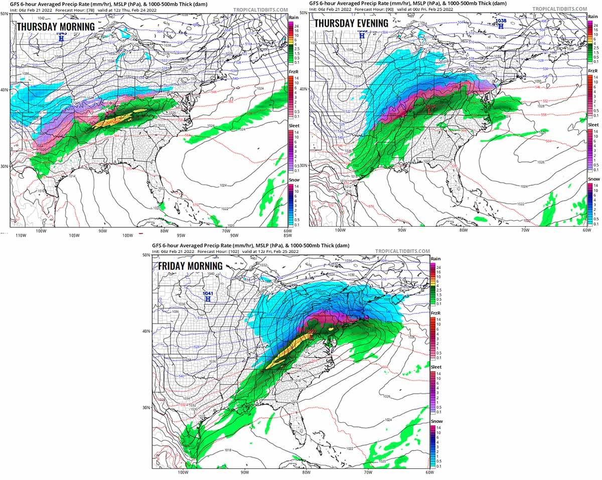
The following two charts below hint at these storms this week, both acting in a similar manner against the high pressure to the north. With the trough sitting on the West, they will both move generally east-northeast across the U.S. Storm Nancy from Monday into Tuesday and Oaklee from Wednesday night through Friday.

The enhanced winds ahead of Nancy will lead to a massive transport of much warmer air from the Gulf of Mexico into the southern States, thus forming an unstable environment ahead of the moving frontal system. In its wake, a lot of frigid cold air will follow. With the pure meridional flow established, the general winds will be coming from the north-northwest and make the cold even worse. Thanks to extremely low wind chill temperature.
This Monday’s maximum temperatures were in the mid to upper 70s across the central Plains, with the significant cold still holding only over the northern states. It is even warmer in Texas, in the low 80s this Monday. But things will change particularly significantly tonight.
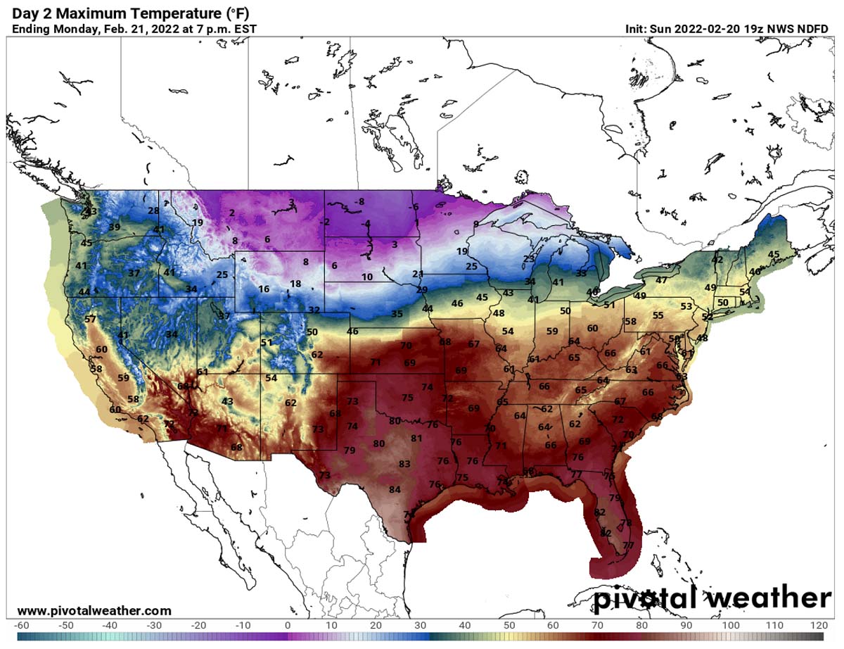
With the arrival of the Arctic cold on Tuesday morning, temperatures will surge nearly 50 °F lower than they are experienced this Monday. With the help of strong winds and windchills, it will be bitterly cold. A huge temperature drop in just less than 24 hours. The significant cold will extend in the coming days, and gradually intensify as even lower temperatures will follow.
Temperatures on Wednesday morning should already be in the mid-20s across central and north Texas, with Oklahoma in the 10s. Temperatures into single digits across Kansas, and indeed well below zero °F farther north. The deep freeze returns this week for many. Temperatures will be from -10 to -20 °F across Dakotas and High Plains on Wednesday morning.
With the northerly states experiencing some really cold days this week. The core of the extreme cold pool will spread across Wyoming, Montana, parts of Nebraska, and Minnesota, across both Dakotas and into southern Canada. With temperatures being 30 to 50 °F below normal for the end of February.
While the cold also gradually spreads south behind winter storm Nancy on Wednesday, being 20-30 °F below average from north Texas to Oklahoma, Kansas, and Iowa. The warmth will, however, stay across the deep South and be particularly high across the East Coast, the Mid-Atlantic, and Northeast U.S. through mid-week.

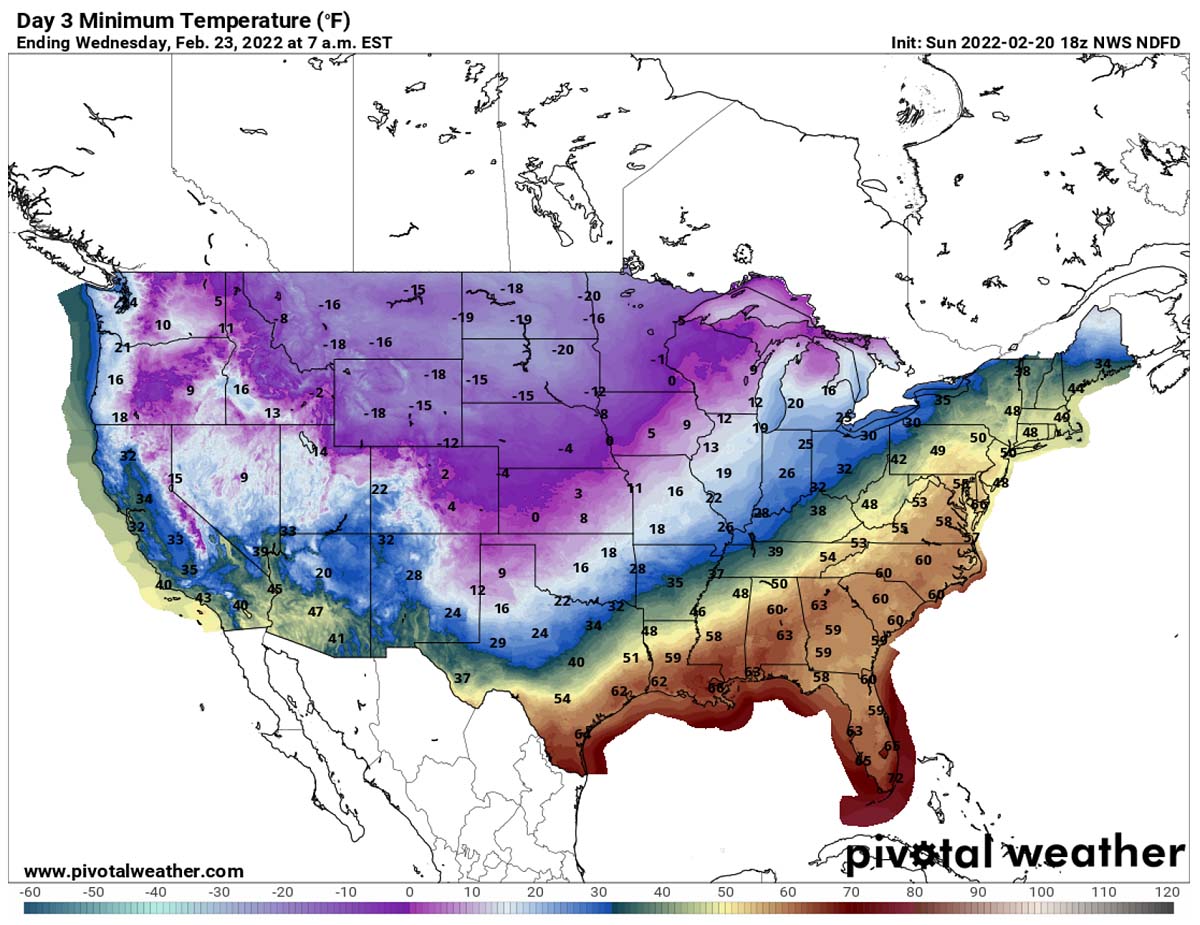
The arrival of the significant Arctic cold this far south will trigger another frontal system, which will be winter storm Oaklee on early Thursday. As it travels across the south-central portions of the U.S., it helps to drag the cold even deeper towards the south, reaching the Gulf Coast.
It will be very cold from Texas to the Mississippi coast on Friday, potentially nearly 25-30 °F below normal. While the next chart also hints at how a large part of the country will be influenced by this new Arctic blast. Only the far Southeast U.S. will see warmer weather, other areas will have temperatures well below-average.

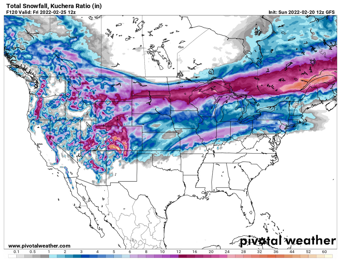
Both Nancy and Oaklee will bring snow, but mainly across the northern half of the country. As, despite the Arctic blast coming down so far south this time, all the moisture in front of the systems will already be pushed away before the cold meets it.
So the snow blanket will remain limited north of the line roughly from about Colorado and Kansas to Ohio Valley and Northeast US.
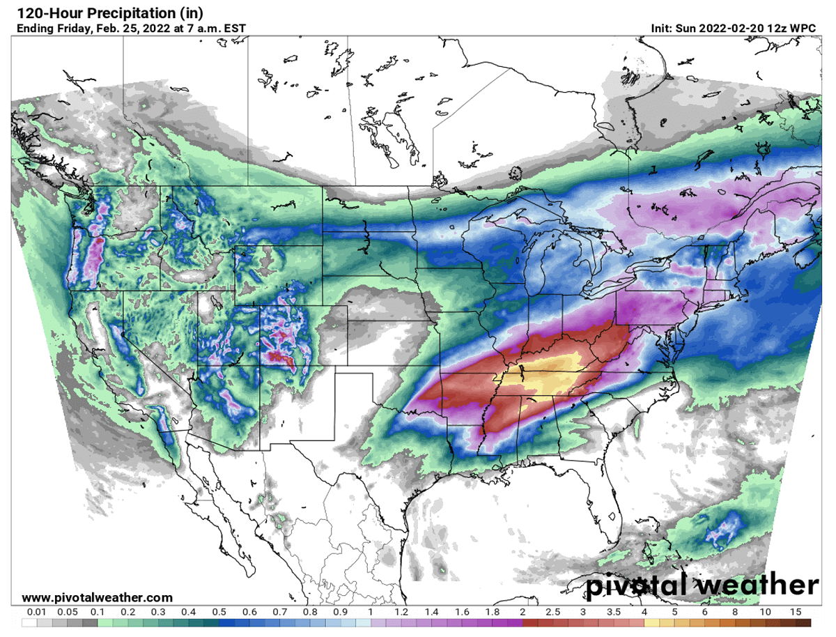
However, the advection of much warmer and moist air from the Gulf of Mexico will bring heavy rainfall for the Southeast states. Areas from the lower Mississippi Valley to the southern Ohio Valley should see a lot of rain, coming from both the frontal system and related convective storms, including severe.
The highest amounts of rain are forecast across Arkansas to Tennessee, Kentucky, and northern Alabama. Potentially between 4 to 8 inches is possible, leading to some local flooding in some areas.
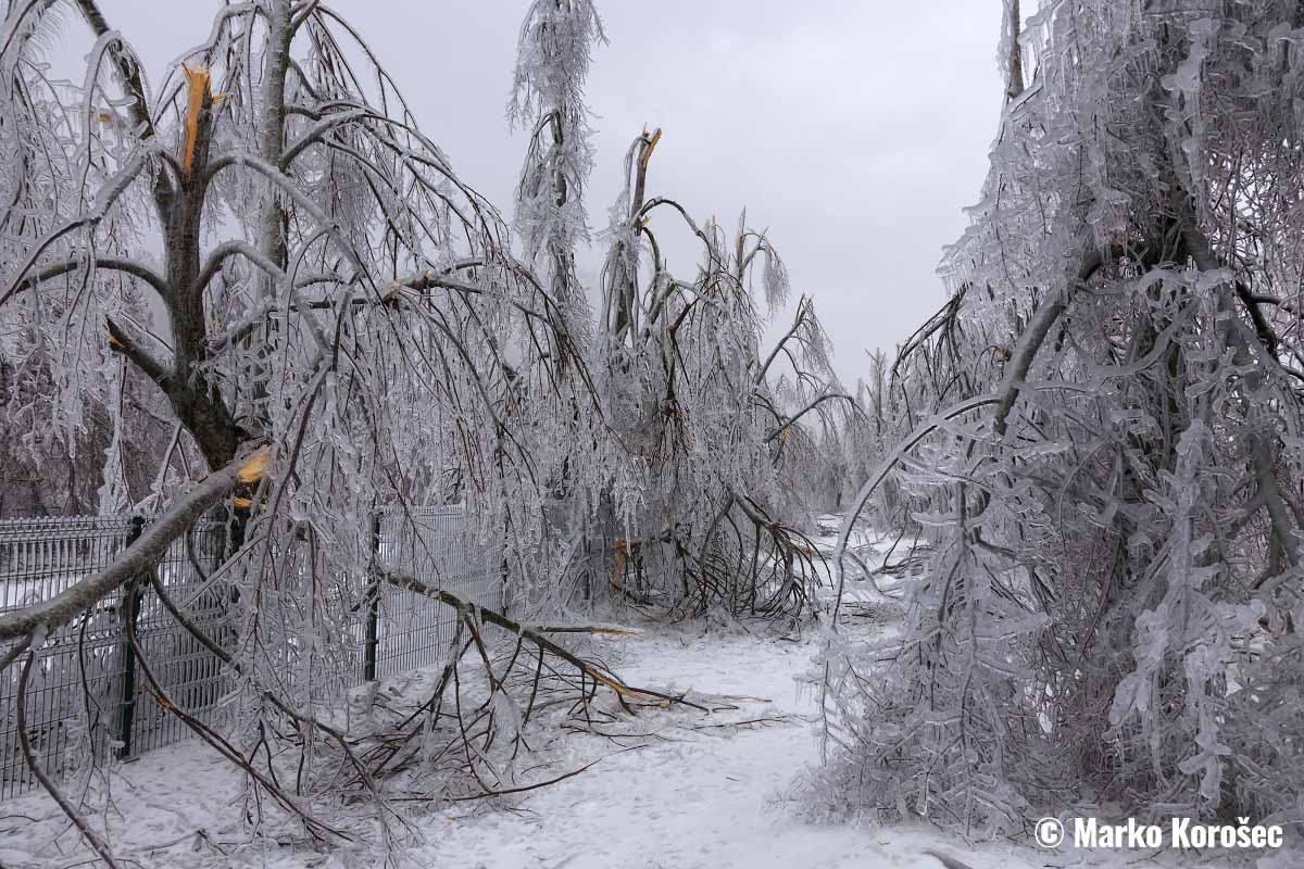
Nancy and Oakley might sound like normal winter storms, with snow to the north and rain to the sound. But unfortunately, they won’t be this easy handling frontal systems. A narrow corridor of particularly dangerous swath of icy weather conditions is insight as well. Odds for a damaging ice storm are increasing from mid-Mississippi to Ohio Valley on Thursday.
DANGEROUS FREEZING RAIN AND ICE WITH STORM OAKLEE LIKELY ACROSS CENTRAL STATES ON THURSDAY
With the new deep pocket of Arctic air mass to the south, a winter storm Oaklee develops across the southern Plains and moves farther east into the Mississippi Valley on Thursday. This will cause precipitation to increase, with heavy snow to the north of the frontal zone and rain with storms to the south.
But this middle part is something to have a close eye on, as a potential ice storm with a lot of freezing rain is forecast. There is an increased chance that a significant amount of icy conditions will develop from northern Arkansas and southern Missouri across the Ohio Valley towards New York state into Thursday night.
Freezing rain occurs when there is a layer of very warm air placed above a layer of below-freezing or subfreezing air near the surface. This means we have a thermal inversion with the temperature becoming warmer the higher we go. The falling snowflakes towards the ground begin melting in this layer as they continue to fall through the warm air.
At the time they are completely melted inside this layer, all the precipitation is falling as rain. But those layers near the ground have much colder temperatures since we have a thermal inversion in place. So, the liquid droplets freeze when they fall down and make a contact with exposed surfaces, forming a black ice thickness.

On some occasions, sleet forms. This is when the rain droplets freeze back to small iceballs before they reach the ground. And these ice pellets are a form of precipitation consisting of small, translucent balls of ice. They are much smaller than hailstones and are also different from graupel, which we can experience with snow and winter showers sometimes. Ice pellets are normally bouncing off the objects (like jackets, windshields, and dried leaves) when they hit the ground.
In addition, as sleet is made of a compact structure, it normally doesn’t freeze into a solid mass on the ground as freezing rain down. Unless it is coming down as a mix with freezing rain. This only occurs when heavier precipitation is present during an ice storm.
So the areas from the southern Plains across the Mississippi Valley to Ohio Valley and nearly up to the coast of New England are again in the particularly dangerous threat of an ice storm from Thursday through Friday morning.
What appears increasingly likely based on the weather model forecasts recently is that the swath of the freezing rain potential is pretty large and the amounts could be very thick in some areas. The swath is placed roughly along the southern fringe of the southward surging Arctic cold pool. The forecast amounts of ice accumulations are concerning in some areas, which could lead to catastrophic tree and power lines damage.
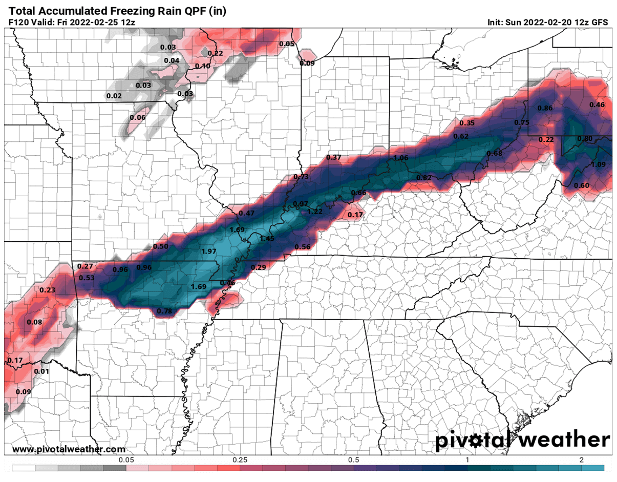
The amount of freezing rain forecast and ice thickness accumulation is very significant. Even more than 2 inches (5 cm) of ice could accumulate in some areas and that would undoubtedly lead to significant tree damage and power outages. Power lines are in great danger when tree branches are crashing down onto them with the large weight of ice.
The accumulating ice weight becomes well off the powerlines limits when the ice thickness is more than 1 in (~2.5 cm).
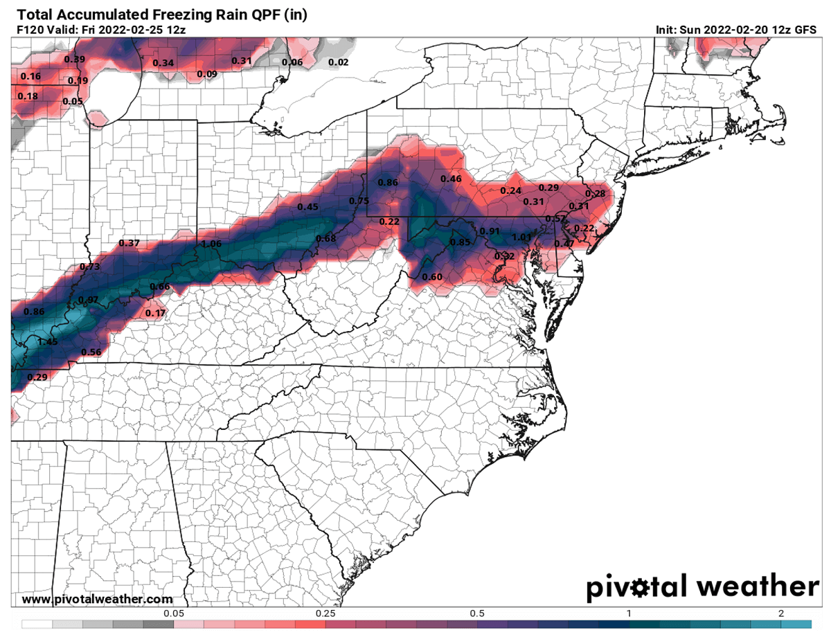
Freezing rain should also extend towards the northern portions of the Mid-Atlantic region into Friday morning, although the amounts are forecast to be less significant here. Nevertheless, more than 2 inches of black ice thickness would be catastrophic for the trees and powerlines in those areas affected on Thursday.
The black ice is a term we use when the ice has accumulated on the surface of a roadway. It is purely transparent but takes on the color of the surface of the road it is on, becoming invisible and thus very dangerous. Once the ice gets wet from the outside temperatures finally warming up, black ice becomes even more dangerously slick. This is the perfect recipe for when we hear about the huge pile-ups of deadly road accidents around the world in the past.

Ground travels will become very difficult as ice thickness grows, and even worsening when it gets covered with fresh snow once the colder air mixes down from the north towards Friday morning. This combination of black ice and snow atop of it is usually the most dangerous scenario for road accidents in winter.
MORE SEVERE WEATHER WITH TORNADO POTENTIAL FOR THE SOUTHERN STATES
With the strengthening of the frontal system and winds across the south, severe thunderstorms will be possible from Monday evening into early Tuesday. The potent wave moving across parts of the southern Plains, Ozarks, and lower to mid-Mississippi Valley. The threat may bring hail, damaging wind gusts, and a couple of tornadoes possible as well.
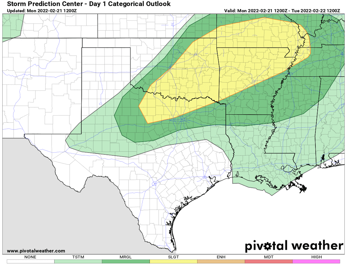
Intensifying winds will push deep, moist tropical air from the Gulf of Mexico into portions of the southern United States from today through Wednesday which will serve as the fuel for potential severe damaging storms. Those could be quite intense from parts of Texas and Oklahoma, east to Mississippi and Tennessee from tonight into Tuesday.
The severe weather threat continues on Tuesday, with severe thunderstorms associated with an isolated tornado threat, wind damage, and large hail possible from Tuesday afternoon and evening from parts of the lower to mid-Mississippi Valley and Central Gulf Coast into the Ohio and Tennessee Valleys.
The overall thermodynamic and wind profiles should be favorable for the development of supercell storms with primary wind and isolated large hail damage. A tornado threat is also expected to develop as the low-level winds increase through the late afternoon and early Tuesday evening.
The potential for a couple of tornadoes is expected to increase from southeast Missouri into the lower Ohio Valley during the day on Tuesday, and then expand southward across the Tennessee Valley and into the northern Mississippi and Alabama by late afternoon and early evening.
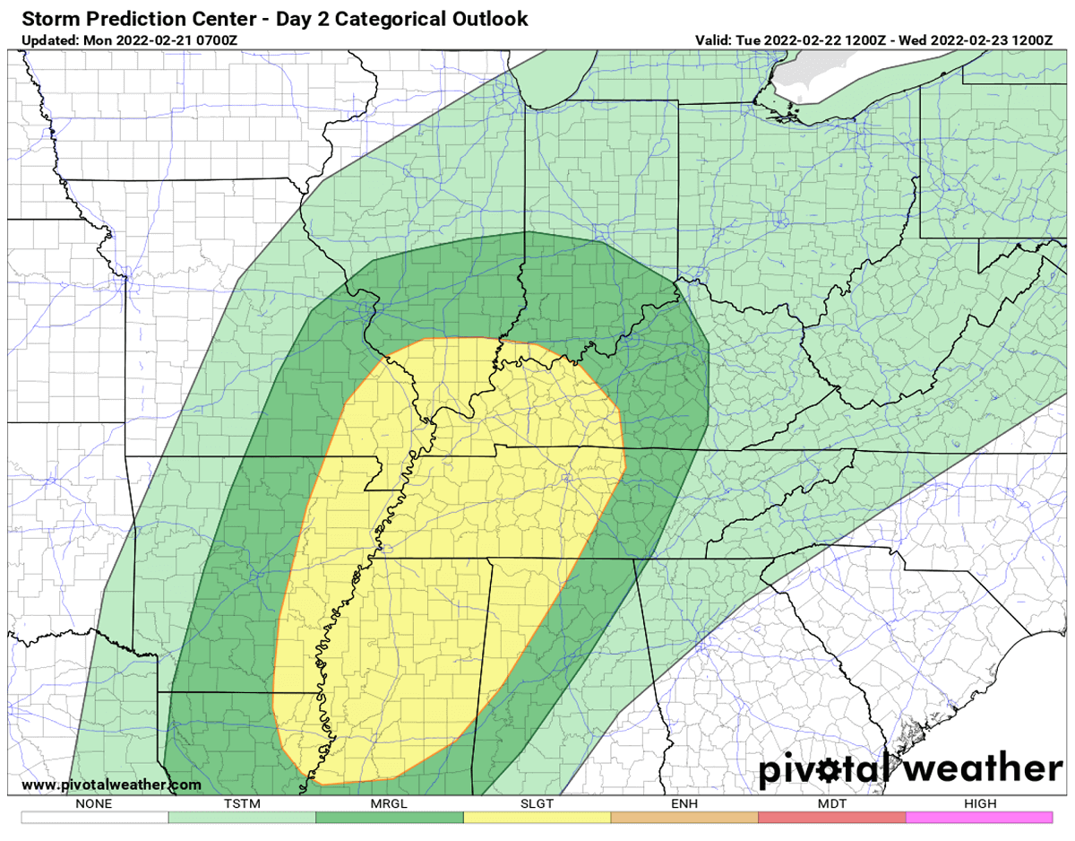
Additional severe storms are also possible with Winter Storm Oaklee on Thursday, especially across the Southeast U.S. Stay alert!
Images used in this article were provided by Windy, TropicalTidbits, and Pivotalweathers.