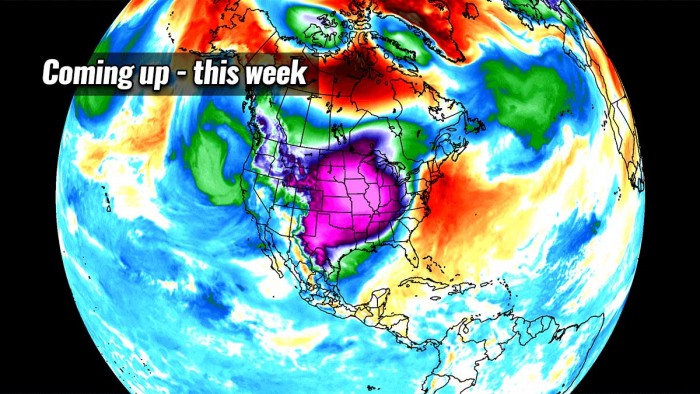
February, the final winter month, is about to set the grand finale to the meteorological winter 2020/21 across southern Canada and the United States. The deep freeze is underway and will just be getting worse, as the Arctic blast strengthens into one of the most intense in years this coming week. Its southward progress coincides with a break-off lobe of the Polar Vortex aloft.
If you thought the weather was not that cold so far, wait before you sign off this winter.
The weather pattern across the North American continent is setting up an impressive prolonged period of a deep freeze, with life-threatening wind chills across southern Canada and the northern United States this week. The very cold temperatures arriving will be the lowest this winter so far, and actually, the cold blast itself will be one of the coldest in the past years.
It is also very cold in parts of Europe, as strong outbreak of very cold air is underway: Cold wave under the break-off lobe of Polar Vortex heads further south across Europe, bring more snow into parts of the continent this week.
It may have been a slow start to the winter this season, but the final winter month returns with THE Arctic blast. We could say a grand finale. The temperatures across the Midwest and parts of the Plains have lately been higher, although still quite cold, but you might be missing these very soon.
A *frigid* cold with windchills near -50 °F is coming up this week, one of the most intense in years for the northern tier of the States. And not for a day or two, those will last for almost a full week!
Here is a video animation of the temperature (and anomalies) evolution across the lowest levels of the atmosphere over the next 10 days. Notice how far south the cold expands, reaching the Gulf and even Mexico late this week.
This Sunday morning, the southern fringe of a newly developing Arctic blast was spreading south, at the same time as the Polar Vortex lobe aloft is also expanding south towards the US. Temperatures across North Dakota, Minnesota, and Wisconsin reached 20 to almost 30 degrees below zero.
Together with moderate northerly winds from Canada, the windchill temperatures have helped the real feel to be even colder. A life-threatening -45 to -50 °F windchill was experienced across northern Minnesota. North Dakota, Wisconsin, and the rest of Minnesota were not far behind either, -35 do -40 °F was reported there as well.
But now, thanks to the further progress of the cold blast, things are getting much worse. With a prolonged dangerous cold and windchills towards the Great Plains and the Midwest developing this week. Highs will remain deep below zero F for days, with bitterly cold Lows, dangerous for frostbite. Thanks to the breezy winds.
BREAK-OFF LOBE of POLAR VORTEX SHIFTS SOUTH, WINTER WORSENS
The winter weather so far has shown strong pattern dynamics. It has been going wild across the North American continent for weeks. Thanks to the Polar Vortex collapse in early January. The dominant feature for weather development afterward was the high-pressure over the Arctic region, being the most pronounced over Greenland.
Before the collapse, the first month of winter (December) was relatively calm and even milder than normal across North America. And it also continued into January, as the most significant effects of the Polar Vortex disruptions normally take a few weeks. Most of the continent was warmer than normal, especially across eastern Canada being under the high-pressure system.
The stratospheric warming wave has moved across the entire North Pole in the stratosphere, effectively splitting the cold-core of the Polar Vortex into two parts.
One part of the broken polar vortex was pushed over to North America and one over the European side. At first, this did not have much to do directly with the winter weather near the surface, as this is at 30km altitude. But as we are see on the latest model guidance, our weather gets its share from this battle this week.
Further south, there were a number of major winter storms across the country, dumping a lot of snow, ice, and blizzard conditions across the Great Plains, Midwest, and across the Great Lakes into the Northeast/Mid-Atlantic regions. Near-normal to slightly colder temperatures were observed.
Lately, the Arctic blocking High moved further towards the polar circle lately, turning the very cold weather deeper towards the south across into North America. The coldest air yet of the winter season is on its way south from Canada, as the Polar Vortex leaves its home in the Arctic circle and pay to visit the US and Canada through mid-February.
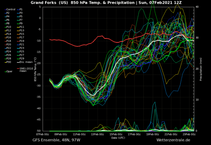
As seen on Sunday’s report above, the northern tier of the country has already been brought into a deep freeze. Below is the meteogram chart for the city of Grand Forks, North Dakota over the next 14 days. The long-term normal at 850 mbar level (approx. 1300-1400 meters above sea level) is around 14F (-10 °C) through mid-February. Temperatures are now around -15F (-26 °C) but they will push down to -31F (-35 °C) by Friday. That’s nearly 50 °F below normal!
Before the cold spreads farther south, yet another major snowstorm is traveling across the Northeast, just a few days after the greatest snowfall in years hit the Mid-Atlantic Region.
The progress of the Arctic air mass coincides with a break-off lobe of the Polar Vortex aloft, moving towards southern Canada and the United States in the coming days. It will introduce extremely cold winter weather into much of the north-central parts of the country and start a prolonged period of deep freeze coming up this week.
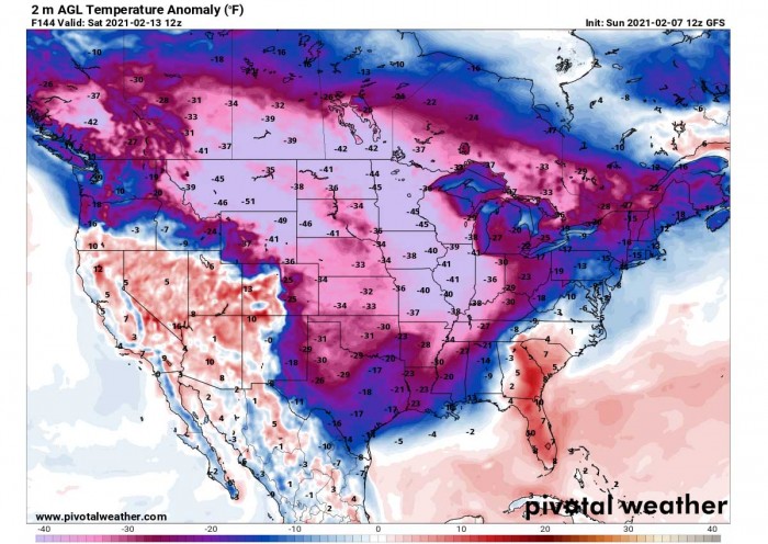
If we look closely at the surface temperature anomalies, this southward turn of the polar vortex will bring frigid cold temperatures across the Great Plains and the Midwest. Therefore, a typical ‘deep freeze’ situation is now unfolding.
Surface temperatures will drop between 30 to 50 degrees Fahrenheit below the normal values for mid-February. The actual temperatures will push down to the -30 °F range across much of the north-central and the northern parts of the US.
Thanks to the disturbed flow after the Polar Vortex changes, the weather patterns this time are not of a short breath. The extreme cold will extend also past mid-February. The high-pressure system will remain a dominant mesoscale feature, centered over the Greenland peninsula. So it will favor lower pressure over western Canada and the northern United States. Much below-normal temperatures will reach the Gulf and Mexico next weekend as well.
So the intense Arctic air outbreak and deep freeze will persist across the North American continent, with much of southern Canada and the United States experiencing the lowest temperatures of the winter season 2020/21. The cold pool will be very large, expanded across much of the country with barely any significant weakening until at least around February 20th.
LIFE-THREATENING WINDCHILLS THIS WEEK
Almost a week-long period of extremely cold weather and breezy winds will push the temperatures very low. Actually, some of the coldest weather periods with *very* low temperatures are likely through mid-February. Surface temperatures are expected to drop 40 to 50 degrees F below the long term average for this time of the year, extending from the northwestern United States into the central parts of the country.
The 2m temperature forecast below hints at the surface temperatures in the negative values covering a large part of the country, with single-digit temperatures covering over a third of the country. Except across the far southeast parts of the US.
Such cold air will result in life-threatening for those caught outside for an extended period of time. Frostbite will be the highest danger as these temperatures will be combined with strong winds. Hypothermia (a medical emergency that occurs when your body loses heat faster than it can produce heat, causing a dangerously low body temperature) can become a serious threat.
It is important to use several layers of protective clothing to avoid these cold-weather threats. The extreme cold of this magnitude can also freeze the water pipes, if not properly protected.
MORE DEEP SNOW FOR MIDWEST AND NORTHEAST
Normally, these cold blast events also mean an increased chance for snowfall. Weather model guidance over the next 10 days is quite generous with the snow depth increase across the United States, with a swath of winter storms traveling from the northern Rockies across the Midwest to the East Coast and the Northeast through mid-February.
A significant snow depth increase is forecast across the northern half of the country, from the northern Rockies across the central Plains, Midwest, Ohio Valley, and further east into the Mid-Atlantic and the East Coast. Eastern Canada and New England will also see a significant snow depth increase over the next 10 days.
One winter storm is ongoing across the Northeast this Sunday. The next one brings some accumulating snow across the Midwest and towards the East Coast on Monday into Tuesday. Dumping even more snow across the Northeast.
Basically, the broad swath from the northern Rockies across the central parts of the country to the East Coast will see occasional snow into the mid-week. More snow is likely towards the weekend along this stretch.
So wintry weather conditions will make your week quite busy. If you plan to work outside, be prepared. Thanks to the combination of extreme cold, breezy windchills, snowfall and locally blowing snow, things might get really bad at times. Surely a period to remember this winter.
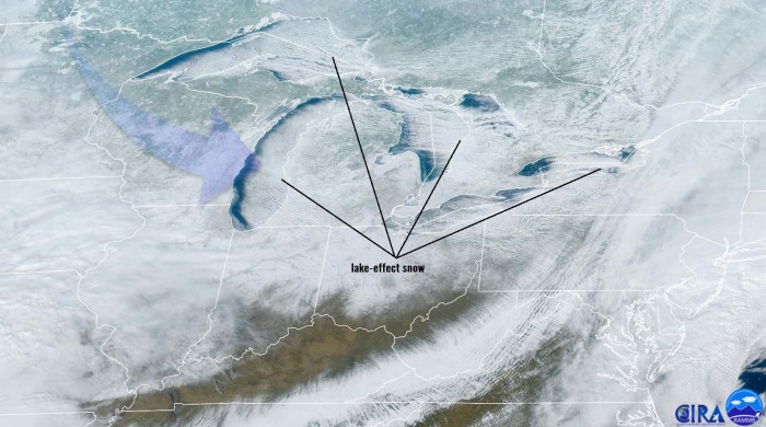
Due to the prevailing west-northwesterly winds across the Great Lakes, heavy lake-effect snowfall will also develop in the coming days. Until the below-average ice coverage is there, warmer lakes will produce snow on the east and southeast adjacent shores of the lakes. But the much colder air will gradually freeze the lakes and increase the ice coverage this week.
What’s next until the end of February? See below:
***The images used in this article were provided by Windy, Wetterzentrale, PivotalWeather, and NOAA.


