February, the final winter month, has now set the grand finale to the meteorological winter 2020/21 across southern Canada and the United States. Extremely low temperatures and winds brought life-threatening wind chills even lower than 50 below across the north. The Arctic blast with deep freeze continues south and is expected to peak around Valentine’s day, thanks to the further southward progress of the break-off lobe of the Polar Vortex aloft.
Those normal cold days and snow last week weren’t that bad, huh? Exactly. You might not need to think of that gentle cold twice after walking outside right now. If you thought the weather was not that cold so far, you now surely know what the real cold is. Temps are frigid in many areas.
While some were almost signing off the winter after the effects of the Polar Vortex collapse aloft have had some delay lately. It was a cold pattern, but not too significant. The change this week came with a bang, that’s for sure. Extreme cold spread from Canada into the northern half of the United States with temperatures pushed to near 30 below.
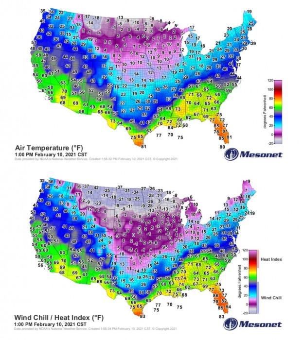
Thanks to the northerly winds, the real feel was even worse. Life-threatening wind chills of below -50 °F impacted North Dakota and Minnesota on Monday and Tuesday. These frigid cold temperatures are gradually spreading further south now.
Extreme cold with deep freeze has spread across a large part of Canada and the United States this week, and you might think this is it? Wait, there is more coming up. The forecast cold is so intense that weather models are maxed out their temperature anomaly scales around Valentine’s Day. This will be a historic cold for many areas, with many temperature records to be broken.
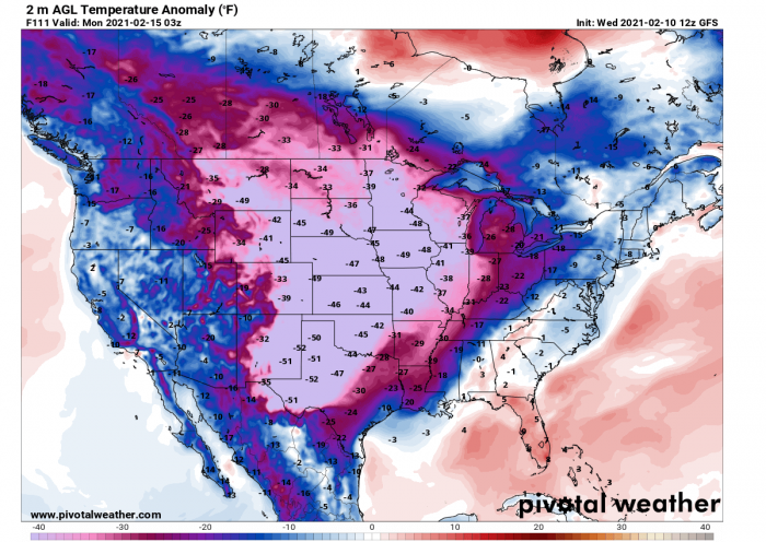
The consensus of the various weather models is actually very good, all are hinting even stronger Arctic cold to develop and spread far south towards Texas and New Mexico over the weekend. Temperatures will likely plummet into deep freeze there as well, being more than 50 degrees F lower than normal for mid-February. And indeed maintain further north the central parts of the country, also into Canada.
The weather pattern across the North American continent has set up an impressive prolonged period of a deep freeze, with life-threatening wind chills across southern Canada and the northern United States. Those should also extend into next week. The very cold temperatures have, so far, already set some near-record daily values across the north.
And the cold forecast over the coming Valentine’s Day weekend should bring not just the lowest this winter so far, but a historic cold for many areas across the south. We could call this one THE Arctic Blast, with the big ‘B’. The cold blast itself will result in one of the coldest events in the past years, especially for the usually warmer deep South.
By mid this week, the southern fringe of this widespread Arctic outbreak has already dig as far south as central Texas and Mid-Mississippi Valley, at the same time as the Polar Vortex lobe aloft is also expanding south from Canada.
Temperatures across Montana, North Dakota, Minnesota, Wisconsin, and Upper Michigan are in the deep freeze, the Highs are 5 to 10 degrees below zero F. And below freezing down to west Texas, Oklahoma to southern portions of the Midwest and Ohio Valley to the Northeast US.
The northerly winds keep the real feel of the temperature much colder, the windchills are staying even below -30 °F. Windchills below zero are spread across the central Plains, roughly from northeast Colorado to southern Kansas and central Illinois northward. That’s a very low temperature if you remember these are peak daytime hours, so the morning windchills are being pushed even lower, to 45 to 55 below in the northern states.
And this is not even the worst yet. According to the latest model guidance, the forecast cold for the coming days will introduce a very significant and locally dangerous extreme cold, especially for the southern portions of the United States over the weekend into early days next week. Daily record low-temperature records could be shattered in many areas.
A prolonged period of a life-threatening cold and windchills will maintain over much of the north and central Plains, developing also southward towards the deep South (e.g. Texas) on Sunday, Valentine’s Day this year. An ideal recipe to cuddle and enjoy the hugs on this special day, right?
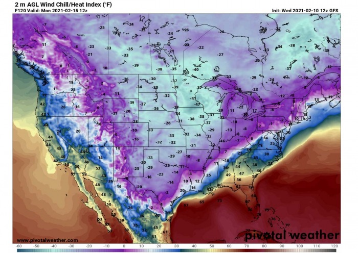
Giggles aside, the windchills could plunge even to 30 below across Kansas, Oklahoma, and Texas on Sunday and Monday. That’s *very* extreme and would be historic if the model charts are verified. Highs will remain deep below zero F for days, with bitterly cold Lows, dangerous for frostbite in minutes.
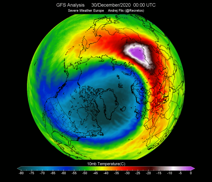
As mentioned earlier, the driver behind this historic cold across the US, or over the Atlantic the ongoing cold outbreak in Europe this week, is the Polar Vortex spinning above the North Pole. Some record-breaking events back and late December have strongly disturbed its circulation, lead to the collapse.
BLAME THE POLAR VORTEX COLLAPSE
As we have seen so far this winter, the weather has shown some strong pattern dynamics. It has been going pretty wild across the North American continent over the last weeks, basically from mid-January. Blame the Polar Vortex collapse in early January. Seriously. After the SSW event (Sudden-Stratospheric Warming) causing this collapse, the dominant feature for weather development was the high-pressure system over the Arctic region, being the strongest over Greenland.
Earlier, prior to the Polar Vortex collapse, December was relatively calm and even milder than normal across North America, especially over Canada. Such pattern also continued into the first half of January, as it normally takes a few weeks to show the effects of the Polar Vortex disruptions. Most of the continent was warmer than normal, being the warmest across eastern Canada under the high-pressure system from Greenland.
The stratospheric warming wave has moved across the entire North Pole in the stratosphere, effectively splitting the cold-core of the Polar Vortex into two parts. One part of the broken Polar Vortex was pushed over North American and one part over the European side.
At first, this didn’t have any significant effects on the winter weather closer to the surface, but changes have gradually taken place. With time, the Arctic blocking High moved further towards the polar circle, turning the very cold pool deeper towards the south across into the North American continent.
The coldest air yet of the winter season is on its way south from Canada, as the Polar Vortex leaves its home in the Arctic circle and pay to visit the US and Canada through mid-February. Later this week and over the weekend, the overall weather pattern over Canada and the United States hint at strengthening of the blocking High towards the Arctic region and deepening of the waves and cold cores further south.
Simplified this means nothing else than worsening of the ongoing weather situation can be expected. The cold will be even more extreme, including the windchill. And will be challenging temperature records.
POTENTIALLY RECORD-BREAKING COLD FOR THE DEEP SOUTH
The Arctic air mass currently spread over the north-central United States is not leaving anytime soon and is actually forecast to slowly expand east and especially south over the next few days. Daily high temperatures 20 to 40 degrees below average cover a widespread area from nearly the entire Great Plains to the Great Lakes.
By Friday, these cold temperatures could reach far south to the Gulf Coast and as far east as the Lower Mississippi Valley. Temperatures will
also make a plunge across the Northwest U.S., where daily records could be shattered as well.
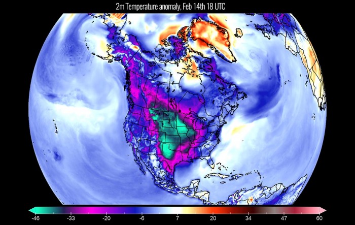
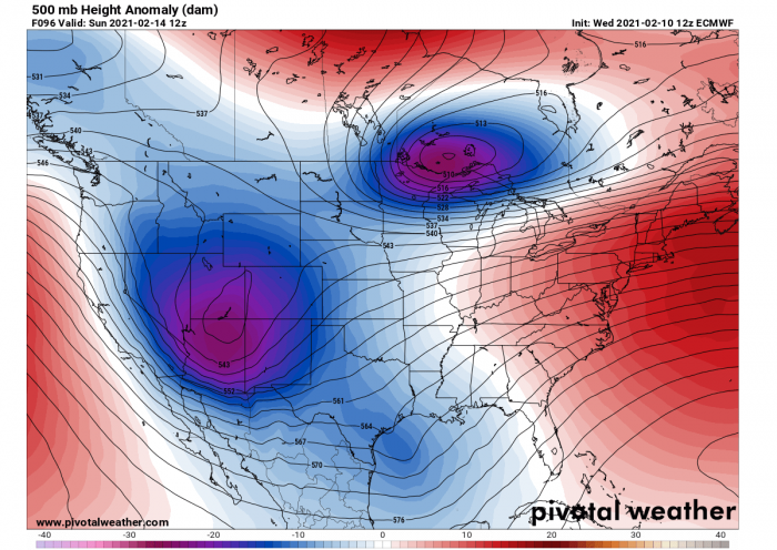
The progress of the Arctic air mass coincides with the southward tracking break-off lobe of the Polar Vortex aloft and keeps advecting extremely low temperatures from southern Canada into the United States in the coming days. What is also seen is the huge temperature anomaly that far south.
One would expect extremely cold winter weather to be confined more to the north-central parts of the country, but this time a prolonged period of deep freeze is also being spread into the deep South this coming weekend. And will likely extend into next week.
If we look closely at the surface temperature anomalies on the chart above, this southward turn of the Polar Vortex will bring frigid cold temperatures across the Great Plains and the Midwest. So the ongoing ‘deep freeze‘ will have no rush to finish anytime soon. It will remain frigid cold at least until Monday.
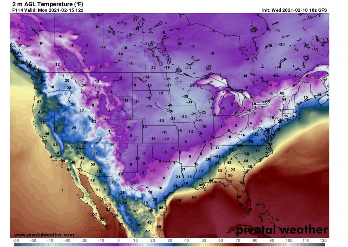
But the most impressive part of the chart is the exceptional temperature anomaly also forecast for the deep South. Take a look at the anomalies of more than 50 degrees below the long-term mid-February average. This means the forecast temperature of near 10 °F below zero (-12 °C) seems possible as far south as eastern New Mexico and West Texas.
There is no doubt, if these verify, this will be a record-breaking low-temperature event for the Southern Plains. And how ironic, right on Valentine’s Day this year.
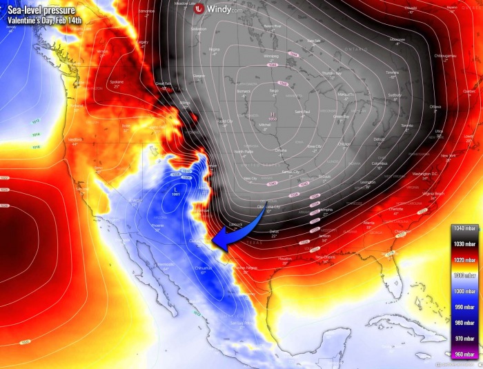
Wind chills will be even more frigid as strong winds are expected to result across the Southern Plains. Thanks to the strengthening High over the States and a surface low moving in from the west. High contrast in temperature and pressure develops. During the nighttime hours (e.f. Sunday and Monday Night), very low wind chill temperatures are expected.
Those could go as low as below -32 °F (-35 °C) on both nights. Imagine this is West Texas. Something you don’t see every day, not even every winter there. If any winter. It will be surely a must need to monitor the evolution of the outbreak over the next few days as some all-time low-temperature records will be challenged.
Such cold air will result in life-threatening for those caught outside for an extended period of time. Frostbite will be the highest danger as these temperatures will be combined with strong winds. Hypothermia (a medical emergency that occurs when your body loses heat faster than it can produce heat, causing a dangerously low body temperature) can become a serious threat.
Be sure to plan ahead and dress appropriately if spending time outdoors. It is important to use several layers of protective clothing to avoid these cold-weather threats. The extreme cold of this magnitude can also freeze the water pipes, if not properly protected.
NEARLY 50 DEGREES BELOW AVERAGE
Thanks to the disturbed flow after the Polar Vortex changes, the weather patterns this time are not of a short breath. The extreme cold will extend also past mid-February. The blocking upper High will remain a dominant mesoscale feature, centered over the Greenland peninsula.
As we have seen on Wednesday’s temperature analysis earlier above, the northern tier of the country has already under a deep freeze and very low temperatures. Those are staying far below. And part of this extreme cold air mass will also touch the deep south, including Texas, and near the Gulf Coast.
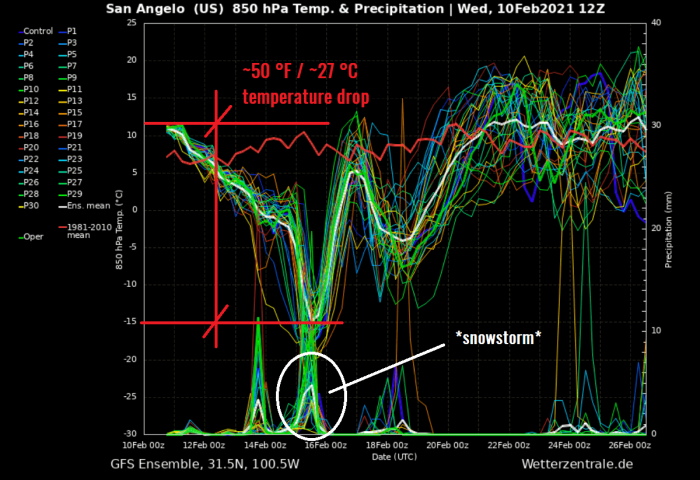
Attached below is the meteogram forecast chart for the city of San Angelo, Texas over the next 14 days. We can see that the long-term normal at 850 mbar level (approx. 1300-1400 meters above sea level) is around 45 °F (+7 °C) through mid-February. This Wednesday, the temperatures are around 54 °F (+12 °C) but they will push much much lower on Monday, Feb 16th.
Actually, those could be as low as around 5 °C (-15 °C) by Friday. That’s nearly 50 °F below normal! Although probably just for a short period of time, a significant drop is likely once the Arctic blast spreads that far south on Sunday.
Notice there is also quite some precipitation forecast on the bottom part of the chart, marked with a white circle. If we keep in mind the temperatures will be much below freezing, we know what this means – heavy snowfall potential.
MAJOR SNOWSTORM FOR THE SOUTH ON SUNDAY
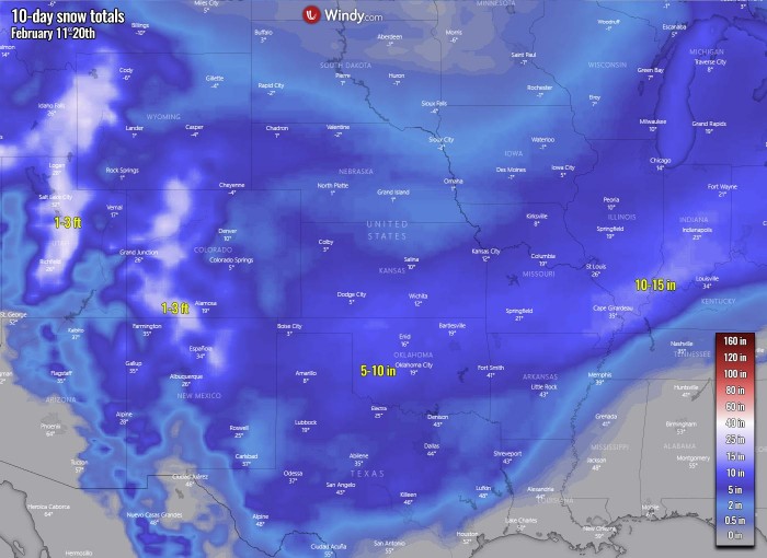
Besides the extreme cold pattern, another concern is the deep upper wave emerging across the southern Rockies on Sunday. What appears likely on the latest model guidance is the increasing potential for a major winter storm possible across the southern Plains on Valentine’s Day.
A significant amount of snow will be possible and could lead to travel disruption. As we can see from the pressure chart, the main issue with this snowstorm could develop a blizzard due to a very strong pressure gradient spread across the southern High Plains. Thanks to the very powerful near 1050 mbar high-pressure system dominating a large part of the United States and southern Canada.
This is indeed related to the deepest core of the break-off lobe which coincides with the Polar Vortex aloft. Notice there is a nearly 50 mbar difference forecast between South Dakota and southwestern Colorado, with very tight isobars (lines connecting the same pressure points) along the Rocky Mountains.
Parts of the Southern Plains could be impacted by a snowstorm on Sunday with possibly 5-10 inches of snow on Sunday into Monday across North Texas and Panhandles, Oklahoma, southern Kansas into Missouri. Even more, potentially close to 15 inches of snow could accumulate further east across Illinois and Indiana later on.
Strong winds will result in blowing snow, as well as heavy snow blizzard and also whiteout conditions. Roads could become impassable in some areas, also with the large snowdrifts possible to form. Surely be careful out there, the weather will be dangerous and quite far from the one romantic day you’d want to achieve this coming Sunday.
***The images used in this article were provided by Windy, Wetterzentrale, PivotalWeather, and WXCHARTS.
