The month of February, the final month of the meteorological winter, is making pay off with some robust, extreme cold, and snowy weather in the forecast lately. This seems like the grand finale of the winter season 2020/21 across a large part of the European continent. Thanks to the very cold period stretching from western to eastern Europe beneath the further southward progress of the break-off lobe of the Polar Vortex aloft.
The other side of the Polar Vortex is also sending a frigid cold across the United States, right for the Valentine’s Day this weekend.
Now, the deep freeze ongoing across parts of Benelux, Germany into Poland and the Baltic region is getting even stronger this week. While areas further south are still having mild conditions, the weather will be getting worse in the coming days.
A powerful Arctic blast intensifies across eastern into central Europe, bringing the extreme cold with low wind chills into the Balkans, the Mediterranean, and Turkey through mid-February.
It surely has been a rather mild pattern lately, and many have already signed off the winter. If you just gave up last week, the weather change has just tricked you. A belt of very cold weather has advected from the Baltic region all the way west to England, and blanket many regions with significant snow cover.
The weather pattern across the European continent is now setting up an impressive prolonged period of severe cold with low windchills across parts of central and eastern Europe, also farther south towards the eastern Mediterranean. The freezing temperatures spread across parts of central Europe and the ones expected over the Balkans will the one of the lowest this winter so far.
Attached below is a video animation of the temperature across the lowest levels of the atmosphere and precipitation state evolution across Europe over the next 5 days. The extreme cold expands south, reaching the Mediterranean, Greece, and Turkey by the weekend.
As we can see, the cold weather is now expected to extend towards the weekend and reach as far deep south as far as Libya and Egypt over the weekend. It will be very cold across the eastern half of Europe at least until the middle of next week.
FEBRUARY’s WINTER STRIKES
It may have been a slow start to the European winter this season, but now February, the final winter month, returns with the bang. Might be that grand finale with ‘all bets in’ one could say.
The temperatures across the southern portions of Europe were warm over the weekend and early this week, with many regions hitting 15 to 20 °C. Even spring-like weather of around 25 °C in Turkey this Tuesday! If you live in these areas and don’t like the cold weather, you will be missing these days very soon.
The current pattern evolving over Europe has brought a huge temperature contrast between southern and northern Europe, with a frontal zone in between. Several consecutive frontal systems brought heavy rains and local flooding in the south, with mild weather stretching from the Iberian peninsula across the Mediterranean to the Black Sea region.
Further north, it has been pretty wild weather with deep snow reported from eastern England across northern Benelux and Germany over the weekend into early days this week. The Netherlands and northwestern Germany, in particular, were severely hit by a massive snowstorm.
This was the first significant winter storm for the region in more than 10 years. Yes, this just shows you how rare their events have become over the last decade.
The system was named Darcy and significantly disrupted the transport and traffic between Netherlands and Germany on Monday, including the usually smooth rail connections. Some parts were badly hit with a huge amount of snow, combined with strong winds resulting in blowing snow.
There will be a couple of winter storms traveling from west to east over the next five days, with one system crossing the northern Mediterranean and the Balkans on Wednesday. This low will be strengthening while moving across eastern Europe, associated with a major snowstorm from central Balkans to Ukraine and Belarus on Thursday through Friday.
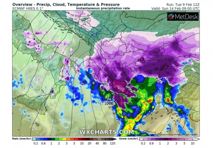
Another system emerges over Italy on Friday and brings stormy weather with also quite some snow across south-central Italy, and especially across the southern Balkans (Albania, Greece, Bulgaria, and Turkey) with a massive snowstorm and blizzard conditions over the weekend.
BREAK-OFF LOBE of POLAR VORTEX PUSHES THE COLD FAR SOUTH
The weather so far this winter has shown strong pattern dynamics, especially over the last few weeks with a continuous frontal system coming east from the Atlantic. This pattern has become more dynamic after the Polar Vortex collapse in early January. As actually quite typical, the dominant feature afterward was the high-pressure over the Arctic region, being the strongest over Greenland.
Before the Polar Vortex collapse, the month of December was relatively calm and even milder than normal across Europe. Some colder weather arrived in January, as the most significant effects of the Polar Vortex disruptions normally take a few weeks. The western parts of the continent were slightly colder than normal, especially across the UK and the Iberia, thanks to the historic winter storm Filomena in Spain.
The stratospheric warming wave aloft has moved across the entire North Pole, effectively splitting the cold-core of the Polar Vortex into two parts. One part of the Polar Vortex was pushed over the European side of the Northern Hemisphere, the other one towards North America.
So, it did raise some potential that there might its effects coming up towards February. At first, this disruption aloft didn’t have much effect on the winter weather near the surface. But as we are seeing from the reports and on the latest model guidance, our weather gets its share from this battle this week.
Lately, the Arctic blocking high-pressure system expanded further towards the polar circle, turning the very cold weather deeper towards the south across Arctic Russia towards the north-northeast Europe.
The coldest air yet of the winter season has then gradually drifted west towards western Europe, dividing the continent into two halves. This basically shows how the Polar Vortex lobes leave their home in the Arctic circle and pay to visit the European continent, not just the US and Canada through mid-February.
EXTREME TEMPERATURE CHANGES AND CONTRASTS
As we have seen on Tuesday’s evening surface temperature chart above, the northern half of Europe is in deep freeze already. This huge pool of very cold air mass will first blast south into central Europe on Wednesday, then intensifying further when spreading into the Balkan peninsula and further south towards the Mediterranean from Thursday into the weekend.
This will be a proper Polar continental air mass moving in from the north-northeast. This is a so-called Beast from the East we have discussed a few days ago. After Thursday, days will be significantly colder than normal over the Balkan peninsula, locally almost 20 °C lower than normal.
Below is the meteogram chart for the city of Belgrade, located in northern Serbia, roughly in the central parts of the Balkan peninsula. The long-term normal at 850 mbar level (approx. 1300-1400 meters above sea level) is around -1 °C through mid-February. Temperatures are now around +6 °C at this level, so quite some above the normal.
And as the GFS weather model is simulating, the temperatures will push down to near -17 °C by Friday. That’s nearly 25 °C temperature change in just 24 hours, a significant change after this mild period! The air mass over the weekend will be around 10-12 °C colder than normal for this time of the year.
The progress of the Arctic air mass from Arctic Russia towards Europe coincides with a break-off lobe of the Polar Vortex aloft, moving quite far south this week and even farther down in the coming days. It will introduce extremely cold winter weather into much of the east-central parts of the continent and start a prolonged period of deep freeze coming up this week. Also for the eastern Mediterranean region.
2
If we look closely at the surface temperature anomalies, this southward turn of the Polar Vortex will bring very cold temperatures across a large part of Europe this week. All the way from western across central into eastern Europe, and especially over the Balkans with a typical ‘deep freeze’ situation developing.
Thanks to the disturbed flow after the Polar Vortex collapse and its regular circulation changes, the weather patterns this time are not of a short breath. The very cold weather will establish and extend well past mid-February. The high-pressure system will remain a dominant mesoscale feature across the Arctic but also extending into northern Europe.
With a lower pressure over the southeast Balkans and Russia, much below-normal temperatures will reach far south into Greece, Turkey, and the eastern Mediterranean. Those will be particularly intense after the weekend and early next week as there are hints of yet another cold blast arriving from the northeast. Thanks to the break-off lobe of the Polar Vortex remaining aloft.
Actually, the look over the temperature anomalies picture for the mid-next week seems to be calling for another huge temperature contrast. This time between the east and west parts of Europe. As we can see, the cold will advance deep far south across the Balkans, spreading into the Middle East, Egypt and Libya as well.
SNOW STORMS WILL BLANKET THE BALKANS AND SOUTHEAST
With the progress of the cold outbreak towards the south, its interaction with the frontal waves emerging from the west could potentially bring significant winter storms with a lot of snow in some areas. One of the frontal systems is moving across the Balkans this Wednesday and should bring a *lot* of snow when it strengthens further over Ukraine and Belarus.
But probably an even more dangerous winter storm is expected over the weekend. The new deep wave emerging over Italy continues strengthening while traveling towards the southern Balkan peninsula, developing very heavy snow across parts of Albania, Greece, Bulgaria, and northwestern Turkey. High snowfall rates are likely as moisture will be very high.
Snowfall will be combined with quite strong winds, thanks to the very cold air mass to the north of the system, as well as the higher pressure. This will create a strong north-northeast flow across the peninsula. Just adding more frigid feel to the already very cold days.
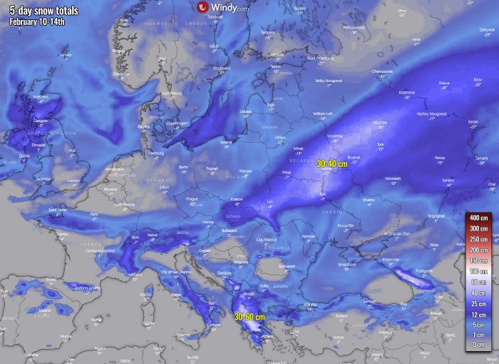
Attached below is the total snowfall amount over the next five days. We can easily notice the Wednesday’s frontal system snow swath from central France across the Alps, becoming very deep snowpack across eastern Europe.
And also the 2nd system crossing southern Italy on Friday, escalating over the far southern Balkans on Saturday into the weekend. A huge amount of snow is likely over Greece.
***The images used in this article were provided by Windy, Wetterzentrale and WXCHARTS.


