February is the last month of the meteorological winter season. This year, it will really do winter justice, ending the season with very cold weather across the United States and Europe, before eventually, Spring weather will arrive in March.
Current forecasts call for a very dynamic and cold rest of the month across much of the United States and parts of Europe. But early signs are now emerging that the Polar Vortex is re-organizing and gathering strength, which could turn the weather around towards the end of the month.
WINTER 2020/2021 WEATHER SO FAR…
In meteorology, the winter season covers 3 months: December, January, and February. This is also the official period where all the winter weather statistics are being recorded.
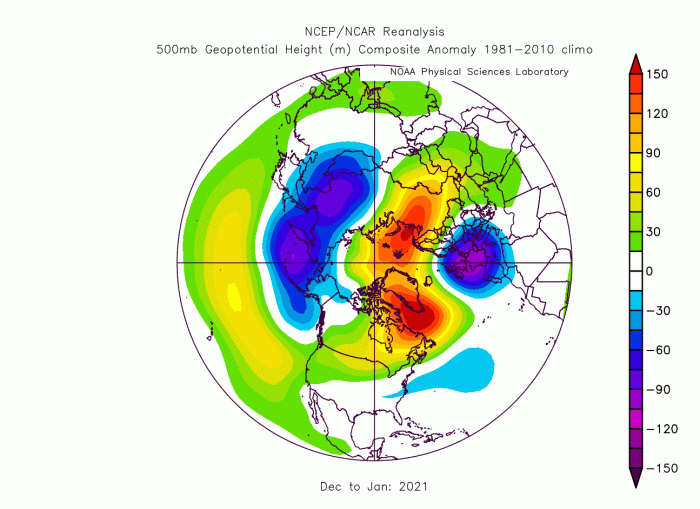
So far, Winter has shown a very dynamic pattern, with a very wavey jet stream. The image below shows the pressure anomaly pattern for December and January. The dominant feature for weather development is the high-pressure over the Greenland area, extending into and over the Polar circle.
Such an area of high-pressure can cause quite a disturbance in the circulation. We produced a high-resolution video example of this disturbance, in December and January. The video below shows the temperature at 500mb level (~5km altitude) and is a great example to showcase the polar circulation.
You can nicely see how the polar circulation is not spinning in a simple cyclonic fashion across the Northern Hemisphere. Instead, we have a quite disrupted flow, with occasional colder air extensions into the United States and Europe.
Looking closer at December 2020, we already witnessed strong blocking in the North Atlantic and over Scandinavia and the Urals. This produced a response in lower pressure over northwestern Europe. Over North America, no dominant strong low-pressure area stands out.
The temperature analysis for December 2020 shows much of Europe and North America warmer than normal. The exception is the British Isles and the southeastern United States. A strong cold anomaly was present over central Asia.
January 2021 has featured a serious upgrade when it comes to the blocking weather patterns. A much stronger high-pressure system emerged over the North Atlantic, covering Greenland and eastern Canada and connecting into the Arctic regions.
The temperature response was also a bit different, mostly in Europe, where western and northern Europe featured lower than normal temperatures. Most of North America was warmer than normal, especially eastern Canada under the high-pressure system. There were heavy winter storms across the United States, where normal to colder temperatures are indicated on the map in southcentral regions.
POLAR VORTEX COLLAPSE
The main player behind this powerful high-pressure system was the stratospheric Polar Vortex collapse.
To give you a quick idea of what the Polar Vortex is, you can imagine it like a very large cyclone, covering the whole north pole, down to the mid-latitudes. It is strongly present at all levels, from the ground up into the Stratosphere.
The stratosphere layer is around 30 km thick and is very dry. This is where the famous Ozone layer can be found. You can see the layers of the atmosphere on the image below, with the troposphere on the bottom and the Stratosphere with the ozone layer above it.
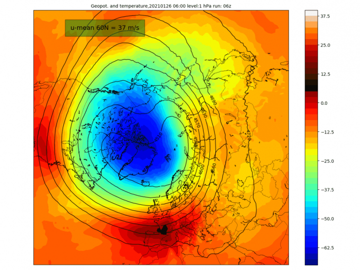
The image below shows a typical example of the Polar Vortex at around 46km altitude (1mb level) near the top of the stratosphere. It is like one big cyclone, spinning over the Hemisphere, and is connected down all the way to the lower levels. If you disrupt this circulation, the disturbance can go all the way to the lower levels, impacting the pressure systems and of course the weather.
If the stratospheric polar vortex is strong, that means that it speeds up the polar circulation. This stabilizes the jet stream and lowers the pressure over the North Pole. What this means, is when the polar circulation is strong, it locks the colder air up into the polar regions. If you want cold air outbreaks and snowfall, you want to see a weak circulation and a disrupted jet stream. That allows the cold air to spill out of the polar regions, into Europe and the United States.
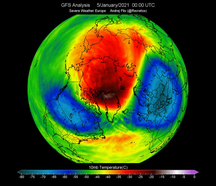
Below we have an image that shows this heavy disruption of the polar vortex at the 10mb level (~30km altitude). A strong stratospheric warming event has disrupted the polar vortex, pushing it out of the Polar Circle, and greatly disrupting the flow.
When trying to find a connection between the stratosphere and our winter weather, it helps to have more specialized images at hand. Especially one that shows weather over altitude and time.
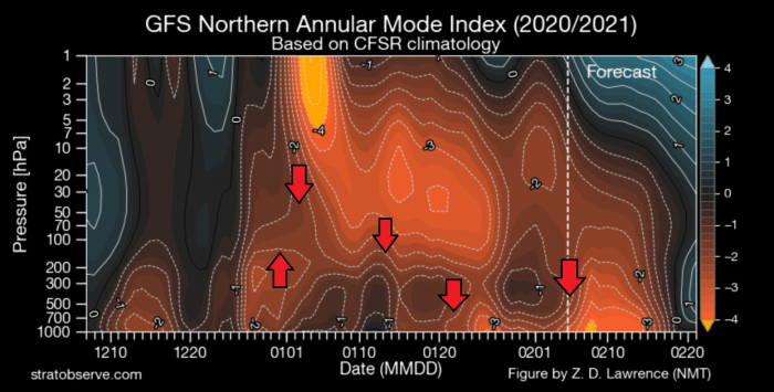
The image below shows an atmospheric pressure index. Negative values indicate higher pressure and positive values indicate lower pressure. You can see altitude from the ground up to the top of the stratosphere (~46km), over time.
You can see strong negative values in the stratosphere in early January, associated with the higher pressure buildup during the stratospheric warming event. You can see that this event and/or its influence was slowly descending over time, disrupting the circulation, reaching the lower levels by mid and late January.
The strong connection from this polar vortex collapse event is seen in mid-January and is extending further into February. So essentially, the weather we will feel in February is in a large part influenced by the stratospheric warming event that occurred in early January.
We will include a link at the bottom, to one of our specialized articles on this topic. It goes more in-depth to explain what this stratospheric warming event is and how is it so influential for weather development.
FEBRUARY 2021 – WEEK 1 WEATHER
As you have seen on the last image above, the high pressure near the surface was heavily influenced by the early January stratospheric events, with the impact being felt well into February.
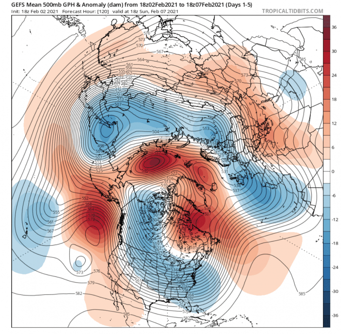
You can see this high-pressure anomaly in the week 1 chart below. Crawling over Greenland and eastern Canada, the high-pressure area is extending into the Arctic region. This prompts a low-pressure response over northern and western Europe and of course over western Canada down into the United States.
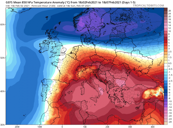
Looking closer at Europe, colder air was present over the northern and northeastern regions. The continent was split into two weather poles, with colder in the north and warmer in the south.
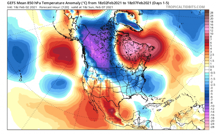
The weather over North America had a similar response, with cold pooling over western Canada and extending down into the northern, central, and eastern United States, with some of the coldest temperatures this season so far.
FEBRUARY 2021 – WEEK 2 WEATHER
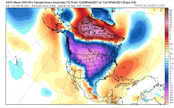
Going into week 2 and actual forecasts, you can see the consolidating high-pressure system over Greenland and Canada. It has moved further towards the polar circle, enabling the southward movement of very cold weather into North America.
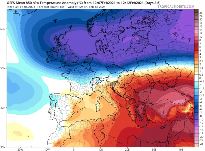
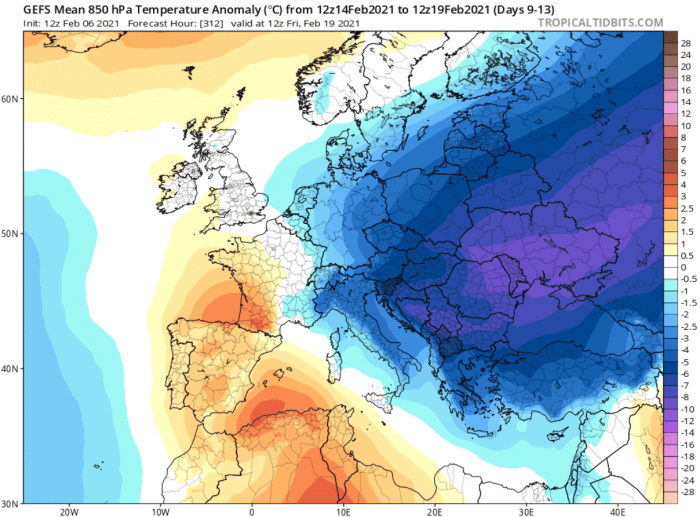
A high-pressure area spins clockwise. This means that high pressure over the polar regions promotes easterly flow into Europe. Below you can see the much colder than normal temperatures making their way from the east into northern and central Europe. This is unofficially known as the “Beast from the east”.
A true cold-weather beast is setting up over North America in week 2. An actual batch of cold Arctic air will be unleashed from Canada into the United States. At many places, the temperatures will be lowest this winter so far, or perhaps even the coldest in the past few winters.
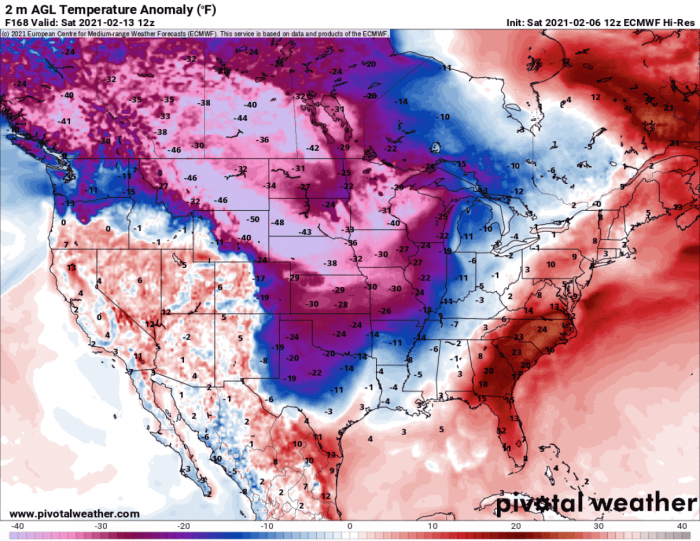
Looking closely at surface temperature anomalies, you can see a typical “deep freeze” situation unfolding. Surface temperatures will drop between 30°F to 50°F below the normal values for this time of the year.
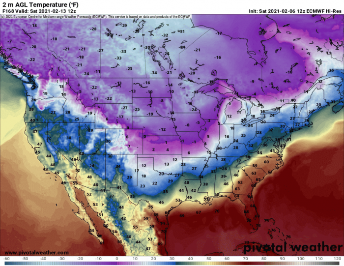
Actual temperatures will be ranging from 0°F to -30°F across much of the north-central and northern United States.
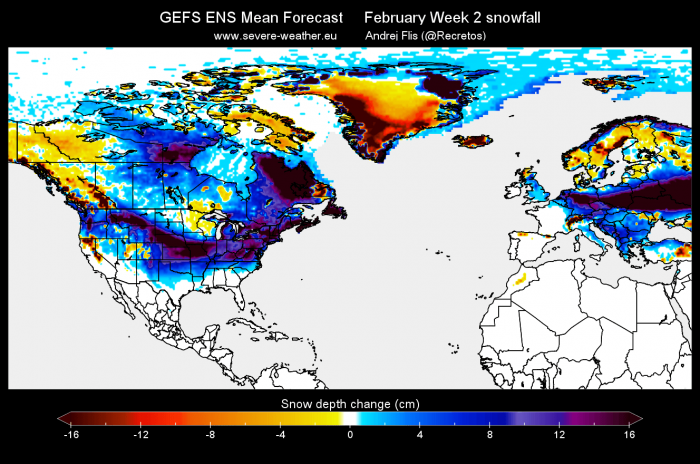
Such cold events usually also mean snowfall. The GEFS snow depth forecast for week 2 of February, shows the snow depth increase on both sides of the Atlantic. Europe will have most of the snow depth increase in a belt from the British Isles across central Europe towards the east.
A massive area of snow depth increase is also forecast across most of the United States, from the northwest across the central regions into the northeast. Eastern Canada is also going to see a decent snow depth increase.
FEBRUARY 2021 – WEEK 3 WEATHER
Not a lot will change in week 3, as the high-pressure system will still be dominant over the Greenland area. It will move closer towards Europe, affecting the temperature distribution there, while still keeping lower pressure over western Canada and the northern United States.
As the high-pressure system gets closer to Europe, the easterly flow can move further towards the south. This means that colder air transport from the east would be focused also on central and southern Europe. Snowfall potential is dependant on the positioning of the low-pressure areas and the available moisture.
Over North America, the Arctic air outbreak persists, with much of the country experiencing the lowest temperatures of the winter season. No quick warming period is seen at the moment in week 3, but the cold should subside slowly as the air spills across the continent.
Some of the coldest weather with the lowest temperatures will be seen right at the beginning of week 3. Surface temperatures are expected to drop from 30°F to 50°F below the long term average for this time of the year, extending from the northwestern United States into the central regions.
The actual temperature forecast reveals surface temperatures in the negative values covering a large part of the country, with single-digit temperatures covering over a third of the country.
FEBRUARY 2021 – WEEK 4 WEATHER
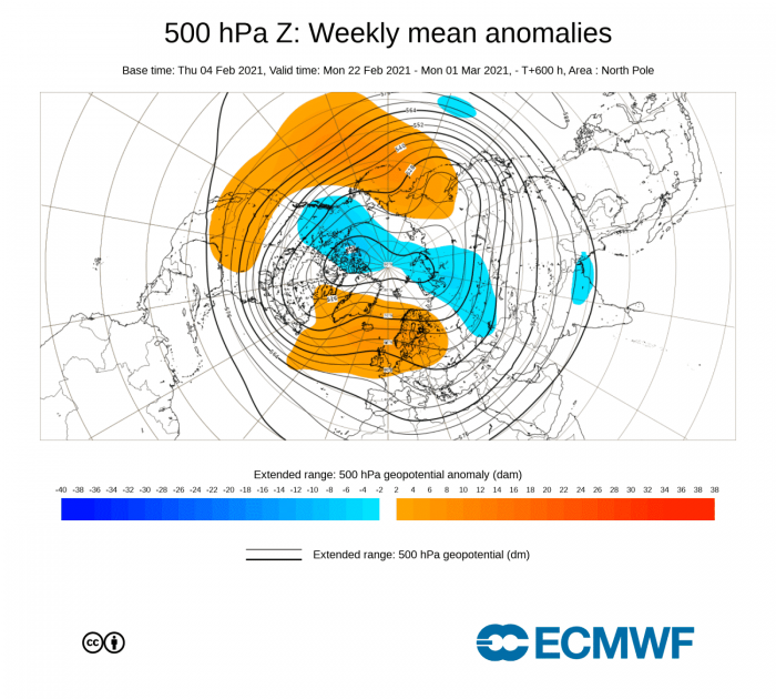
February week 4 weather is much more uncertain, where we only have basic trends to lean on. The forecast from ECMWF calls for the continuation of the high-pressure system over Greenland, extended towards northern Europe. You can also see lower pressure remains over western Canada and also likely over the northeastern united states, in tandem with the high-pressure area over Greenland.
The temperature forecast calls for more of the easterly colder flow into eastern and parts of central Europe. Over North America, you can see the stable cold air region over western Canada, but with a likely colder region over the eastern or northeastern United States. Warmer air is slowly flowing from the south, as the cold air outbreak from week 2 and 3 clears out.
There are still a lot of unknowns around this final week of February, especially for the United States. There, a lot depends on the strength and the positioning of the high-pressure system in the pacific and the west coast. With a strong ridge over the west coast, new cold-weather Arctic outbreaks can be initiated into the north, central, and the eastern United States.
MARCH 2021 – SPRING WEATHER AND THE POLAR VORTEX
No king rules forever, and no pressure system spins forever. Looking ahead into March 2021, you can see the current forecast calls for lower pressure over the North Pole. Notice the strong high-pressure system over the North Pacific, likely simulated as a typical response to the La Nina.
At this point, most of the central and eastern United States is warmer than normal, as is also Europe. When pressure drops over the Polar Circle, the circulation stabilizes, locking the colder air into the polar regions. It is still possible to get a cold air outbreak out of it, but it is usually just transitional, and not long-lasting.
One of the reasons that the pressure might drop over the polar regions is perhaps in the Polar Vortex we mentioned earlier. If the polar vortex strengthens, it can stabilize the polar circulation, and also stabilizing the weather. This means less volatile patterns and a reduced number of cold air outbreaks.
We usually look at the speed of the stratospheric zonal (west to east) winds to estimate the strength of the polar vortex. The forecast below shows the current values at 15m/s which is fairly low. But as you can see, the winds are forecast to increase, indicating a strengthening of the polar vortex in the second half of February.
Looking at the pressure anomalies with height on the image below by Simon Lee, you can see the forecast for the second half of the month. Lower pressure (negative values – cold colors) is slowly set to return, to the surface layers, connecting up into the stratosphere with the strengthening polar vortex.
This process would mean a likely slow end to the main winter mode across the Northern Hemisphere, and Spring slowly making its way into Europe and parts of southern and central United States in early March.
A lot depends on the strengthening process of the stratospheric polar vortex. If successful in powering up, it could connect to our weather, stabilizing the circulation and enabling early Spring.
You can learn more in our specialized article on the polar vortex and its collapse, and the subsequent weather influence and importance:
Polar Vortex collapse and weather impacts across North America and Europe
We will keep you updated as fresh data is available, and more reliable forecasts are released, so check back for fresh updates!
