While hurricane Epsilon* is still ongoing over open waters of the northwestern Atlantic, the focus is now turning into the Caribbean. Convective storms became better organized on Friday and the potential is increasing a Tropical Storm Zeta is likely to form soon. The system will gradually move across Cuba and towards the Bahamas or South Florida over the weekend. The flooding threat will increase.
The tropical disturbance/wave currently has a designated name #95L by NOAA NHC.
Should the system grow into a named tropical storm, it would become Storm Zeta. The next name on the 2020 Atlantic hurricane season list. The current record for the earliest 27th Atlantic named storm formation is November 29th, 2005.
Zeta is the sixth letter of the Greek alphabet and was last used in 2005. The only other year that the Greek alphabet was in use.
The environmental conditions across the Caribbean Sea appear very conducive for further development, as an MJO wave is now supporting upper-level diverge over the region. A tropical depression will likely form over the weekend and gradually continue toward the northwest.
Heavy rains from this system will affect Cuba, Jamaica, the Bahamas, the Cayman Islands, South Florida, and the northeast Yucatan Peninsula through Monday.
If/When Storm Zeta forms, it will be lined with the names used in the 2005 hurricane season. Any storms beyond Zeta would bring us deeper into the Greek alphabet list, so unprecedented records.
The 2020 Atlantic Hurricane Season ends at the end of November, while the most active years have seen storms forming also in the off-season in December before.
2020 hurricane season is very likely on the way to develop more storms in the coming weeks and could generate more than 30 named storms in one season.
*Hurricane Epsilon will soon begin an extratropical transition and merge with a large upper trough and a low pressure to its north on Sunday. It will become a powerful extratropical storm. Weather models are hinting its central pressure could dip below 940 mbar on Tuesday when it will travel south of Iceland towards western Europe.
HURRICANE SEASON 2020 SO FAR
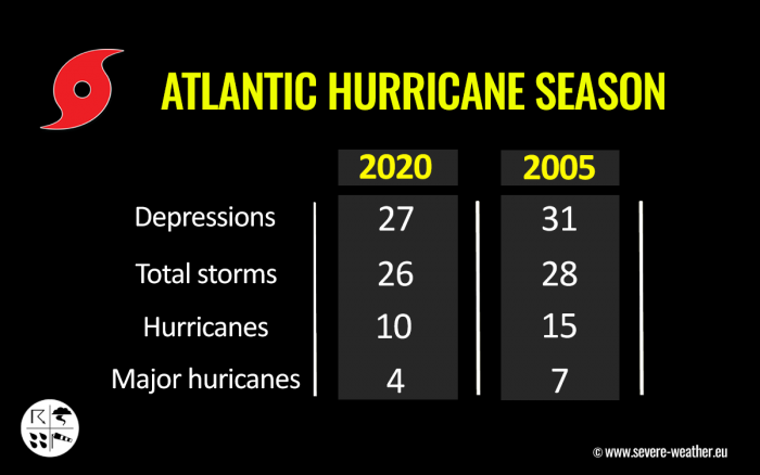
The Atlantic hurricane season has been a record-setting for named storms to date, Oct 24th. There were 26 named storms, which is nearly 240 % of the long-term average (10.8) for this time period. So far, there were almost double the number of hurricanes (10) and four major hurricanes (Laura, Teddy, Delta, and Epsilon).
24 storms out of those 26 total, had the earliest formation date on record.
Major hurricanes Laura, Teddy, and Delta have all peaked at Category 4 strength. Major hurricane Epsilon peaked at Category 3 strength while passing near Bermuda on Wednesday, Oct 21st.
Laura and Delta both made destructive landfalls in Louisiana.
The Atlantic, Caribbean region, the Gulf of Mexico, and the East Coast of the United States were also the most active tropical regions globally this year.
There have been 91 named storm days, which is around 170 % of the average number (52.4). Other forecast parameters, including hurricane days, major hurricanes, and major hurricane days are also much above the average.
Accumulated Cyclone Energy (ACE index)
The Accumulated Cyclone Energy is the energy output of a hurricane season, calculated as an index (ACE index). It is a metric used to express the energy used by a tropical cyclone during its lifetime.
The index calculation takes the cyclone’s maximum sustained winds every six hours and multiplies it by itself to generate the values. The total sum of these values is calculated to get the total for a storm.
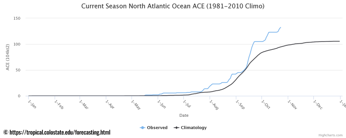
The current Atlantic basin ACE is, as of October 23nd, held at 132.4. That is almost 40 percent higher than during a normal season to this date (94.7).
The highest ACE so far this season was generated by Teddy (27.8), Paulette (15.9), Delta (15.7), and Laura (12.8). Hurricane Epsilon has generated an ACE of 9.25 so far, as of Oct 23rd.
INCREASED TROPICAL ACTIVITY OVER CARIBBEAN
Satellite images and radar data on Friday indicated that the broad area of low pressure was located just west of Grand Cayman Island. The surface low is gradually becoming better defined now.
As can be seen from the animation below, there is an increased surface convergence, as indicated by the uptick in westerly inflow. This is a sign that surface pressure is falling in association with the broad low-pressure system over the western Caribbean.
Water vapor satellite imagery indicates healthy moisture is present and the environmental conditions support low shear in the region. This is a sign that further development is likely and a tropical depression could develop this weekend. It is quite likely that the disturbance will become Tropical Storm Zeta by Monday.
The cyclonic system has developed low-level spiral bands with an impressive upper-level outflow toward the north.
HOT CARIBBEAN WATERS REMAIN
Both the environmental and oceanic conditions across the Caribbean region remain very favorable for tropical development. While the wind shear is only around 10 knots, the sea-surface temperatures are very warm. 29-30 °C (84-86 °F) are reported over the western Caribbean, so storms have a lot of ocean fuel to maintain their activity.
Additionally, there is a very moist atmosphere with a mid-level relative humidity near 75 %.
SYSTEM WILL HEAD TOWARDS CUBA AND FLORIDA
According to the NHC, the system could move near western Cuba by Sunday and move slowly across the southeastern Gulf of Mexico by early next week. Interests in western Cuba, the Florida Keys, and southern Florida should monitor the progress of this disturbance.
The National Hurricane Center (NHC) is giving the system a 90 % chance that a tropical storm Zeta will form in the coming days.
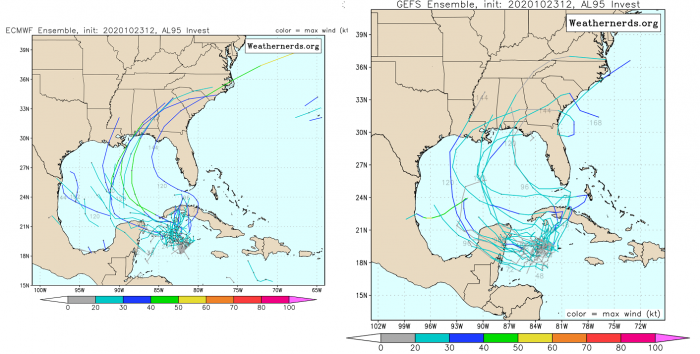
As the system is still developing, there are rather high uncertainties regarding the potential track of forthcoming Storm Zeta. As seen on the ECMWF and GEFS forecast tracks below, the tropical disturbance will move towards the northwest first.
Then, it might continue into the Gulf of Mexico or curve across western Cuba towards South Florida. The interaction with Cuba’s terrain could have a strong effect on the system as well and disturb its further organization.
Nevertheless, conditions are forecast to remain favorable for further development through Monday as wind shear will remain relatively low around 10-20 knots with the sea-surface temperatures of near 29 °C (84° F), and plenty of moisture in the mid-levels.
So the evolution of this tropical disturbance surely needs close attention. If it holds together up to the southern portions of the Gulf, heavy rain and flooding threat will be possible over South Florida as well.
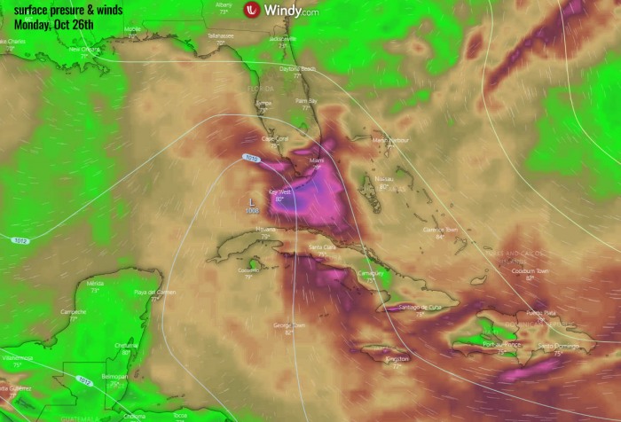
As can be seen from the chart by Windy.com above, the ECMWF global model it hinting a Tropical Storm formation by Monday. The center of the low would be near Key West or northwest Cuba.
FLOODING POTENTIAL FOR CUBA AND SOUTH FLORIDA
Regardless of development into depression or storm, locally heavy rainfall is expected. Precisely over portions of the Cayman Islands, Jamaica, Cuba, southern Florida, the Florida Keys, and the northwestern Bahamas through the weekend.
Different weather models are hinting 4-8 inches (100-200 mm) will be possible across the swath to the east of the tracking center of the system.
Flash floods are possible to occur, including landslides over the higher terrain of Cuba.
HURRICANE SEASON IS NOT OVER YET
The official hurricane season for the Atlantic Basin (the Atlantic Ocean, the Caribbean Sea, and the Gulf of Mexico) is from June 1st to November 30th. The peak of the season is from mid-August to late October.
By October 24th, the 2020 hurricane season now still has about 35 days left until we close the books at the end of the season.
At the beginning of the hurricane season, NOAA, TWC, and NCSU forecasters predicted: “There will be 13 to 22 named tropical storms in 2020, where 6-9 of those would reach hurricane strength, and 3-4 of them attaining major strength.” The official name list had 23 names reserved this year.
As of Sept 18th, the list usage has been completed as all the reserved names were already used by that date. Since then, the Greek alphabet list is in use.
And we are now almost at the 6th Greek alphabet letter, likely to be used for the next storm name this weekend.
MADDEN-JULIAN OSCILLATION (MJO)
The Madden-Julian Oscillation (MJO) is the largest and most dominant source of short-term tropical variability, it is an eastward-moving wave of thunderstorms, clouds, rain, winds, and pressure. It circles the entire planet on the equator in about 30 to 60 days.
At the end of October, a new wave will re-emerge from the eastern Pacific into the Caribbean region. It will also extend into early November.
The MJO consists of two parts: one is the enhanced rainfall (wet) phase and the other is the suppressed rainfall (dry) phase. This means there are increased storms and rainfall on one side and reduced storms and drier weather on the other side.
The air parcels are diverging (moving away) over the wet phase, and converging (moving together) over the dry phase. This horizontal movement of air is referred to as the Velocity Potential (VP) in the tropics.
We are able to track the entire MJO wave movement by looking at the larger scale air parcels movement. With the weather model data, we can easily see the areas where the air is rising and where it is subsiding.
Another important factor is the Ocean Heat Content (OHC). OHC takes into account the depth of the sea, and how warm the water layers are deep below the sea surface. In this month, we can still see a large pool of high available heat energy with a very warm water layer running down quite deep.
Deepwater being so warm as this season, provides a very favorable environment of a thick layer of warm water. Tropical systems are fueled by these warm layers, as deep convective storms draw energy from hot water.
Long story short: the thicker the warm layers are, the more fuel/energy is available to feed the storms.
The above graphics, provided by Michael J. Ventrice, Ph.D. represent an MJO wave with filtered VP200* anomalies for the current state, for the week 1 forecast, and for the week 2 forecast. Cold colors are representative of a more favorable state over the Atlantic for tropical cyclogenesis while warm colors represent a less favorable state for tropical cyclogenesis.
*VP200 – means a Velocity Potential (VP). It is an indicator of the large scale divergent flow, so at upper levels in the tropics. The negative VP anomalies (shaded blue in the diagram) are closely tied to the divergent outflow from enhanced convective regions.
It is an obvious sign that during the week 1 forecast (end of October), the MJO wave will emerge into the Caribbean region, lowering the pressure and providing a strong boost to thunderstorm activity.
Activity seem to continue into early November, given the very favorable pattern per week 2.
CAN WE SEE MORE THAN 30 NAMED STORMS IN 2020?
With the forthcoming tropical storm Zeta possibly soon, there will be no names left beyond the existing record of 6 Greek alphabets used in 2005. Tropical Storm Zeta was the last storm name that was designated by the National Hurricane Center in 2005, the only year using the Greek alphabet prior to the 2020 Atlantic hurricane season.
Based on the current statistics, the Atlantic hurricane season 2020 is only two named tropical storms away from the record of 28 named storms in 2005. For example, the 2005 season had eight (8) additional storms forming in October itself and a few more later in November. Some storms formed even past the official end of the season in December.
With potentially a few more storms forming in November, we are definitely aiming towards Nu or Xi storm names. That is halfway through the Greek Alphabet names.
There seems to be a fairly high probability that the well-above-average western Atlantic and Caribbean region sea temperatures would be favorable for tropical storm formation even in December this year.
Nevertheless, there is still a long way to go before we will be closing the books of this historic 2020 Atlantic hurricane season.

