The extremely warm Western Caribbean Sea churned yet another potentially dangerous storm – Tropical Storm Zeta has formed on Sunday morning. Zeta will intensify into a hurricane and first make landfall in Yucatan, then head into the Gulf and potentially for the 11th landfall of a tropical system in the United States mainland next week.
Hurricane warning for the central Gulf Coast ahead of the re-emerging Zeta, landfall is now expected near New Orleans on Wednesday
It has been less than three weeks since Hurricane Delta made landfall in Louisiana. But the Caribbean region is now ramping up. Tropical Storm Zeta has formed overnight and will turn towards the Gulf of Mexico and probably also towards the Gulf Coast of the United States.
Hurricane warning has been issued for portions of the Yucatan peninsula.
Tropical Storm Warning has been issued for Western Cuba.
The National Hurricane Center (NHC) warned, that “through Wednesday, heavy rainfall is expected from Tropical Storm Zeta across portions of central and western Cuba, the Cayman Islands, Jamaica, the northeast Yucatan peninsula of Mexico, Southern Florida, and the Keys. This rainfall may lead to flash flooding in urban areas”.
Zeta is the 27th named storm of the 2020 Atlantic hurricane season to date and also the earliest forming 27th Atlantic named storm on record. The system breaks the previous t record for the earliest Atlantic 27th named storm formation that was November 29th, 2005.
The tropical disturbance/wave had a designated name #95L by NOAA NHC and has been upgraded to a tropical depression on Saturday but soon intensified into a Tropical Storm.
Zeta could become a hurricane while heading towards the northeast over the next few days. There is an increasing potential for a dangerous landfall in the Yucatan peninsula, Mexico on Tuesday.
Greek alphabet storm names
Zeta uses the sixth letter of the Greek alphabet that was last used in 2005. The only other year that the Greek alphabet was in use. Now, any additional storm names will go into uncharted territory, so we will be dealing with unprecedented records.
The environmental conditions across the Caribbean Sea are very conducive for further development, as a strong MJO wave is now supporting upper-level divergence over the region.
Heavy rains from this system will affect Cuba, Jamaica, the Bahamas, the Cayman Islands, South Florida, and the northeast Yucatan Peninsula through Monday.
The 2020 Atlantic Hurricane Season ends at the end of November, while the most active years have seen storms forming also in the off-season in December before.
2020 hurricane season is very likely to generate more than 30 named storms in one season.
Don’t miss: Hurricane Epsilon will soon begin an extratropical transition and merge with a large upper trough and a low pressure to its north on Sunday. It will become a powerful extratropical storm. Weather models are hinting its central pressure could dip below 940 mbar on Tuesday when it will travel south of Iceland towards western Europe.
We will have an update on this on Monday.
HURRICANE SEASON 2020 SO FAR
The Atlantic hurricane season has been a record-setting for named storms to date, Oct 25th. There were 27 named storms, which is about 250 % of the long-term average (10.8) for this time period. So far, there were almost double the number of hurricanes (10) and four major hurricanes (Laura, Teddy, Delta, and Epsilon).
25 storms out of those 27 total, had the earliest formation date on record.
Major hurricanes Laura, Teddy, and Delta have all peaked at Category 4 strength. Major hurricane Epsilon peaked at Category 3 strength while passing near Bermuda on Wednesday, Oct 21st.
Laura and Delta both made destructive landfalls in Louisiana. And what weather models are now hinting with the Tropical Storm Zeta, it could head for the Gulf Coast of the United States – there are quite some chances it could reach Louisiana. Again.
The Atlantic, Caribbean region, the Gulf of Mexico, and the East Coast of the United States were also the most active tropical regions globally this year.
There have been 93 named storm days, which is around 176 % of the average number (52.9). Other forecast parameters, including hurricane days, major hurricanes, and major hurricane days are also much above the average.
Accumulated Cyclone Energy (ACE index)
The Accumulated Cyclone Energy is the energy output of a hurricane season, calculated as an index (ACE index). It is a metric used to express the energy used by a tropical cyclone during its lifetime.
The index calculation takes the cyclone’s maximum sustained winds every six hours and multiplies it by itself to generate the values. The total sum of these values is calculated to get the total for a storm.
The current Atlantic basin ACE is, as of October 24th, held at 135.3. That is almost 42 percent higher than during a normal season to this date (95.5).
The highest ACE so far this season was generated by Teddy (27.8), Paulette (15.9), Delta (15.7), Laura (12.8), and Epsilon (12.0 – as of Oct 24th).
CARIBBEAN CHURNS A NEW STORM
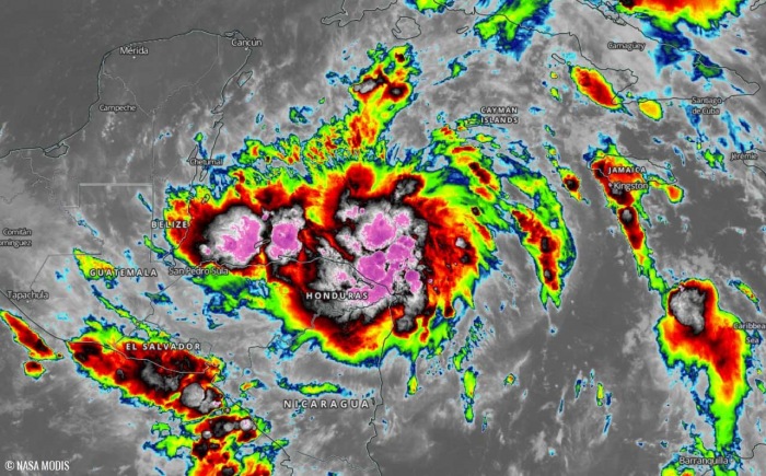
Recent satellite images indicated that the broad area of low pressure is generating explosive storms with intense convection in the southern semicircle of the cyclone’s large circulation.
The NOAA hurricane hunters reconnaissance aircraft was also scanning Zeta and has found estimated surface winds of around 35 knots. Therefore, the disturbance was upgraded to a Tropical Storm Zeta.
As can be seen from the animation below, there is a really intense convection ongoing, with cloud tops below -85 °C. Water vapor satellite imagery indicates the cyclonic system has already developed low-level spiral bands with impressive upper-level outflow ventilation.
Graphics for the video animation are provided by Tropical Tidbits.
The environmental conditions remain very conducive for further strengthening in the coming days, so Zeta seems to have an easy job to become the 11th hurricane of the 2020 Atlantic season.
ZETA HEADS FOR LANDFALL IN YUCATAN FIRST
According to the NHC, Zeta is expected to bring Hurricane conditions and storm surge in portions of the northern Yucatan Peninsula of Mexico Monday night and early Tuesday. Tropical storm conditions could occur over extreme western Cuba on Monday.
The National Hurricane Center (NHC) is forecasting that Zeta will move generally northwest and have landfall in Yucatan on Tuesday morning, likely as a Category 1 hurricane.
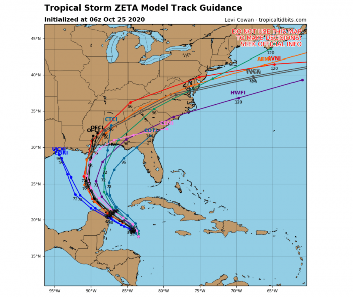
As the system is still developing, there still some uncertainties regarding the potential track after Zeta passes near or over the peninsula. As seen by the various model forecast tracks below, Zeta is quite likely on the way for landfall in Yucatan first.
But then the potential impact along the Gulf Coast is yet to be defined. The system should continue into the Gulf of Mexico while maintaining its hurricane strength until it has support from the warm Gulf waters.
However, weakening is likely prior to landfall in the United States due to cooler waters present along the Gulf Coast.
As can be seen from the chart above, the ICON model it hinting the landfall of Tropical Storm Zeta in the northeast part of the Yucatan peninsula, south of Cancun.
Mexican city Cancun was badly hit by hurricane Delta in early October.
Nevertheless, conditions are forecast to remain favorable for further development through Monday as wind shear will remain relatively low with the sea-surface temperatures of near 29 °C (84° F), and plenty of moisture in the mid-levels.
POTENTIAL INCREASING FOR THE GULF COAST
Zeta is forecast to approach the northern Gulf Coast on Tuesday night into Wednesday as it will be moving quite fast after it is past the Yucatan peninsula. It could bring storm surge, heavy rainfall, and wind impacts to areas from Louisiana to the Florida Panhandle.
Residents in these areas should monitor the progress of Zeta in the following days.
Flash floods are possible along the path of Zeta and especially enhancing landslides potential across the higher terrain of Cuba while the core passes to the west of the country.
HURRICANE SEASON IS NOT OVER YET
The official hurricane season for the Atlantic Basin (the Atlantic Ocean, the Caribbean Sea, and the Gulf of Mexico) is from June 1st to November 30th. The peak of the season is from mid-August to late October.
By October 25th, the 2020 hurricane season now still has about 35 days left until we close the books at the end of the season.
At the beginning of the hurricane season, NOAA, TWC, and NCSU forecasters predicted: “There will be 13 to 22 named tropical storms in 2020, where 6-9 of those would reach hurricane strength, and 3-4 of them attaining major strength.” The official name list had 23 names reserved this year.
As of Sept 18th, the list usage has been completed as all the reserved names were already used by that date. Since then, the Greek alphabet list is in use.
And we are now already at the 6th Greek alphabet letter, while additional letters are very likely to be used in the following weeks.
MADDEN-JULIAN OSCILLATION (MJO)
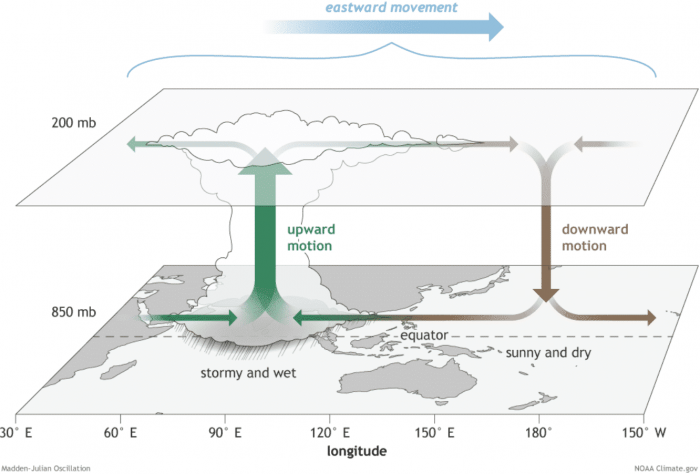
The Madden-Julian Oscillation (MJO) is the largest and most dominant source of short-term tropical variability, it is an eastward-moving wave of thunderstorms, clouds, rain, winds, and pressure. It circles the entire planet on the equator in about 30 to 60 days.
At the end of October, a new wave will re-emerge from the eastern Pacific into the Caribbean region. It will also extend into early November.
The MJO consists of two parts: one is the enhanced rainfall (wet) phase and the other is the suppressed rainfall (dry) phase. This means there are increased storms and rainfall on one side and reduced storms and drier weather on the other side.
The air parcels are diverging (moving away) over the wet phase, and converging (moving together) over the dry phase. This horizontal movement of air is referred to as the Velocity Potential (VP) in the tropics.
We are able to track the entire MJO wave movement by looking at the larger scale air parcels movement. With the weather model data, we can easily see the areas where the air is rising and where it is subsiding.
Another important factor is the Ocean Heat Content (OHC). OHC takes into account the depth of the sea, and how warm the water layers are deep below the sea surface. In this month, we can still see a large pool of high available heat energy with a very warm water layer running down quite deep.
Deepwater being so warm as this season, provides a very favorable environment of a thick layer of warm water. Tropical systems are fueled by these warm layers, as deep convective storms draw energy from hot water.
Long story short: the thicker the warm layers are, the more fuel/energy is available to feed the storms.
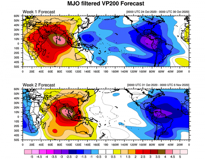
The above graphics, provided by Michael J. Ventrice, Ph.D. represent an MJO wave with filtered VP200* anomalies for the current state, for the week 1 forecast, and for the week 2 forecast. Cold colors are representative of a more favorable state over the Atlantic for tropical cyclogenesis while warm colors represent a less favorable state for tropical cyclogenesis.
*VP200 – means a Velocity Potential (VP). It is an indicator of the large scale divergent flow, so at upper levels in the tropics. The negative VP anomalies (shaded blue in the diagram) are closely tied to the divergent outflow from enhanced convective regions.
It is an obvious sign that during the week 1 forecast (end of October), the MJO wave will emerge into the Caribbean region, lowering the pressure and providing a strong boost to thunderstorm activity.
Activity seem to continue into early November, given the very favorable pattern per week 2.
MORE THAN 30 NAMED STORMS IN 2020?
As Tropical Storm Zeta has formed, additional storm names will head into an uncharted area past the existing record of 6 Greek alphabets used in 2005. Tropical Storm Zeta was the last storm name that was designated by the National Hurricane Center in 2005, the only year using the Greek alphabet prior to the 2020 Atlantic hurricane season.
Based on the current statistics, the Atlantic hurricane season 2020 is only one system away from the record of 28 named storms in 2005. For example, the 2005 season had eight (8) additional storms forming in October itself and a few more later in November. Some storms formed even past the official end of the season in December.
With potentially a few more storms forming in November, we are definitely aiming towards Nu or Xi storm names. That is halfway through the Greek Alphabet names.
There seems to be a fairly high probability that the well-above-average western Atlantic and Caribbean region sea temperatures would be favorable for tropical storm formation even in December this year.
Nevertheless, there is still a long way to go before we will be closing the books of this historic 2020 Atlantic hurricane season.
DON’T MISS:
Thinking of a nice Christmas gift for your friends, family, or someone special to you? Weather calendar could be the perfect gift for them – see below:


