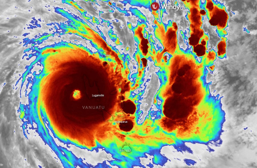
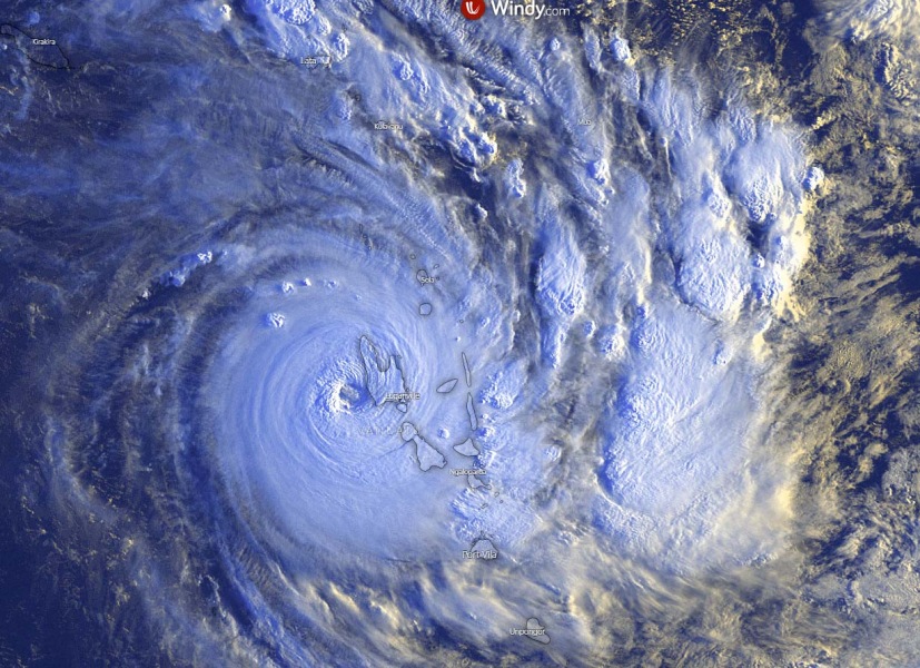
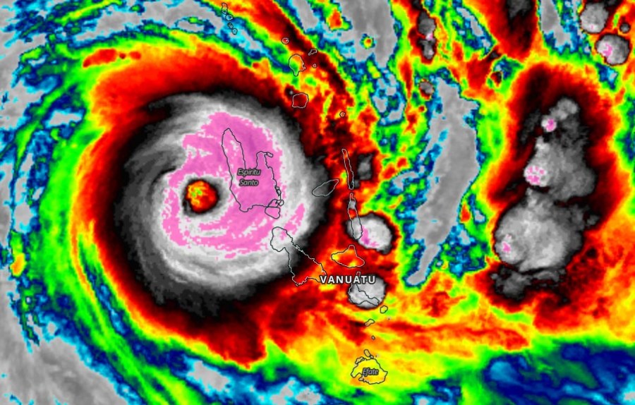
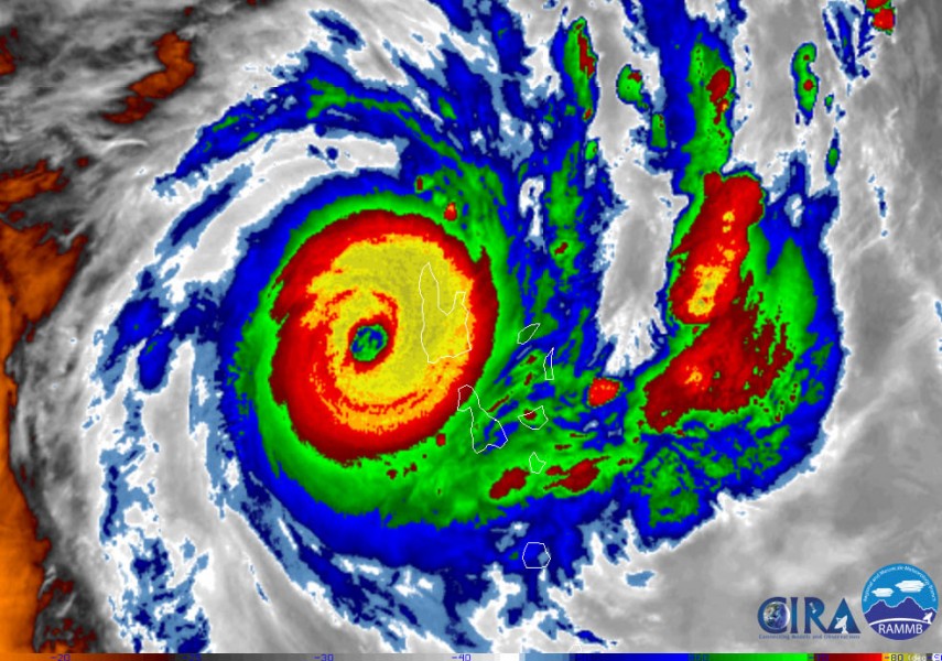
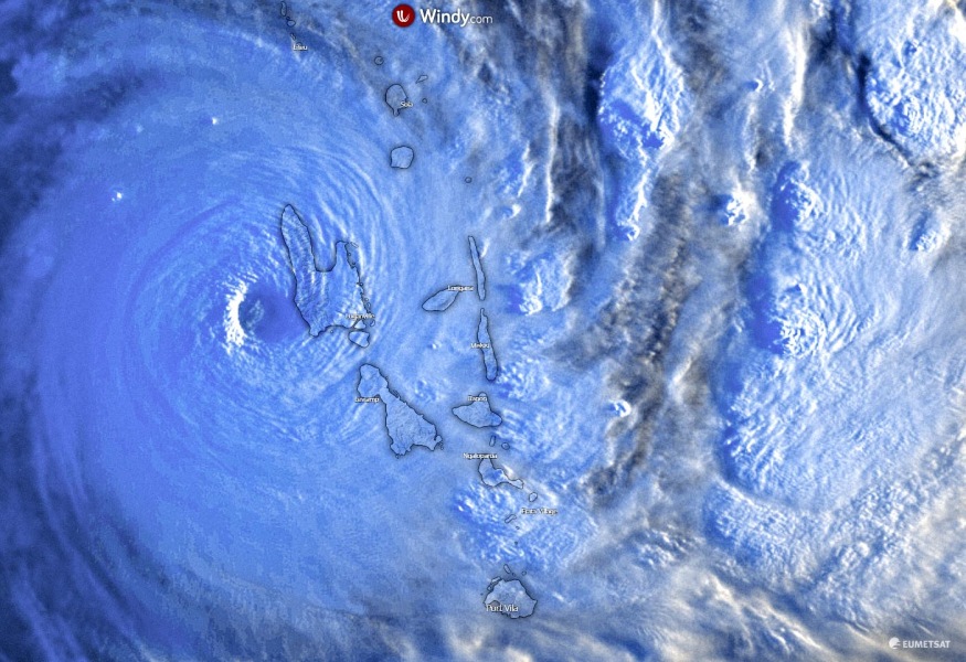
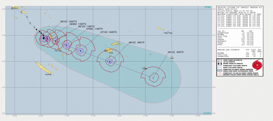
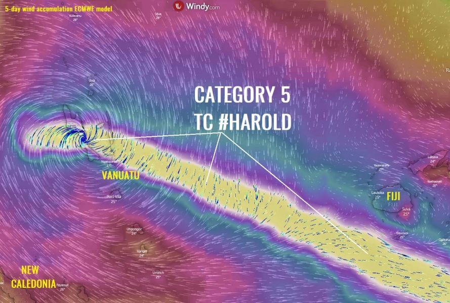
Tropical Cyclone #Harold has done an unprecedented intensification into a powerful monster tropical system. It is packing 120 knots (140 mph / 225 km/h) maximum sustained winds and 936 mbar (914 mbar per Vanuatu Met. office) central pressure. This officially puts Harold into a Category 5 system, based on the Australian/Fiji classification. That is a Category 4 equivalent tropical system based on the Saffir-Simpson scale. Harold is already affecting the westernmost islands Espiritu Santo and Malakula, and continue due east at slow speed. This will be destructive for the archipelago over the next 24-36 hours as Harold’s very slow movement across the islands will result in significant wind damage and flooding.
**************************
**************************
The satellite imagery is beyond exceptional. Soon after Harold completed the EWRC (Eyewall replacement cycle), a very large eye appeared with a fully closed eyewall and almost symmetrical CDO (Central dense overcast) cloud signature. A truly remarkable monster system. This is the worst-case scenario for the Vanuatu islands, as there is basically no return now. The full force of a violent system will blast across the country. Also, a very interesting thing happened a few hours ago – it seems that Harold’s eye began to clear soon after the outflow ‘shockwave’ pushed to the N and NW. This shockwave can be seen on 3rd animation below:
Exceptional satellite animation of a *monster* Category 5 Tropical Cyclone #HAROLD moving into #Vanuatu! Destructive 120-130 knot winds will graze the archipelago over the next 24 hours. Source: @tropicaltidbits pic.twitter.com/Ehhm3QSHJE
— severe-weather.EU (@severeweatherEU) April 5, 2020
https://twitter.com/StuOstro/status/1246860728792944642
https://twitter.com/DylanFedericoWX/status/1246815961908498433
Le cyclone #Harold est sur le point de toucher terre au nord des îles de #Vanuatu en cat.4 avec des vents de plus de 215 km/h et une pression de 914 hpa !!! #mm pic.twitter.com/7V60hFtiU5
— Sophie Colombani (@AS_Colombani) April 5, 2020
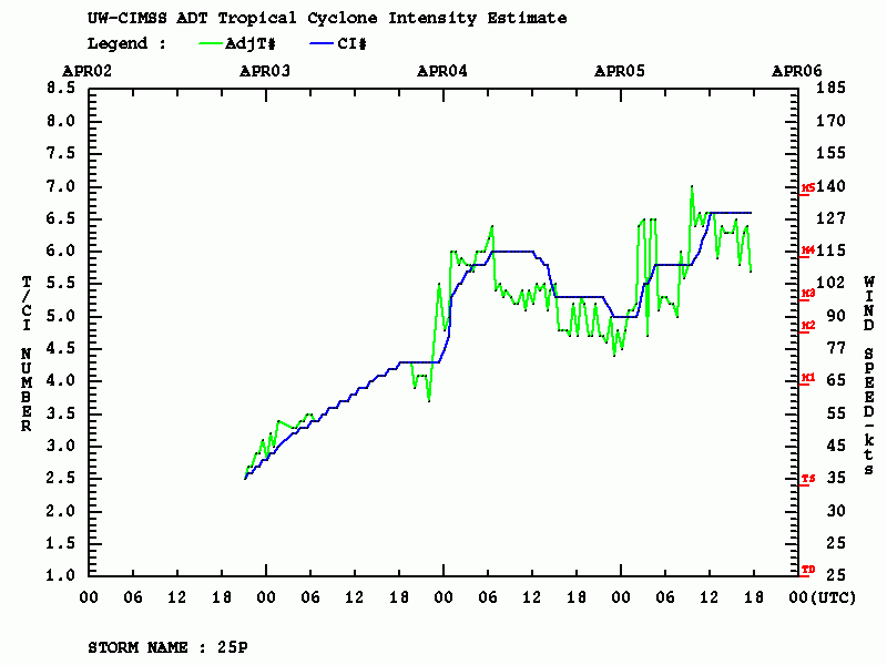
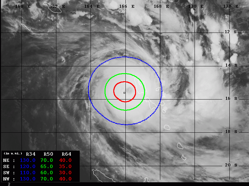
Advanced Dvorak Technique (ADT) estimates suggest the strength of Harold is relatively stable at 130 knots lately, with the minimum central pressure near 930 mbar. A volatile environment can also be seen as Harold’s intensity was changing from strong Category 3 to 5, back to 4 and again exploded into a Category 5, due to an EWRC. Soon after 12 UTC (Apr 5th), EWRC was completed and Harold has built up a very large eye, surrounded by intense 115-130 knots eyewall winds. It is holding the final T number around 6.5 – approx. 130 knots for the past several hours. The 50-knot wind radii are extending 60-70 miles around the center, covering the whole island Espiritu Santo and already the northern parts of Malakula island. Destructive, hurricane-force 64-knot winds, are grazing across the 30-40 miles radii around the center, already affecting the western part of Espiritu Santo island. 34-knot wind radii are more than 120 miles wide!
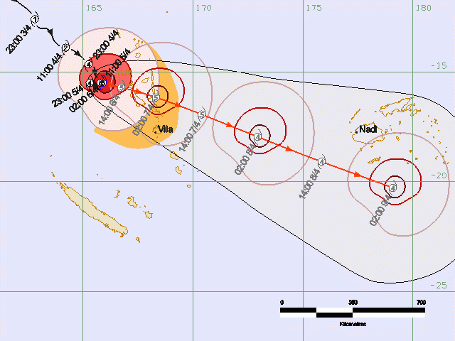
Based on the JTWC 12 UTC analysis, Harold had 120 knots of maximum sustained winds and central pressure 936 mbar. This might be slightly underestimated. The Vanuatu meteorological service is giving an official Category 5 strength of Harold, with 914 mbar minimum central pressure. The most likely track will bring Harold between the islands Espiritu Santo and Malakula first, then it will continue east and likely cross between the islands Pentecost and Ambrym. Nevertheless, Harold is a very large system and its powerful wind force is so huge, all these islands will be significantly affected by destructive winds. The most intense winds are indeed where the inner eyewall will travel, approx. 30-50 miles around the cyclone’s center. Once Harold ejects of Vanuatu on Tuesday, it will continue towards the southeast and could pass over the southern part of the Fiji archipelago. But the exact track will be better defined after Harold finishes its interaction with Vanuatu – stay tuned!
Le #cyclone #Harold au stade de cyclone tropical intense depuis plusieurs heures avec des rafales de l'ordre de 250 km/h près du centre et une pression estimée à 950 hPa va impacter les #Vanuatu ces prochaines heures.
Modélisation AROME 1.3 kmhttps://t.co/WEo6CUYwEU pic.twitter.com/VJ1LnMxtwj
— Meteociel (@meteociel) April 5, 2020
Ce n'est que dans le courant de la nuit prochaine que le cyclone #Harold devrait commencer à se déplacer vers l'est/sud-est en direction de Malakula #Vanuatu : https://t.co/6n3OB12Wko pic.twitter.com/3BTRV0odUd
— Keraunos (@KeraunosObs) April 5, 2020
Auf den betroffenen Inseln ist bis Montag mit erheblichen Schäden zu rechnen. Hier die Animation des Mittelwindes (m/s) bis Dienstag. Diese und mehr Vorhersagekarten zu #Harold: https://t.co/pDCiVpvVh1 /FR pic.twitter.com/dH9NZL71MD
— Kachelmannwetter (@Kachelmannwettr) April 5, 2020
Official forecast discussion by Vanuatu meteorological service:
*******
Tropical Cyclone Warning Number 20 for SANMA, PENAMA and MALAMPA Provinces.
Tropical Cyclone Warning Number 20 on Severe Tropical Cyclone HAROLD issued by the Vanuatu Meteorology and Geo-Hazards Department, Port Vila at 3:09am VUT Monday 6 April 2020 for SANMA, PENAMA and MALAMPA Provinces.
At 2:00am local time, Severe Tropical Cyclone HAROLD [914hPa] has now increase to Category 5 and was located at 15.5 degrees South 165.9 degrees East. This is about 140KM west of Luganville and 185KM west northwest of Malekula. The system is positioned at the center right of the square letter E, number 5 (E,5) of the Vanuatu Tropical Cyclone Tracking Map. Severe Tropical Cyclone HAROLD has been moving slowly in a north northeasterly direction at 7KM/HR (4Knots) in the past 3 hours.
Maximum sustained winds close to the centre are estimated at 215KM/HR (115Knots). Severe Tropical Cyclone HAROLD is forecast to be at 15.7 degrees South 166.7 degrees East in the next 24 to 48 hours.
Damaging gale force winds of 90KM/HR (47Knots), gusting to 110KM/HR (55Knots) affecting SANMA, PENAMA and MALAMPA Provinces tonight and and continuing tomorrow and extending to SHEFA province in the next 6 to 12 hours.
Destructive storm force winds of 120KM/HR (63Knots) with gusts up to 150KM/HR (80Knots) within 40 Nautical miles from its center will be affecting SANMA province for the next the next 6 to 12 hours and later extending to MALAMPA and PENAMA provinces.
Hurricane force winds of 215KM/HR (115Knots), gusting to 235KM/HR (125Knots) within 20 Nautical miles from its center are also expected to affect SANMA province and extending to MALAMPA and PENAMA provinces in the next 12 to 24 hours.
*******
This tropical cyclone will be destructive for Vanuatu islands, wherever its eye passes. Violent winds of 120-130 knots sustained speeds will be devastating in some areas. Together with very intense rainfall and destructive flash floods, including landslides. Stay alert for life-threatening conditions! We will be updating again soon – stay tuned!
See the previous discussions:
