Tropical storm conditions are expected near the center of Claudette and to the east of it along portions of the Central Gulf Coast over the weekend. Areas with the highest risk are from east of Morgan City, Louisiana, across New Orleans to the Okaloosa/Walton County line, Florida. Heavy rainfall with urban flooding along is expected, then also extend towards Southern Appalachians after the landfall. Claudette will be the first Tropical Storm landfall of the Hurricane Season 2021.
Tropical storm warnings are in effect for parts of Louisiana, Mississippi, Alabama, and Florida. Louisiana has declared a state of emergency as up to about 20 inches of rain could fall over the weekend and cause significant flooding. The same area was hit already hard by heavy rain and flooding over the last month.
Tropical Storm Claudette is expected to produce heavy rainfall with urban flash flooding through Friday night and continuing over the weekend along the Central Gulf Coast.
Here is the ongoing intense deep convection over the northern portions of the Gulf, already affecting the Gulf Coast of Louisiana, Mississippi, Alabama, and Florida Panhandle. Very moist air mass and Gulf temperature fuel the storms to the east of Claudette’s center.
The outflow ventilation is quite impressive on the above satellite scans, meaning that Claudette continues gaining strength.
Claudette is the third tropical storm of the hurricane season 2021 that officially began on June 1st. The Atlantic hurricane season runs between June 1st and November 30th, although storms could also develop outside the official dates.
HURRICANE SEASON 2021 SO FAR: TROPICAL STORM ANA and BILL
The first tropical cyclone of the hurricane season 2021 was Tropical Storm Ana which has formed on May 22nd, 10 days before the official start. The peak intensity of Ana was 40 knots and it also generated an ACE of 1.01.

Earlier this week, a second named system – a Tropical Storm Bill formed several hundred miles east off the coast of North Carolina on Monday night and lasted for about 48 hours only.
Bill remained over the open waters of the Atlantic and reached its peak intensity of 60 knots and the minimum central pressure of 998 mbar.
Note: An average Atlantic hurricane season typically ends up with 14 named tropical storms, 7 hurricanes, and also about 3 major hurricanes. The hurricane season has two peaks, one happens in early/mid-September and the second one in mid-October. The overall activity normally begins increasing with August.
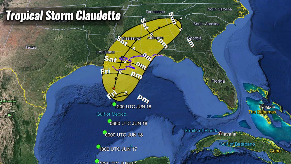
TROPICAL STORM CLAUDETTE HEADS FOR THE GULF COAST LANDFALL
Now, the Gulf Coast is in for the very first landfall of a Tropical Storm in the hurricane season 2021. Claudette will bring massive rains and locally significant flooding on Saturday.
Deep convection has become better organized on Friday, and tropical-storm-force winds are expected to remain until the landfall along the Central Gulf Coast. The activity, however, remains confined to the eastern side of the circulation, thanks to the about 20 knots of wind shear present.

The leading edge of the system has already reached portions of the Central Gulf Coast, with heavy rainfall developing. Conditions are expected to continue deteriorating through Friday night into Saturday.
Claudette is moving north-northeastward at about 12 knots of forwarding speed and this movement should continue until the landfall in southeastern Louisiana through Saturday morning. After the landfall, Storm Claudette will take a turn to the right and move across the southeast United States as it becomes embedded in the westerly flow aloft.
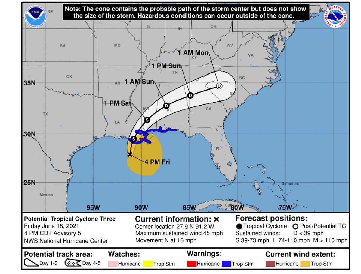
Any potentially significant strengthening is not likely given the pretty asymmetric structure of the system, the moderate wind shear, and limited-time over the warm Gulf of Mexico waters. A longer time could strengthen it to the hurricane force, but fortunately, Claudette will make landfall sooner.
Tropical Storm Claudette will bring a significant amount of rain to the immediate east of the tracking center, locally more than 15 inches will be possible until Monday. This will worsen the ongoing high river waters and cause dangerous urban and river flooding.

Tropical-storm-force winds will also bring the storm surge, potentially 2-3 feet along the Central Gulf Coast. A combination of the storm surge and the high tide will cause the areas near the coast to be flooded by rising waters, moving inland from the shoreline.

These areas also include Lake Pontchartrain, Lake Maurepas, and Mobile Bay.
WARM TROPICAL ATLANTIC COULD MEAN BUSY HURRICANE SEASON
So far this June, the subtropical Atlantic is much warmer than normal and the tropical Atlantic is near its long-term average. Statistically, this region with above-normal sea surface temperatures (SST) in the tropical Atlantic has a pretty good correlation with what’s the typical June SST pattern when an above-normal hurricane season has resulted.
The tropical Atlantic Basin sea waters are pretty warm, ranging from around 27 °C in the central region, up to around 28-29 °C across the western Caribbean. Similar temperatures, 28-30 °C are spread across the whole Gulf of Mexico, being the highest over the western parts of the Gulf.
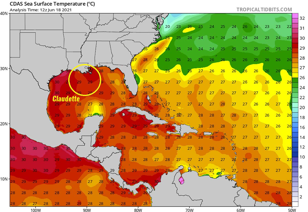
This area is exactly where the focused tropical storm Claudette has developed. Warm seas are helping to fuel the convective storms as we could see on the satellite above. There are also very hot sea waters on the Pacific side, along western Mexico, reaching up to around 31 °C where a Tropical Storm Dolores, the 4th of the season there, is underway.
Dolores will make landfall in western Mexico this weekend, bringing dangerous heavy rainfall and flooding.
The sea surface temperature anomaly chart below also shows that the whole Atlantic Basin, including the Caribbean and the Gulf of Mexico, has water temperatures warmer than normal. Sea temperatures are especially anomalous across the western Gulf (marked as (1)), along the US East Coast, and further east across the Atlantic (2).

As we can see from the chart above, the sea surface temperatures in the MDR region (Main Development Region – between Africa and the Caribbean Sea) are also much warmer than normal. This usually means that the potential for tropical cyclone formations will easily fuel from the very warm tropical Atlantic ocean waters.
Very high sea temperatures usually lead to rapid or even explosive development and therefore strengthening of tropical cyclones. Many storms or hurricanes in the past years took a rapid intensification with an abnormal gain of intensity in a matter of 24 to 36 hours.
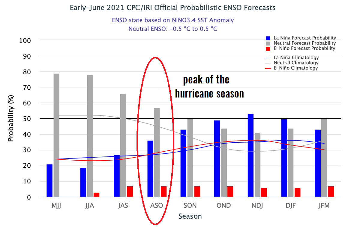
Earlier this spring 2021, NOAA has officially declared that the La Nina global weather pattern has ended and the tropical Central Pacific waters have gone into a neutral phase. While the Atlantic, the Caribbean, and the Gulf have very warm and above normal seawater conditions this year, and those are expected to continue, the neutral ENSO conditions will very likely boost the activity through the peak months of the hurricane season 2021.
Another factor, besides the warm water temperatures, is also very important for the tropical cyclone formation. This is the so-called MJO wave. MJO is an abbreviation for the Madden-Julian Oscillation and is the largest and most dominant source of short-term tropical variability. It is an eastward-moving wave of thunderstorms that circles the entire planet on the equator in about 30 to 60 days.
HURRICANE SEASON 2021 FORECAST
For the Atlantic hurricane season 2021, the international committee of the World Meteorological Organization (WMO) has designated 21 tropical cyclone or storm names. These are starting with Ana and ending with Wanda. The first two storms, Ana and Bill, were already used, now the third storm of this season is Claudette.
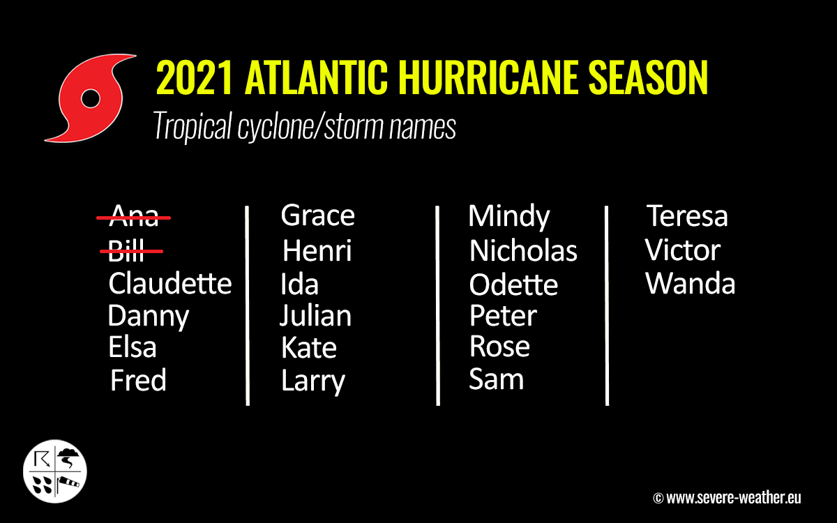
In the beginning, the Atlantic tropical cyclone names were used from lists originated by the National Hurricane Center, and are in use since 1953. Nowadays, tropical cyclone names are maintained and updated by an international committee of the WMO. The hurricane name lists are used in rotation and re-cycled every 6 years, so the tropical cyclone names list of 2021 will be used again in 2027.
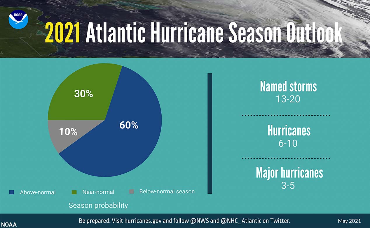
The Colorado State University (CSU) forecast calls for 18 named storms with the Atlantic hurricane season 2021. The Weather Company (TWC) is forecasting 19 named storms, the United Kingdom’s Met Office (UKMO) about 14, while the NOAA’s Climate Prediction Center issued their forecasts predicting a 60% chance of above-average activity with 13-20 named storms, 6-10 hurricanes and 3-5 major hurricanes.
The Accumulated Cyclone Energy (ACE) could end up around 150 which is about 22 % above the normal for the 1991-2020 period. The ACE index is a metric that is used to express the energy used by a tropical cyclone during its lifetime.
***The images used in this article were provided by Wxcharts, Tropical Tidbits, and Windy.