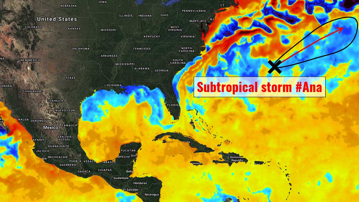
A tropical storm Ana has formed east of Bermuda early Saturday morning, May 23rd, and it is the first named storm of the Atlantic hurricane season 2021. Over the last 7 years, all the hurricane seasons had at least one named storm prior to the official start of hurricane season on June 1st.
Ana formed about 180 miles northeast of Bermuda and is almost stationary, forecast to wobble around the current position before turning towards North Atlantic in the coming days and gradually dissipate while moving into colder waters and increasing wind shear.
Such a pre-season activity over the last 15 years isn’t too unusual, as nearly half of the seasons had an earlier start than the official date of June 1st. In 2020, there were two tropical storms forming before June first, Arthur and Bertha. These early starters have also prompted the National Hurricane Center to start with their tropical outlooks on May 15th instead of at the official start date one would expect.
Typically, the first named storm in the Atlantic forms around July 10th, according to the National Hurricane Center while the first hurricane usually forms in mid-August. The most active months for tropical storms and hurricane activity across the Atlantic Basin are August, September, and October.
Below is the recent animation of the forming depression, including various satellite channels (water vapor, visible and infrared scans), indicating a tightening core spinning near the center of the tropical storm Ana. The system is very small, however, but nevertheless, it is officially the first named storm of the 2021 hurricane season.
The tropical storm Ana will, however, be rather short-lived while spinning to the northeast of Bermuda this weekend before ejecting towards the North Atlantic.
ATLANTIC OCEAN WATERS MUCH WARMER THAN AVERAGE
The Atlantic Ocean waters around the location of the ongoing tropical storm Ana are about 21-23 °C, which is relatively low compared to the usual conditions needed for tropical development. Still, these temperatures are slightly above-average for late May over this part of the Atlantic. The position of the storm Ana is marked with the white circle.

Basically, the whole Atlantic basin, including the Caribbean region and the Gulf of Mexico already have seawater temperatures quite a lot warmer than normal for this time of the year. This also well correlates with what is typically seen prior to active Atlantic hurricane season.
Notice also that the seawater temperatures in the region known as MDR – Main Development Region (a region between Africa and the Caribbean Sea) are much warmer than average. This hints that upcoming tropical cyclone formation will easily fuel from the very warm ocean waters. Often with the potentially (very) rapid strengthening of tropical systems.
Note: The Atlantic basin covers the area which includes the entire Atlantic Ocean, the Gulf of Mexico, and also the Caribbean Sea.
Lately, NOAA has officially declared that the La Nina global weather pattern has slid into a neutral ENSO phase. Combined with these already above-average and warming Atlantic sea temperatures, it could spark a very active hurricane season again. Very warm seawater conditions are expected to continue throughout this year, with ENSO conditions remaining neutral through the peak months (August to October) of the hurricane season 2021.
TROPICAL STORM ANA FORMED 10 DAYS EARLIER THAN THE OFFICIAL START
A tropical storm Ana has formed east of Bermuda early Saturday morning, May 23rd, while strengthening its wind field near the core of the deepening low. The maximum sustained winds are set at 40 mph with about 1002 mbar of central pressure.
Ana made a small counter-clockwise loop during the past few hours, and the initial motion is now northeast with about 4 knots of speed only. A continued northeastward motion at an increasing forward speed, due to the southwesterly flow associated with a developing mid-latitude cyclone to the north and northwest, is expected until the cyclone dissipates.

As noted by the official forecast discussion by the NHC:
While Ana continues to produce convection near the center, the amount of convection has decreased during the past several hours. In addition, earlier scatterometer data and recent satellite intensity estimates from TAFB suggest the cyclone has weakened. The initial intensity is reduced to 35 kt.
Then, a combination of increasing shear, dry air, and decreasing Atlantic Ocean sea surface temperatures should cause Ana to gradually weaken, and most of the global models now show the system decaying to a trough on Monday. The new intensity forecast calls for a slow weakening with dissipation just after that time, and it is possible that Ana could dissipate earlier than the current forecast.
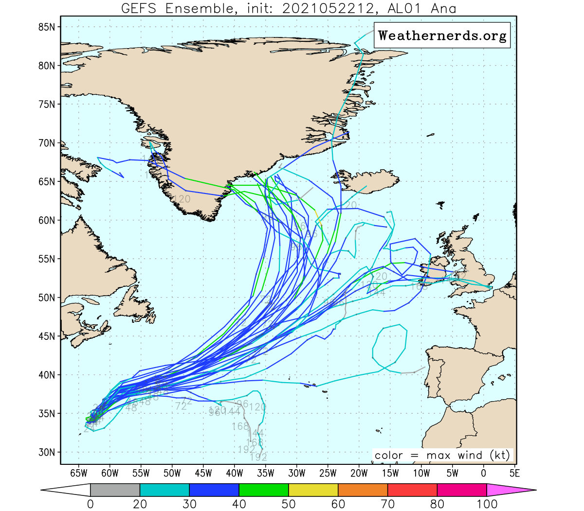
Therefore it would gradually weaken into early next week while moving towards the northeast across the North Atlantic as an extratropical (post-tropical) storm.
As we can see, the subtropical storm Ana has developed before the hurricane season 2021 has even started. In recent years, the other two storms named Ana forming before the official start of the season were observed in April 2003 and May 2015.
In 2020, there were even two systems that formed before June 1st – Tropical Storm Arthur and Bertha during the second half of May. Andrea in 2019, Alberto in 2018, and Arlene before the start of hurricane season 2017.
Officially, the Atlantic hurricane season starts on June 1st and extends until November 30th.
LATEST ATLANTIC HURRICANE SEASON 2021 PREDICTION
The international committee of the World Meteorological Organization (WMO) is officially maintaining cyclone names in tropical regions around the world. WMO has designated 21 storm names that are being reserved for the Atlantic hurricane season 2021. The hurricane name lists are used in rotation and re-cycled every six years, therefore, the list used in 2021 year will be used again in 2027.
The 2021 list with 21 names can be seen below, starting with Ana and ending with Wanda. The Atlantic tropical cyclones had been named from lists originated by the National Hurricane Center, and are in use since 1953.

As we already stated in our initial forecast discussion about a month ago, the Colorado State University (CSU) is predicting an above-average number of tropical storms and hurricanes for 2021.
And there is also another, probably the most concerning part of the forecast for the upcoming hurricane season. There is a very high, near 70 percent, chance of a major hurricane landfall along the United States coastline, and a nearly 60 percent chance for a major hurricane making devastating landfall in the Caribbean. A typical season has about a 50/50 probability of the US mainland getting hit.
Keep in mind that these forecasts need to be considered and residents along the coastal areas in the Atlantic Basin have to be hurricane aware of as we enter the new Atlantic hurricane season just 10 days from now.
The CSU forecast also includes the ACE index prediction that is forecast to be very high again this year. ACE is an abbreviation for Accumulated Cyclone Energy and it tells us how much energy storms could produce. The CSU forecast predicts an ACE of 150, which is well above the average for a typical hurricane season.
Learn what Is Accumulated Cyclone Energy (ACE) index
Scientists have set the metrics, that are used to express the energy used by a tropical cyclone during its lifetime, which is known as the Accumulated Cyclone Energy (ACE) index. It represents the calculation of the tropical cyclone’s maximum sustained winds every six hours. The number is then multiplied by itself to generate the values.
In the end, the sum of these values is calculated to get the total ACE value for a tropical storm or a hurricane and can either be divided by 10,000 to make them more manageable or added to other totals in order to work out a total for a particular group of storms.
The calculation itself was originally created by William Gray and his associates at Colorado State University (CSU). At first, they developed the Hurricane Destruction Potential index, which took each hurricane’s maximum sustained winds above 65 knots (= 75 mph or 120 km/h) and multiplied it by itself every six hours.
This index was subsequently tweaked by the NOAA in 2000 that it now includes all tropical cyclones, with maximum sustained winds above 35 knots (65 km/h = 40 mph). It was then finally renamed to an Accumulated Cyclone Energy we use nowadays.
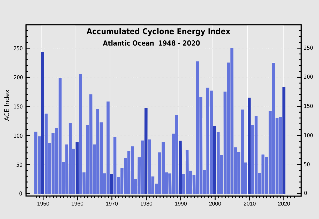
The above graphics represent the Accumulated Cyclone Energy for the Atlantic Ocean over the last 70+ years. It can easily be noticed how the recent 5 years were all pushed into an above-normal value of the ACE index, which is 111. Within the Atlantic Ocean, the NOAA uses the ACE index to classify hurricane seasons into four categories.
Extremely active – ACE index above 152.5
Above-average – ACE index above 111
Near-average – ACE index between 66 and 111
Below-normal – ACE index below 66
If we remember the record-breaking hurricane season 2020 by its numbers, the ACE ended up at 184.5, so quite well above the threshold for the ‘extremely active’ category. This also placed 2020 into the TOP-10 Atlantic hurricane seasons based on the Accumulated Cyclone Energy index.
The record holder hurricane season with the highest ACE index is 1933, ending at 258 ACE. The 2005 hurricane season which was the one with the 2nd most named storms after the 2020 season, also ended up extremely high with the final ACE of 250. As we can see, even the last year’s season had a record-breaking number of tropical cyclone formations, it doesn’t necessarily mean the Accumulated Cyclone Energy would be off the charts as well.

The above charts indicate the recent 15 hurricane season ACE records and the related number of hurricanes in that particular year.
The closest Atlantic hurricane season, fitting into an ‘extremely active’ category in recent years can be found in 2017.
Just a while back we discussed in our Atlantic Ocean discussion, much of the Atlantic Basin sea waters are already quite warmer than average. A large part of the Gulf of Mexico is also warmer than average, and so is the tropical central and western Atlantic region.
According to dr. Phil Klotzbach, the Colorado State University (CSU) predicts that all the parameters that are typically monitored during an Atlantic hurricane season are likely to be above average in 2021. The CSU University forecast hints at about 80 named storm days (that is 35 % above the long-term average), 8 hurricanes (about 25 % above average), and 4 major hurricanes (48 % above average).

The Accumulated Cyclone Energy (ACE) could end up around 150, which is about 42 % above the long-term normal for the climatological period between the 1981 and 2010 years.
NOAA ALSO CALLS FOR VERY ACTIVE HURRICANE SEASON 2021
A few days ago, the NOAA has officially released its seasonal hurricane forecasts for the Atlantic and Pacific Basins. The forecast clearly shows a very high potential for an above-normal season very likely in 2021, calling for about 13-20 named storms, and up to 10 hurricanes. Also 3-5 major hurricanes with an ACE index between 110 % and 190 % compared to the 1951-2020 median value.
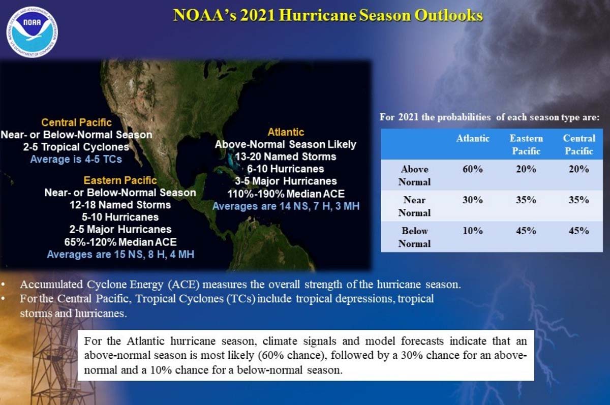
The NOAA’s Climate Prediction Center is predicting a 60 % chance for yet another above-normal hurricane season in 2021. And only a 10 % chance that it will be a below-normal season this year, which gives us a hint of how confident the forecast actually is. So like 2020, we could be soon facing a very active and dangerous 2021 hurricane season again, but for now, NOAA forecasters do not predict this year could rival the 2020 record-breaking season.
NOAA warns, that “Now is the time for communities along the coastline as well as inland to get prepared for the dangers that hurricanes can bring. The experts at NOAA are poised to deliver life-saving early warnings and forecasts to communities, which will also help minimize the economic impacts of storms.”


Note: Our team will be actively monitoring the tropical region activity worldwide, including the Atlantic Basin systems and tropical cyclones that are likely to affect both the United States and Europe again this year. Stay tuned for further follow-up posts, forecast discussions, and nowcasting during the coming weeks and throughout the entire Atlantic hurricane season 2021.
***The images used in this article were provided by Weathernerds, Tropical Tidbits, and Windy.