Severe weather outlook – forecast across Europe. This forecast features areas of organized severe weather with risk levels and severe weather threats across the European continent.
SEVERE WEATHER OUTLOOK – DAY 1
Valid: 17/06/2021 06 UTC – 18/06/2021 06 UTC
Issued by: Severe Weather Europe
Forecaster: Marko Korošec
SUMMARY
Severe storms are likely to develop across western and southwestern Europe within the warm sector and unstable air mass ahead of the Atlantic front. Organized storms, including supercell storms with large hail, severe winds, and also some tornado threats are possible.
Above: Video animation of the convective storm’s development across western Europe from the morning into the late-night hours on Thursday, June 17th, 2021.
Weather forecast overview of the risk areas across Europe

SYNOPTIC OVERVIEW
An extensive upper-level ridge is strengthening over northern and northeastern Europe into northwestern Russia. While to the west, a deep long-wave trough is emerging into western and southwestern Europe from the Atlantic.
A weak upper low is located over the southern Balkan peninsula, the Black Sea, and western Turkey.
At the surface, an unstable air mass is spread across the warm sector with the strong south-southwesterly winds aloft, extending from the Iberian Peninsula across France into Benelux. A front is extending from the parent surface low from the North Sea across the Bay of Biscay to Portugal.
WEATHER FORECAST DISCUSSION
+++ Weather forecast for France, Benelux, and Germany +++

ENH/SLGT risks have been issued for northeastern France and Benelux into west-northwest Germany and Denmark with a threat for severe damaging winds, large hail, and some tornado threats.
Storms are likely to take place with the diurnal heating over north-central France and become severe, while gradually expanding towards Benelux with time.
Within the moderately unstable and sheared environment, the strongest storms will introduce threats for large hail and severe winds. Damaging winds will be the primary threat, especially after storms merge into larger clusters while moving northeast into the night.
An MCS is likely to persist into the night hours with mainly severe winds and torrential rain threats.
+++ Weather forecast for Spain and France +++
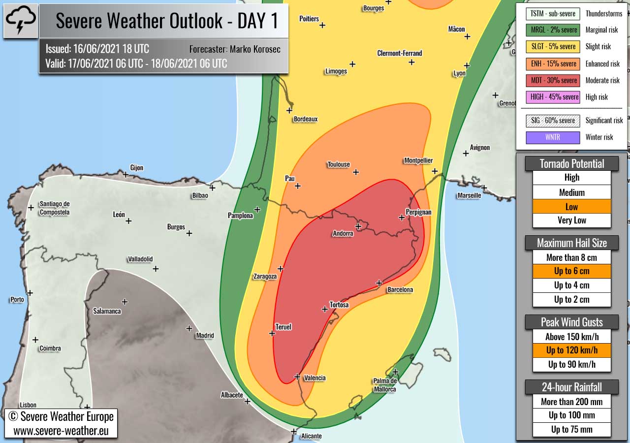
MDT risk has been issued for northeast Spain into southwestern France with a threat for very large hail, severe winds, and some tornado threats.
ENH/SLGT risks have been issued for areas surrounding the MDT risk across northeast Spain and west-southwest France with more isolated threat for organized storms.
A short-wave will translate from the central Iberia towards southern France during the day, and result in favorable upper-level forcing for rather widespread storm initiation. Organized storms, including supercells with large to very large hail, and damaging winds will be possible.
Storms will gradually merge into a larger system towards the late afternoon and evening hours with a possible MCS tracking north along with the surface low/wave into western France.
+++ Weather forecast for Ukraine into Georgia +++

SLGT risk has been issued for southern Ukraine into southwestern Russia and Georgia with an isolated threat for severe storms, capable of producing severe winds, marginally large hail, and tornadoes.
+++ other areas +++
MRGL risk has been issued for northern Algeria with an isolated threat for severe storms, capable of producing severe winds, large hail, and torrential rainfall.
Higher coverage limits the SLGT risk potential, but storms could become quite strong.
TSTM risks have been issued for areas across the Alps, the Balkan peninsula, and central Italy with a threat for daytime-driven storms. Limited shear is present, so the storms should remain sub-severe.
Follow & report severe weather events on our Facebook page:
Severe Weather Europe Facebook page
Understanding Severe Weather Outlook / Forecast for Europe
Severe Weather Outlook features areas of organized severe weather with risk levels and severe weather threats. Risk levels are divided into seven categories:
TSTM – Thunderstorms
MRGL – Marginal risk
SLGT – Slight risk
ENH – Enhanced risk
MDT – Moderate risk
HIGH – High risk
SIG – Significant risk
WNTR – Winter risk
Risk categories stand for the coverage and intensity of organized severe weather. Those could include supercells, squall lines, mesoscale convective systems, wind storms, flooding, snowstorms, or ice storms.
Severe weather threats include:
- large hail (of at least 2 cm in diameter)
- Tornadoes (including waterspouts)
- Wind gusts (convective or non-convective) above 25 m/s (or above 90 km/h)
- Torrential convective precipitation / Flash floods
- Excessive rainfall (100 mm within 12 hours) / snowfall (50 cm within 12 hours)
Extremely severe weather threats include:
- Large hail (of at least 5 cm in diameter)
- Tornadoes of F2 intensity or stronger
- Wind gusts (convective or non-convective) above 33 m/s (or above 119 km/h) or 12 Bft
- Torrential convective precipitation / Flash floods
- Excessive rainfall (150 mm within 12 hours or above ) / snowfall (above 100 cm within 24 hours)
Categories in the forecast represent the chance of severe weather occurring within a 40 km radius from a location. The used level is based on the conversion table of probabilistic risk into the outlook categories.
A threat level is upgraded into a higher category if probabilities meet the threshold criteria for the specific threat (e.g. tornado, wind, hail, or rainfall threat).
Each individual threat area includes a detailed forecast map and discussion on the potential of severe weather threats. Detailed weather forecast also includes probability levels for tornadoes, maximum hail size, peak wind gusts, and 24-hour rainfall.
Read more: Explanations for abbreviations (TSTM, SLGT, ENH, etc.)