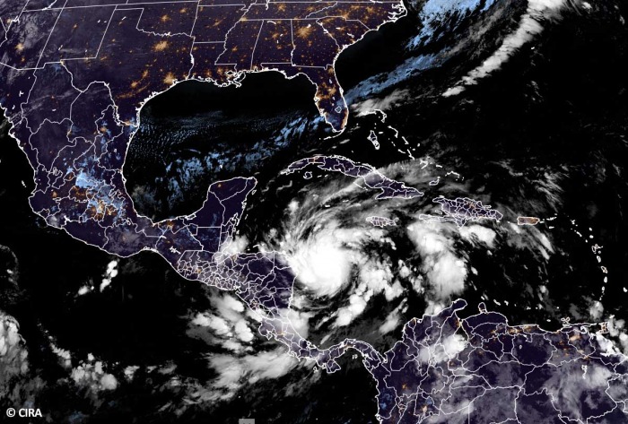
The unstoppable Atlantic 2020 hurricane season! Hurricane Eta becomes the 5th major hurricane of the season – A Category 4 storm. Extremely rapid intensification is underway this Monday. Now on the way for destructive landfall in Nicaragua on Tuesday. Catastrophic flooding, wind damage, and life-threatening storm surge are expected across northeast Nicaragua where a major hurricane will strike on Tuesday.
HURRICANE WARNING is in effect for northeast Nicaragua!
Major hurricane Eta is now, as of Nov 2nd 18 UTC update, a Category 4 hurricane with the maximum sustained winds of 130 mph (115 knots, 215 km/h) and the minimum central pressure of 948 mbar.
Eta is now the strongest November Atlantic hurricane since Paloma in 2008.
It will likely continue to strengthen additionally before it reaches the northeastern coast of Nicaragua on Tuesday. Eta may even become a borderline Category 5 storm!
And it is also the 3rd major hurricane to form in the Atlantic since October 1st, after major hurricanes Delta and Epsilon last month. This is now the first time on record that the Atlantic has had 3 major hurricane formations in October and November.
Eta is forecast to remain a Category 4 hurricane until the landfall in Nicaragua. According to dr. Philip Klotzbach, there have only been three (3) Category 4 and one (1) Category 5 hurricane in the Atlantic basin in November on record. Lenny (1999), Michelle (2001), and Paloma (2008) were all Category 4 while Cuba Hurricane (1932) was the only Category 5 November hurricane so far on record.
Catastrophic wind damage is expected where Eta will make the landfall, as destructive Category 4 hurricane-strength winds are likely within the eyewall moving onshore.
Eta will also bring a potentially catastrophic and life-threatening storm surge, along with battering waves along portions of the northeastern coast of Nicaragua near and to the north of where the center makes landfall.
The water levels could reach as high as 12 to 18 feet (3.6 to 5.5 meters) above normal tide levels in some parts of the hurricane warning area.
In addition, very heavy rainfall from Eta will likely lead to catastrophic, life-threatening flash flooding and river flooding across portions of Central America through Friday evening this week. Along with landslides in areas of higher terrain.
Flash and river flooding is also possible across Jamaica, southeast Mexico, El Salvador, southern Haiti, and the Cayman Islands.
Conditions remain supportive for more activity
A deep MJO wave is underway over the Caribbean region and the Tropical Atlantic, leading to increasing thunderstorm activity and favorable for the formation of new tropical systems.
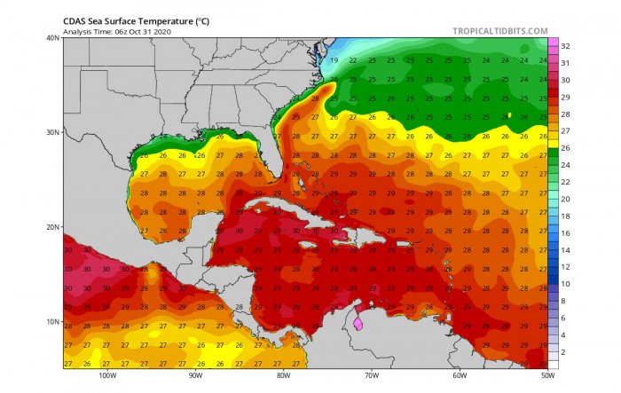
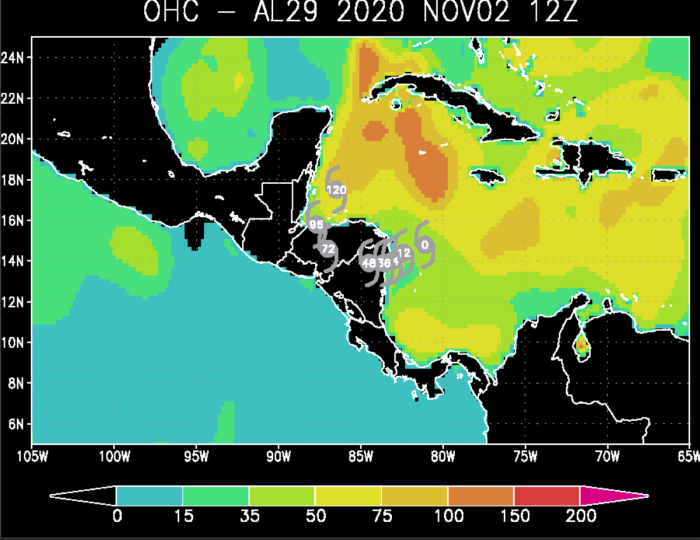
During the late season (October and November), a tropical activity gradually shifts into the Caribbean region, which has been experiencing much above normal sea temperatures this year. Extremely warm sea temperatures are also spread deeper into the ocean waters.
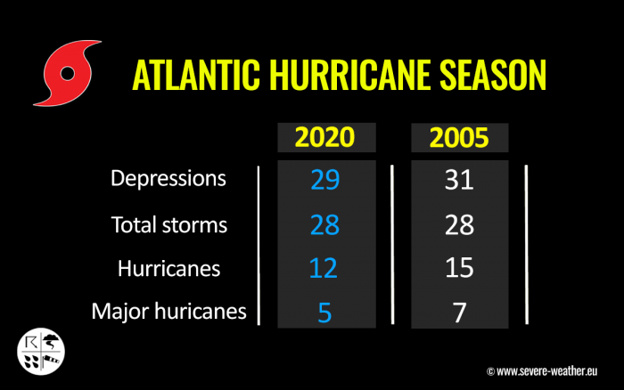
The 2020 season is now tied with the 2005 season as both had 28 named storm formations. Both years were the only ones that the Greek alphabet was in use.
Infrared, Visible and Water Vapor satellite animation of Eta:
2020 Hurricane season is now going deeper into the Greek alphabets and history books.
If Eta makes landfall as a Category 4 in Nicaragua, it would be the first since Felix in 2007 (Felix was a Category 5).
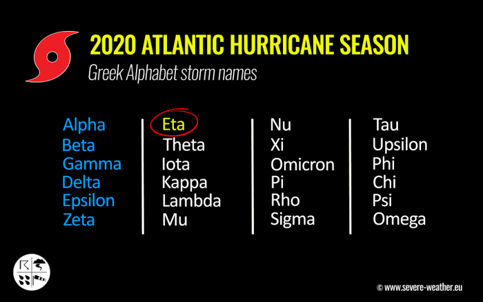
STORM NAMES ENTERING THE UNCHARTED GREEK ALPHABETS
As Hurricane Eta forms, it uses the seventh (7th) letter of the Greek alphabet. This means that the Atlantic Hurricane season is now beyond the existing record of 6 names from this list used in 2005.
Storm names are now going into uncharted territory, so we are facing an unprecedented record.
The environmental conditions across the Caribbean Sea are very conducive for further development, as a strong and deep MJO wave is now supporting upper-level divergence over the region.
The 2020 Atlantic Hurricane Season ends at the end of November, while the most active years have seen storms forming also in the off-season in December before.
The 2020 hurricane season is now very likely on the way for a new record for the most named storms in one season. Past 28 named storms from 2005. Also remember: The 2005 Atlantic hurricane season churned out powerful hurricanes like Katrina, Rita, and Wilma.
And although the intensity of the 2020 hurricane season might not be as strong as the 2005 season, we are still facing the fact, that this year could generate even more than 30 named storms in total for the season.
HOW IS THE HURRICANE SEASON SO FAR?
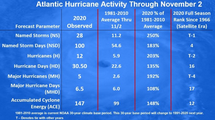
The Atlantic hurricane season remains on course for a record-setting year to date, Nov 2nd. There were 28 named storms, which is about 250 % of the long-term average (11.2) for this time period. So far, there were more than double the number of hurricanes (12) and five (5) major hurricanes (Laura, Teddy, Delta, and Zeta).
Hurricane Eta is the 5th major hurricane of the season.
26 storms out of those 28 total, had the earliest formation date on record.
Major hurricanes Laura, Teddy, and Delta have all peaked at Category 4 strength. Laura and Delta both made destructive landfalls in Louisiana. Delta’s center came ashore on October 9th and, interestingly, the landfall was just about 15 miles east of the landfall point of Hurricane Laura, which struck at the end of August.
The state of Louisiana, or better said its southern parts along the central Gulf Coast of the United States, were a hot spot so far this year. There have been 5 storms that made landfall in Louisiana. 3 of those five were hurricane landfalls (Laura, Delta, and Zeta).
Laura made landfall as a Category 4, while Delta and Zeta were a Category 2 when they came ashore in Louisiana. Laura and Delta affected the same areas with severe wind and storm surge damage. Zeta made landfall further east, due south of New Orleans.
There have been almost 100 named storm days so far, which is around 183 % of the average number (54.6). As we can see from the statistical graphics above (see the column 2nd from the right), all the forecast parameters are above average. Including hurricane days (30.5), major hurricanes (5), and major hurricane days (6.5). Provided graphics are by Dr. Philip Klotzbach.
The Atlantic, Caribbean region, the Gulf of Mexico, and the East Coast of the United States were also the most active tropical regions globally this year.
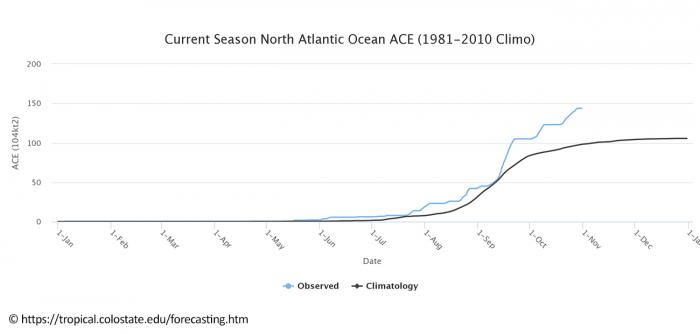
Accumulated Cyclone Energy (ACE index)
The Accumulated Cyclone Energy is the energy output of a hurricane season, calculated as an index (ACE index). It is a metric used to express the energy used by a tropical cyclone during its lifetime.
The index calculation takes the cyclone’s maximum sustained winds every six hours and multiplies it by itself to generate the values. The total sum of these values is calculated to get the total for a storm.
The current Atlantic basin ACE is, as of November 2nd, held at 146.0. That is an impressive 48 percent higher than during a normal season to this date (98.6).
The highest ACE so far this season was generated by Teddy (27.8), Paulette (15.9), Delta (15.7), Epsilon (13.1), and Laura (12.8). The last system – hurricane Zeta – added another 7.5 to the ACE index total for the Atlantic 2020 hurricane season.
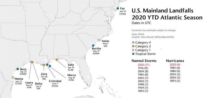
Record-breaking 11 landfalls in the Continental United States
But there is more. The 2020 Atlantic hurricane season has had a record-breaking 11 landfalls of tropical storms (or hurricanes) in the United States mainland this season.
Hurricane Delta and Zeta have helped the season to break the previous record of nine landfalling systems more than 100 years ago – in 1916.
Hurricane Delta was the first hurricane named after a Greek alphabet letter use which made landfall on the United States mainland. These are 11 named storms that made landfall in the continental United States this year (2020): Bertha, Cristobal, Fay, Hanna, Isaias, Laura, Marco, Sally, Beta, Delta, and Zeta.
And to make it even greater, there were six (6) hurricane landfall out of those 11 named storms landfall in the United States mainland. This ties with the 6 hurricane landfalls in one full season (1985 and 1886).
The 2020 hurricane season has also tied another record – there were 3 tropical storm formations in a single day. Tropical Storm Wilfred, Subtropical Storm Alpha, and Tropical Storm Beta formed on Sept 18th. This has happened only once before, in 1933.
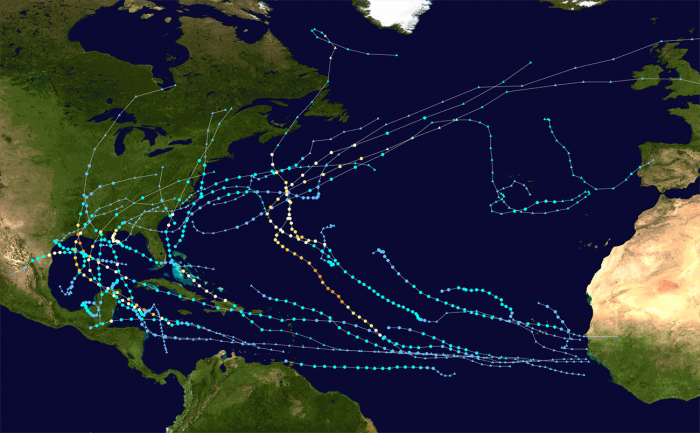
The graphics above show all the tropical storm tracks for the 2020 Atlantic Hurricane season so far. The image is provided by Wikipedia, based on the official data from the National Hurricane Center (NHC).
And now there is Eta, charting a new track in the Caribbean.
ETA’S EXPLOSIVE DEVELOPMENT INTO A CATEGORY 4
According to the National Hurricane Center (NHC), Eta has become an impressive November hurricane as it continues to undergo rapid strengthening today, Monday, Nov 2nd.
Eta has been very rapidly strengthening and is now the 5th major hurricane of the season. The sustained winds have increased from 50 knots to 115 knots over the past 24 hours – a 65 knots (75 mph) increase!
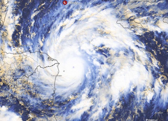
Eta is an extremely impressive hurricane in both visible and infrared satellite imagery. The hurricane has a very small pinhole eye that is located within a symmetric Central Dense Overcast with cloud top temperatures below -80 degrees Celsius.
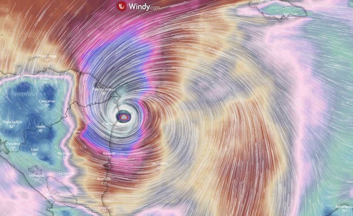
The eye has become more apparent with the recent visible satellite data, about 12 nautical miles (22 kilometers) wide. The image is provided by Windy.com.
The Air Force Reserve Hurricane Hunter aircraft that completed two center penetrations into Eta this Monday morning have reported a minimum pressure of around 972 mbar, while dropsonde observation around 100 knots (115-120 mph). This supported an upgrade of Eta into a major hurricane.
But Eta has continued explosively intensifying further.
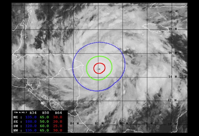
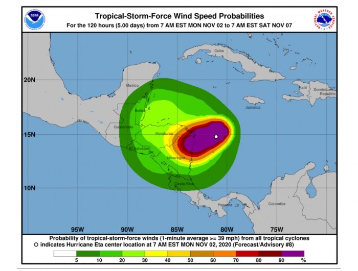
Based on the Advanced Dvorak Technique (ADT) analysis estimation Eta’s tropical-storm-force 50-knot winds are spread across the 50-70 mile radii around the eye. While hurricane Eta also has around 20-40 radii of hurricane-force 64-knot winds. The wind field is also expanding and strengthening, apready affecting the northeastern Nicaragua now.
A rapid intensification was ongoing through the past 24 hours when Eta arrived in much more favorable conditions. Extremely warm seas lead to explosive storms that Eta began rapidly deepening its central pressure.
EXTREMELY WARM WESTERN CARIBBEAN SEA
The sea surface temperatures are very warm in the Western Atlantic, and extremely warm over the Caribbean region.
There, the sea surface temperatures are reaching close to 30 °C (86 °F). Especially across the northwestern Caribbean Sea, around Cuba and Jamaica.
This is definitely a worrying sign as sea waters remain much higher than the long-term average. So the upcoming tropical systems will have the most important ingredient ready, therefore strongly supporting the rapid or even explosive development of thunderstorms.
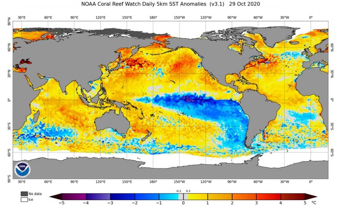
Actually, the majority of the North Atlantic, tropical Atlantic, and the Caribbean are well-above average. Also the Eastern Pacific. About 1-2 °C warmer, even more across the Northwest Atlantic.
Waters remain warm, much above the long-term average across the whole Gulf of Mexico, around Florida, the Bahamas, and along the East Coast of the United States. Definitely an important ingredient for the upcoming weeks of tropical activity.
Notice also a rapidly cooling water of the Eastern and Central Pacific – a strong Lá Nina is developing.
CATASTROPHIC LANDFALL IN NICARAGUA EXPECTED
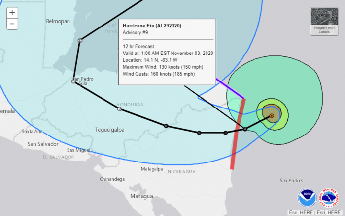
It seems that the environmental and oceanic conditions will allow additional rapid strengthening of hurricane Eta during the next 12 to 24 hours until the landfall in Nicaragua occurs. It is now becoming increasingly likely that Eta could bring a strong Category 4 (or even a Category 5) hurricane landfall on Tuesday.
The potential landfall impact is very near the city of Puerto Cabezas in northeastern Nicaragua. A city with a population near 60.000. Winds will be violent and could cause significant damage. Image is provided by Windy.com.
The hurricane is moving due westward at a rather slow speed of only around 8 kt. This is a great concern as catastrophic flooding is likely to be expected with storms maintaining for a longer period over the affected areas. As after it makes landfall in Central America, torrential rains and flooding will be a major threat from Eta.
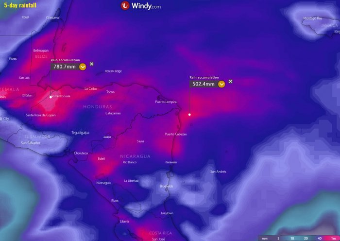
The amount of rainfall is surely the highest concern. Attached is the ECMWF and ICON model comparison. Both are simulating an extremely dangerous amount of rainfall through Friday this week. Potentially 400-700 mm will be possible.
There will also be extreme amounts of rain in northwestern Honduras – nearly 800 mm is possible by Friday.
Life-threatening flooding, river flooding, and landslides are expected.
After landfall, Eta should quickly weaken while it moves over the mountainous terrain of Central America. Eta is then forecast to turn westward, moving farther inland over Central America. The track guidance is tightly clustered during the first 48 hours or so.
ETA COULD RE-EMERGE AND TURN TOWARDS THE GULF OF MEXICO LATER
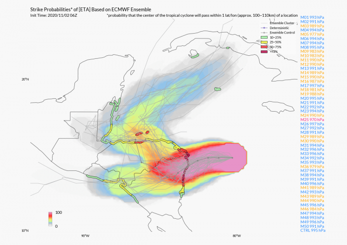
Although Eta’s low-level center may not survive after being inland over Central America for so long, most of the global models depict a large cyclonic circulation over the northwestern Caribbean Sea later this week.
And what are the models now is the general agreement, there is quite high confidence that the remnants of Eta could re-emerge back over the northwest Caribbean Sea the next weekend.
The Western Caribbean region is closely monitored as the weather models continue to forecast additional activity over the Caribbean later on. Both global weather models, ECMWF and GFS, still agree at an increased potential of turning Eta’s remnants north-northeast with the potential track towards Cuba.
Potentially even towards the eastern portions of the Gulf, Florida, or the Bahamas over the next weekend.
With the extremely favorable oceanic waters and high mid-level moisture, the low-shear environmental support, and deep MJO wave underway from the west, development is quite supportive and odds are high.
However, if a more northerly trajectory takes place, that would definitely enhance the concern the system could become a threat for the eastern Gulf Coast and the United States mainland at some point.
That could potentially bring an unprecedented 12th landfall of tropical storm or hurricane this season.
HISTORY OF NOVEMBER HURRICANES
After October’s tropical activity, we are now looking at what could November 2020 brings us with this above-normal Atlantic Hurricane season.
Typically in October and November, more westerly prevailing winds develop across the central and eastern United States. This tends to keep any potential tropical systems away from the western parts of the Gulf of Mexico.
But such steering winds and circulations more likely lead to the formation of the tropical systems over the Caribbean, moving towards the Bahamas and Florida, and further along the East Coast of the United States.
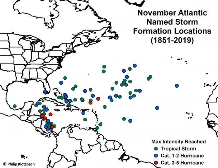
The below map, based on the NHC past data, is showing where Atlantic named storms have formed through the month of November (between 1851 and 2019). It is an obvious sign that all the major hurricanes (Category 3 or greater) have formed in the Western Caribbean.
In 2020, the Western Caribbean region surely greatly fits into these statistics, as Gamma (tropical storm), Delta, Epsilon, and Zeta (all hurricanes) originated in the Caribbean. And now another monster storm has emerged – a major hurricane Eta.
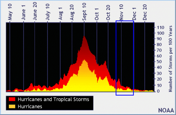
Based on statistics through the years, a typical hurricane season sees the month of November with more quiet month than October. As we can see on the storm frequency graph below from NOAA, November still brings some activity and even destructive hurricanes. The chart is the data averaged through 100+ years, so obviously not every year follows the same pattern.
Late October has a history of some powerful hurricanes, originating from the Caribbean region and moving towards the United States, e.g. Sandy (2012), Wilma (2005), or Mitch (1998).
And also Hurricane Michael made a destructive landfall as a Category 5 hurricane in Florida Panhandle on October 10th, 2018. Michael was the first Category 5 hurricane to strike the United States mainland since Andrew back in 1992.
And indeed Hurricane Delta and Zeta from the Atlantic hurricane season 2020.
Destructive hurricanes in November
November has a history of five Category 4+ hurricanes in the Atlantic basin on record. Lenny (1999), Michelle (2001), Paloma (2008) and Eta (2020) were all Category 4 while Cuba Hurricane (1932) was the only Category 5 November hurricane so far on record.
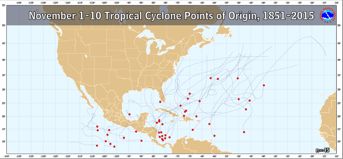
Here is the statistic chart for all the November 1-10th tropical storms formation in the Western Atlantic and the Eastern Pacific. 45 storms formed in this period over the last 164 years. Data are provided by NOAA.
November also has some history of destructive hurricanes, e.g. Paloma (2008), Ida (2009), Otto (2016), and Hurricane Mitch (1998) – it did form in October but dissipated on Nov 9th. Then there was also Hurricane Kate (1985) that hit Florida.
The average trajectory of the tropical systems tracks in October and early November is towards the north and northeast. This puts Cuba, Florida, and the Bahamas at risk of landfall if storms organize over the Caribbean region.
Actually, the month of October is the statistical peak of tropical storm landfalls in Florida. So even early November statistics are not far behind.
So, a typical October/November bring storm tracks closer to land, from the western Caribbean Sea to the eastern Gulf of Mexico, Florida, and also affect the East Coast of the United States.
SEASON ON THE COURSE TO 30+ NAMED STORMS
The current active storm now is Hurricane Eta, the 28th named storm of the 2020 Atlantic hurricane season.
Eta is the seventh (7th) letter of the Greek alphabet. The list was last used in 2005. So we are now past the existing record of 6 names from this list and the Atlantic hurricane season 2020 continues into uncharted territory.
Nevertheless, based on the current statistics, the Atlantic hurricane season 2020 is now tied with the 2005 hurricane season where both had 28 named storms in one season.
For example, the 2005 season had eight (8) additional storms forming in October itself and three (3) storms more forming in November. While 2020 hurricane season had ‘only’ four (4) storms forming in the month of October. Those were Gamma, Delta, Epsilon, and Zeta.
With potentially a few more storms forming through November, we are definitely aiming towards Nu or Xi storm names. That is halfway through the Greek Alphabet names.
There seems to be a fairly high probability that the well-above-average western Atlantic and Caribbean region sea temperatures would be favorable for tropical storm formation even in December this year.
Nevertheless, there is still a long way to go before we will be closing the books of this historic 2020 Atlantic hurricane season.
We will be covering the tropical activity further, providing regular updates on the ongoing activity. The next update is scheduled in the coming days – stay tuned!
Thinking of a nice Christmas gift for your friends, family or someone special to you? Weather calendar could be the perfect gift for them – see below:
