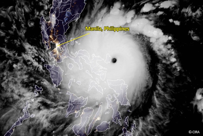
Super Typhoon Goni is now making landfall in the Philippines with catastrophic impacts. The maximum sustained winds have peaked at 195mph (170 knots, 315 km/h) with gusts to 235mph! The landfall is on Catanduanes Island. Typhoon Goni is one of the most powerful tropical systems ever recorded on Earth!
Goni has the maximum sustained winds estimated at 195 mph (170 knots, 315 km/h) with gusts exceeding 235 mph (205 knots, 380 km/h).
The landfall of Super Typhoon Goni could be the strongest landfalling typhoon/hurricane ever recorded on Earth, tied with Meranti and Haiyan.
The minimum central pressure is estimated at 876 mbar!
The latest JTWC advisory has been maintaining the Super Typhoon Goni at a Category 5 strength since Friday, Oct 30th. Right now, Goni is making life-threatening, destructive landfall on Catanduanes Island in the Philippines.
Goni will likely become one of the most powerful tropical cyclone in recorded history to make landfall, it will be even stronger than Super Typhoon Haiyan (Yolanda) which destroyed parts of the Philippines in 2013. Haiyan was one of the deadliest Philippine typhoons on record, killing at least 6.300 people in that country alone.
Typhoon Goni is now also tied with Meranti in 2016 which was, besides Haiyan, the most intense tropical cyclone in the Eastern Hemisphere by 1-minute sustained winds of 195 mph (170 knots).
Catanduanes Island is taking the full brunt of one of the most powerful storms to make landfall. The population of the island is about 250.000. The consequences will be catastrophic and deadly.
The environmental conditions over the region suggest that more storms are increasingly likely over the Western Pacific next week.
EXTREMELY WARM WESTERN PACIFIC OCEAN
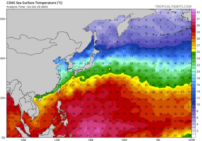
A large part of the Western Pacific remains extremely warm. That is exactly where Super Typhoon Goni (and further storms next week) is tracking. The sea waters are very hot! Sea surface temperatures of 30-31 °C are spread across the Philippine Sea, all the way west of Marianas and the Philippines.
Even warmer, close to 32 °C sea waters are present over the southern portions of the Philippine Sea.
The sea waters are very much above the normal long-term average through late October. Nearly 2 degrees Celsius warmer, even 3 °C above the average in some areas of the Western Pacific tropical region. This means that the oceanic conditions are beyond exceptional and that is why these conditions have helped Typhoon Goni to become a very violent storm.
Goni has been tracking over these extremely favorable, hot oceanic conditions through its whole lifecycle so far.
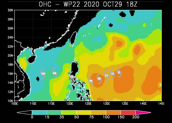
The Ocean Heat Content (OHC) values are very high, above 150. Such high values of the OHC often contribute to an extremely rapid, explosive intensification of tropical systems.
This extremely rapid intensification is exactly what has happened with Typhoon Goni. It has intensified from 35 knots to 155 knots within a 48-hour period (between 12 UTC Wednesday to 12 UTC Friday).
EXCEPTIONAL SATELLITE ANALYSIS
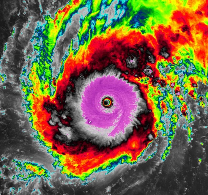
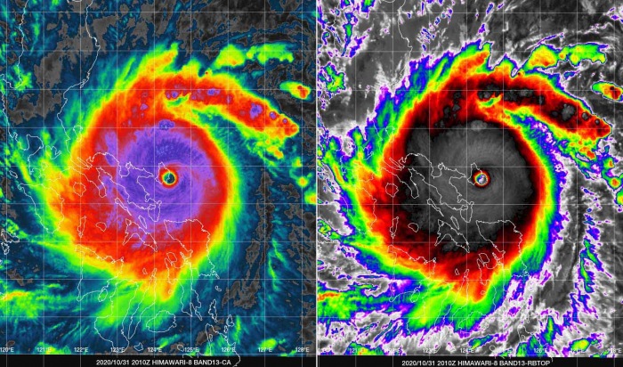
The animated enhanced infrared satellite imagery depicts a compact, dense, and perfectly symmetrical typhoon with a well defined 12 nautical miles diameter eye.
The attached infrared scan below reveals that the cloud tops temperatures are already extremely low, maintaining between -85 and -90 °C all the time! This is a sign that convection is very intense, supporting an extremely violent strength of the typhoon.
There was also a pinhole eye appearing on different satellite channels earlier on Friday, which is a typical sign that an explosive burst of storms is developing a very intense tropical system. On early Saturday, Goni has undergone an Eyewall Replacement Cycle (EWRC) and its eye had double the size after it was completed.
And so were its winds increasing, so it continued strengthening towards the peak intensity of 170 knots (195 mph) until the landfall.
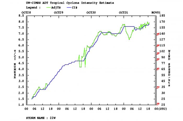
Based on the Dvorak intensity estimate of T8.0 number and is hedged slightly higher than an Advanced Dvorak Technique (ADT) analysis with the current intensity estimate of T7.8 (164 knots).
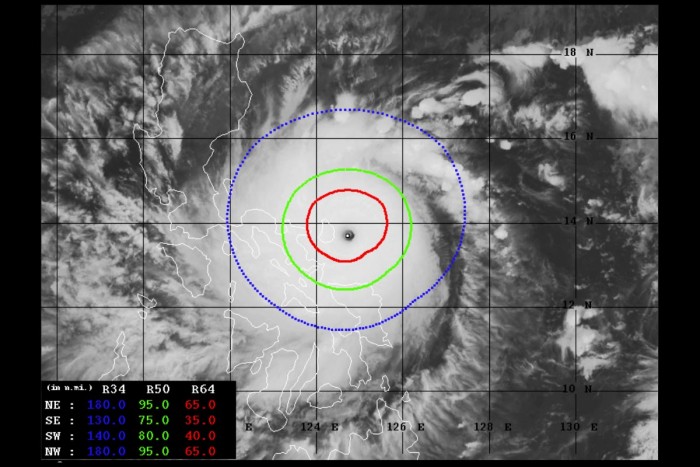
Its tropical-storm-force 50-knot winds are spread across the 80-100 mile radii around the eye. While Goni also has around 40-70 radii of hurricane-force 64-knot winds. The wind field is expanding and strengthening.
We could see that an exceptional intensification was ongoing since its birth as a typhoon three days ago, steadily increasing until Saturday. A temporal shallow weakening is seen on Saturday, during the Eyewall Replacement Cycle.
Both the environmental and oceanic conditions remained extremely conducive for maintaining its powerful strength. Very warm (29-30 degrees Celsius) Philippine sea surface temperatures are present in the area. The radial upper-level outflow is exceptional, with textbook ventilation in all directions, offset by moderate (15-20 knots) vertical wind shear.
DESTRUCTIVE GONI TRACKS ACROSS THE PHILIPPINES
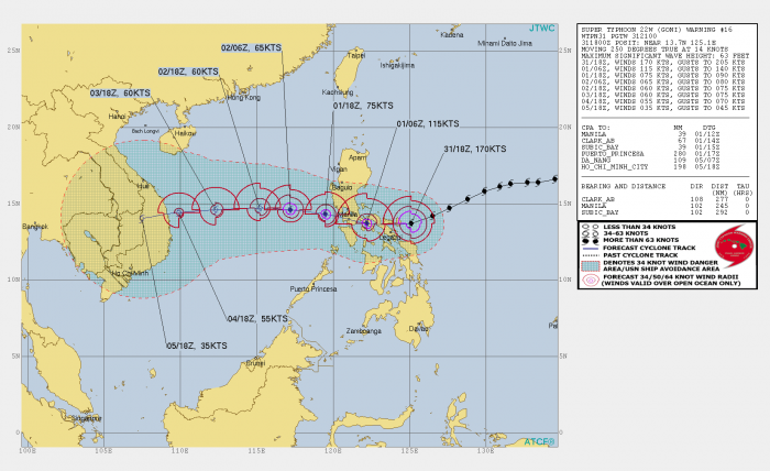
As of the latest JTWC advisory, Super Typhoon Goni was located approximately 245 nautical miles (450 kilometers) east-southeast of Manila, the Philippines, the capital city. Goni has tracked west-southwestward at 14 knots over the past six hours.
Then, Goni has made a life-threatening, destructive landfall on Catanduanes Island in the eastern Philippines.
Super Typhoon Goni continues tracking along the southern periphery of a subtropical ridge to the northwest.
There is no significant change to the forecast track since the previous thinking, Goni is more or less taking the western track now, across the Philippines, and will pass very near the capital Manila over the next 12 hours. The pass will likely include its strongest winds near the center.
The interaction with the underlying terrain across the Philippines will lead to a significant weakening to around 75 knots today (on Sunday). Goni will then enter the very warm waters of the South China Sea where the environmental conditions will become unfavorable for any significant re-intensification.
Goni will, however, remain a typhoon and will track generally westward under the influence of the ridge positioned to the north. The final landfall is likely in central Vietnam through the mid-next week as a 40-60 knots storm.
EXTREME RAINFALL AND STORM SURGE IMPACT LIKELY
Typhoon Goni comes soon after the typhoon Molave which has crossed the central Philippines earlier this week. Molave re-emerged and rapidly intensified over the South China Sea and blasted into Vietnam. It was the 4th storm to hit the nation this month.
What the weather models are simulating is a real concern for the central Philippines and Luzon, Philippines. The path and the landfall of Super Typhoon Goni bring the system with a very powerful impact on the country.
As it seems, the landfall at Catanduanes Island was likely of a destructive Category 5 strength with 170 knots sustained winds.
The impact is destructive and deadly.
An extremely dangerous situation is unfolding and will continue developing over the region while Super Typhoon Goni continues tracking westward. Areas along its path will be severely devastated by violent winds and intense flooding.
The impact of life-threatening storm surge is also imminent right now.
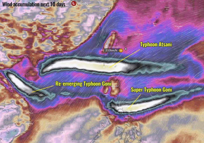
Attached are the wind swaths of the potential tracks and intensities over the next 10 days, per the ECMWF model. It shows a very severe impact of Typhoon Goni in the central Philippines.
We can also see a hint of another, potentially even stronger typhoon forming further north – that is a Tropical Depression 23W, with a designated name Atsani.
We can see that the eastern portions of the Philippines are being affected by extremely intense winds associated with Super Typhoon Goni. This is the European ECMWF model forecast, provided by Windy.com.
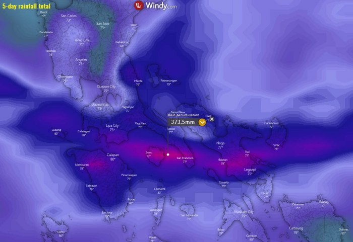
A significant amount of rainfall is likely to be expected across the eastern and central Philippines. The exact amount and area of the strongest rainfall are indeed very hard to forecast, depending on the track and storms around the eye.
Nevertheless, a huge amount of rainfall is likely, given the very hot seas and therefore high moisture available. Graphics are provided by Windy.com.
Typhoon Goni is expected to significantly weaken after its landfall in the Philippines. Then, the weather models are hinting its re-strengthening after it emerges into the South China Sea.
Although it will be moving just a few days after the typhoon Molave, and the environmental conditions seem rather unnfavorable, it may still become a typhoon again and head for another dangerous impact on Vietnam and Cambodia.
MORE STORMS ARE LIKELY TO FOLLOW
As seen in the video animation below, the activity over the Western Pacific is significantly increasing over the next two weeks. At least another strong typhoon – Atsani – is expected. It may be on the way to the Philippines as well or further north towards Taiwan. Its exact track is yet to be defined.
While there are hints of another system possibly following Goni and Atsani later in early November. Yet to be seen on the weather models in the coming days, however.
We are closely monitoring the activity in this tropical region as well and will be covering all these events.
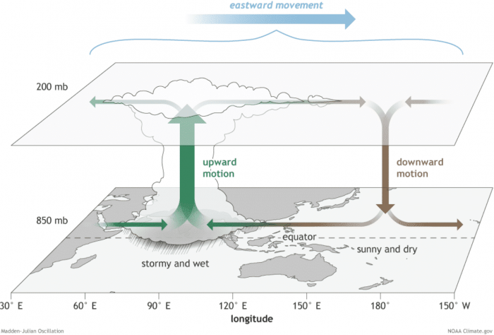
The reason for this re-developing higher activity is a somehow improved upper-level pattern. The western edge of the Madden-Julian Oscillation (MJO wave) traveling east is supporting convective activity within a divergent flow in the higher levels of the atmosphere.
WHAT IS THE MADDEN-JULIAN OSCILLATION?
The Madden-Julian Oscillation (MJO) is the largest and most dominant source of short-term tropical variability, it is an eastward-moving wave of thunderstorms, clouds, rain, winds, and pressure. It circles the entire planet on the equator in about 30 to 60 days.
Through the end of October, a new well-defined wave has moved from the Pacific into the Atlantic tropical region. It will also extend into early November.
The MJO consists of two parts: one is the enhanced rainfall (wet) phase and the other is the suppressed rainfall (dry) phase. This means there are increased storms and rainfall on one side and reduced storms and drier weather on the other side.
The air parcels are diverging (moving away) over the wet phase, and converging (moving together) over the dry phase. This horizontal movement of air is referred to as the Velocity Potential (VP) in the tropics.
We are able to track the entire MJO wave movement by looking at the larger scale air parcels movement. With the weather model data, we can easily see the areas where the air is rising and where it is subsiding.
Another important factor is the Ocean Heat Content (OHC). OHC takes into account the depth of the sea, and how warm the water layers are deep below the sea surface. In this month, we can still see a large pool of high available heat energy with a very warm water layer running down quite deep.
Deepwater being so warm as this season, provides a very favorable environment of a thick layer of warm water. Tropical systems are fueled by these warm layers, as deep convective storms draw energy from hot water.
Long story short: the thicker the warm layers are, the more fuel/energy is available to feed the storms.
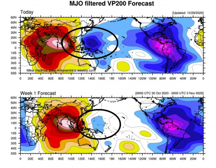
The above graphics, provided by Michael J. Ventrice, Ph.D. represent an MJO wave with filtered VP200* anomalies for the current state and for the week 1 forecast.
Cold colors are representative of a more favorable state (over the Atlantic) for tropical cyclogenesis while warm colors represent a less favorable state for tropical cyclogenesis. We can see that the Western Pacific region also hints at some blueish colors, so conditions remain favorable.
*VP200 – means a Velocity Potential (VP). It is an indicator of the large scale divergent flow, so at upper levels in the tropics. The negative VP anomalies (shaded blue in the diagram) are closely tied to the divergent outflow from enhanced convective regions.
Activity seems to continue into early November, given the very favorable MJO wave pattern seen per week 1.
Typhoon – the strongest storms on Earth
A typhoon is a mature tropical cyclone, forming in the western Pacific (between 100° and 180° East in the Northern Hemisphere). Typhoons are, besides hurricanes, the most powerful tropical weather events on Earth.
The region where typhoons form is known as the Northwestern Pacific Basin. It is the most active tropical cyclone basin on Earth, accounting for almost one-third of the world’s annual tropical cyclones forming.
A tropical cyclone gets designated to a typhoon when maximum sustained winds are above 64 knots (73 mph or 118 km/h). If winds exceed 130 knots (150 mph or 241 km/h), the typhoon is upgraded to a Super typhoon.
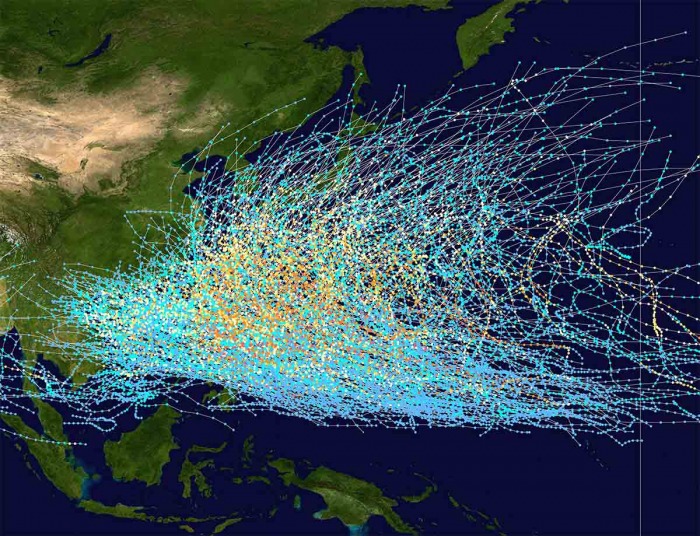
On average, there are more than 26 tropical storms and typhoons every year. These systems have a general westward track towards the Philippines, southern China, Taiwan, and Vietnam.
