Atlantic 2020 hurricane season is now officially an extremely active season – the Accumulated Cyclone Energy (ACE) is above 155! Hurricane Eta made destructive landfall in Nicaragua as a Category 4 storm on Wednesday this week. Eta will now re-emerge over the warm Caribbean Sea and turn towards Cuba and the Florida peninsula. It could become the record-breaking 12th landfall in the United States mainland this season.
November hurricanes have surely been less frequent than during October as the warm ocean waters are already cooling and wind shear is increasing across the Northern Hemisphere. This brings less favorable conditions for tropical development.
However, hurricanes in November do happen, even strong ones. A recent example is definitely Hurricane Eta, which literally exploded into a high-end Category 4 storm over the western Caribbean earlier this week.
The Florida Peninsula has seen no landfalls of tropical storms so far this season, despite a record-setting 2020 Atlantic hurricane season. But this might change in the coming days.
Eta was the 5th major hurricane of the season
Eta was the strongest November Atlantic hurricane since Paloma in 2008.
And it is also the 3rd major hurricane to form in the Atlantic since October 1st, after major hurricanes Delta and Epsilon in October. This is now the first time on record that the Atlantic has had 3 major hurricane formations in October and November.
Eta was a high-end Category 4 hurricane at the landfall in Nicaragua. This was the first since Felix in 2007 (Felix was even stronger, a Category 5 hurricane).
According to dr. Philip Klotzbach, there have only been three (3) Category 4 and one (1) Category 5 hurricane in the Atlantic basin in November on record; Lenny (1999), Michelle (2001), and Paloma (2008) were all Category 4 while Cuba Hurricane (1932) was the only Category 5 November hurricane so far on record.
Extreme rainfall from Eta resulted in catastrophic flash flooding and river flooding across portions of Central America after its landfall on Wednesday. Nicaragua and Honduras were badly hit. Destructive winds and floods caused the loss of life.
And additional flash and river flooding threats remain across Jamaica, southeast Mexico, the Cayman Islands, and western Cuba until late Friday.
Eta re-emerging over the Caribbean and heads towards Cuba and Florida
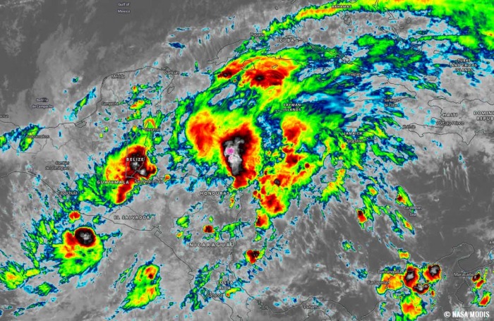
A deep MJO wave is underway over the Caribbean region and the Tropical Atlantic, leading to increasing thunderstorm activity and favorable for tropical activity.
During the late season (October and November), a tropical activity gradually shifts into the Caribbean region, which has been experiencing much above normal sea temperatures this year. Extremely warm sea temperatures are also spread deeper into the ocean waters.
Eta has weakened while traveling across Nicaragua and Honduras and its remnants are now ejecting into the northwestern Caribbean Sea again. It is expected to re-develop into a Tropical Storm again on Friday.
A Tropical Storm Watch has already been issued for the Cayman Islands while a Tropical Storm Watch will likely be required for portions of Cuba later tonight or on Friday.
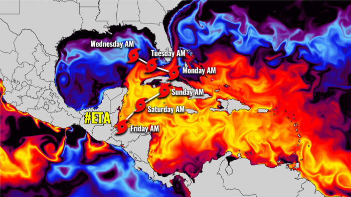
The exact details of Eta’s future track and intensity are still uncertain, but there is an increased risk of impacts from severe wind and heavy rainfall in portions of the Cayman Islands, Cuba, southern Florida, and the Florida Keys this weekend into early next week.
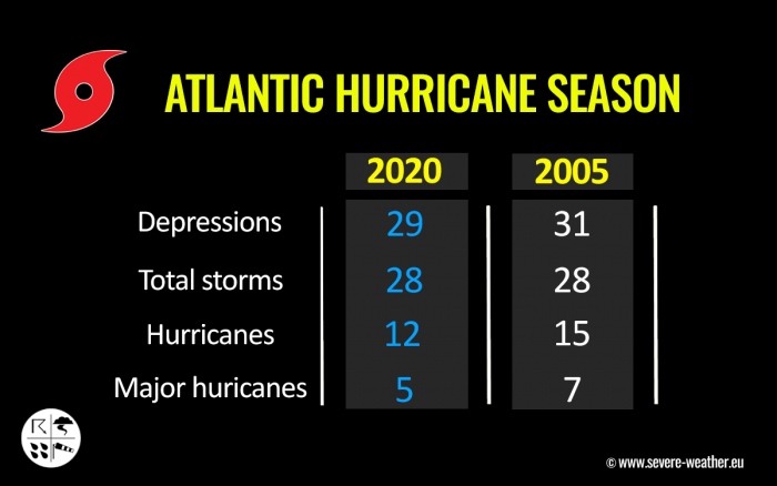
The 2020 hurricane season is now tied with the 2005 season as both had 28 named storm formations. Both years were the only ones that the Greek alphabet was in use.
So with Eta being the 7th letter from the Greek alphabet list, the 2020 Atlantic Hurricane season is now digging deeper into the list and writing the history books.
STORM NAMES DIG INTO UNCHARTED GREEK ALPHABETS
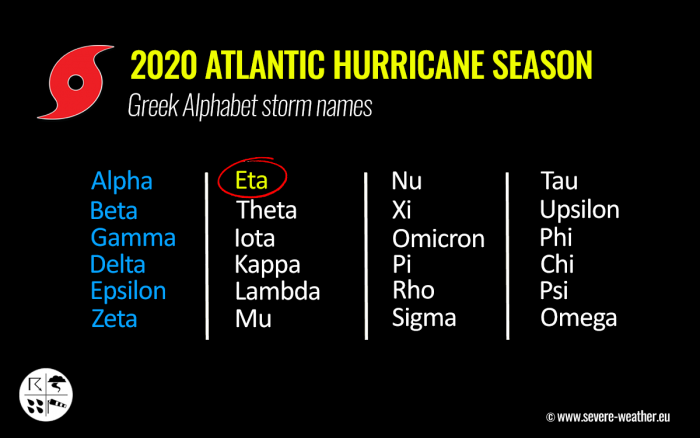
As soon as Hurricane Eta formed, this was the seventh (7th) letter of the Greek alphabet. This means that the Atlantic Hurricane season is now beyond the existing record of 6 names from this list used in 2005.
Storm names are now digging into uncharted territory, so we are facing unprecedented times for the named storms for any Atlantic hurricane season on record.
The environmental conditions across the Caribbean Sea are very conducive for further development, as a strong and deep MJO wave is now supporting upper-level divergence over the region.
The 2020 Atlantic Hurricane Season ends at the end of November, while the most active years have seen storms forming also in the off-season in December before.
The 2020 hurricane season is now very likely on the way for a new record for the most named storms in one season. Past 28 named storms from 2005. Also remember that the 2005 Atlantic hurricane season churned out powerful hurricanes like Katrina, Rita, and Wilma.
Although the intensity of the 2020 hurricane season might not be as strong as the 2005 season (yet), we are still facing the fact, that this year could generate even more than 30 named storms in total for the season.
2020 ATLANTIC HURRICANE SEASON SO FAR
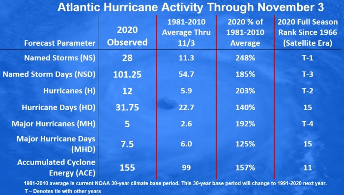
The 2020 Atlantic hurricane season remains on course for a record-setting year to date, Nov 3nd. There were 28 named storms, which is about 248 % of the long-term average (11.3) for this time period. So far, there were more than double the number of hurricanes (12) and five (5) major hurricanes (Laura, Teddy, Delta, and Zeta).
Hurricane Eta was the 5th major hurricane of the season.
26 storms out of those 28 total, had the earliest formation date on record.
Major hurricanes Laura, Teddy, and Delta have all peaked at Category 4 strength. Laura and Delta both made destructive landfalls in Louisiana.
The southern parts of Louisiana along the central Gulf Coast of the United States, were a hot spot this year. There have been 5 storms that made landfall in Louisiana. 3 of those five were hurricane landfalls (Laura, Delta, and Zeta).
Laura made landfall as a Category 4, while Delta and Zeta were a Category 2 when they came ashore in Louisiana. Laura and Delta affected the same areas with severe wind and storm surge damage. Zeta made landfall further east, due south of New Orleans.
There have been 101 named storm days so far, which is around 185 % of the average number (54.7). As we can see from the statistical graphics above (see the column 2nd from the right), all the forecast parameters are above average.
Including hurricane days (31.8), major hurricanes (5), and major hurricane days (7.5). Provided graphics are by Dr. Philip Klotzbach.
The Atlantic, Caribbean region, the Gulf of Mexico, and the East Coast of the United States were also the most active tropical regions globally this year.
Accumulated Cyclone Energy (ACE index)
The Accumulated Cyclone Energy is the energy output of a hurricane season, calculated as an index (ACE index). It is a metric used to express the energy used by a tropical cyclone during its lifetime.
The index calculation takes the cyclone’s maximum sustained winds every six hours and multiplies it by itself to generate the values. The total sum of these values is calculated to get the total for a storm.
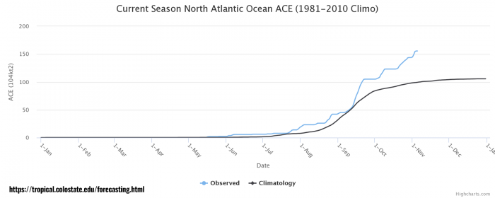
The current Atlantic basin ACE is, as of November 3rd, held at 155.0. That is an impressive 57 percent higher than during a normal season to this date (99.0).
With the ACE above the threshold 152.5, this means that the 2020 Atlantic hurricane season is now officially an extremely active season. However, there is still a long run to reach the strongest Atlantic hurricane season like 1933 (ACE of 258.6), 2005 (250.1), or 1893 (231.2).
The highest ACE so far this season was generated by Teddy (27.8), Paulette (15.9), Delta (15.7), Epsilon (13.1), Laura (12.8). The current system – hurricane Eta – added another 11.8 to the ACE index total for the Atlantic 2020 hurricane season so far. But the number is not final yet as Eta will re-emerge over the Caribbean again.
Record-breaking 11 landfalls in the United States mainland
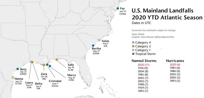
There are even more remarkable statistics. The 2020 Atlantic hurricane season has had a record-breaking 11 landfalls of tropical storms (or hurricanes) in the United States mainland this season.
Hurricane Delta and Zeta have helped the season to break the previous record of nine landfalling systems more than 100 years ago – in 1916.
Hurricane Delta was the first hurricane named after a Greek alphabet letter use which made landfall on the United States mainland.
The eleven (11) named storms that made landfall in the continental United States this year (2020) so far are Bertha, Cristobal, Fay, Hanna, Isaias, Laura, Marco, Sally, Beta, Delta, and Zeta.
And to make it even greater, there were six (6) hurricane landfall out of those 11 named storms landfall in the United States mainland. This ties with the 6 hurricane landfalls in one full season (1985 and 1886).
The Atlantic 2020 hurricane season has also tied another record – there were 3 tropical storm formations on September 18th. Tropical Storm Wilfred, Subtropical Storm Alpha, and Tropical Storm Beta formed in a single day which has happened only once before (1933).
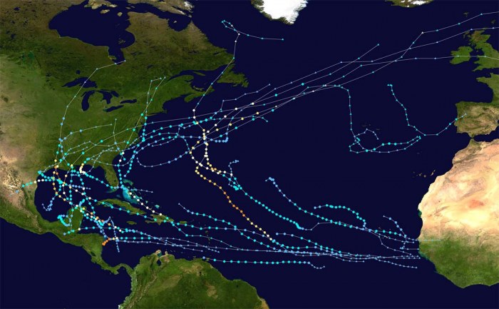
The graphics above show all the tropical storm tracks for the 2020 Atlantic Hurricane season so far. The image is provided by Wikipedia, based on the official data from the National Hurricane Center (NHC).
DESTRUCTIVE LANDFALL OF ETA IN NICARAGUA
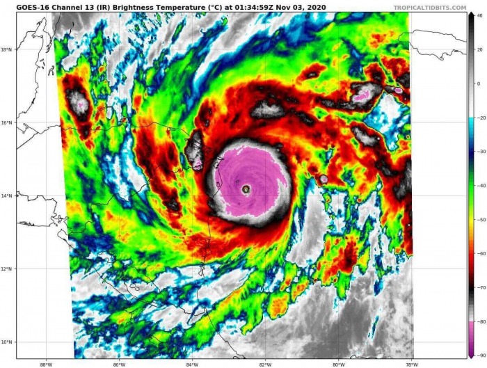
According to the National Hurricane Center (NHC), hurricane Eta was a destructive high-end Category 4 hurricane when it made landfall on Wednesday.
The vulnerable coast of northeast Nicaragua was badly hit. Extreme rainfall (500-800 mm = 20-30 inches) caused destructive flash floods, landslides, and structural damage and lead to loss of life.
At least five fatalities have been reported across Nicaragua and Honduras, from mudslides caused by flash floods. Although the violent winds have soon vanished after the landfall, destructive winds spread extensive damage across the city of Puerto Cabezas in northeastern Nicaragua. A city with a population near 60.000.
Prior to landfall, hurricane Eta has been very rapidly strengthening and became the 5th major hurricane of the 2020 Atlantic hurricane season. The sustained winds have increased from 50 knots to 115 knots over the 24 hours period through Tuesday and Wednesday – a 65 knots (75 mph) increase!
After the landfall, Eta has continued west into Honduras while weakening. And its center has reached the northwestern coast of the country by Thursday afternoon.
Eta is now slowly emerging back into the northwestern Caribbean.
WESTERN CARIBBEAN SEA REMAINS HOT
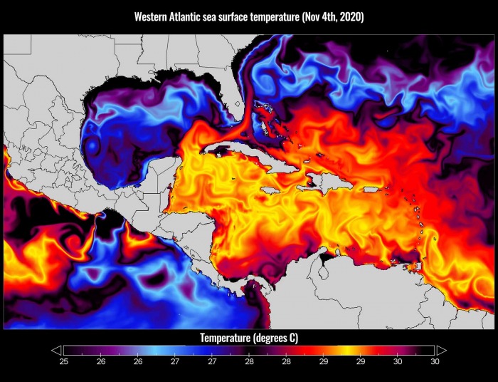
The sea surface temperatures remain very warm in the Western Atlantic, and extremely warm over the Caribbean region.
The sea surface temperatures are reaching close to 30 °C (86 °F). Especially across the northwestern Caribbean Sea, around Cuba and Jamaica. Even hotter temperatures are seen across the southern portions of the Caribbean.
Those are definitely prime oceanic conditions as sea waters remain much higher than the long-term average. So the upcoming re-development of Eta’s remnants will have the most important ingredient ready.
Therefore, such conditions are strongly supportive of rapid or even explosive development of thunderstorms. Just like hurricane Eta did this week, entered an extremely rapid intensification phase when moving towards the central American coast.
The majority of the North Atlantic, tropical Atlantic, and the Caribbean remain well-above average. The Eastern Pacific is also very hot, past 30 °C and therefore several degrees above normal. About 1-2 °C warmer sea waters are also across the Northwest Atlantic.
Although waters are slightly cooler over the Gulf of Mexico, there are still warm waters across the eastern portions of the Gulf and around Florida, including the Bahamas, and along the East Coast of the United States.
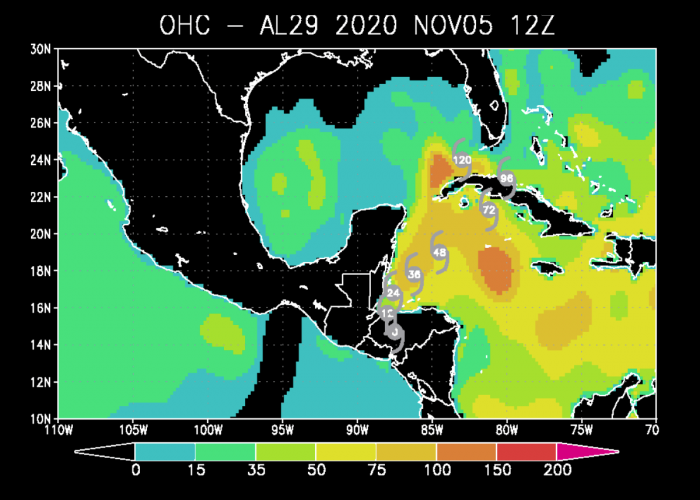
As can be seen from the Ocean Heat Content (OHC) map above, the values are quite high (near or even higher than 100) across the northwestern Caribbean and around western Cuba (southeastern Gulf of Mexico).
This is exactly where the re-emerging storm/hurricane Eta is about to travel in the coming days. The system should strengthen while traveling over these warm waters, it could even rapidly intensify and reach hurricane strength again.
ETA WILL FIRST CROSS CUBA
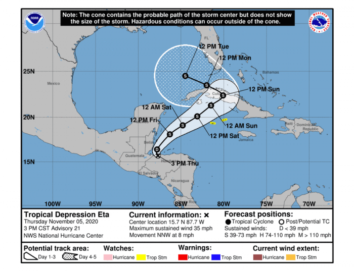
According to the National Hurricane Center (NHC) on Thursday, the low-level circulation of Eta has become disorganized to the point that the system more resembles a remnant low than a tropical cyclone. However, the system continues to produce convection across the broad circulation.
The system will start re-developing through Thursday night as it moves back over warm waters of the northwestern Caribbean.
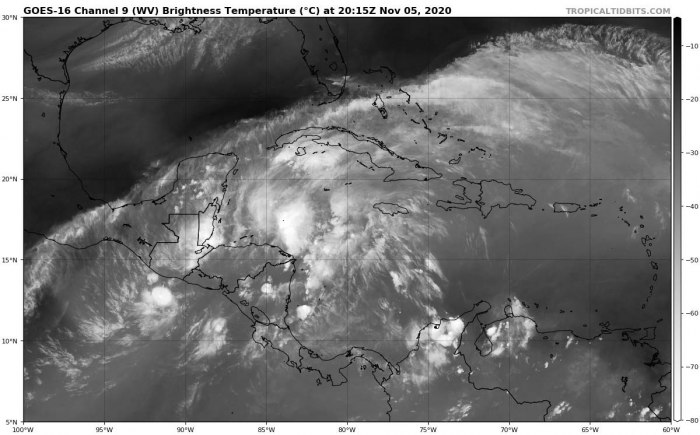
The water vapor satellite reveal the moisture across the Caribbean is quite high, and the shear is low. This should allow Eta to begin organizing again over the region.
Eta will likely be upgraded back to a Tropical storm on Friday as it moves closer to Cayman Islands. It will be rather slow-moving further towards the northeast and cross western Cuba this weekend.
There are possibilities that the system could also become a hurricane prior to landfall in Cuba, some models suggest.
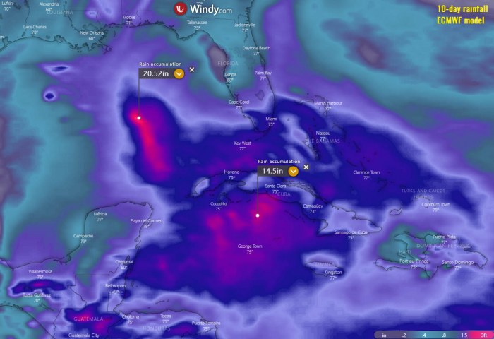
The amount of rainfall (map provided by Windy.com) should be the highest concern for Cuba. Attached is the ECMWF model chart for the next 10-days rainfall totals. Close to 15 inches (400 mm) seems possible between the Cayman Islands and Cuba, possibly even more.
But as the exact locations of storm clusters are hard to predict, locals have to monitor Eta’s progress closely. Life-threatening flash floods could occur in some areas.
ETA COULD THEN HEAD FOR FLORIDA
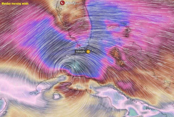
After Sunday, Eta will begin turning more north and then northwest and travel towards Florida and the Florida Keys. The exact track remains uncertain so far in advance, but people in southern Florida and the southwestern Bahamas should closely monitor the progress of Eta.
The map above is provided by Windy.com.
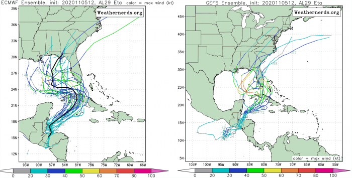
The comparison of both global models, ECMWF and GFS, ensemble forecast hints that Eta will indeed cross western Cuba first and then turn towards the mainland United States.
The exact track is rather unknown, however. Eta might travel towards landfall in southern Florida with the most likely scenario being its heading towards northwest into the Gulf.
But non-zero chances also exist that Eta would head for landfall in southeast Florida and cross the peninsula while moving west.
Although the landfall in Florida or the Florida Keys is not yet warranted, it is certainly a possibility. Ensemble perturbations also hint that areas further north along the Florida peninsula have to monitor Eta’s progress very closely.
About 5-10 inches of rain will be possible across southern Florida and the western Bahamas through Tuesday, regardless of the track of Eta’s center.
If Eta does make landfall in Florida (the Florida Keys or further north along the peninsula), that would bring an unprecedented 12th landfall of a tropical storm or hurricane on the United States mainland in the 2020 Atlantic hurricane season.
HISTORY OF NOVEMBER HURRICANES
After October’s tropical activity, we are now looking at what could November 2020 brings us with this above-normal Atlantic Hurricane season.
Typically in October and November, more westerly prevailing winds develop across the central and eastern United States. This tends to keep any potential tropical systems away from the western parts of the Gulf of Mexico.
But such steering winds and circulations more likely lead to the formation of the tropical systems over the Caribbean, moving towards the Bahamas and Florida, and further along the East Coast of the United States.
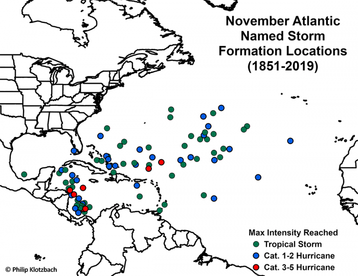
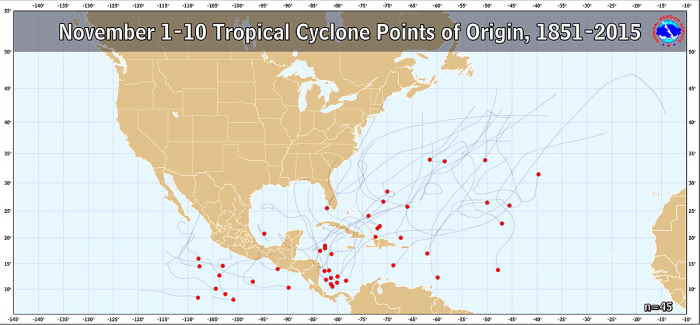
The below map, based on the NHC past data, is showing where Atlantic named storms have formed through the month of November (between 1851 and 2019). It is an obvious sign that all the major hurricanes (Category 3 or greater) have formed in the Western Caribbean.
Based on NOAA statistics, 47 hurricanes have formed in November months but only five of them made landfall in the United States. So odds for a hurricane landfall in November are quite low, but not zero!
In 2020, the Western Caribbean region surely greatly fits into these October and November statistics, as for example Gamma (tropical storm), Delta, Epsilon, Zeta, and Eta (all hurricanes) originated from the Caribbean Sea.
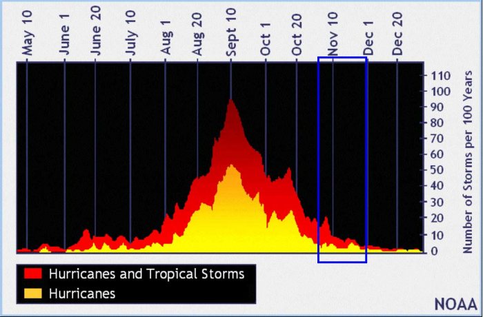
Based on statistics through the years, a typical hurricane season the month of November is a much quieter month than October. As we can see on the storm frequency graph below from NOAA, November still brings some activity and even destructive hurricanes.
The chart is the data averaged through 100+ years, so obviously not every year follows the same pattern.
October has a history of some destructive hurricanes, originating from the Caribbean region and moving towards the United States, e.g. Sandy (2012), Wilma (2005), Mitch (1998).
Or Michael (2018) which made a destructive landfall as a Category 5 hurricane in Florida Panhandle on October 10th, 2018. It was the first Category 5 hurricane to strike the United States mainland since Andrew back in 1992.
And indeed Hurricane Delta and Zeta from the Atlantic hurricane season 2020.
DESTRUCTIVE HURRICANES IN NOVEMBER
But November also has a history of five Category 4+ hurricanes in the Atlantic basin on record. Lenny (1999), Michelle (2001), Paloma (2008), and Eta (2020) were all Category 4 hurricanes.
The only Category 5 November hurricane on record was Cuba Hurricane (1932) so far.
Here is the statistic chart for all the November 1-10th tropical storms formation in the Western Atlantic and the Eastern Pacific. 45 named storms formed in this period over the last 164 years. Data are provided by NOAA.
November also has some history of destructive hurricanes, e.g. Otto (2016), Ida (2009), Paloma (2008), Lenny (1999), Mitch (1998), or Kate (1985).
Hurricane Kate (1985) hit Mexico Beach, Florida on November 21st. It remains the strongest and the latest hurricane on record that hit the mainland United States in the month of November.
The average trajectory of the tropical systems tracks in October and early November is towards the north and northeast. This puts Cuba, Florida, and the Bahamas at risk of landfall if storms organize over the Caribbean region.
Actually, the month of October is the statistical peak of tropical storm landfalls in Florida. So even November statistics are not far behind and landfall in Florida or the eastern Gulf Coast of the United States is possible.
A typical October/November bring storm tracks closer to land and may eventually also affect the East Coast of the United States.
SEASON SHOULD SET A RECORD FOR NAMED STORMS
Eta is the 28th named storm of the 2020 Atlantic hurricane season. It is the seventh (7th) storm from the Greek alphabet list. The list was last used in 2005. So we are now past the existing record of 6 named storms from this list and the 2020 Atlantic hurricane season continues into uncharted territory.
Nevertheless, based on the current statistics, the hurricane season 2020 is now tied with the 2005 hurricane season where both had 28 named storms in one season.
The 2005 season had eight (8) storms forming in October while the 2020 hurricane season had ‘only’ four (4) storms forming. Those were Gamma, Delta, Epsilon, and Zeta.
2005 had three (3) additional storms more forming in November, while 2020 is currently at one storm formation (Eta formed on Nov 1st).
With potentially a few more storms forming through November, we are definitely aiming towards Nu or Xi storm names. That would be halfway through the Greek Alphabet names.
There seems to be a fairly high chance that the well-above-average western Atlantic and Caribbean region sea temperatures would be favorable for tropical storm formation even in December this year.
Nevertheless, there is still a long way to go before we will be closing the books of this historic 2020 Atlantic hurricane season. Officially almost a month, possibly even more if December indeed produces more storms.
We will be covering the tropical activity further, providing regular updates on the ongoing activity. Stay tuned!
Thinking of a nice Christmas gift for your friends, family or someone special to you? Weather calendar could be the perfect gift for them – see below:
