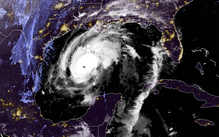
Hurricane Delta has made landfall in the Yucatan peninsula on Monday night. Zeta is now explosively re-strengthening over the warm Gulf of Mexico. NOAA Hurricane Hunters and satellite data suggest that rather rapid intensification is underway. Zeta is expected to bring a potentially dangerous and life-threatening landfall near New Orleans, Lousiana on late Wednesday.
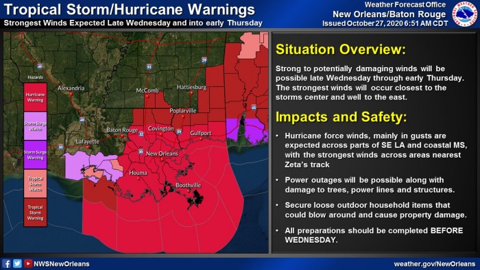
A Hurricane Warning is in effect for the coastal areas of southern Louisiana, Mississippi, and Louisiana.
Hurricane Zeta has made landfall in the Mexican state of Quintana Roo as a Category 1 hurricane last night, Oct 26th.
This set a new record as it was the 3rd named storm to make landfall in Quintana Roo this month (Gamma and Delta were the other two). The previous record for October Quintana Roo named storm landfalls was two, set in 1887 and 2005.
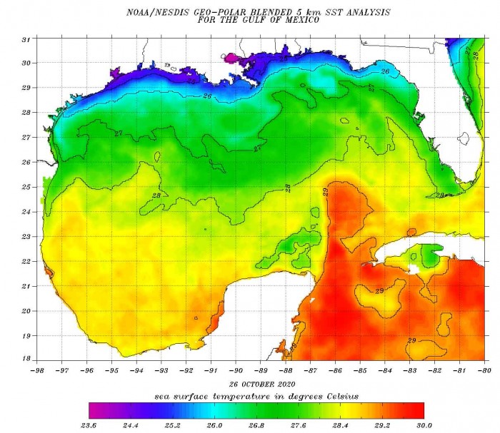
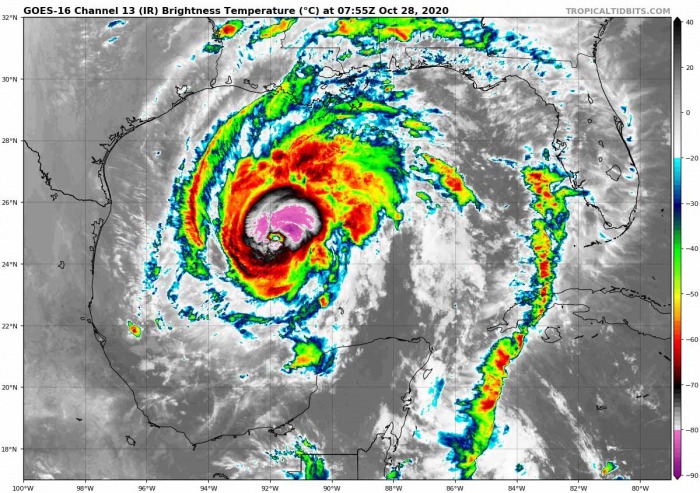
Now, Zeta is re-emerging into the Gulf of Mexico and rapidly strengthening again over the warm waters of the Gulf of Mexico. Explosive storms are visible near the core, a sign that warm waters are taking in effect and boosting Zeta’s intensity.
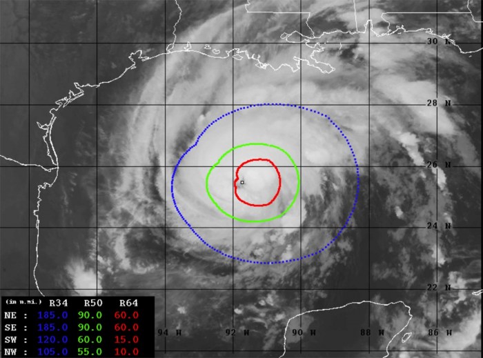
The latest Advanced Dvorak Technique (ADT) estimates are indicating that Zeta is becoming a very powerful hurricane. The maximum sustained winds have increased to near 95 knots (110 mph) with central pressure around 960 mbar. Its tropical-storm-force 50-knot winds are spread across the 60-90 mile radii around the eye.
While Hurricane Zeta also has 20-60 radii of hurricane-force 64-knot winds. The wind field is growing and will soon start affecting the Louisiana coast this early Wednesday morning.¨Zeta is now likely a Category 2 hurricane already.
Zeta has been explosively intensifying over the past 6-9 hours and the winds have, based on Dvorak analysis, increased from 50 to 95 knots!
Zeta is the 6th Greek alphabet named storm of Atlantic hurricane season 2020.
Greek alphabet storm names
Zeta uses the sixth letter of the Greek alphabet that was last used in 2005. The only other year that the Greek alphabet was in use. Now, any additional storm names will go into uncharted territory, so we will be dealing with unprecedented records.
The environmental conditions across the Caribbean Sea are very conducive for further development, as a strong MJO wave is now supporting upper-level divergence over the region.
The 2020 Atlantic Hurricane Season ends at the end of November, while the most active years have seen storms forming also in the off-season in December before.
2020 hurricane season is very likely to generate more than 30 named storms in one season.
HURRICANE SEASON 2020 SO FAR
The Atlantic hurricane season has been a record-setting for named storms to date, Oct 26th. There were 27 named storms, which is about 250 % of the long-term average (10.8) for this time period. So far, there were almost double the number of hurricanes (11) and four major hurricanes (Laura, Teddy, Delta, and Epsilon).
25 storms out of those 27 total, had the earliest formation date on record.
Major hurricanes Laura, Teddy, and Delta have all peaked at Category 4 strength. Major hurricane Epsilon peaked at Category 3 strength while passing near Bermuda on Wednesday, Oct 21st.
Laura and Delta both made destructive landfalls in Louisiana. And what weather models are now hinting with the Hurricane Zeta, it could be a hurricane-strength landfall in the central Gulf Coast of the United States – there are quite high probabilities that the landfall will occur in Louisiana. Again.
The Atlantic, Caribbean region, the Gulf of Mexico, and the East Coast of the United States were also the most active tropical regions globally this year.
There have been 95.5 named storm days, which is around 180 % of the average number (53.0). Other forecast parameters, including hurricane days, major hurricanes, and major hurricane days are also much above the average.
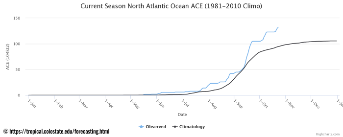
Accumulated Cyclone Energy (ACE index)
The Accumulated Cyclone Energy is the energy output of a hurricane season, calculated as an index (ACE index). It is a metric used to express the energy used by a tropical cyclone during its lifetime.
The index calculation takes the cyclone’s maximum sustained winds every six hours and multiplies it by itself to generate the values. The total sum of these values is calculated to get the total for a storm.
The current Atlantic basin ACE is, as of October 27th, held at 140.1. That is 45 percent higher than during a normal season to this date (96.4).
The highest ACE so far this season was generated by Teddy (27.8), Paulette (15.9), Delta (15.7), Epsilon (13.1), and Laura (12.8).
LIFE-THREATENING LANDFALL IN LOUISIANA
Hurricane Zena will head towards another dangerous landfall at the central Gulf Coast of the United States late today (Wednesday). The potential landfall is expected near Houma, the city close to Morgan City, on a late afternoon/early evening.
Hurricane Zeta will do almost the same as hurricane Delta did two weeks ago. Delta made landfall near Cancun, Mexico, and crossed the northern tip of the Yucatan peninsula. Then, it made its second landfall in Louisiana a few days later.
There is also a rising potential that Hurricane Zeta could even reach Category 2 strength, according to some models. Therefore, reaching the maximum sustained winds around 100 mph. The potential definitely is there given its track over very warm waters until tonight.
According to the National Hurricane Center (NHC), there is a life-threatening storm surge is expected along portions of the northern Gulf Coast by late Wednesday, with the highest inundation occurring somewhere between the Mouth of the Pearl River and Dauphin Island, Alabama.
Attached is the video animation of sea level pressure, precipitation, and wind gusts across the Gulf of Mexico and the Southeast United States. Zeta could become a strong hurricane again. Graphics are provided by the NAM model from Wxcharts.com.
Residents in the Storm Surge Warning area should follow any advice given by local officials.
Zeta is expected to re-intensify over the southern Gulf of Mexico tonight as its structure comes over the still-warm Gulf of Mexico completely. There are still close to 29 °C seawater temperatures across the southern portions of the Gulf, gradually cooler towards the Gulf Coast of the United States.
A Hurricane Warning is in effect for the coastal areas of southern Louisiana, Mississippi, and Louisiana.
Hurricane conditions are expected by late Wednesday within portions of the Hurricane Warning area between Morgan City, Louisiana, and the Mississippi/Alabama border.
Damaging winds, especially in gusts, will spread well inland across portions of southeast Mississippi and southern Alabama Wednesday night due to Zeta’s fast forward speed.
Tropical storm conditions will continue in portions of the northern Yucatan Peninsula of Mexico during the next few hours. Heavy rainfall is expected across the Yucatan Peninsula, the Cayman Islands, and western Cuba today, which will lead to flash flooding in urban areas.
Zeta is forecast to be near hurricane strength again prior to making landfall tomorrow (Wednesday) along the northern Gulf Coast. Potentially in southern Louisiana, very near New Orleans.
If Zeta indeed makes landfall as a hurricane, it would be the latest calendar year hurricane to hit the continental United States since Hurricane Kate in 1985.
And also it bit set a new record as the 11th landfall of a tropical system in the United States mainland. The previous record was 9 named storms in one season.
Hurricane Zeta will bring a lot of rain along its path across the Gulf and across the southeast United States. 5 to 10 inches (125-250 mm) will be possible across southern Louisiana, including the city of New Orleans.
Between tonight and Thursday, heavy rainfall is expected from portions of the central U.S. Gulf Coast into the Ohio Valley and the Mid-Atlantic States near and in advance of Zeta. This rainfall will lead to flash, an urban, small stream, and minor river flooding.
After the landfall, Zeta will begin rapidly weakening while moving inland across the lower Mississippi valley. It will be moving very fast towards the northeast and its remnants will already reach the East Coast of the United States on Friday.
HURRICANE SEASON IS NOT OVER YET
The official hurricane season for the Atlantic Basin (the Atlantic Ocean, the Caribbean Sea, and the Gulf of Mexico) is from June 1st to November 30th. The peak of the season is from mid-August to late October.
By October 27th, the 2020 hurricane season now still has about 35 days left until we close the books at the end of the season.
At the beginning of the hurricane season, NOAA, TWC, and NCSU forecasters predicted: “There will be 13 to 22 named tropical storms in 2020, where 6-9 of those would reach hurricane strength, and 3-4 of them attaining major strength.” The official name list had 23 names reserved this year.
As of Sept 18th, the list usage has been completed as all the reserved names were already used by that date. Since then, the Greek alphabet list is in use.
And we are now already at the 6th Greek alphabet letter, while additional letters are very likely to be used in the following weeks.
After Zeta, the 27th storm of the season, any additional storm names will head into an uncharted area past the existing record of 6 Greek alphabets used in 2005.
Tropical Storm Zeta was the last storm name that was designated by the National Hurricane Center in 2005, the only year using the Greek alphabet prior to the 2020 Atlantic hurricane season.
MADDEN-JULIAN OSCILLATION (MJO)
The Madden-Julian Oscillation (MJO) is the largest and most dominant source of short-term tropical variability, it is an eastward-moving wave of thunderstorms, clouds, rain, winds, and pressure. It circles the entire planet on the equator in about 30 to 60 days.
At the end of October, a new wave will re-emerge from the eastern Pacific into the Caribbean region. It will also extend into early November.
The MJO consists of two parts: one is the enhanced rainfall (wet) phase and the other is the suppressed rainfall (dry) phase. This means there are increased storms and rainfall on one side and reduced storms and drier weather on the other side.
The air parcels are diverging (moving away) over the wet phase, and converging (moving together) over the dry phase. This horizontal movement of air is referred to as the Velocity Potential (VP) in the tropics.
We are able to track the entire MJO wave movement by looking at the larger scale air parcels movement. With the weather model data, we can easily see the areas where the air is rising and where it is subsiding.
Another important factor is the Ocean Heat Content (OHC). OHC takes into account the depth of the sea, and how warm the water layers are deep below the sea surface. In this month, we can still see a large pool of high available heat energy with a very warm water layer running down quite deep.
Deepwater being so warm as this season, provides a very favorable environment of a thick layer of warm water. Tropical systems are fueled by these warm layers, as deep convective storms draw energy from hot water.
Long story short: the thicker the warm layers are, the more fuel/energy is available to feed the storms.
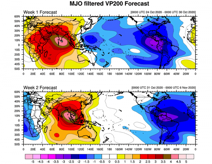
The above graphics, provided by Michael J. Ventrice, Ph.D. represent an MJO wave with filtered VP200* anomalies for the current state, for the week 1 forecast, and for the week 2 forecast. Cold colors are representative of a more favorable state over the Atlantic for tropical cyclogenesis while warm colors represent a less favorable state for tropical cyclogenesis.
*VP200 – means a Velocity Potential (VP). It is an indicator of the large scale divergent flow, so at upper levels in the tropics. The negative VP anomalies (shaded blue in the diagram) are closely tied to the divergent outflow from enhanced convective regions.
It is an obvious sign that during the week 1 forecast (end of October), the MJO wave will emerge into the Caribbean region, lowering the pressure and providing a strong boost to thunderstorm activity.
Activity seems to continue into early November, given the very favorable MJO wave pattern seen per week 2.
MORE THAN 30 NAMED STORMS IN 2020?
Hurricane Zeta is the 27th named storm of the 2020 Atlantic hurricane season and it is the 6th letter from the Greek alphabet.
Additional storm names will head into an uncharted area past the existing record of 6 Greek alphabets used in 2005. Tropical Storm Zeta was the last storm name that was designated by the National Hurricane Center in 2005, the only year using the Greek alphabet prior to the 2020 hurricane season.
Based on the current statistics, the Atlantic hurricane season 2020 is only one system away from the record of 28 named storms in 2005.
For example, the 2005 season had eight (8) additional storms forming in October itself and three storms more forming in November. Tropical Storm Zeta has formed after the official end of the hurricane season in the central Atlantic Ocean on December 30th.
There is quite a high potential that a few more storms could form in November, so we are definitely aiming towards Nu or Xi storm names. That is about halfway through the Greek Alphabet names.
The bottom line, it seems to be a fairly high probability that the well-above-average western Atlantic and Caribbean region sea temperatures would be favorable for tropical storm formation even in December this year.
Nevertheless, there is still a long way to go before we will be closing the books of this historic 2020 Atlantic hurricane season.
DON’T MISS:
