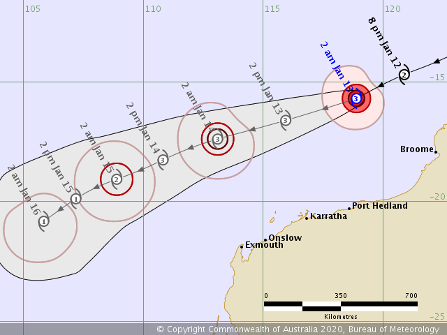
Tropical Cyclone #Claudia is now a solid Category 3 tropical system, officially a Severe Tropical Cyclone with maximum sustained winds of 70 knots / 80 mph / 130 km/h and central pressure below 970 mbar. It continues strengthening while moving west to the immediate north of the coastal Western Australia state. Models are hinting it may even reach a Category 4 within the next 24 hours, JTWC forecast suggests 90 knots by 18 UTC tomorrow, Jan 13th. However, despite Claudia being severe cyclone, it will stay away from the Australian continent over the next days.
*********************************************
*********************************************
Satellite imagery reveals a quite impressive explosive deep convection gradually forming a broad circulation around the center low, cloud tops are constantly below -80 °C. There is an improving upper-level outflow ventilation, supporting further strengthening of the cyclone.
https://twitter.com/HurricaneiOS/status/1216459372810981376
Latest satellite image of Category 2 Tropical Cyclone #Claudia at sunset from @zoom_earth #CycloneClaudia pic.twitter.com/YtZXNmXQro
— Zoom Earth (@zoom_earth) January 12, 2020
The future movement of Severe Tropical Cyclone Claudia remains on track with the previous model guidance, drifting it further west-southwest while gradually gaining strength. While Claudia has already reached a Category 3 strength today, which is one category stonger than previous thinking, it is quite possible it may eventually reach a Category 4 within the next 24-36 hours! ECMWF model is simulating peak gusts may reach up to around 200 km/h:
We will continue monitoring Claudia’s evolution – stay tuned!
See previous discussions regarding Claudia:
Meawhile a monster extra-tropical cyclone delivers up to 200 km/h towards western Europe:
See also – an eruption of Taal volcano in Philippines:
Interested in our calendar? We are proud to present and promote the best weather photographers in Europe – see details:


