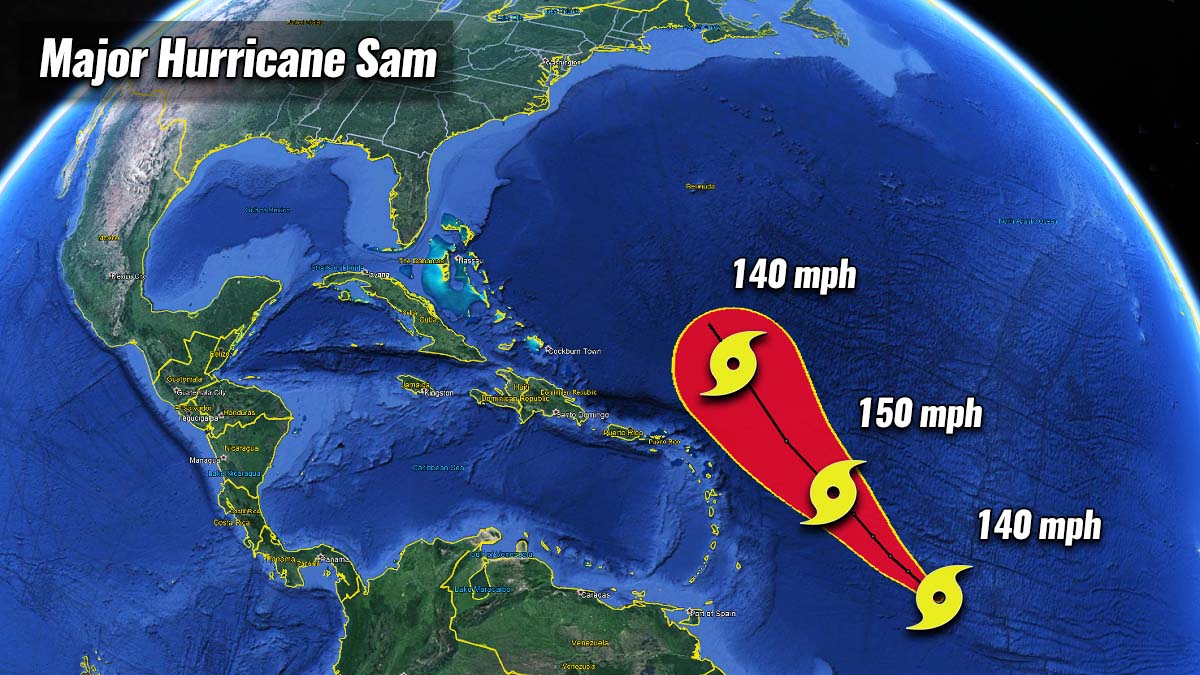
Favorable oceanic and environmental conditions across the central Atlantic allowed Sam to explosively intensify into a powerful Category 4 hurricane, packing 140 mph winds. Sam is now the 2nd major storm of the Atlantic Hurricane Season, continues west towards the northern Lesser Antilles in the coming days.
Sam underwent extremely rapid intensification and became the 7th hurricane of the 2021 season in the Atlantic Basin. The 2nd most powerful storm of the year is expected to continue intensifying, grazing into even better conditions over the next 2-3 days.
Improving conditions are ahead of the system with much warmer waters and the atmospheric MJO wave are coinciding together while hurricane Sam will be traveling dangerously close to the northeastern Caribbean Islands by Wednesday into Thursday.
VERY HOT ATLANTIC WATERS AND ATMOSPHERIC MJO WAVE
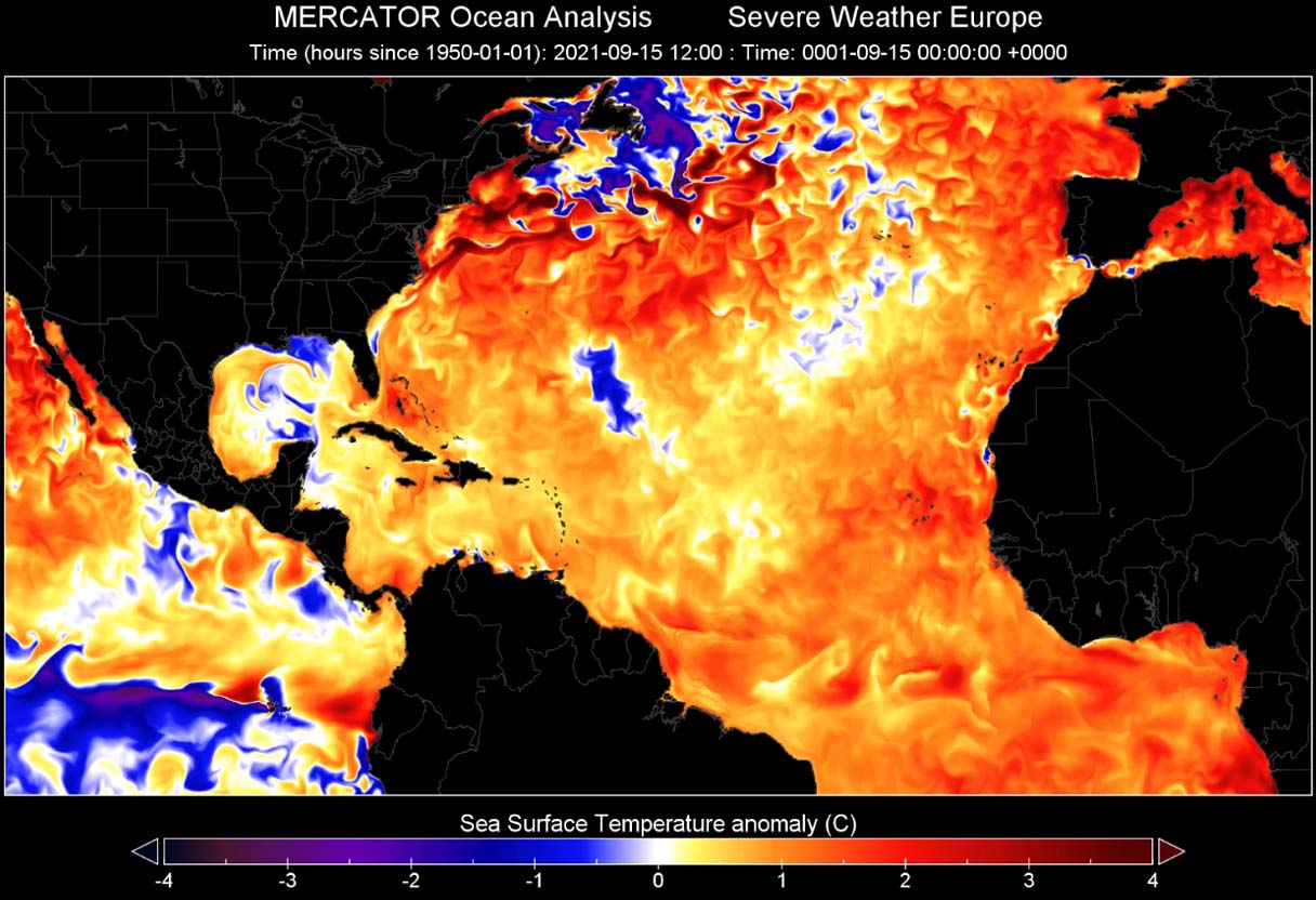
The sea temperature anomalies across the whole Atlantic Basin are significantly above normal this September, with strong positive anomalies up to 2-3 °C warmer, even more in some areas. This includes the western tropical Atlantic, the Caribbean region, part of the Gulf of Mexico. The warmest sea waters are found around the Lesser Antilles, the Bahamas, Cuba, and Florida.

Temperatures in this part of the Atlantic are ranging from around 29 to 31 °C, which is extremely warm for late September and these temperatures are forecast to remain in a similar range also through at least the first half of October.
Very warm water temperatures, if combined with strong upper-level support, usually lead to very rapid to even explosive development of tropical cyclones during the peak and especially during the final months of the Atlantic hurricane season. Exactly what happened with Sam this weekend.
While the very warm oceanic waters are not the only ingredient that fuels tropical cyclones, there has to be strong upper-level support in place as well. That is when we also look at the atmospheric waves aloft. The most important is the MJO wave, known as the Madden-Julian Oscillation.
Let’s first talk about some basics conditions what exactly the MJO is and why is it a so important feature in the tropical region. The MJO wave is known to significantly influence the activity during the Atlantic Hurricane Season, it can suppress it but also can lead to a significant boost in tropical development. Here is why.

The general concept of the weather dynamics across the tropical region is pretty much different from the mid-latitude regions. The mid-latitudes weather has frontal systems, cold and warm fronts, while the tropical region weather mainly consists of a convective activity (thunderstorms).
Those are occurring within the large-scale pressure and wind patterns variability and a lot of the dynamics in the tropics are driven by ‘invisible’ wave-like features in the atmosphere. The Madden-Julian Oscillation (short MJO wave), is known as the largest and the most dominant source of short-term activity in the tropical region around the whole planet.
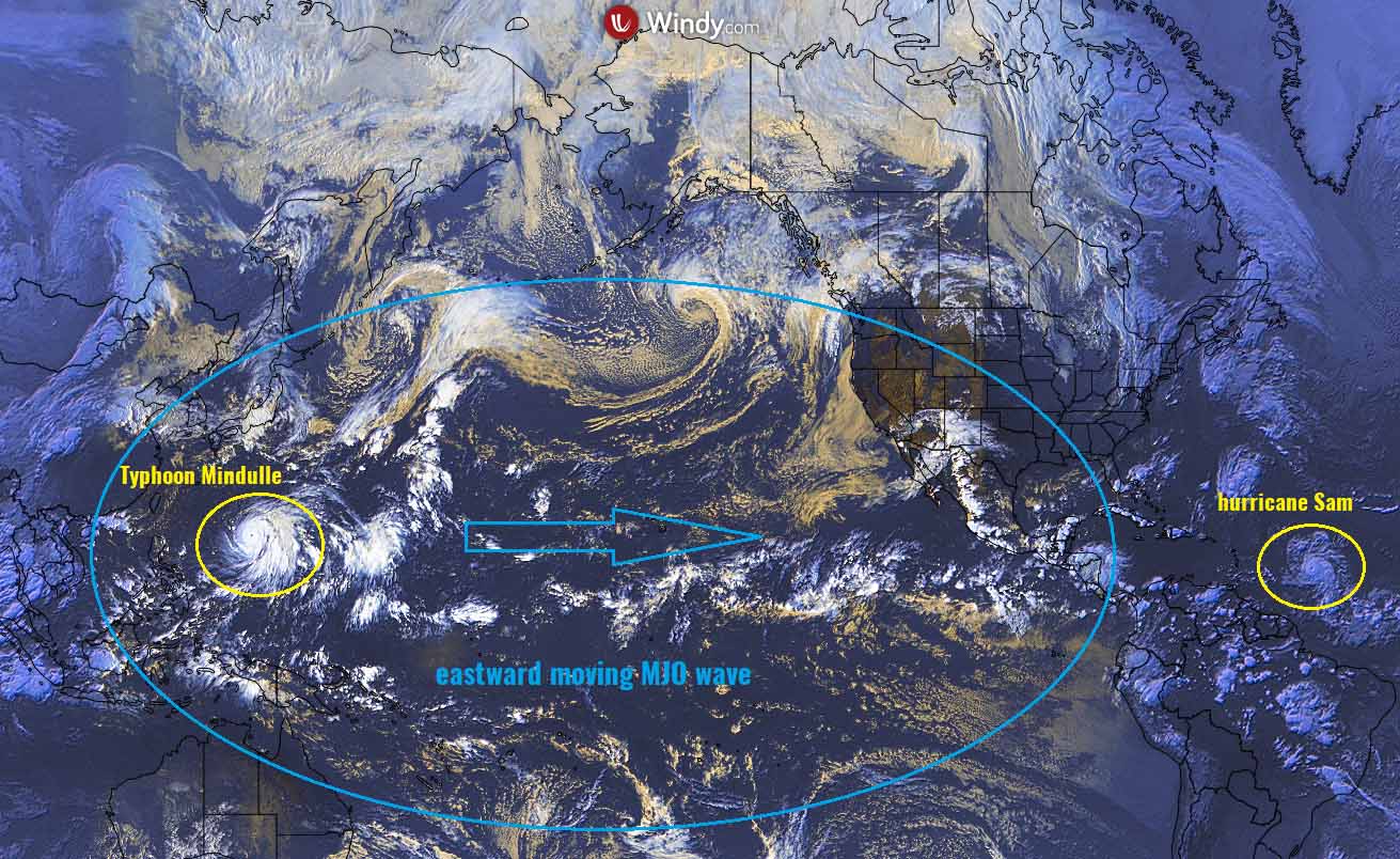
It is an eastward-moving atmospheric wave with disturbance of showers and thunderstorms, that circles the Earth in the equatorial region in about 30 to 60 days. MJO has two parts, enhanced rainfall (wet phase) with support of tropical development on one side and the suppressed rainfall or convective activity (dry phase) on the other side.
The horizontal movement of air masses is referred to as the Velocity Potential (VP) in the tropics, a special indicator of the large-scale divergent flow in the upper levels of the atmosphere.

The chart above, provided by Michael J. Ventrice, indicates a deep MJO wave (blue tones) entering the Caribbean region and western Tropical Atlantic by early October. The deeper the wave is, the more supportive tropical conditions typically develop.
Note that Hurricane Sam has now gradually being overspread by these significantly better conditions aloft, so the general weather pattern leads to a low wind shear environment which allows a tropical cyclone to organize. Often also leading to an explosive development as Sam underwent this weekend.
SAM IS NOW A POWERFUL CATEGORY 4 HURRICANE, EXPECTED TO INTENSIFY FURTHER THROUGH MONDAY
The very warm Atlantic waters and the incoming major and deep atmospheric (MJO) wave aloft we talked about earlier, has now allowed hurricane Sam to rapidly strengthen into the next major storm. After Ida, Sam is the 2nd major hurricane (Category 4) of the Atlantic hurricane season 2021.
Sam was a Tropical Storm with maximum sustained winds of 60 mph on Thursday afternoon and increased to 80 mph by Friday afternoon. Then, Sam took a higher gear and underwent an explosive intensification and increased its maximum sustained winds to 140 mph by Saturday afternoon. So a 60 mph increase in just 34 hours.

Note: We define rapid intensification when an increase in a storm’s maximum sustained winds of 35 mph or more occurs within 24 hours. Sam almost double that, so very rapid/explosive intensification was underway.
First, hurricane Sam will come dangerously close to the Leeward Islands on Wednesday and Thursday, traveling to its immediate north.

Eventually, hurricane Sam could turn toward the United States late this coming week, depending on how far south its track will bring in in the next few days. Statistically, the lower by latitude it goes, the more chances there as its trajectory will be more westerly than northerly direction, so it turns closer to the U.S. mainland.
The tropical-storm-force winds are extending up to 60 miles around the center, while hurricane-force winds up to 35 miles. So still a relatively narrow area for now.

The central pressure in Sam’s eye is down to almost 940 mbar, as being judged by both the satellite analysis and also the NOAA hurricane hunters aircraft. The first few passes through the eye are showing extremely intense eyewall winds, with up to 140 knots (155-160 mph).
This is a borderline to a Category 5! When a hurricane is relatively small as Sam currently is, the most intense winds are closer to the center.

Major hurricane Sam is now a powerful and solid Category 4 storm. It will continue intensifying, as there are absolutely no real chances of weakening as conditions along its future track are ideal, with very hot oceanic waters and low shear within the gradually emerging MJO wave aloft.
The various specters of the satellite images are indicating that Sam is in really near-ideal conditions, with very cold cloud tops and powerful upper-level outflow ventilation. This is a typical example when the tropical cyclone is grazing across favorable conditions for rapid intensification.
On Saturday, Category 4 Sam is still about 1,000 miles to the east-southeast of the northern Leeward Islands, moving only slowly westward with about 10 mph. With Sam moving further west, the hurricane will produce larger swells that propagate far away from the cyclone’s center. High swells will generate large waves and rough surf conditions along the shores of the Leeward Islands facing east-southeast while the storm is still far away.
After passing just to the north of the Lesser Antilles on Wednesday and Thursday, Sam is forecast to begin a gradual turn towards the north-northwest. But the exact track is still unknown as it depends on the turning point. The later it turns, a more westerly track later is possible.
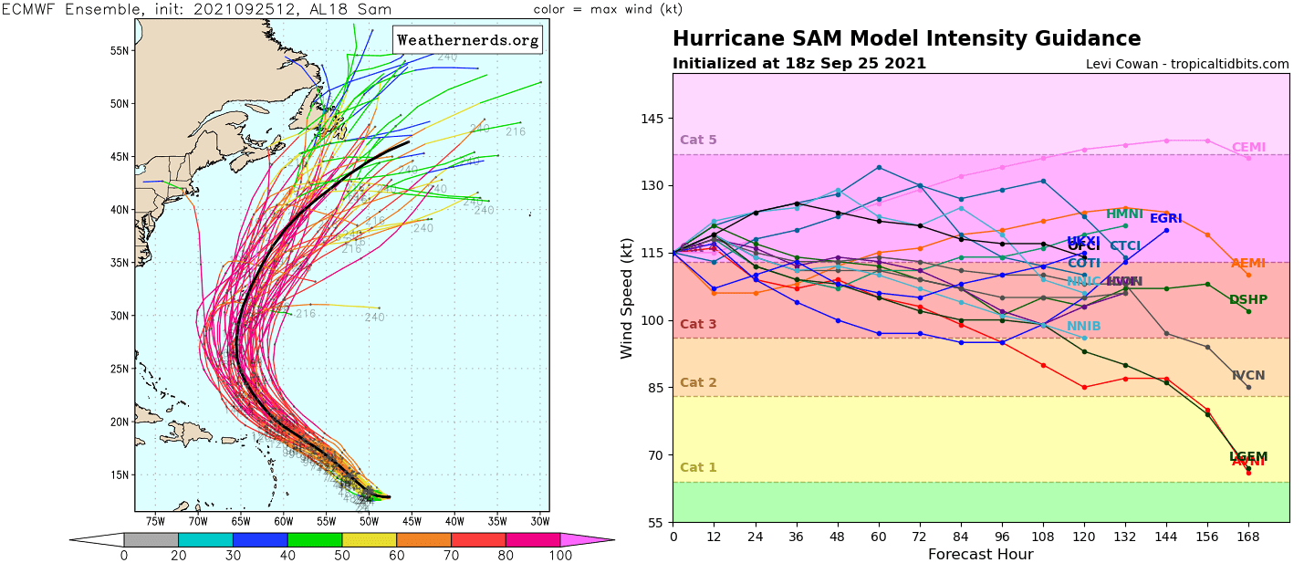
As we could see from the ensemble forecast map above, chances it tracks very near the northernmost islands that are still in the game. Later this coming week, Sam could be dangerously close to Bermuda. The right chart above also indicates the current weather model simulations of Sam’s intensity over the next 7 days.
The majority of the models keep the hurricane at a powerful Category 4 intensity, while some potential is also there to strengthen close to a 5 or even weaken into a strong Category 3. The intensity often depends on the Eyewall Replacement Cycle (EWRC), when the inner eyewall of the hurricane collapses and is replaced by a larger, outer eyewall.

Above is another ECMWF ensemble and GFS model comparison chart regarding Sam’s potential future track. We can see a very large position spread for hurricane next week, possible from the Hispanola to the northeast of Bermuda by Saturday, October 2nd.
Although most of the model members keep Sam to the east of the Contiguous U.S., there is enough track uncertainty that the East Coast should continue monitoring where the system could turn late this final week of September.
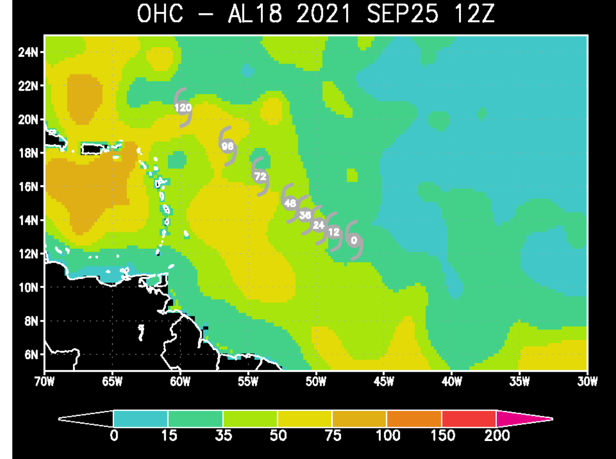
Hurricane Sam is forecast to travel into much warmer waters in the following days, so additional strengthening is quite likely, the Ocean Heat Content (OHC) map above is definitely pretty obvious in this regard. There are surely chances Sam could even strengthen into the strongest intensity, a Category 5 before Monday.
But the environmental and oceanic conditions are also forecast to remain very favorable after Sam passes near the Lesser Antilles on Thursday. The next potential impact could be Bermuda, and with a very dangerous potential if the ECMWF model chart (below) is right.

The forecast chart is showing the potential wind swath over the next 10 days, bringing a very powerful hurricane Sam very near or even across the Bermuda island. However, this is a week ahead, and the tracking error for more than 5 days in advance is still large, so the track might change by then.
OCTOBER’S ATLANTIC HURRICANE SEASON BRINGS MORE STORMS CLOSER TO UNITED STATES, ESPECIALLY FLORIDA
During the late September and October period, the tropical activity is gradually shifting into the western Atlantic and towards the Caribbean region, so tropical cyclones could impact the more vulnerable land, as well as track further north towards the United States.
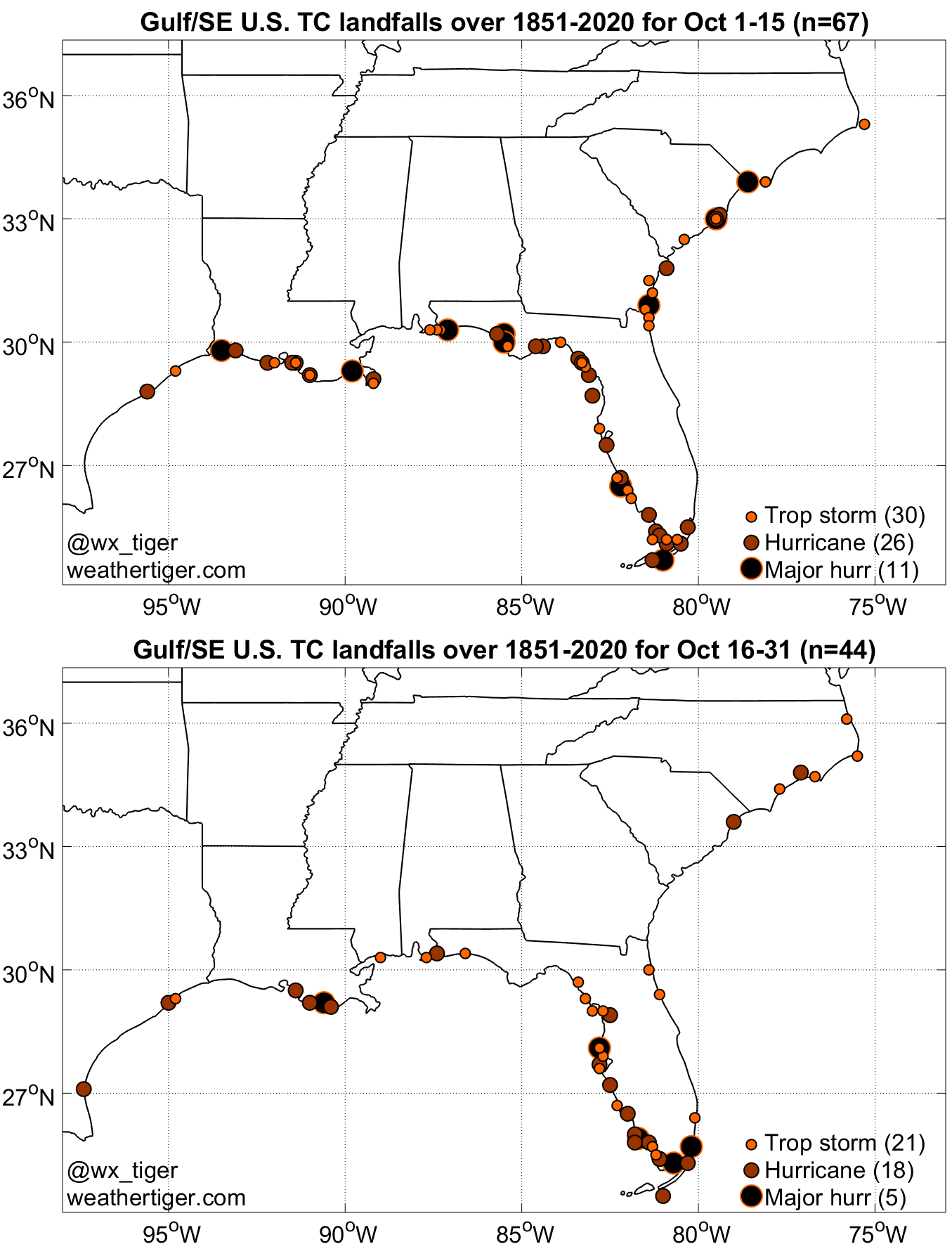
Note that the Florida peninsula, for example, has a statistical peak of landfalls during mid-October when late-season landfalls cluster on the Florida Gulf Coast.
Although the recent period of tropical activity in the Atlantic was pretty hyperactive with 6 hurricane formations in the last 45 days this season, the extremely warm sea waters and the emerging atmospheric MJO wave are expected to generate more dangerous storms.
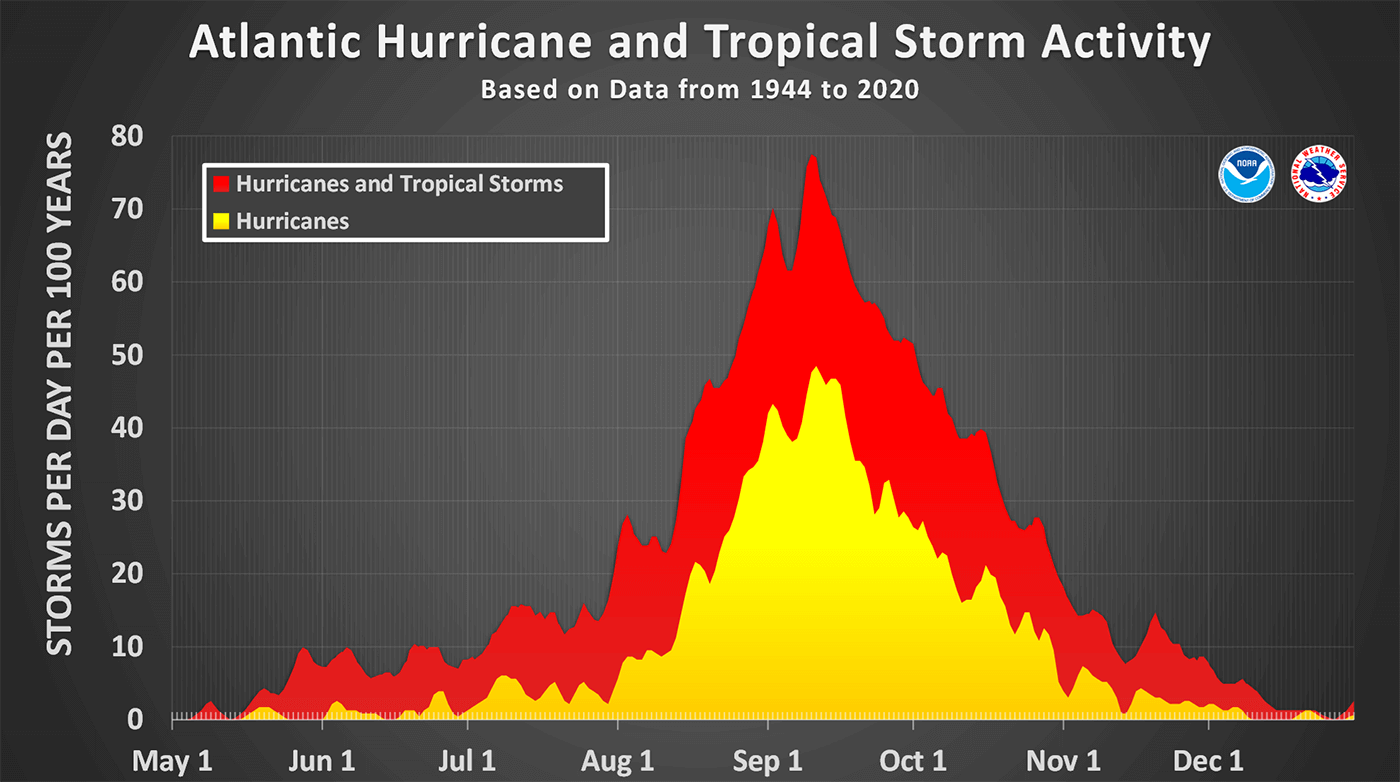
The statistical graphics above indicate the tropical cyclone frequency during a typical Atlantic Hurricane Season. These numbers are averaged over the last 70 years and represent the number of storms per day per 100 years. We can see obvious peak activity in early September but also October has a statistical burst in a higher frequency of storms.
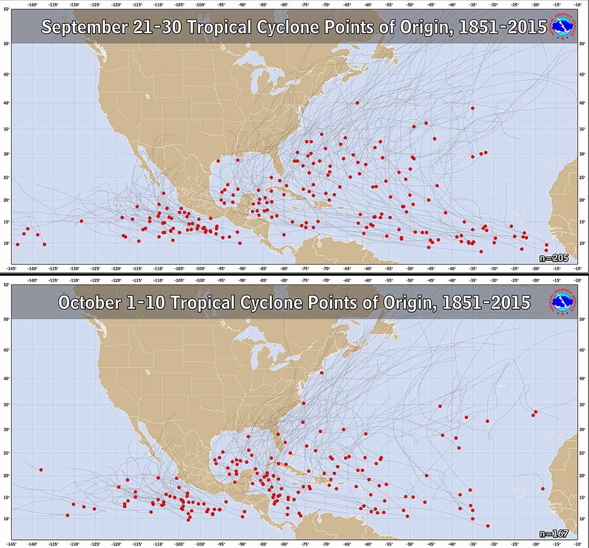
It is very important to note that the main change from September to October is the shift of the activity closer to the Caribbean and U.S. mainland. The typical tropical development areas in October indicate that the majority of the tropical cyclones develop in the western tropical Atlantic.
This also tells us why the secondary peak of the activity quite often develops stronger hurricanes that graze into the Caribbean region and towards the U.S. mainland during the late hurricane season. During the Atlantic Hurricane Season last year, such examples of powerful hurricanes were hurricanes Delta, Epsilon and hurricane Zeta, all occurring in October.
Years of tropical events during the late hurricane season indicate that weather patterns in October shift the storm trajectories from the western tropical Atlantic towards the north and then northeast. This means that the potential for the landfall of tropical storms and hurricanes also increases for Florida and the U.S. mainland, and the East Coast.

The attached chart above is showing a historical occurrence of tropical systems throughout the month of October. We can see that the Caribbean region, the eastern Gulf of Mexico, Florida, and the East Coast have the highest frequency of tropical cyclones. The while arrows are showing the prevailing tracks of tropical cyclones (storms or hurricanes).
ATLANTIC HURRICANE SEASON LIKELY LOOKING FOR A SUPPLEMENTARY LIST IN OCTOBER
After the statistical peak (Sept 10th) of the Atlantic Hurricane Season, the hyperactivity continues. As of Sept 25th, the Atlantic Hurricane Season is running at more than 80 % of the average number of named cyclones in a typical year. Sam is the 18th named storm of the Atlantic Hurricane Season 2021, Teresa was the 19th, formed on Friday this week.

The tropical activity in the Atlantic is therefore running well ahead of the typical schedule and is also forecast to remain above normal until the hurricane season is officially over by the end of November. According to dr. Philip Klotzbach, there are normally about 1.5 named storms, 5 hurricanes, and two major hurricanes by Sept 25th.
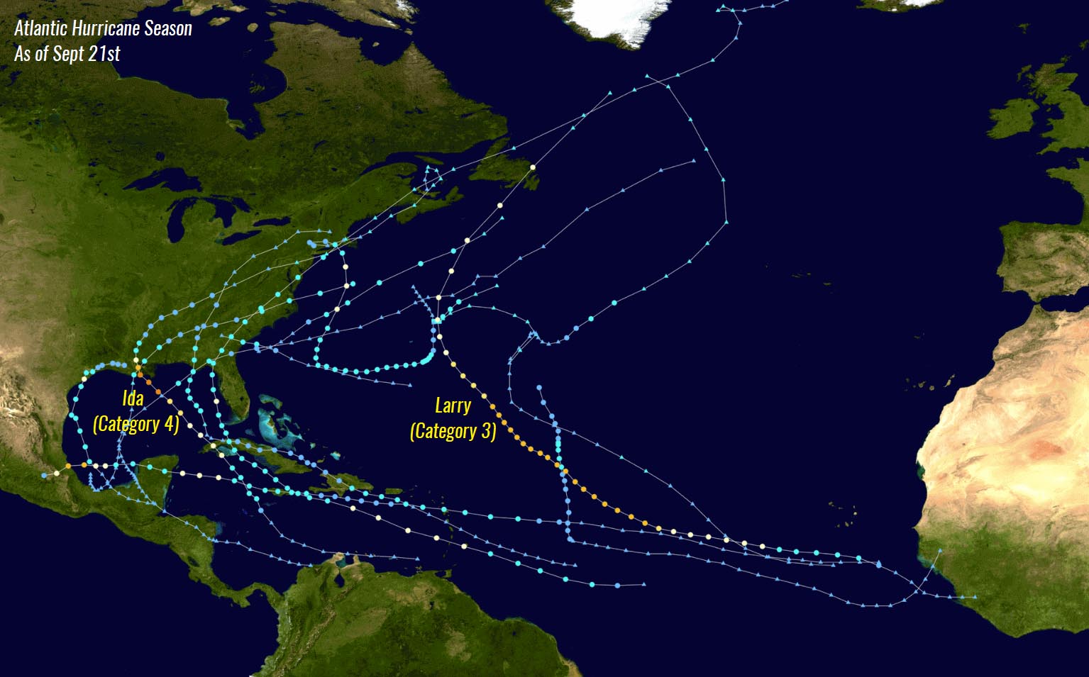
With already 7 hurricanes and also 4 major hurricanes besides Sam (Grace, Larry, and Ida) formations, the hurricane statistics are running at 50 % above normal.
The recent NOAA seasonal outlook update hints that above-normal activity will continue, with possibly up to 10 more tropical storms and even 5 hurricanes by the end of the season that officially ends on November 30th. Note that up to three more storms could also impact the United States mainland before the season is finally over.
So this can tell us that it is very likely that the Atlantic Hurricane Season will soon enter the uncharted territory as more tropical cyclones will follow after Sam and Teresa in the coming weeks. Only Victor and Wanda are left from the official list, so the supplementary list will be needed.

A supplementary tropical cyclone list above was predetermined by the World Meteorological Organization (WMO) this spring. This list will bring more friendly named storms, as using Greek alphabets made it quite difficult to track in the past. Those two Atlantic hurricane seasons we used extra names were 2005 and 2020.
We are closely monitoring the further development of hurricane Sam and further forecast updates are scheduled on Monday and Wednesday. The general forecast track will also be much clearer when the cyclone will be closer to the Lesser Antilles. Stay tuned for details on the potential impacts late this coming week.
Also please make sure to bookmark our website to not miss any future updates, and if you have seen this article in the Google App (Discover) feed, do not hesitate to hit the like button (♥) there to subscribe to more of our forecasts and latest discussions on various weather topics.
** Images used in this article were provided by Windy, , and NOAA.
Interested in how winter 2021/22 forecast is? We have prepared a special detailed outlook out by various weather models: