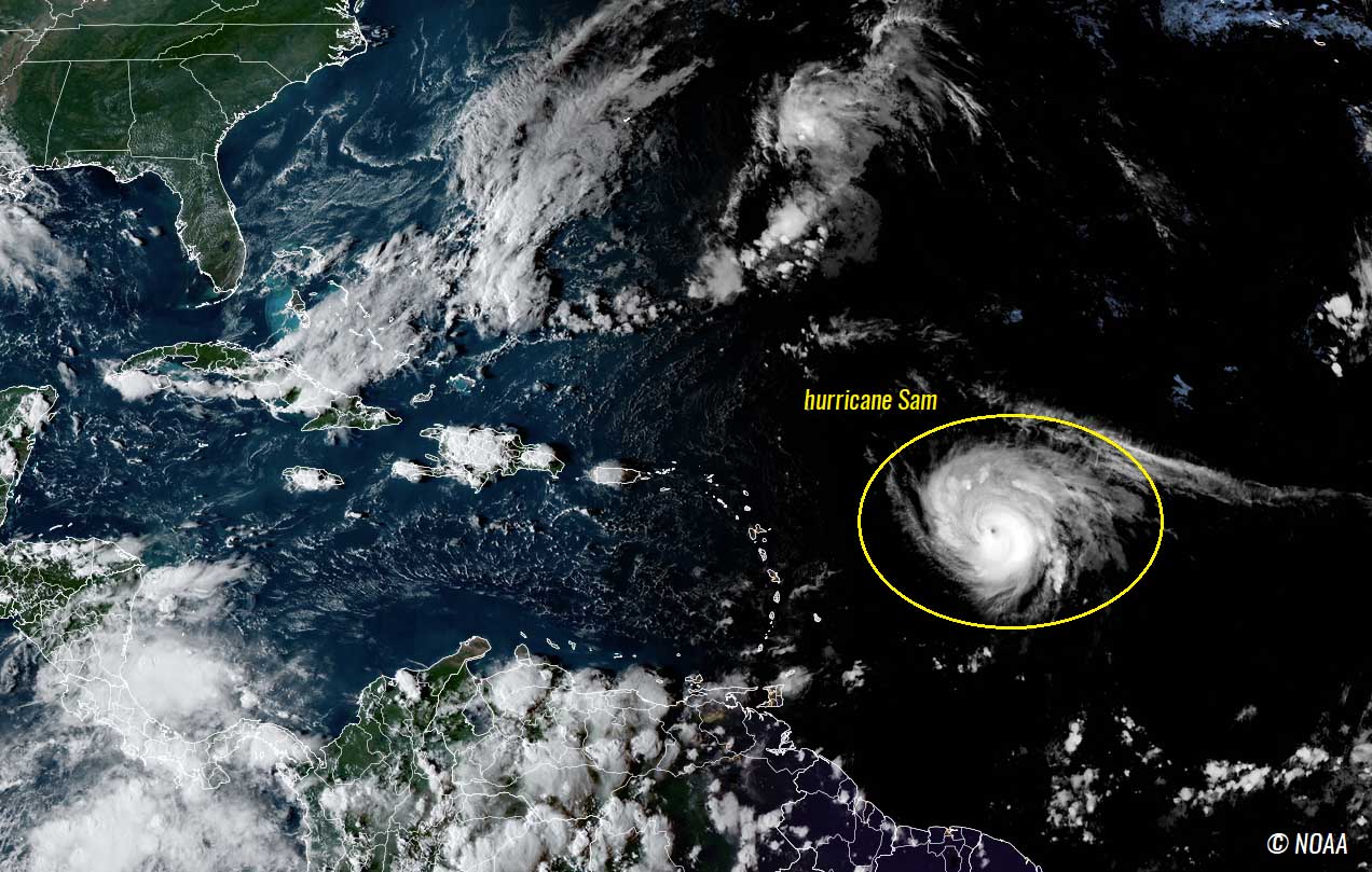
Very warm oceanic waters and improved environmental conditions across the western and central tropical Atlantic brought hurricane Sam to a powerful high-end Category 4 storm, peaking at 155 mph winds on Sunday. Sam is the strongest storm of the Atlantic Hurricane Season 2021, continues northwest to the north of the northern Lesser Antilles, and heads for its potential next impact as a major hurricane to Bermuda the next weekend.
Sam underwent extremely rapid intensification of its wind intensity and bottomed out its central pressure to almost 930 mbar, becoming the 7th hurricane of the 2021 season for the Atlantic Basin. Sam has surpassed the major hurricane Ida which had the peak sustained winds of 150 mph, and will continue grazing towards the northwest in the coming days, before passing near Bermuda.
Still favorable oceanic and environmental conditions are in place ahead of the system, with much warmer waters and the atmospheric MJO wave emerging from the west. While hurricane Sam will be traveling to the north of the northeastern Caribbean Islands through Wednesday into Thursday, a gradual turn more towards the north is forecast late this week.
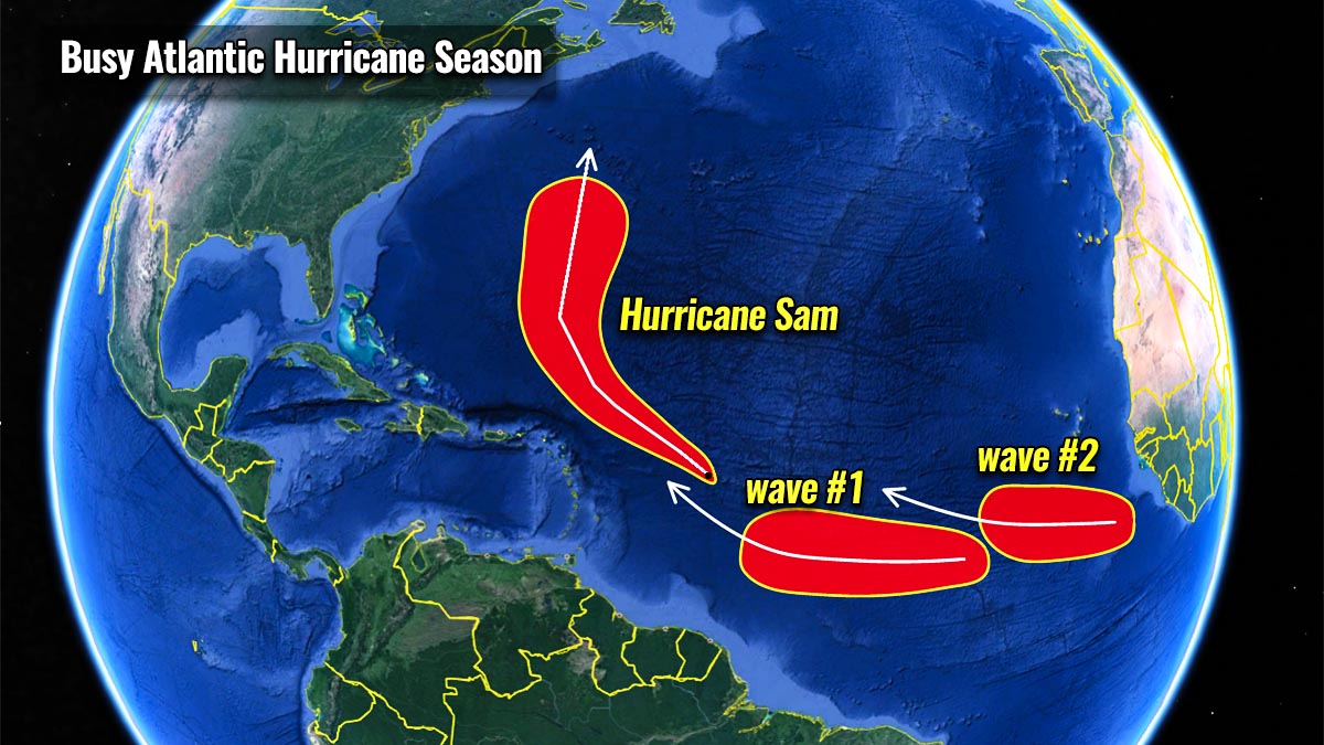
In addition, two more tropical waves are being monitored in the eastern Atlantic that is likely to become the next tropical storms this week, Victor and Wanda. Once they form, they will be ending the official list of tropical cyclones for the Atlantic Hurricane Season 2021, two months before the official end of the season.
A supplementary list of cyclone names will then be in use.
MAJOR ATMOSPHERIC MJO WAVE OVERSPREADS THE HOT ATLANTIC WATERS
The sea temperatures of the Atlantic Basin are significantly warmer than normal this September, with a strongly positive anomaly of up to 2-3 °C or even more in some areas. This also includes the western Atlantic, as well as the Caribbean region and part of the Gulf of Mexico.
The warmest pockets of sea waters can be found around the Lesser Antilles, Cuba, the Bahamas, and the southern Florida peninsula.

The sea temperatures in this part of the western Atlantic are at around 29 to 31 °C, which is extremely hot for late September. These temperatures are also forecast to remain in a similar range at least through the first half of October.
Keep in mind that very warm water temperatures, when combined with strong upper-level support, normally lead to very rapid to even explosive development of tropical cyclones. This very often happens during the peak and especially during the final months of the Atlantic hurricane season when seas are the warmest.
The video animation above is showing how the Atlantic basin waters have been warming up over the recent weeks. This is also why the tropical Atlantic has been so hyperactive since early August in this hurricane season.
And this is exactly what has happened with Sam this past weekend, explosive strengthening into a high-end Category 4 storm with 155 mph winds.

The sea temperature also has anomalous warmth across the MDR region (Main Development Region), a virtual region extending between the west coast of Africa and the Caribbean Sea where the majority of the Atlantic tropical cyclones develop.
There are two most important ingredients from tropical activity. Besides the very warm oceanic waters fueling the convective storms, there must also be strong upper-level support in place as well. That is when the atmospheric waves aloft come into the game. The most important atmospheric wave is the MJO wave, known as the Madden-Julian Oscillation.
First, here are some idealized conditions so we can learn what exactly the MJO wave is and why is it a so important ingredient and large-scale feature in the tropical region around the world. The MJO wave is known to bring a significant influence to the activity during the Atlantic Hurricane Season. It can basically suppress the activity but also can lead to a significant boost in tropical development. Here is what happens.
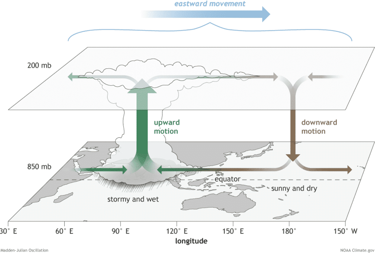
The tropical region’s general weather dynamics are quite a lot different from the mid-latitude regions. The mid-latitudes weather has frontal systems with cold and warm fronts, while the weather in the tropical region mainly consists only of a convective activity (thunderstorms).
These thunderstorms are occurring within a very large-scale pressure and wind variabilities, and a lot of the activity in the tropical region is driven by ‘invisible’ waves or wave-like features in the atmosphere. The Madden-Julian Oscillation (MJO wave) is the best example of this. Known as the largest and also the most dominant source of short-term activity in the tropical region around the Earth.
MJO wave is an eastward-moving atmospheric wave, a tropical disturbance consisting of showers and thunderstorms. It circles the Earth in the equatorial region in about 30 to 60 days. MJO wave has two parts, one is the enhanced rainfall (wet phase) that supports a tropical development and the suppressed rainfall and convective activity (dry phase) on the other side.
The horizontal movement of these air masses is known as the Velocity Potential (VP) in the tropics. This is a special indicator of the large-scale divergent flow in the upper levels of the atmosphere which allows the upward motion of the storms – convection.

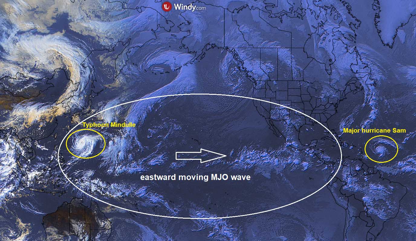
The chart above that was provided by Michael J. Ventrice, indicates a textbook large and a deep MJO wave (dark blue tones) emerging the Caribbean region and western Tropical Atlantic by early October from the west. The deeper the wave is, the more supportive tropical conditions normally follow for a few weeks period.
As we could recently see, Hurricane Sam has gradually been overspread by these significantly better conditions in the upper levels. So the general weather pattern has brought a low wind shear environment which allowed a tropical cyclone to organize. Often also leading to very rapid or explosive development, exactly like hurricane Sam underwent this past weekend.
MAJOR HURRICANE SAM PEAKED AS A BORDERLINE CATEGORY 5 STORM, NOW GRADUALLY TURNING TOWARDS BERMUDA
Significantly warmer than normal Atlantic waters and the incoming deep atmospheric MJO wave aloft we talked about earlier has allowed hurricane Sam to explosively intensify into the strongest storm of the year, Sam was the 2nd major hurricane (Category 4) of the Atlantic hurricane season 2021, reached its peak this past Sunday.
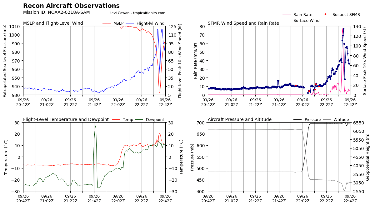
Remember, that Sam was a Tropical Storm with maximum sustained winds of 60 mph last Thursday afternoon and took a higher gear and underwent very rapid intensification and increased its maximum sustained winds to 155 mph by Sunday afternoon. In this period, Sam had a 60 mph increase in just 24 hours over the weekend.
For the tropical or mid-latitude cyclones, we define a rapid intensification rate when an increase in a storm’s maximum sustained winds is of 35 mph or more within 24 hours. Sam has almost doubled that, due to very hot waters the system grazed into over the weekend.
Hurricane Sam was undergoing an Eyewall Replacement Cycle (EWRC) on Monday and is forecast to travel to the north of the Leeward Islands on Wednesday and Thursday, while gradually taking a more northerly trajectory. Due to the EWRC, the tropical-storm-force winds have weakened first, but already increasing to around 50 miles around the center, while hurricane-force winds up to 30 miles.

As Sam had a pinhole eye, this is often the case that EWRC has a strong effect on the system’s intensity during the replacement cycle. But Sam is expected to re-intensify and become stronger again on Tuesday and remain a major hurricane until it comes closer to Bermuda over the weekend.
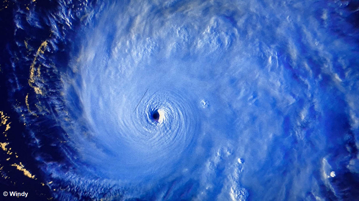
The central pressure in Sam’s eye has bottomed out just slightly above 930 mbar, as being estimated by the satellite analysis and also confirmed by the NOAA hurricane hunters aircraft. A number of aircraft passes through the eye have shown extremely intense eyewall winds, with up to 140 knots (155 mph) being the highest.
This was a borderline to a Category 5 which starts at above 156 mph! When a hurricane is relatively small as Sam was, the most intense winds are normally closer to the center. Sam’s central pressure drop was the fastest on record for any storm being so east in the tropical Atlantic in September.
Major hurricane Sam is now back at a solid Category 3 storm. It will likely continue intensifying further once the Eyewall Replacement Cycle is complete, thanks to very warm oceanic waters remaining while wind shear is low within the gradually emerging MJO wave aloft.
The various specters of the satellite images over the weekend were showing how hurricane Sam was in favorable conditions, with very cold cloud tops of compact nearly symmetrical eyewall and powerful upper-level outflow ventilation. This is a typical example when the tropical cyclone is grazing across ideal conditions for rapid or explosive intensification.

Large swells generated by hurricane Sam are affecting the Leeward Islands and will spread to portions of the Virgin Islands, Puerto Rico, Hispaniola, the Bahamas, and towards Bermuda by Friday this week. Significant swells will likely reach the east coast of the United States and Atlantic Canada by the weekend as well.
These swells will likely cause life-threatening surf and rip current conditions, and beachgoers and other interests along these coasts are urged to follow the advice of lifeguards and local officials through the upcoming weekend.

After passing just to the north of the Lesser Antilles on Wednesday and Thursday, Sam is forecast to begin a gradual turn towards the north and track towards Bermuda. The super-ensemble chart below is indicating that chances for Sam to reach the U.S. East Coast are now minimal.
The majority of the models keep the hurricane at a powerful Category 3 to 4 intensity over the next few days. Note that the hurricane intensity often depends on the Eyewall Replacement Cycle (EWRC), when the inner eyewall of the system collapses and is replaced by a larger, outer eyewall. Winds are then expanded across a broader area.
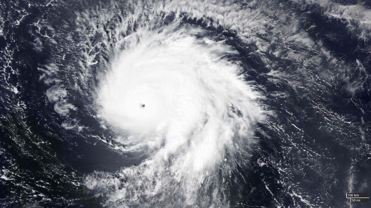
The above impressive visible satellite image indicates hurricane Sam during its peak time hours, very near the Category 5 strength at that moment. The structure is absolutely textbook, with pinhole eye and ideal upper-level outflow ventilation and cyclonic bands.
Although Sam has had some fluctuations in the intensity this Monday, the general oceanic conditions remain very favorable to support a re-strengthening throughout this week. The chart below represents an Ocean Heat Content (OHC) with good water conditions remaining ahead of the system.

As said, the next potential impact of hurricane Sam could be Bermuda, as the system’s track is forecast to be dangerously close to the island over the next weekend.
The forecast ECMWF model chart (below) is indicating a large swath of intense hurricane-force winds of Sam, passing near Bermuda on its way to Atlantic Canada next week.

The forecast chart above is showing the potential swath of strongest winds over the next 10 days, hinting that hurricane Sam will keep grazing across this part of the Atlantic for almost another week.
TWO MORE STORMS, VICTOR AND WANDA, LIKELY TO FORM THIS WEEK
Tropical Atlantic is, besides hurricane Sam, far from being calm also in the coming days. There are additional two areas (tropical waves) monitored by the National Hurricane Center that will likely become the next tropical storms.
The first wave is a broad area of low pressure located several hundred miles southwest of the Cabo Verde Islands. It is producing disorganized showers and thunderstorms with the environmental conditions quite conducive for further development of this tropical disturbance in the coming days. A tropical depression is likely to form this week, while the activity will be moving west-northwestward at 5-10 mph over the central tropical
Atlantic.
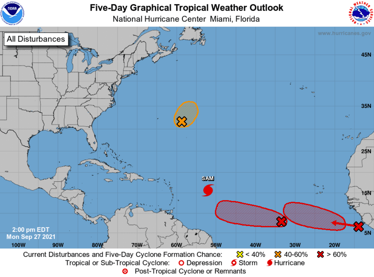
Another tropical wave is located just offshore the west coast of Africa and producing a large area of disorganized showers and thunderstorms. With the upper-level winds conducive for gradual development, another tropical depression is likely to form in the next few days while it follows further west into the tropical Atlantic behind the first wave.
The NHC is giving both systems a medium, 50 % chance to become a depression in two days and a tropical storm within the next 5 days.

The next two and the final names from the tropical cyclone list are Victor and Wanda.
ATLANTIC HURRICANE SEASON IS THE PEAK MONTH FOR LANDFALLS IN FLORIDA
September and October are typically the most active period when the majority of the tropical cyclone formations occur. However, the tropical activity is also gradually shifting into the western Atlantic and the Caribbean region as go deeper into fall. Tropical storms and hurricanes are then able to impact the more vulnerable land, and also turning north towards the United States.

Actually, the Florida peninsula has a statistical peak of tropical storm/hurricane landfalls from mid-October onwards. This is when the late-season tropical activity cluster on the Florida Gulf Coast. This needs to be considered if you live in these areas.
The recent hyperactive period of tropical activity in the Atlantic brought 6 hurricane formations in the last 45 days this season. Mainly thanks to the extremely warm sea waters that are now boosted with the incoming atmospheric MJO wave aloft. A combo of both is expected to generate more dangerous storms in October.
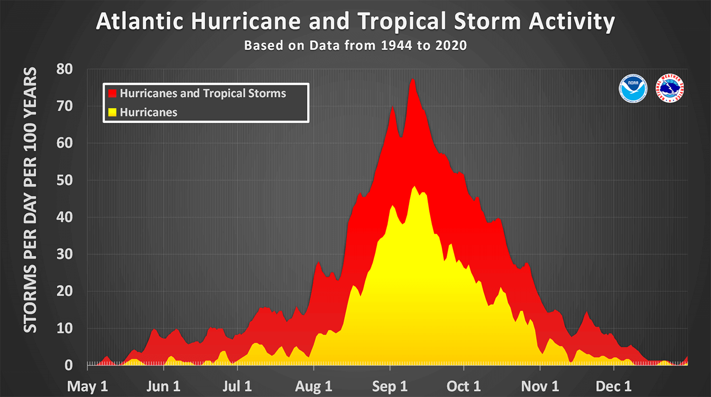
The attached graphics above indicate the tropical cyclone frequency that a typical Atlantic Hurricane Season generates. Keep in mind that these numbers are averaged over the last 70 years and represent the number of storms per day per 100 years, so a normalized number. The seasonal highest activity in early September is pretty obvious, but October is far from being a much calmer month.
As we stated above, the main change in dynamics and patterns between September and October is the shift of the tropical activity closer to the Caribbean and the United States, especially Florida. We can see how the typical tropical cyclone development hint that the majority of these formations are found in the western tropical Atlantic.
The secondary peak of the activity, actually a double statistical peak in October, quite often develops stronger hurricanes that move across the Caribbean region and turn towards the U.S. mainland during the late hurricane season months. Atlantic Hurricane Season 2020, for instance, had powerful hurricanes hurricanes Delta, Epsilon and hurricane Zeta, all occurring in October.
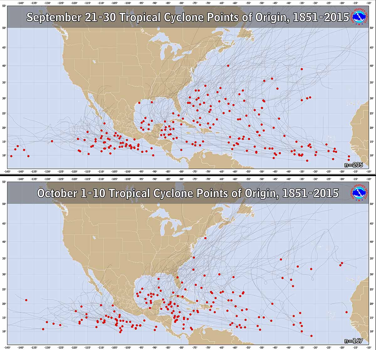
Data from the past indicate that the late hurricane season weather patterns throughout October normally shift the storm trajectories from the western tropical Atlantic towards the north and then northeast. This leads to the increased potential for the landfall of tropical storms and hurricanes for Florida and the U.S. mainland, and the East Coast as well.

As we can see from the image above, the historical occurrence of tropical systems throughout the month of October is the highest on the west. The Caribbean region, the eastern Gulf of Mexico, Florida, and the Atlantic near the East Coast has the highest frequency of tropical cyclones. The white arrows indicate where the prevailing tracks of tropical cyclones (storms or hurricanes) normally occur.
TWO TROPICAL CYCLONE NAMES LEFT, ATLANTIC HURRICANE SEASON NEEDS A SUPPLEMENTARY LIST IN OCTOBER
With hurricane Sam, and a short-lived tropical storm Teresa, the hyperactivity of the Atlantic Hurricane Season is nowhere to its end. After the statistical peak on September 10th, the hurricane season is running at more than 80 % of the average number of named cyclones in a typical year in the Atlantic. Sam is the 18th named storm of the Atlantic Hurricane Season 2021, Teresa was the 19th, although dissipated in less than a day.

According to dr. Philip Klotzbach, there are normally about 11.5 named storms by Sept 17th. Also 5 hurricanes, and two major hurricanes. With 19 named systems so far, the tropical activity in the Atlantic is well ahead of the typical schedule. The recent forecasts also hint that the Atlantic activity should remain above normal until the hurricane season is officially over.
There have already been 7 hurricanes and 4 major hurricanes besides Sam (Grace, Larry, and Ida) formations this year. So the hurricane statistics are also running at 50 % above normal.

Just recently, the NOAA seasonal outlook update hinted that the above-normal activity will continue in October and even into November. There are up to 10 more tropical storms possible, even 5 hurricanes by the end of the season that officially ends on November 30th. Three of these systems could also make landfall and impact the United States mainland in this period.
So this can tell us that it is just a matter of time when the Atlantic Hurricane Season will graze into the uncharted territory as more tropical cyclones will follow soon. With only Victor and Wanda left from the official designated list, so a supplementary list of tropical storm names will be needed.

Once the official names are over, a supplementary tropical cyclones list comes into use. It was predetermined by the World Meteorological Organization (WMO) in spring this year, replacing the Greek Alphabets list that we used for the most active years until now. The list brings friendlier named storms, as using Greek alphabets made it quite difficult to track in the past. Only 2005 and 2020, however, used it.
THE ATLANTIC HURRICANE SEASON 2021 HAS MUCH ABOVE NORMAL ACCUMULATED CYCLONE ENERGY (ACE)
When we are monitoring the Atlantic Hurricane Season strength, we also use another indicator that allows us to compare seasons with the other years. We use a so-called ACE index for this matter. An ACE is an abbreviation for the Accumulated Cyclone Energy, a technical metric that is used to express the energy used by a tropical cyclone during its lifetime.
During the 2021 Atlantic hurricane season, the number of tropical systems has been increasing pretty fast since the beginning, and many of them are intense. Judging just by the numbers, this means we are really not far behind the record-breaking hurricane season of 2020. That is why it is advised to calculate the ACE index to see how the season is standing.

Until this week, Sept 27th, the seasonal ACE index of more than 96.0 has already been accumulated by all the 19 named tropical cyclones during the Atlantic Hurricane Season 2021. The highest ACE of the season was collected by the major and long-lived hurricane Larry, ending up at 32.8 ACE during its 11 days of activity grazing across the Atlantic Ocean.

Larry actually made three times more ACE than each of the following: Major hurricane Ida (10.8 ACE), hurricane Elsa (9.5 ACE), and hurricane Grace (9.1 ACE). Actually, Larry produced more energy than all those three hurricanes together.
Hurricane Sam has been catching Larry quite fast, due to its high intensity these days. Sam’s ACE is so far at 12.7 and is expected to reach or even surpass Larry’s ACE the next weekend.

To give us an idea of what the whole Atlantic hurricane season made last year, the total generated ACE was 185.8, quite well above the statistical threshold for the ‘extremely active’ ACE category, which is set at 152.5 for the Atlantic basin. This placed last year’s Atlantic hurricane season into the Top-10 of all time, based on the Accumulated Cyclone Energy index.
Based on the number of tropical cyclones in one statistical year, the only similar season to 2020 was 2005. But its ACE ended up much higher, its final calculation was 250. While a record-breaking 2020 developed 30 tropical systems, 2005 did two less, 28. But its ACE was a way higher.

The attached chart above represents the recent Atlantic 15 hurricane season ACE and the related number of hurricanes in that particular year. The rising trend of ACE in the recent year seems quite obvious, while the highest in this period was the Atlantic hurricane season 2017.
We will continue monitoring the further development of major hurricane Sam this week and further forecast updates are scheduled after Wednesday and over the weekend when Sam nears Bermuda’s impact. The general forecast track could then bring the system to Canada next week, but a lot of yet to be defined until then.
Please make sure to bookmark our website, so you don’t miss any of our future updates. If you have found this article in the Google App (Discover) feed, feel free to hit the like button (♥) there to subscribe to more of our forecasts and the latest discussions on various weather topics.
** Images used in this article were provided by Windy, , and NOAA.
Many of you are also interested in how the winter 2021/22 forecast is going to be this year. We have published a special detailed outlook out by various weather models just recently, take a look here: