Weather forecast for October 2021 is quite a dynamic one. The month will be marked by a strong high-pressure system over North America and a transition of a colder air mass over Europe in the first half of the month.
October is the first month of the cold season in the Northern Hemisphere. It is not a fully cold month but marks a deeper step into Autumn. This is the time that temperatures start to slowly cool off over the mid-latitudes, but cooling faster over the polar regions.
The cooling creates a temperature contrast with the regions further south towards the equator. This causes stronger circulation and more energetic pressure patterns. There are 3 main atmospheric pressure regions (oscillations) in the Northern Hemisphere. We will quickly present them, as they are important in governing most of the weather patterns, producing the weather that you feel every day.

WEATHER OSCILLATIONS
We often hear about these “oscillations” every cold season. One is AO, the other is NAO, then we have QBO, PNA, EPO, WPO, ENSO, SOI,… The list is almost endless.
What are these weather oscillations and why are they important? Oscillation generally means that something is oscillating, meaning to move back and forth. In weather and climate studies, this “movement” is usually up or down, the rising and dropping of a certain weather parameter.
ARCTIC OSCILLATION
In the atmosphere, the most famous such oscillation is the Arctic Oscillation, or AO for short. We call it “Arctic” oscillation because it describes the rise and fall of pressure in the Arctic region. This means that by looking at the state of the Arctic Oscillation, we can determine the state of the atmospheric circulation and weather patterns across the Northern Hemisphere.
Below we have an image that shows the two modes of the AO. Positive mode means stronger polar circulation and negative mode means weaker. The positive mode locks the cold air into the polar regions, while the negative mode has a weaker jet stream and can release the cold towards the south.

Arctic oscillation (or any other) is used as an “index”, just like a market index at Wall Street. It means that it is used as a quick first estimate of the circulation state, just by looking at this one index, instead of going through various weather maps.
If we see that the Arctic Oscillation is currently, let’s say, -5 or +5, it can tell us a lot about what the atmospheric circulation might look like and what weather patterns are to be expected around the Northern Hemisphere.
Specifically, the Arctic Oscillation is calculated from pressure. The lower the pressure over the Arctic region, the higher (positive) the AO Index gets. Lower pressure in the Arctic region indicates deep cold cyclones and a stronger jet stream, which directly means a stronger polar vortex and a strong (positive) AO.
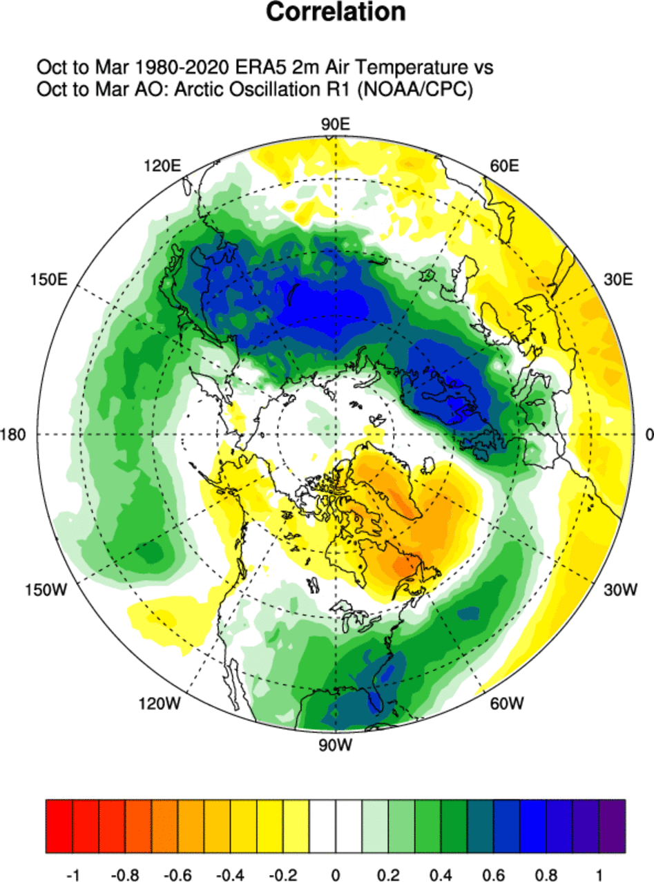
Below we have a map, that shows the sea level pressure pattern for the positive AO mode for the cold season (Oct-Mar). You can see low pressure over the polar regions, and high pressure over south-central Europe and the eastern United States. This generally ensures that the colder Arctic air is being “trapped” in the polar circle, as the jet stream is stronger and does not allow cold air to simply “spill” out.

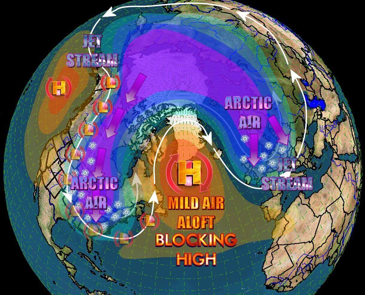
But higher pressure over the Arctic region means the jet stream is weaker, and the cold air has an easier way out of the Arctic region and towards the south. Cold shots can be more common and snowfall into Europe and/or the United States for example.
Below we have an example of an average temperature pattern during a negative AO. We see a strong tendency for colder air over much of northern Europe and east-central as well. Over the United States, we see a colder tendency in the central and eastern parts of the country.
This is something that you want to see in winter if you live in Europe or the eastern United States and you like winter weather. We have to add that nothing is 100% in weather, so there can still be warm weather in Europe and the eastern United States during a negative AO in specific situations. But they are more often an exception to the rule.
For a better representation of the Arctic Oscillation, we produced a video that shows the weather circulation in the Northern Hemisphere. You can nicely see the circulating mass of colder air over the polar regions. Also, notice how the weather patterns are developing over different continents, but stay connected in this larger system.
Current AO index forecasts call for a weak negative AO phase, which, as we now know, means higher pressure over the Arctic. We can also see, that since summer, the AO was holding more to the positive phase. But these oscillations have much more merit in the cold season and are not as often used in the warm season.

NORTH ATLANTIC OSCILLATION
Another famous (and very important) index is the North Atlantic Oscillation, or the NAO for short. Similar to the AO, this index describes the atmospheric pressure, but it describes the difference in pressure between the Icelandic low and the Azores high.
Since the North Atlantic region extends into/around the polar circle, the AO and the NAO are quite strongly connected but have their own modes of calculation. We also made a correlation plot for the NAO, which shows the connection between the NAO index and sea level pressure (SLP). Maps are produced from the NOAA reanalysis pages.

We can see that the positive NAO features a strong region of low pressure in the North Atlantic and higher pressure south in the Azores region and western Europe. This pattern amplifies the jet stream and sends the mild Atlantic airmass into the European continent. The image below from daculaweather shows the positive NAO weather.

This limits winter potential over Europe as it is pushing the colder polar air up to the northeast, away from the continent. This is also a pattern with many strong windstorms over northern Europe. On the other side of the Atlantic, it can actually be beneficial for Canada and the far northeastern United States, as the cold air is being pulled from the north on the backside of the low-pressure systems.
In a negative NAO, we usually have a blocking ridge in the North Atlantic and into Greenland. Low-pressure systems travel around it, creating an active cold air transport from the polar regions. A strong negative NAO is what every winter lover wants to see in the central and eastern United States and in Europe. The graphic below is by daculaweather.
Current NAO forecasts show it to be negative, but weakening towards the neutral zone by mid-month. As we are in October, the patterns are not yet strong enough to provide strong cold weather, as a negative NAO can during the main winter season.

PACIFIC-NORTH AMERICAN INDEX
There is one more important index, which, as the name suggests, is more specific to North America. It is called the PNA – Pacific North American index. It basically describes the pressure difference between the northwest United States and western Canada and the southeast United States on the other side.
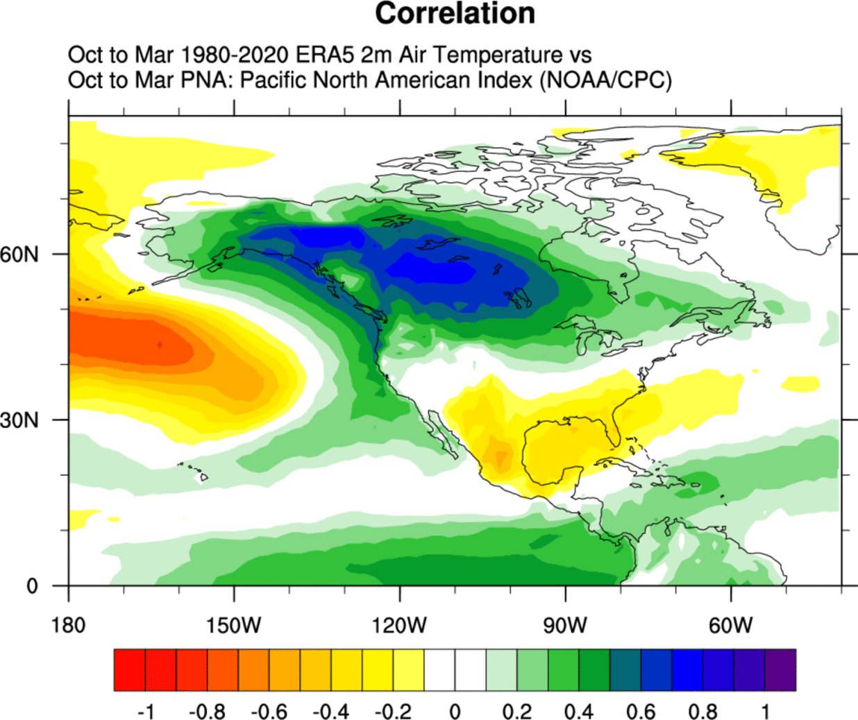
We made special plots that show the pressure pattern during the positive phase of the PNA. We can see higher pressure over the northwestern United States and western Canada and lower pressure over the southeastern United States. This means warmer weather for Canada and the northern United States.

But in a negative phase, the roles are reversed. Below we have an example for the temperatures in the negative phase of the PNA. Colder air over Western Canada and the northern United States, and warmer over the southern United States
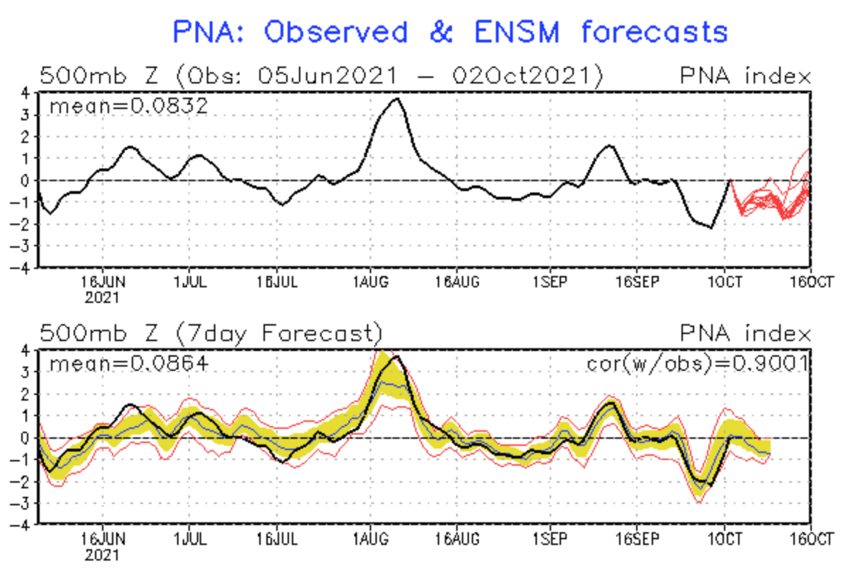
Current PNA forecasts take it into negative values. This means the opposite of what we see above. It means colder air and lower pressure in the western parts and warmer temperatures in the SE United States.
OCTOBER 2021 WEEKLY WEATHER FORECAST
We will break down the October forecast into weekly segments, looking at the development through the weeks. First, we will start with the GEFS ensemble model for the first half of the month and then add the ECMWF and CFS models to get more ideas for the weather forecast in the second half of October.
We have to add a disclaimer, that forecasts always change, especially in the extended range. So in the second half of the month, we are mainly looking at trends and patterns and comparing different models/scenarios.
OCTOBER WEATHER – WEEK 1
October will start off with all oscillations in a negative phase, and we can see why. We have higher pressure over the Arctic, keeping the AO negative. A low-pressure system is dropping down into western and northwestern Europe, keeping NAO neutral to negative. A strong ridge is climbing up over the United States and further extends into eastern Canada. As the pressure over the W coast of Canada is lower, and east Canada is under a high, this corresponds to a negative PNA pattern.
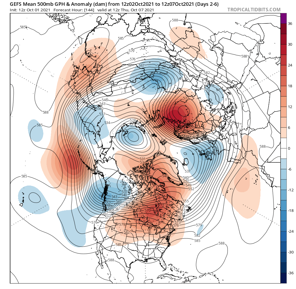
Looking closer at Europe, we see the outgoing colder air mass over the east/southeast. But a new front is descending fast into western Europe and will make its way towards the east. Currently, the regions of central/north-central Europe and Scandinavia are experiencing normal mild Fall weather. But western and Central Europe will start to experience the descending colder air.

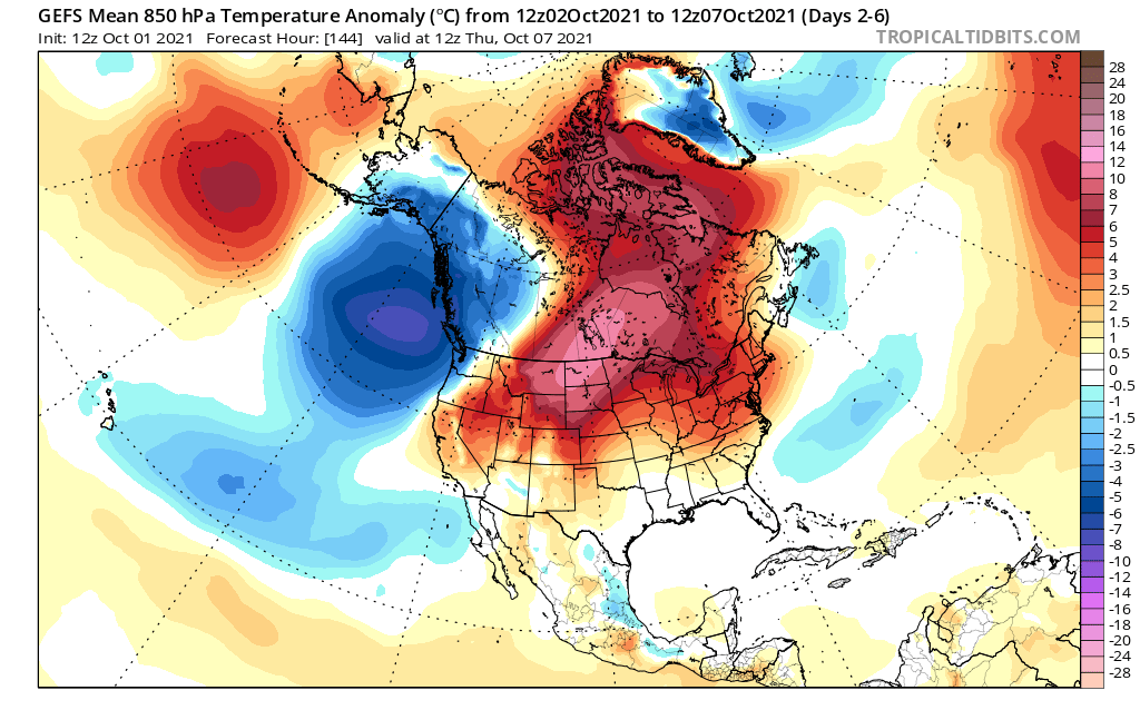
Going directly to North America, we can see much warmer than normal temperatures in the northern United States and central-north Canada. For most of week 1, this blocking pattern will dominate. It will bring warmer/mild weather to much of the northern half of the country. We can see colder air starting to descend into western Canada and the far northwestern United States.
Precipitation-wise, there will be an anomaly area on the border of the upcoming cold front, as it pushes through. We can see more precipitation than normal over central Europe, where a secondary low-pressure system will bring more rain. Drier conditions will continue in far eastern Europe.

Over North America, we can also see drier conditions taking over much of Canada and the central regions of the United States. A precipitation zone is present over the eastern United States, as a weak low-pressure zone moves over the eastern United States, circulating under the higher pressure zone.
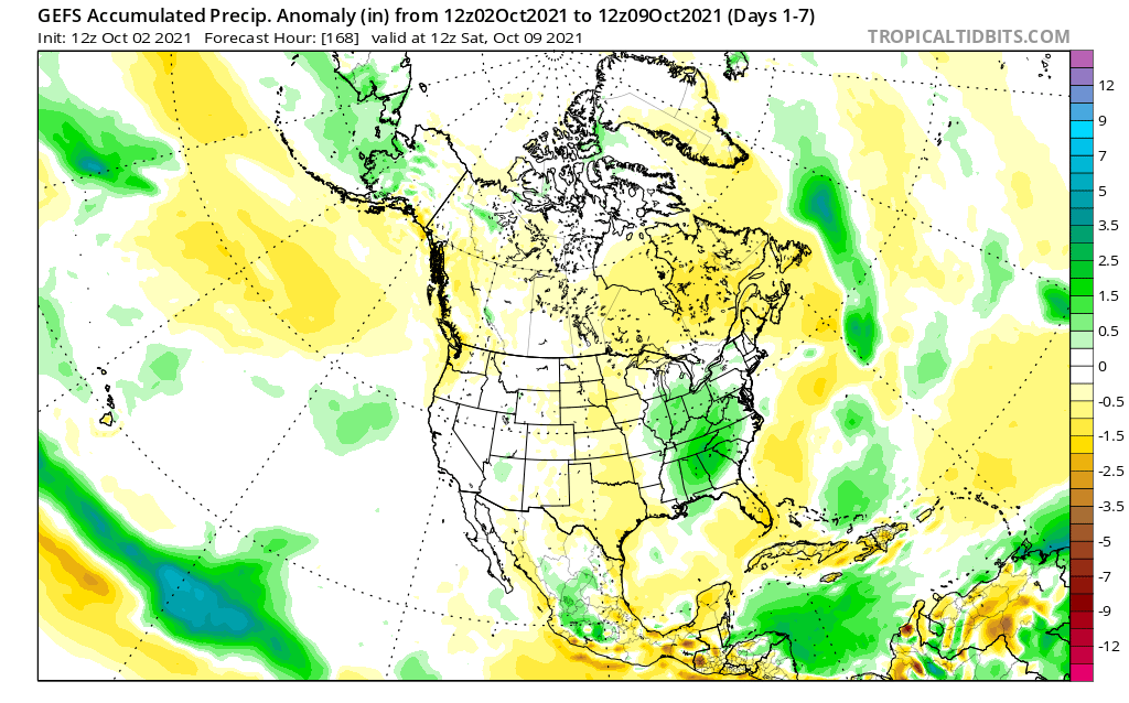
A summary for weather in October week 1, is that in Europe we will see a cold front move in from northwestern Europe, spreading into central regions. It will create a secondary low-pressure system with lots of rainfall for the south-central regions. Eastern Europe will continue with drier conditions.
Over North America, we will see mostly drier and warmer weather. Some colder conditions will be present over western Canada, while most of the United States will have warmer than normal weather. More precipitation is forecast for the eastern half of the United States, while central regions remain drier than normal. the western United States shows normal to slightly warmer and wetter conditions.
OCTOBER WEATHER – WEEK 2
The weather forecast for week 2 shows progress in the pressure pattern. The low-pressure system that was descending into Europe in the first week, will move further towards southeastern Europe. A high-pressure zone will build over northwestern and western Europe. behind it.
The North American ridge will move slightly east, making room for a low-pressure zone to enter the western United States. This will establish a more zonal (west-east) flow over the country, and stormier conditions in the western half.

We can see the spreading of the colder air over much of central and eastern Europe. Behind, we have warmer air rising over western and northwestern Europe, under the expanding high-pressure area.

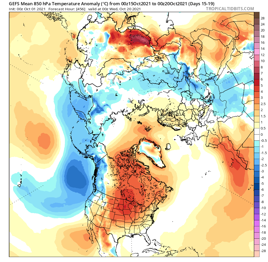
Over North America, we can see the warmer temperatures moving eastward. Much warmer than normal temperatures will continue over eastern Canada. Colder temperatures will be making their way into the western half of the United States, while most of the eastern half of the country will be under warmer conditions and warmer southerly flow.

Precipitation forecast for week 2 in Europe shows drier conditions taking over. The low-pressure area will move into southeastern Europe, producing some precipitation in the area. But most of western Europe will be under a building high-pressure zone, while central regions stay in the drier northerly flow.

We can see wetter conditions forecast over the northern United States and southern Canada. That is due to the low-pressure system entering the western United States. It produces a warm moist westerly/southwesterly flow over the northern United States. Unsettled weather is expected in these regions, while the south-central states are forecast to see less precipitation, as the storm tracks remain further north.
With low-pressure systems entering from the west, a risk of severe weather increases for the south-central states in such setups but depends strongly on many conditions that cannot be forecast 2 weeks out. No indications are currently present for such a scenario.
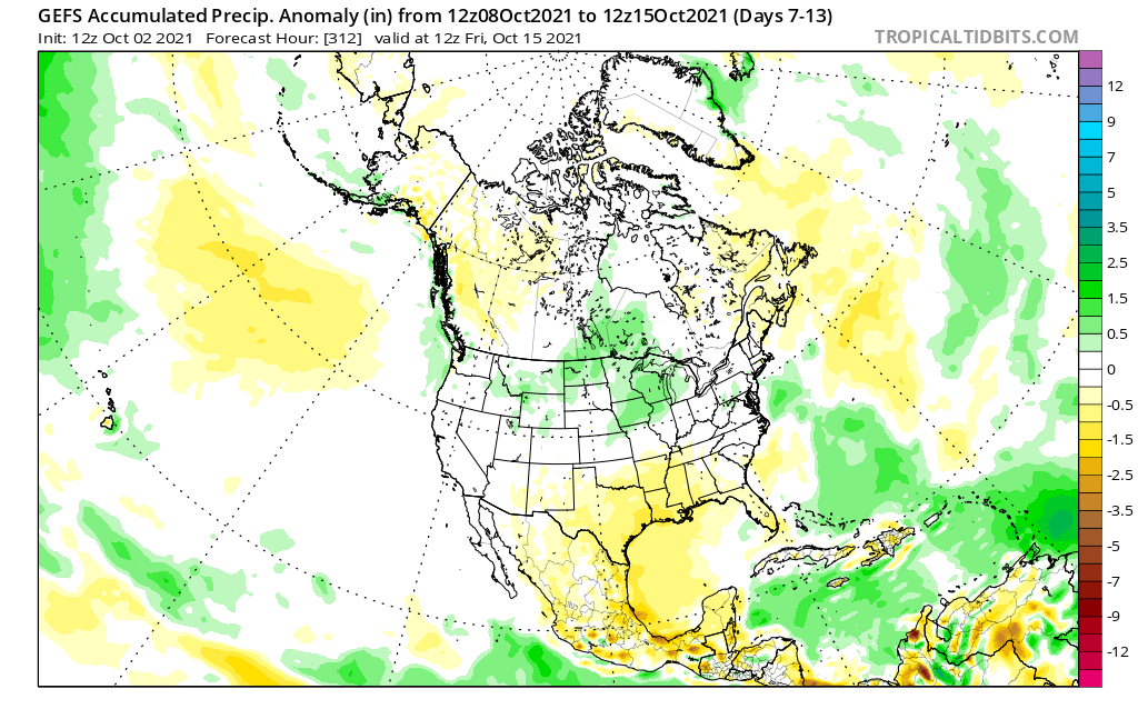
Week 2 summary: Europe will see the low-pressure zone from week 1 move out of central Europe and towards the southeast. In its wake, the drier and cooler northerly flow will prevail over central and parts of eastern Europe. An expanding high-pressure area over western and northwestern Europe will bring warmer and drier weather into those parts.
Taking a quick look at the ensemble forecast for Central Europe, we can see the temperature drop by the end of week 1. It lasts into the middle of the month, before being pushed out by a high-pressure area.

Over the United States, we see a trend of a low-pressure system moving into the western half of the country. It will produce more unsettled weather over the northern half of the United States and southern Canada, with mostly warmer temperatures over the eastern parts. Southern states are expected to have calmer and warmer weather with less precipitation. Still, a risk of severe weather remains for the south-central states in such setups, so the situation will be monitored.
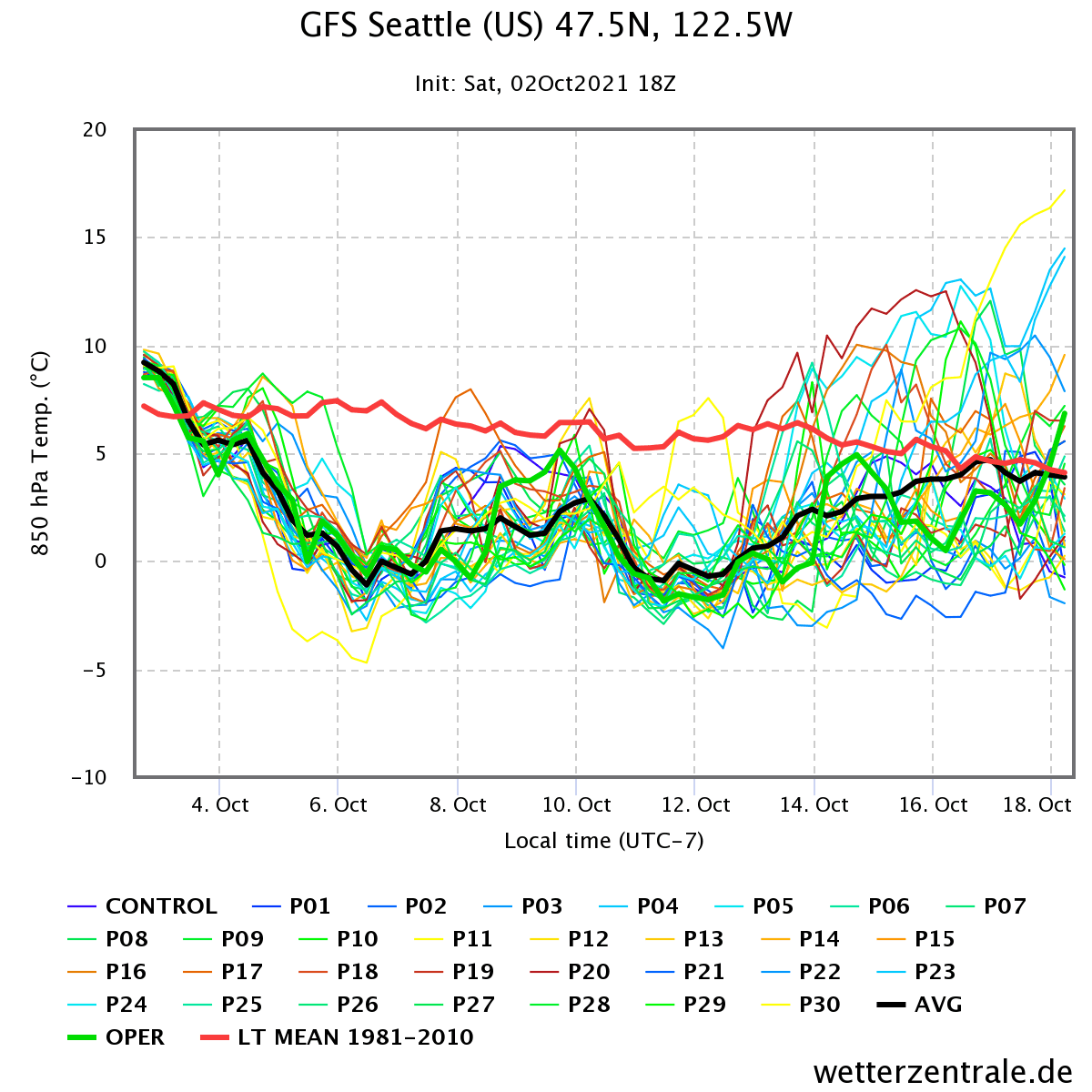
Below we have ensemble forecast graphs for different parts of the United States. In Seattle, northwest United States, we can see a temperature drop as the low-pressure area comes in, but relaxing back up, as the low-pressure area lifts further north.
On the other side of the country, in Chicago, we see steady warmer than normal temperatures under the high-pressure area. But in week 2, temperatures will start to drop, as we have seen the high-pressure area lifting further north, tho still keeping temperatures above normal.

Going to the southwest, we have a forecast graph for Los Angeles, where we see a quite strong temperature drop, as the low pressure moves into the western half of the United States. But towards mid-month, the temperatures will rise again as the low-pressure area lifts back to the north.

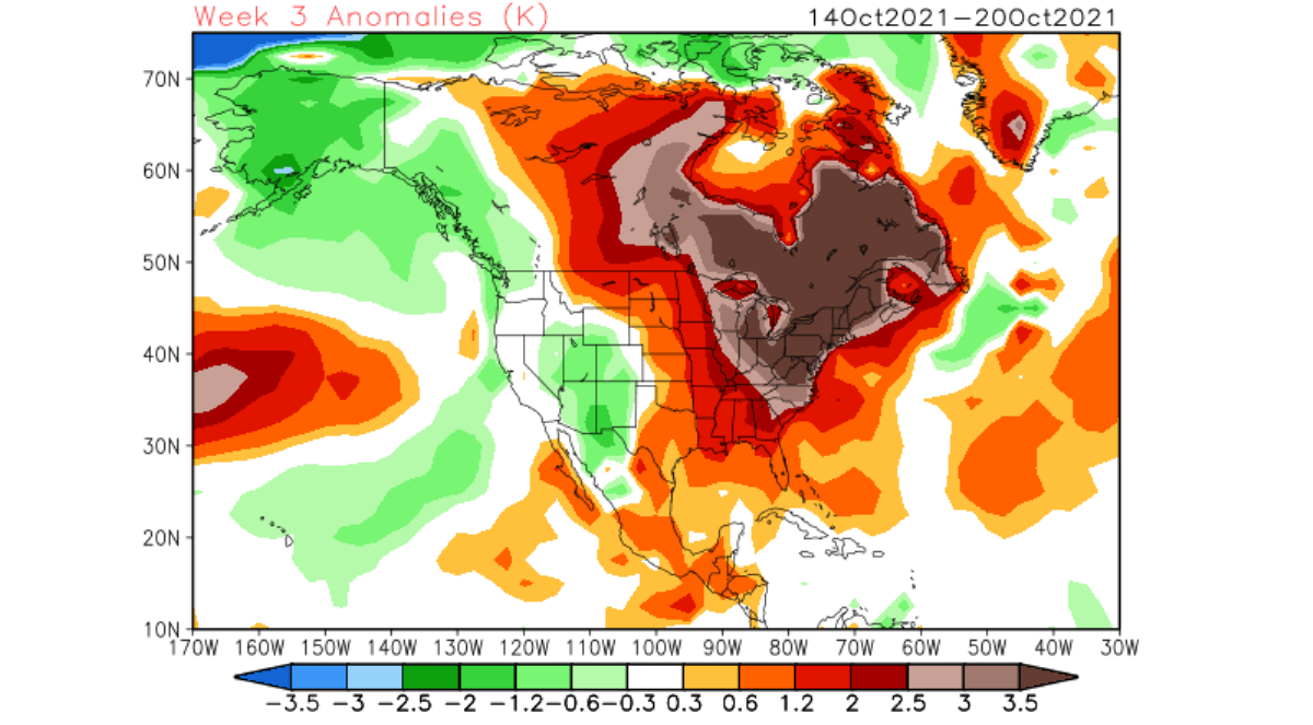
OCTOBER WEATHER – WEEK 3
Going into week 3, we will look at 3 different models. First is the same GEFS model as we looked at for weeks 1 and 2. It shows a similar pattern as in week 2 over North America, but the low-pressure zone over the west seems to back off slightly. The pattern over Europe progresses further, with higher pressure expanding over the mainland, creating a pattern change from previous weeks, as warmer weather again takes over.

Looking broadly over the temperatures, we see that the warmer temperatures have spread into mainland Europe, pushing the colder air further out. Over North America, the warmer temperatures stay over most central and eastern Canada and the northern United States. The colder air is forecast to move out in the west, as the lower pressure area lifts slightly back out.
Adding the ECMWF model, it shows a similar pattern, with higher pressure over mainland Europe and the high-pressure zone over eastern Canada. It features the same low-pressure area over western Canada, but also adds a low-pressure area above Scandinavia.
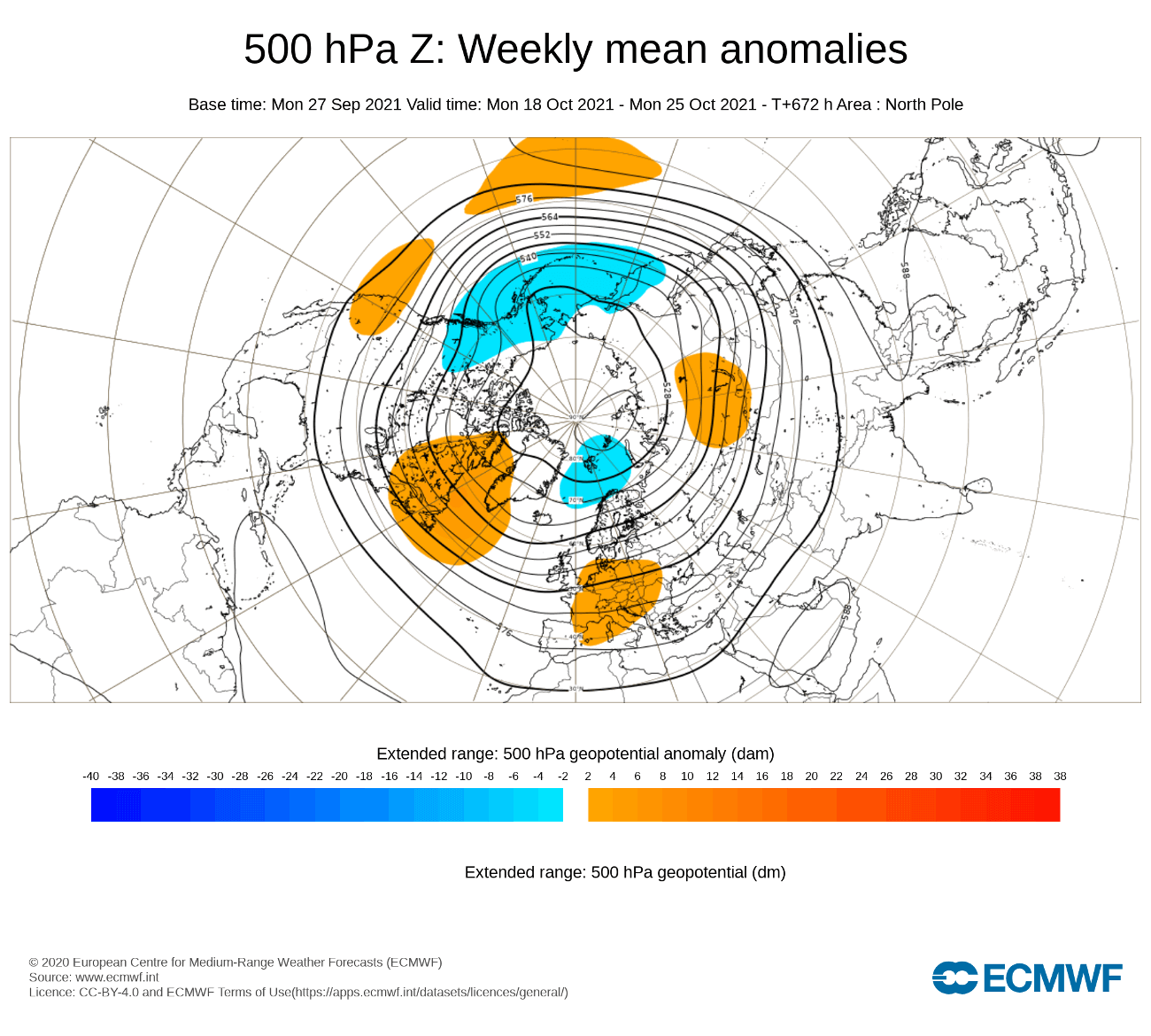
The temperature response is warm weather over western, southern, and parts of central Europe. Colder air is being pushed further to the southeast, just like in the GEFS forecast. Stormier weather is forecast for far northern Europe, due to the presence of a low-pressure area.

Over North America, the ECMWF is forecasting warmer conditions in the western United States and most of central and eastern Canada. However, we see normal temperatures over much of the central and eastern United States, with some cooler conditions hinted at in the southern states. This is likely just due to the long lead time of the forecast, as the forecast gets “washed out”.

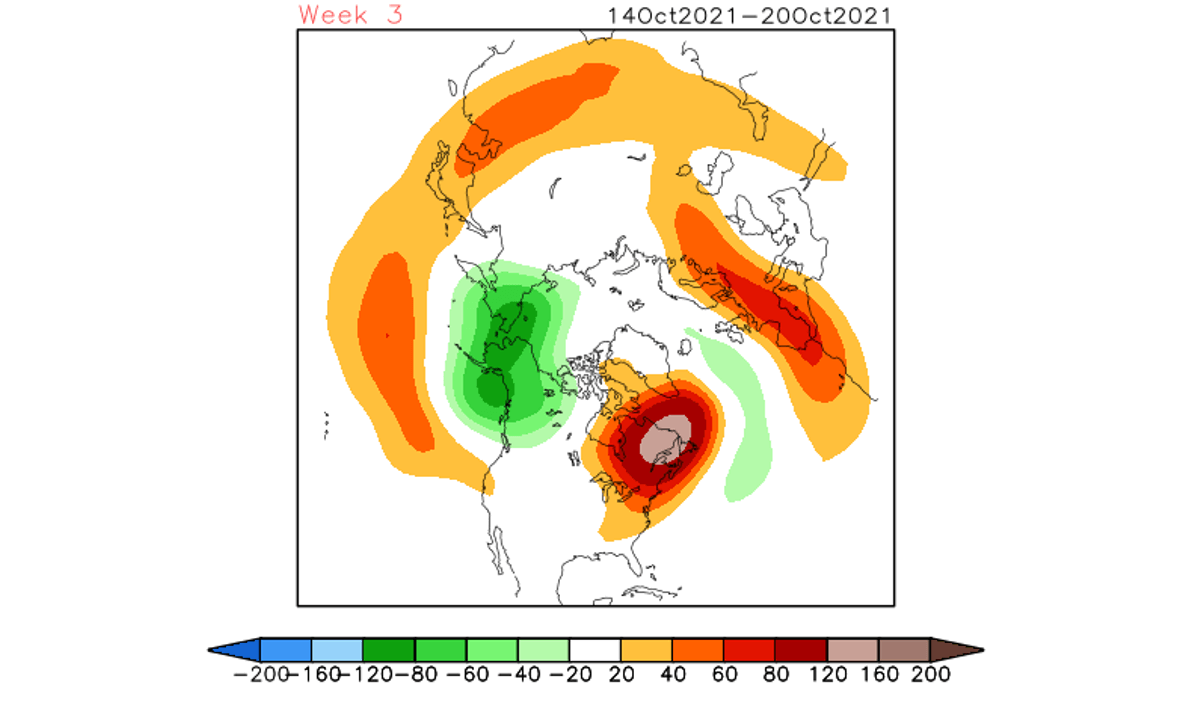
Adding another model is the CFS from the NCEP center in the United States. It also shows the high pressure over mainland Europe and low pressure over Northern Europe. It also has a strong high-pressure area over eastern Canada and a low-pressure zone over western Canada and the Aleutians. So far, the pressure pattern forecast for week 3 is very consistent with all three models.
The CFS model however only has a detailed temperature forecast look for North America, since that is its origin. It is forecasting much warmer than normal conditions over central and eastern Canada and the eastern United States. It keeps some of the cooler air still over the western half of the country.
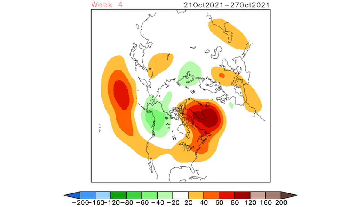
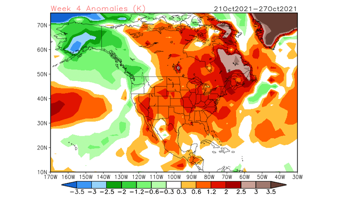
OCTOBER WEATHER – WEEK 4
We will only keep the ECMWF and CFS for week 4, as the GEFS loses most of its signals at this range, which is normal for such ensemble forecasts at this extended range forecast. This range is so far out that we only look at hints of “highs and lows” in the pattern and the strength of the signals and confidence between different models.
For week 4, the ECMWF drops the pattern slightly over Europe, keeping a more westerly flow over central regions, and stable conditions over southern Europe under the high-pressure area.
Over North America we have the high-pressure area moving further over eastern Canada and crawling into Greenland. A low-pressure zone remains over western Canada and over the North Pacific ocean.

Temperature forecast shows the warmer than normal temperatures over western Europe, while central and eastern regions stay mostly normal. This is however a hint that another cooler air intrusion is likely from the north, keeping these regions under a more northwesterly flow.

Over North America, we have a similar pattern than in week 3, keeping most of the western United States warmer than normal. But central and eastern regions stay under normal to cooler temperatures. A transitioning low-pressure system is likely in this region, below the higher pressure further up in eastern Canada.
The CFS model shows a similar story, with high pressure over eastern Canada and extending into Greenland. A lower pressure zone is in western Canada and a weaker one over northern Europe.
The temperature forecast for week 4 of October shows mostly warmer conditions over most of the United States and Canada. The exception is the northwestern United States, western Canada, and Alaska.
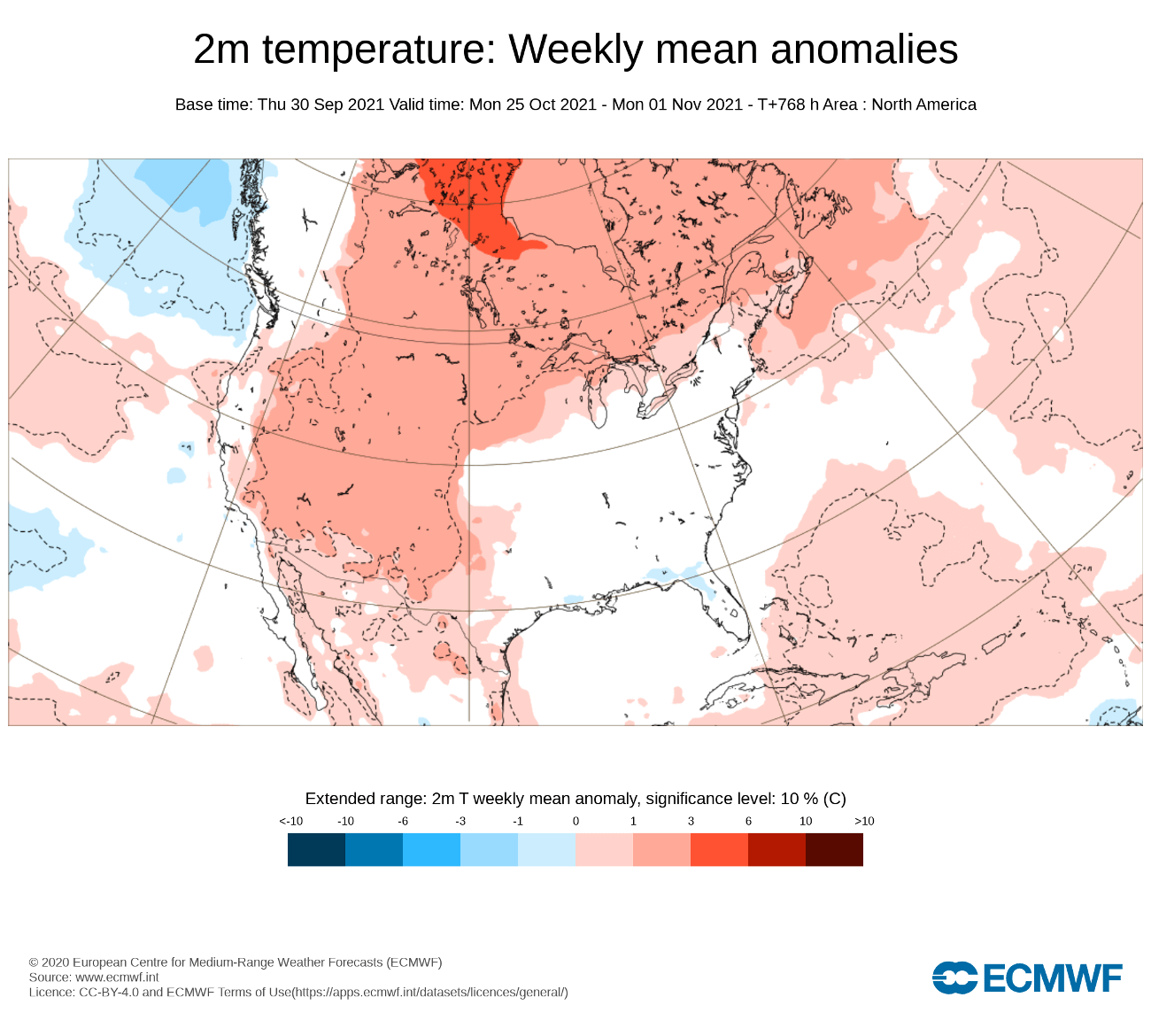
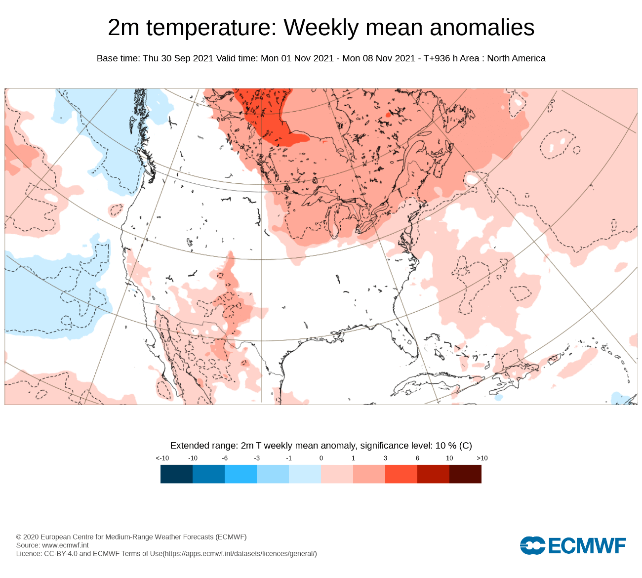
NOVEMBER WEATHER – WEEK 1
Pushing the envelope into week 1 of November 2021, we see the pattern finally changing slightly over North America, and amplifying over Europe. This is a more negative NAO development, with higher pressure crawling over Greenland and low pressure over western Europe and the Azores.

Temperature forecast from ECMWF shows still warmer than normal temperatures over western and north-central Europe, but a pressure pattern with a strong low-pressure area over northeastern Europe can enable a cold drop into central regions, not shown here in the extended forecast, as it is too averaged.
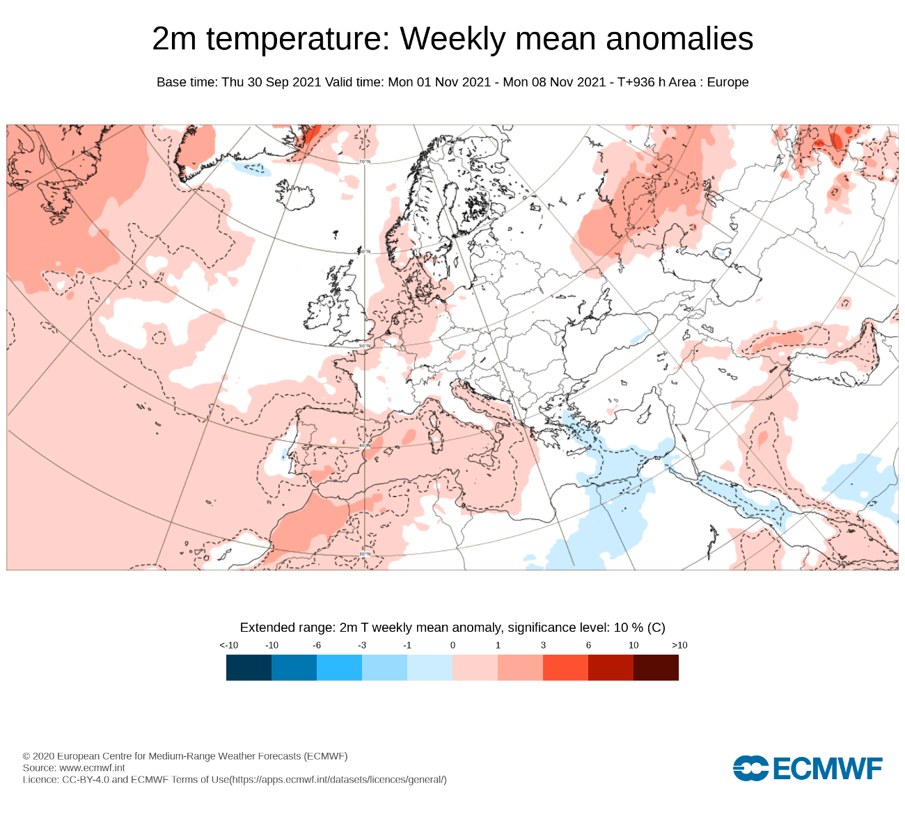
We do see however a change over the United States, as the warmer temperatures are gone from most of the western and northwestern regions. This could indicate a more typical negative NAO pattern, as it allows some colder air transport from western Canada into the northern and central parts of the United States.
We will release regular weekly and monthly updates for the upcoming cold season as fresh forecasts are produced. So make sure to bookmark our page. Also, if you have seen this article in the Google App (Discover) feed, click the like button (♥) there to see more of our forecasts and our latest articles on weather and nature in general.
SEE ALSO: In Siberia, Giant Craters Sparked Dozens of Wild Theories About their Origins. Thawing Permafrost has Shaped the Largest of its Kind, The Batagaika Crater