After the very active and well-above-average Atlantic hurricane season last year, we again forecast that 2022 is likely to be the seventh consecutive above-average season. The first seasonal predictions have been released, and the message is clearly straightforward: Yet another busy hurricane season is expected in 2022. There is also an additional notice in the forecasts, that also an above-average probability for major hurricane landfalls along the U.S. coastline and in the Caribbean is very likely.
The 2022 hurricane season that officially starts on June 1st, is fast approaching. From what we are seeing on the long-term and seasonal charts, it looks like we will face another busy year in the tropics. The majority of the weather model signs that help us predict the number of storms we could expect this year are calling for an active Atlantic hurricane season.
Meaning this will be the 7th straight year having busier-than-normal tropical cyclone activity for the Atlantic Basin and the Caribbean region.
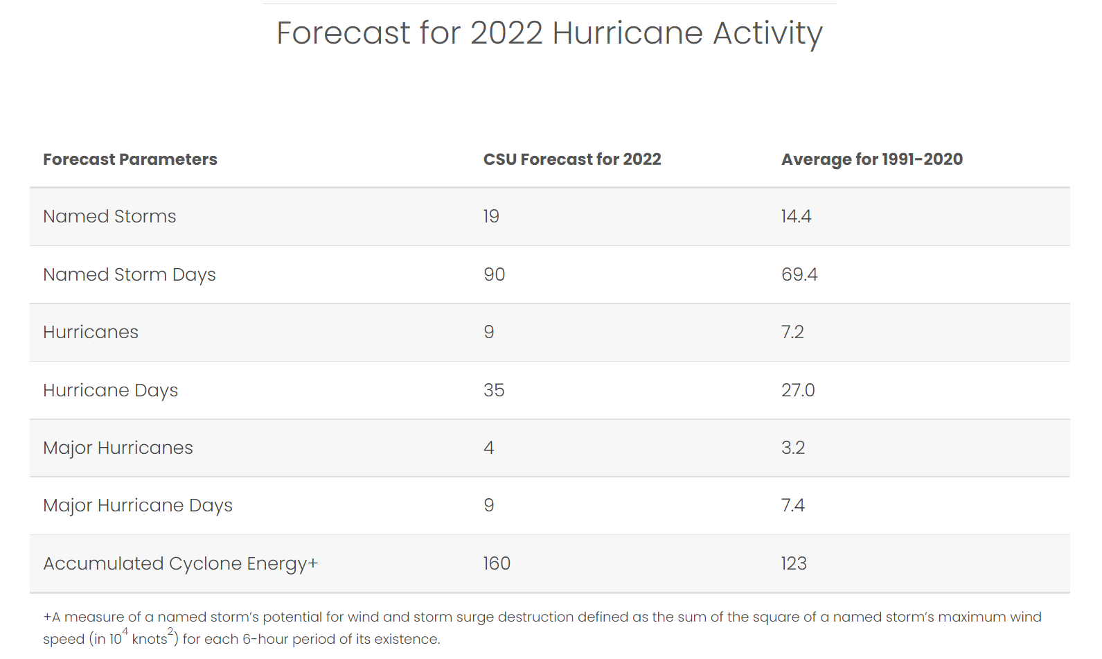
The pre-seasonal forecasts from the Colorado State University (CSU), led by Dr. Phil Klotzbach, hint at about 19 named tropical systems, with 9 hurricanes and also 4 major hurricanes forecast for 2022. That’s well above the 30-year average. On the long-term average, a hurricane season normally brings 14 named storms, seven hurricanes where three of them become of major intensity.
Judging by the pre-seasonal predictions, the Atlantic hurricane season 2022 could be pretty similar to the one we had last year. To keep things on track, the 2021 Hurricane Season produced 21 storms, 7 hurricanes, and 4 major hurricanes. Those major hurricanes were Grace, Ida, Larry, and Sam.
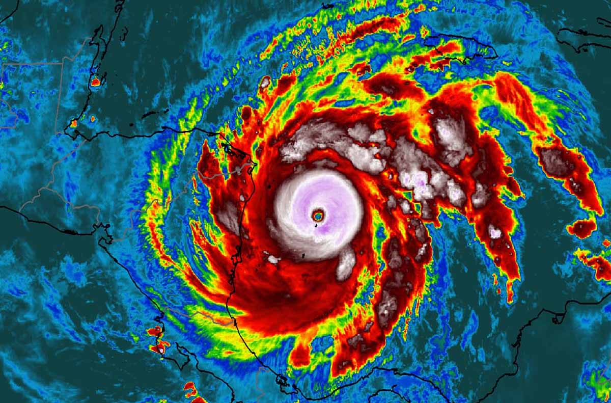
Both 2020 and 2021 seasons were very busy, as we surely remember how 2020 brought a record number of 30 named storms, breaking so many records it was hard to track everything at times. One example of how intense storms developed that year can be seen in the image below.
This is an infrared satellite view of a Category 5 hurricane Iota in mid-November 2020. Last year, for instance, ended with 21 named storms, again much above the long-term average.
Officially, the Atlantic hurricane season runs from June 1st through November 30th. The Atlantic basin covers the tropical area which includes the entire Atlantic Ocean, the Gulf of Mexico, and the Caribbean region. The long-term average (taken over the last 70 years, that is between 1951 and 2020) holds 11 named storms in one full hurricane season. At the same time, the short-term average (taken over the last 15 years, so between 1995 and 2020) is higher, with around 14 named storms.
Similar to the 2020 and 2021 years, the re-merging La Nina global weather pattern, combined with well-above-average Atlantic seawater temperatures, the upcoming hurricane season is expected to be busy. These warmer than normal water temperatures are also observed across the Caribbean and the Gulf of Mexico. Although the tropical Pacific Ocean waters were gradually warming into neutral ENSO conditions during the recent cold season, the La Nina is expected to develop and intensify through the late summer months this year.
Long story short, La Nina will lead to yet another busy Atlantic Hurricane Season.
The video animation above represents the tropical region sea temperature anomaly over the last couple of months. We can see how cooler the Pacific waters are developing, meaning La Nina is gradually gaining strength. At the same time, most of the Atlantic, the Caribbean, and the Gulf are quite warmer than normal, including across the region known as MDR (the main development region – between Africa and the Caribbean Sea). This hints to us that upcoming tropical cyclone formation will fuel from the very warm ocean waters when hurricane season starts.
A hurricane organizes and gains its strength when specific weather conditions are met. Normally, hurricanes need to have a low-shear environment with a lot of very warm sea waters, resulting in plenty of very moist air mass above the sea. During La Nina years (negative ENSO phase), its related global circulation helps those to maintain and develop.
One of the more eye-catching parts of the seasonal forecast for the upcoming hurricane season is the much higher than 70% chance of a major hurricane landfall along the United States coastline, as well as in the Caribbean. Remember, that a typical season has about a fifty-fifty probability of the US mainland getting hit. This is something to consider and always be hurricane aware of as we enter the new Atlantic hurricane season in just about two weeks and a half from now.
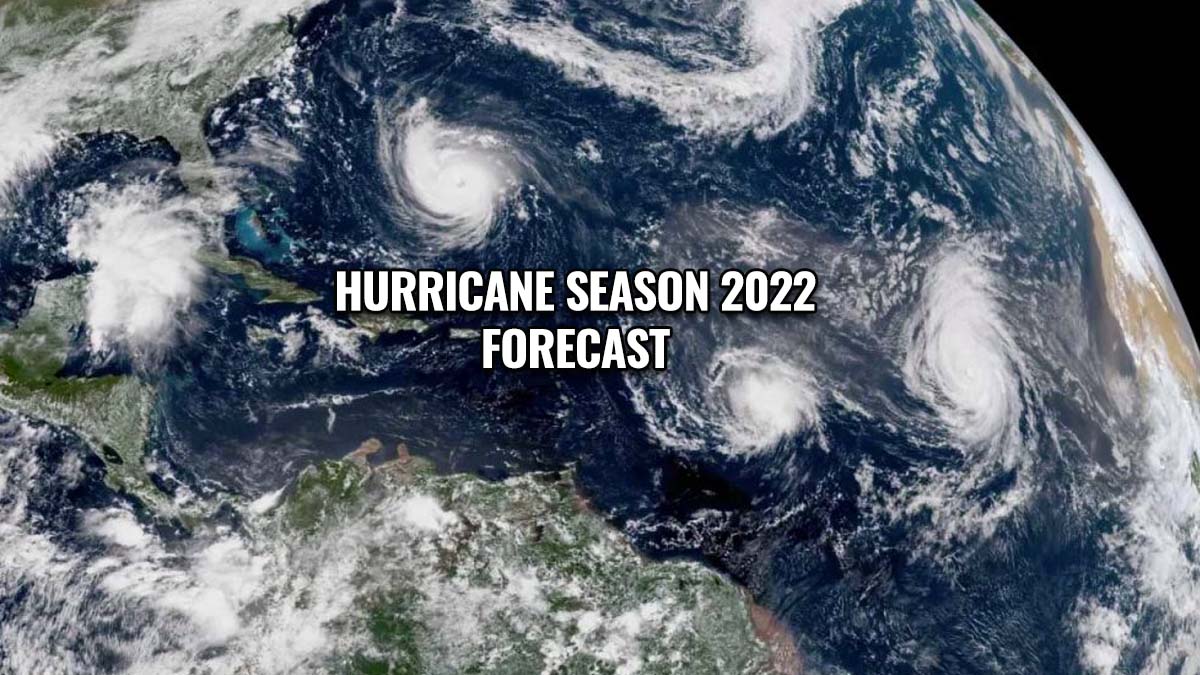
ATLANTIC HURRICANE SEASON LAST YEAR WAS VERY ACTIVE, COULD IT REPEAT IN 2022 AGAIN?
If we remember the 2020 Atlantic hurricane season, it was so historic, that we should take it as an anomaly in the statistical records. However, the pre-seasonal forecast for 2022, is quite similar to what we have seen during the hurricane season last year, 2021. We could expect something similar also later this year, in both numbers of storms, the intensity of hurricanes, and major hurricane landfalls.
Below are the designated names reserved for the 2022 Atlantic hurricane season, these include 21 names starting with Alex and ending with Walter. If eventually, more than 21 storms end up developing, that means forecasters will have exhausted the designated tropical cyclone list for the third consecutive year. A supplemental list then comes into use.
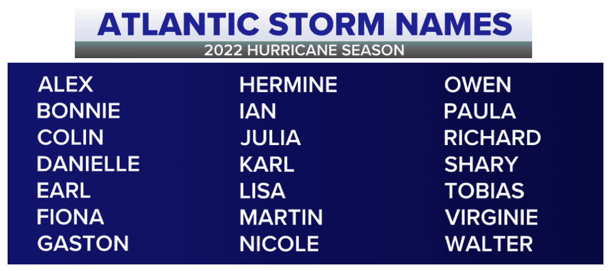
The Atlantic tropical cyclones had been named from lists originated by the National Hurricane Center, in use since 1953.
Tropical cyclone names for the Atlantic Hurricane Season are maintained and updated by an international committee of the World Meteorological Organization. The hurricane name lists are used in rotation and are re-cycled every six years. This means that the list used in 2022 will be used again in 2028.
With CSU predicting an above-average number of tropical storms and hurricanes this year, also the ACE index is forecast to be very high. ACE is known as the Accumulated Cyclone Energy – in other words, how much energy storms produce. The CSU predicts an ACE of 160, which is well above the average for a hurricane season.
What is an ACE index – Accumulated Cyclone Energy?
The Accumulated Cyclone Energy (ACE) is basically a metric that is used to express the energy used by a tropical cyclone during its life cycle. The index calculation takes a tropical cyclone’s maximum sustained winds every six hours and multiplies it by itself to generate the values.
So the total sum of these values is calculated into the total value for a storm and can either be divided by 10,000, this makes them more manageable. The sum could also be added to other totals in order to work out a total for a particular group of storms.
The calculation of the ACE index was originally created by William Gray and his associates at Colorado State University as the Hurricane Destruction Potential index. This index took each hurricane’s maximum sustained winds above 65 knots (120 km/h = 75 mph) and multiplied it by itself every six hours. It was then subsequently tweaked by the NOAA in 2000 that it now includes all tropical cyclones, with winds above 35 knots (65 km/h = 40 mph) and renamed to Accumulated Cyclone Energy we know today.
For the Atlantic Ocean, the NOAA uses the ACE to classify hurricane seasons into four categories seen below.
Extremely active – ACE index above 152.5
Above-average – ACE index above 111
Near-average – ACE index between 66 and 111
Below-normal – ACE index below 66
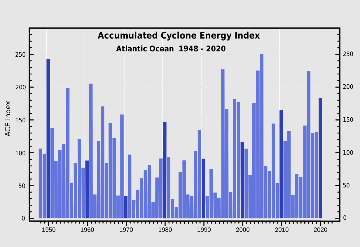
To better imagine how it works, we can take a look at the 2020 Atlantic hurricane season. It ended up at 184.5 ACE, so quite well above the threshold for the ‘extremely active’ category as we can see. This placed 2020 into the Top-10 Atlantic hurricane seasons based on the Accumulated Cyclone Energy index.
However, the record holder hurricane season remains 1933, which had an ACE of more than 258. The next one with high ACE was the 2005 hurricane season, the one with the 2nd most named storms after 2020. Its ACE index ended up extremely high, at 250.
So we can easily see that, although the 2020 hurricane season was so extremely active and had a record-breaking number of tropical cyclone formations and hurricanes, it doesn’t necessarily mean the Accumulated Cyclone Energy would be off the charts as well. The closest hurricane season to the ‘extremely active’ category in recent years was actually last year. 2021’s ACE ended at 145.1.
Remember, that many of those well-above-average years happened during the La Nina years. We can find many of those in the last 20 years, 2021, 2020, 2017, 2010, 2008, and 2005, all happening during colder than normal ENSO years.
Note: We use ENSO as an abbreviation for El Niño Southern Oscillation, a periodic variation in winds and sea surface temperatures over the tropical eastern Pacific Ocean. It affects the climate of much of the tropics and subtropical regions around the world.
WARM TROPICAL ATLANTIC TO FUEL EARLY STORMS, CONTINUE INTO PEAK HURRICANE SEASON
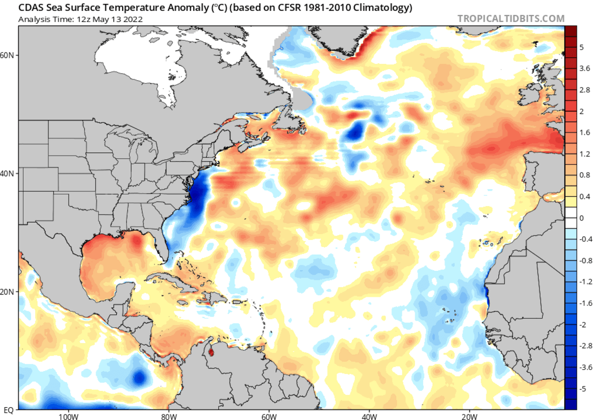
As of mid-May, much of the Atlantic Basin is already warmer than normal, particularly across the Gulf region and the Caribbean. A large part of the Gulf of Mexico is actually much warmer than average, that is why are seeing so high moisture advecting into the Great Plains and Midwest, resulting in severe weather events recently.
Also the tropical central and western Atlantic regions and near to slightly above normal. This perfectly correlates with what is typically seen prior to active Atlantic hurricane season. We expect that these waters will be sufficiently warm enough to support significant tropical development during the peak of the hurricane season from mid/late August into September.
Often our eyes are watching the weather in western Africa. That is where the tropical waves emerge into the eastern Atlantic Ocean. Nearly 85% of these waves lead to organized deep convection over the warmer oceans and become tropical depressions or storms.
Winds are forecast to be strong in western Africa again this year, so expectations are we will see a number of tropical waves traveling west.
LA NINA WILL LEAD THE PEAK MONTHS OF THE ATLANTIC HURRICANE SEASON 2022
We seriously cannot go by the Atlantic hurricane season when there is the La Nina global circulation in play. Its well-known influence leads to different atmospheric conditions. Normally boosting the activity and the number of tropical systems, including more intense, major hurricanes of a Category 3 or greater.
The following image below indicates the tendency for more hurricanes in the Atlantic Basin. This is because the vertical wind shear is lower and the atmosphere is more unstable. In contrast, there are fewer hurricane developments in the eastern Pacific region, as stronger wind shear is present.

Starting from the basics, the El Niño Southern Oscillation (ENSO) is a region in the eastern tropical Pacific ocean. It alternates between cold and warm phases. The tropical trade winds (those are the easterly winds that circle the Earth near the equator) usually initiate or stop a certain phase, as they mix the ocean near-surface waters and alter the ocean currents.
The periodic cooling of the tropical eastern and central Pacific oceans is known as La Niña, occurring when sea surface temperatures are cooler than average by at least 0.5 °C.
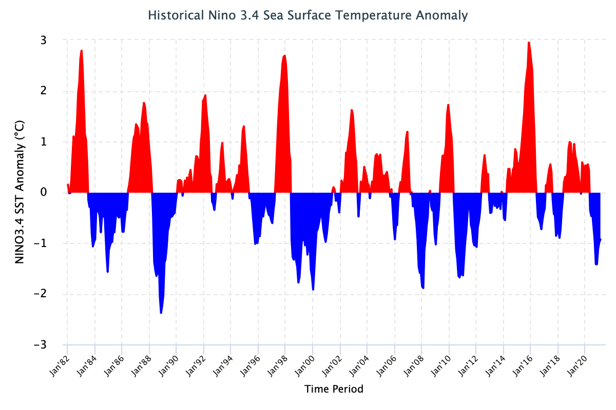
The opposite, the warm phase, is known as El Nino. Each of these two ENSO phases has a different influence on tropical weather and how it impacts the weather worldwide. Speaking of the influence on the Atlantic Basin hurricane season, La Nina is more often a booster, while El Nino keeps the activity lower than normal.
So, as we discussed in one of our recent articles in detail, the latest ocean temperature forecast for the Hurricane season shows the active cold anomalies in the ENSO region. So besides this, the other very important ingredient is the seawater temperature across the tropical Atlantic, the Caribbean region, and also the Gulf of Mexico.
The forecast calls for near to above-normal seawater temperatures from August to October 2022.

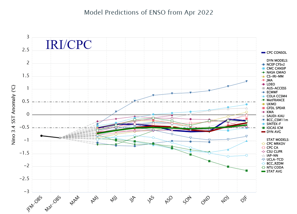
The recent IRI forecast chart of the ENSO for 2022 hints that the cooler tropical Pacific will continue and strengthen through the summer, extending through the peak of the Hurricane Season.
With the most recent NOAA’s latest ENSO outlook, there are reduced odds of El Nino and increased odds of La Nina for the Atlantic hurricane season peak.

Having colder than normal central Pacific waters as we see below, typically means that the Atlantic hurricane season becomes active, potentially even very active. Let’s not forget the 2020 and 2021 seasons again.
Those were the textbook years with a combination of strong La Nina (actually 2020 it was the strongest in the last 10 years) and very warm Atlantic sea temperatures throughout most of the hurricane season.
According to dr. Phil Klotzbach, the Colorado State University (CSU) predicts 19 named storms with the Atlantic hurricane season 2022. That is 32 percent (4.5 named storms) more than an average hurricane season. The climatology data takes the period between 1991 and 2020.
Basically, all the parameters that are typically monitored during the hurricane season are likely to be much above average again this year. CSU predicts about 90 named storm days (30 % above average), 9 hurricanes (25 % above average), and 4 major hurricanes (25 % above average). The Accumulated Cyclone Energy (ACE) could reach 160 which is 30 % above the normal for the 1991-2020 period.
As we can see, the group of forecasters, led by dr. Klotzbach is again forecasting a very serious outcome of the upcoming Atlantic hurricane season, similar we could see and also verify in the recent two seasons. So residents of the coastal areas should always be hurricane aware once we are past the official start on June 1st, no matter the forecast.
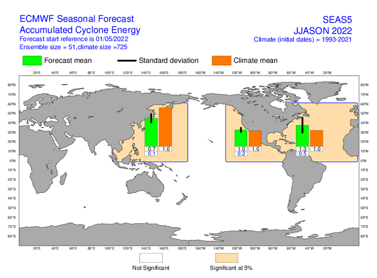
The recent ECMWF model forecast for Accumulated Cyclone Energy (ACE) hints at an above-normal forecast for the Atlantic hurricane season. This could actually mean two possibilities: Either a higher number of generally intense tropical systems or a few major hurricanes that can quickly boost ACE.
As we learned, the Accumulated cyclone energy (ACE) is generally a metric that expresses the energy of a tropical cyclone during its lifetime. Thus, we can combine the total energy from all tropical systems to compare different seasons. It is then easier to see which has been more active. However, this does not tell us much when it comes to landfalls.
Statistical records do tell, that an Atlantic hurricane season with low total ACE can have 2-3 hurricane landfalls in the United States. But there could be a high-ACE hurricane season which includes a higher number of storms, but those could mainly stay out in the open waters. So there is no clear correlation.
To conclude, the lack of warmer central tropical Pacific waters is surely a great concern, as forecast numbers are calling for the well-above-average to potentially even extremely active Atlantic hurricane season 2022.
HURRICANE EMERGENCY KIT
Anyone living in the areas with the potential to get affected by hurricanes needs to have a so-called Hurricane Emergency Kit. Let’s see what you need to have in your plan. Everything that is needed if the event an emergency happens, can be packed up in what is called a go-bag. This includes nonperishable foods, water, flashlights, and batteries are the more obvious things.
But the first thing that goes in is the paperwork, e.g. personal ID, prescriptions, and titles to homes and cars. The list should also include a battery-powered radio, face masks, even a whistle to call for help, ponchos, and emergency blankets.

When we have a hurricane forecast to impact, there are multiple steps for those living in apartments can take in order to be prepared for when a hurricane strikes. Get to talk with building management about an evacuation plan. Those will tell you how to get out and where to go, this will save you time during an emergency.
When hurricane strikes occur, losing power and access to elevators brings issues, especially for high-rises. Therefore, we need to stock up with food and water for a few days. If you could not get out of the building, you have to be prepared. Also, have extra batteries for phones and electronics.
Higher buildings have another issue, that’s the intense winds. Bring outdoor furniture, be sure to lock your windows, and most importantly, stay away from windows. If your apartment is very near or below ground level, there is only one plan: get out and leave for higher ground. Storm surges will bring floods.
Our expert forecast team will be actively following the tropical region activity worldwide, including Atlantic Basin systems and tropical cyclones that are likely to affect both the United States and Europe again in 2022. Stay tuned for further follow-up posts, in-depth forecast discussions, and nowcasting during the coming weeks and throughout the upcoming Atlantic hurricane season 2022. We will make you prepared.
Don’t forget to bookmark our page to have all the new info ready at hand at any time. Or click on ‘show more’ if you are reading this article from the Google Discover feed.
Images used in this article were provided by Tropical Tidbits and NOAA.