In the coming weeks, the weather patterns will readjust, creating near Summer-like conditions in the parts of the United States. Parts of western and central Europe will also feature warmer than normal weather, as a high-pressure zone extends over.
One key aspect of this weather forecast story is the jet stream. It connects the pressure systems across the hemisphere, helping to shape our daily weather.
In a short amount of time, you will learn what exactly the jet stream is, and how it is a key component in any major global weather dynamic. And also, you will see how the re-adjusting weather patterns bring almost summer weather to the first half of the month.

JET STREAM AND WEATHER PATTERNS
The jet stream is a large and powerful stream of air (wind) at around 8-11km (5-7mi) altitude. It flows from west to east around the entire Northern Hemisphere, affecting pressure systems, and their strength, thus shaping our weather at the surface.
It is driven by the temperature difference between the cold polar regions and the warmer tropics. It flows from west to east due to the rotation of the Earth.
In the image below you can see a simplified visualization of the global jet stream. The polar jet stream is more important during the cold season, while the subtropical jet stream plays a bigger role also during the warm season.

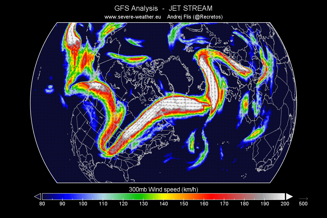
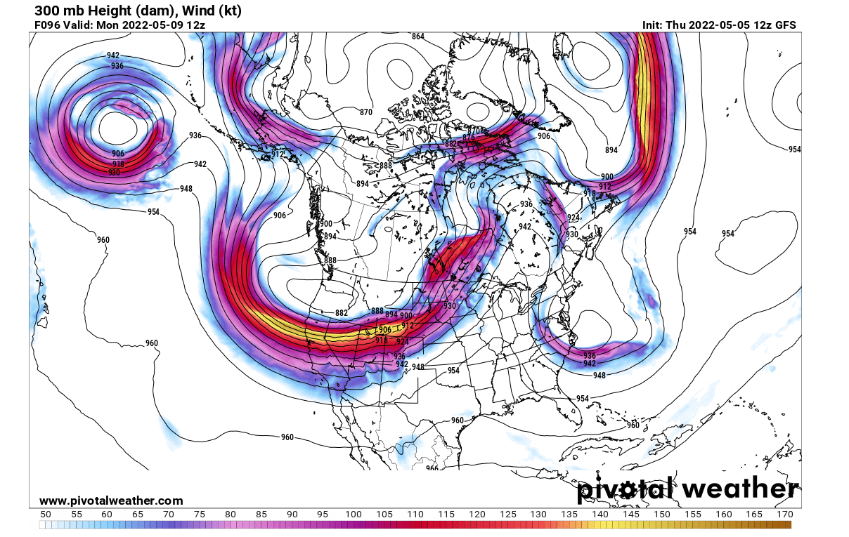
Below is an example of the winter jet stream at 300mb (9km/5.6mi altitude). In this example, the jet stream is quite curved down over the central United States, which brings colder air down from the north. It is bending upwards over northern Europe. Such formation brings warmer weather to Scandinavia and stormy conditions to Iceland and the British Isles.
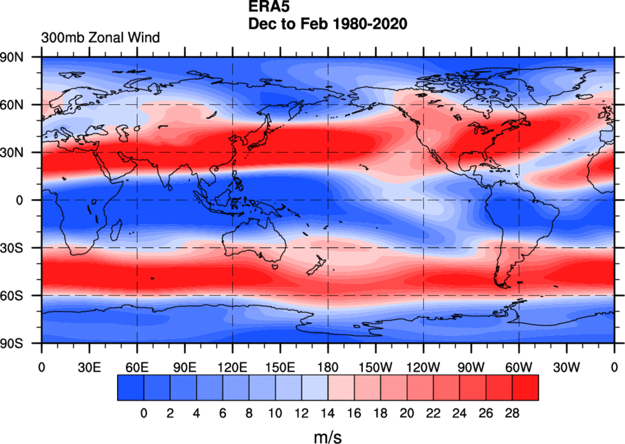
Below we have a winter westerly wind analysis for the past 40 years, from ECMWF reanalysis data. It highlights the westerly winds at the 300mb level (9km/5.6mi altitude).
You can see the strong winter jet stream around the Northern Hemisphere, driven by the temperature difference between the cold polar regions and the warm tropics.
But in summer, you can see below that the jet stream is much weaker and further to the north. It sits on the United States-Canada border during the summer season.

But the jet stream is just another part of the complex atmospheric weather system. It can be changed in several ways, from large-scale dynamics like the Polar Vortex or the ENSO.
ENSO is the region of the tropical Pacific Ocean, that shifts between warm and cold phases. It changes the pressure patterns in the tropics and the subtropics, affecting the global weather.
Comparing the two phases of the ENSO in the image below, we can see that they typically produce an entirely different winter weather pattern across North America, by changing the position of the jet stream.

La Nina (cold phase) features a stronger and extended polar jet stream from Alaska and western Canada into the United States. But the El Nino (warm phase) features a stronger subtropical jet stream and an amplified storm track over the southern United States.
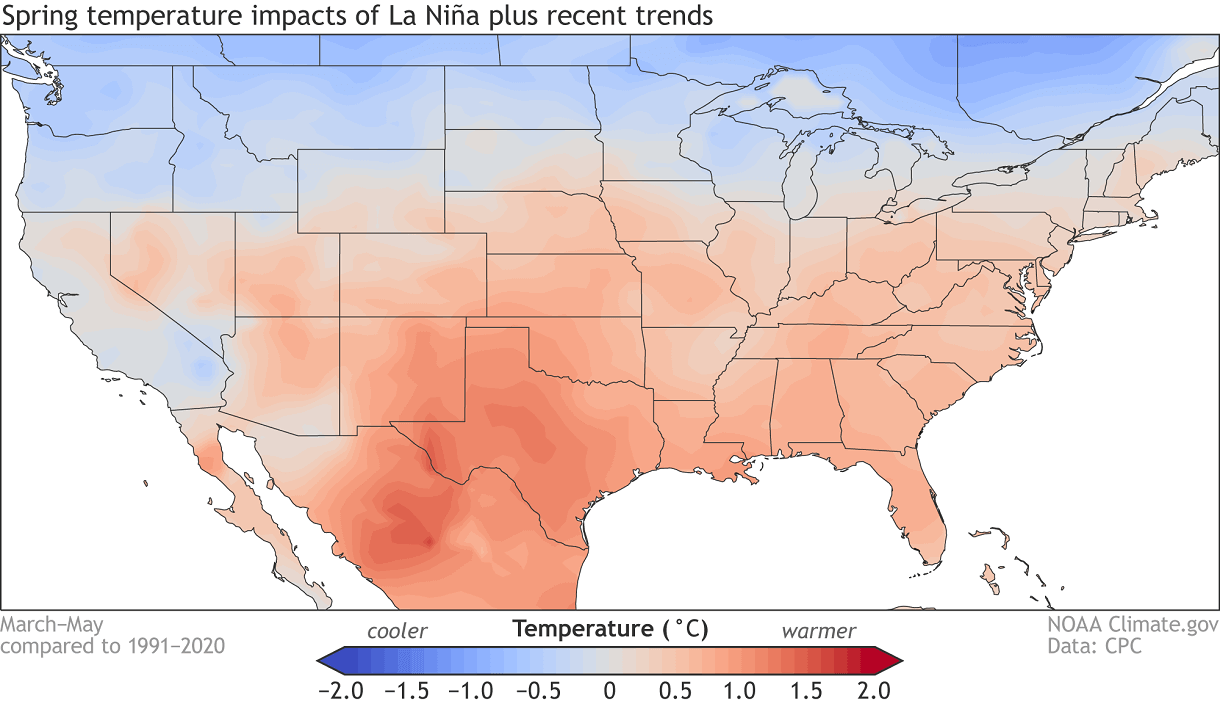
We are currently in a La Nina cycle. And below we have the average spring temperature impact of the La Nina. It promotes a stronger jet stream over the north/northwest, keeping the northern United States cooler and the south warmer than normal.
POLAR CIRCULATION
Above, we mentioned the Polar Vortex as another major factor in the weather development. In the warm season, this is meant as the polar circulation, which can be either strong or weak.
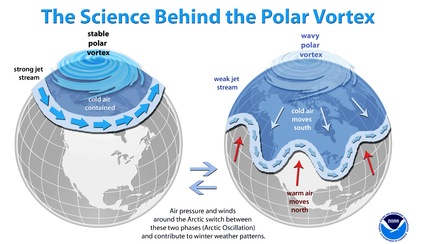
A strong Polar Vortex usually means strong polar circulation thus a strong jet stream. This usually locks the colder air into the Polar regions, creating warmer conditions for most of the United States and Europe.
In contrast, a weak Polar Vortex can create a weak jet stream pattern. It has a much harder time containing the cold air, which can now escape out of the polar regions, into the United States and/or Europe. Image by NOAA.
The strength of the lower Polar Vortex and its influence can be tracked by the Arctic Oscillation (AO) index. It basically tells us if the polar circulation is strong or weak.
This March, there was a special event occurring in the stratosphere, with a warming event and the buildup of high pressure. It broke down the polar vortex.
In the image below we can see the pressure anomalies in the upper levels and in the stratosphere. Notice low-pressure anomalies during the winter and a strong AO index.

In late March, we had the polar vortex breakdown, and the AO index went into a negative phase for most of the time since. But now this event is ending its influence, and we are expecting a new pattern to stabilize towards Summer.
We produced a high-resolution video, which shows the recent collapse event of the Polar Vortex. We can see the Polar Vortex first being split apart, followed by a strong displacement and disintegration. This is what caused the weak polar circulation in the past weeks.
Below we have the AO index forecast, and it shows a strong positive phase is developing for at least the next two weeks. This supports warmer conditions across the United States and Europe.

But we are now going to “zoom in” even more, and analyze a more local weather pattern over North America. It is a unique region, linking the influence of the polar regions and the more direct oceanic influences.
PACIFIC-NORTH AMERICAN WEATHER PATTERN
Pacific North American index (PNA), explains the pressure pattern over North America. A negative phase means lower pressure over western Canada and the western United States, and the positive phase indicates a high-pressure buildup over the western United States and Canada.
Below are examples of the positive and negative phases of the PNA. It shows quite a different pattern, linked also nicely with the Arctic Oscillation and the ENSO influence from the Pacific Ocean.

Below we have the PNA index forecast. It shows a shift into the negative phase. Combined with the positive AO forecast above, it supports the jet stream over the western United States and warmer weather in central and eastern United States.

The negative phase of the PNA pattern is associated with a weaker jet stream across the central Pacific Ocean. High-pressure “blocking” of atmospheric flow in the high latitudes of the North Pacific is common, and a split-flow of the jet stream over the central North Pacific.
Below we have an example of the average pattern during a negative PNA phase in the past 40 years. We can see warm anomalies in most of the southern half of the country. Of course, individual cases can vary greatly, but it shows a warm tendency.

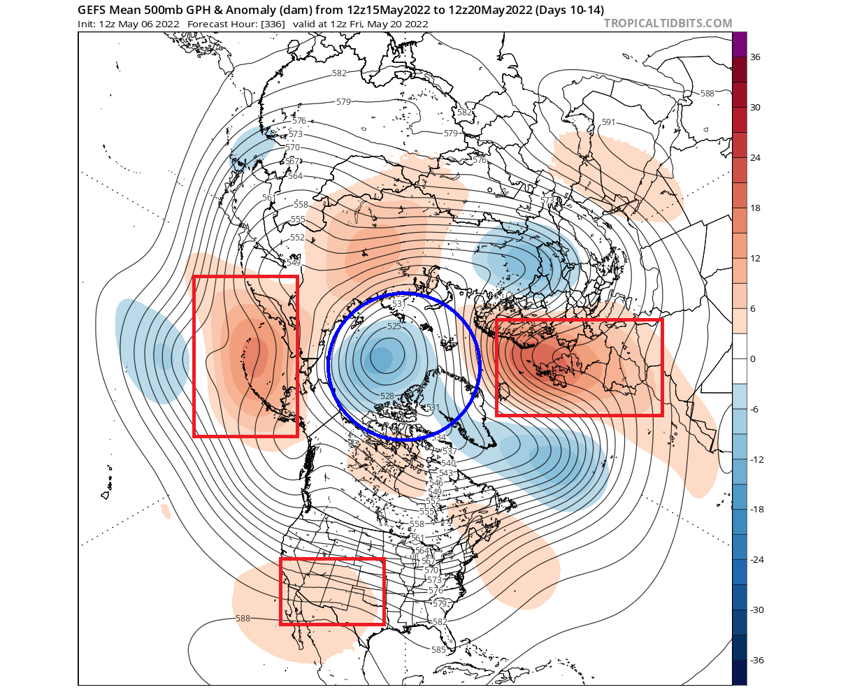
Looking at the jet stream forecast for early next week, we can see the jet stream over the western United States, around a low-pressure system in the northwest. This pattern builds a ridge over the southern and eastern United States, bringing up warmer weather.
CURRENT WEATHER PATTERN
Looking at the current weather pattern below, we have two main areas of interest. We can see the positive AO index over the polar regions, with the building low-pressure zone. That gives room for a high-pressure system to expand into Europe.

The second area of interest is in the North Pacific and western Canada. We can see a large low-pressure area descending down. It is set to enter western Canada and the western United States in the coming days. This is the typical negative PNA weather pattern.
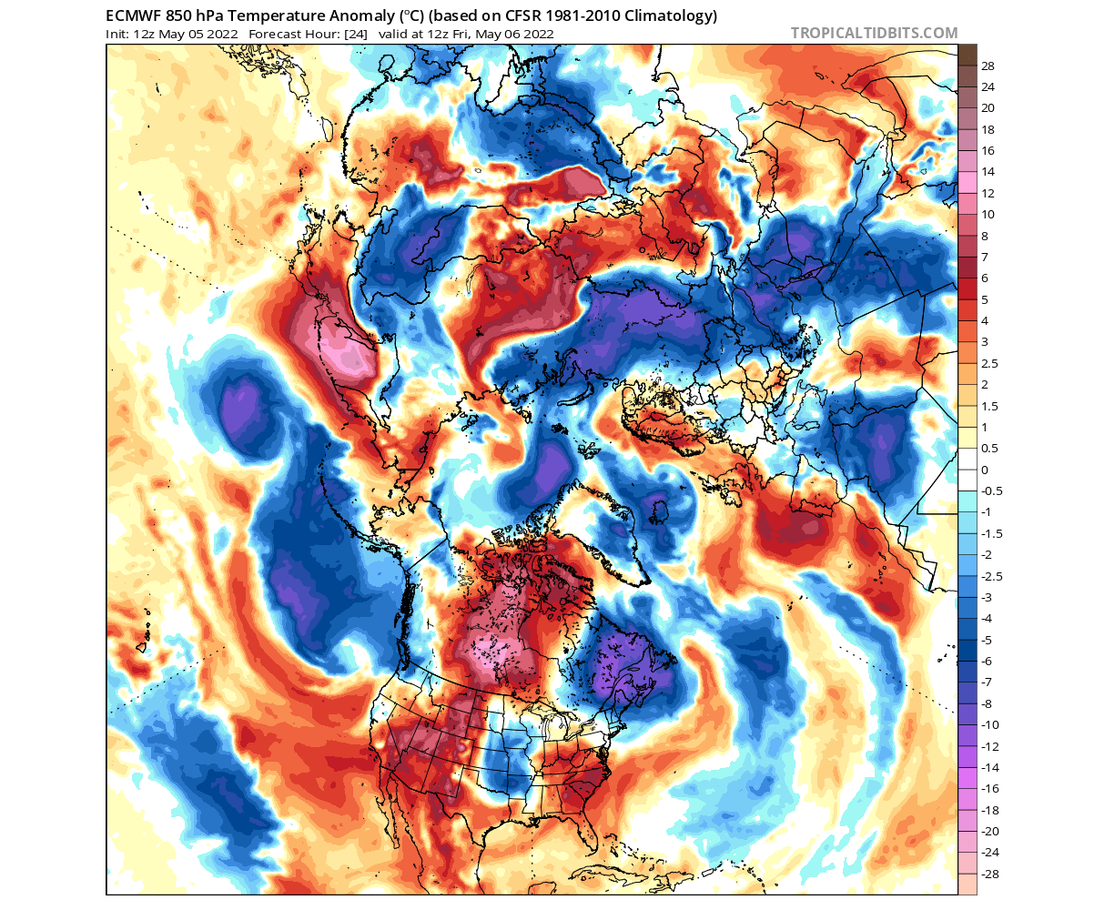
Looking at the current temperature anomalies, we can see mixed north-south anomalies over Europe. Over North America, we have warmer weather over the western and eastern United States, and warm anomalies in central Canada. Cold anomalies prevail in eastern Canada.
Looking closer at surface temperatures, the latest data shows warmer than normal weather in the western and southeastern United States. A low-pressure system is currently passing over the south-central United States towards the east, bringing cooler temperatures in its wake.

Going ahead, the weather forecast shows the negative PNA index to take over big time, creating unseasonably warm weather across much of the central and eastern United States.
1-6 DAY FORECAST
The weather pattern in the next few days is going to take a step forward over North America and Europe. A high-pressure ridge continues to expand over Europe from the west. But a strong ridge will also build over the central United States up into eastern Canada.

The low-pressure system descends further down over the northwestern United States. It is bending the jet stream, driving the southerly winds, and pushing a ridge over the central and eastern United States.
This pattern can be seen creating warmer conditions over western and parts of central Europe. But the main warm weather push comes with the ridge over the United States and Canada. Colder than normal temperatures return to the west coast.

Taking a closer look at the United States, we can see the colder than normal temperatures spreading over the western and northwestern United States. Ahed of the low-pressure system in the southerly flow, we can see expanding unseasonably warm temperatures.

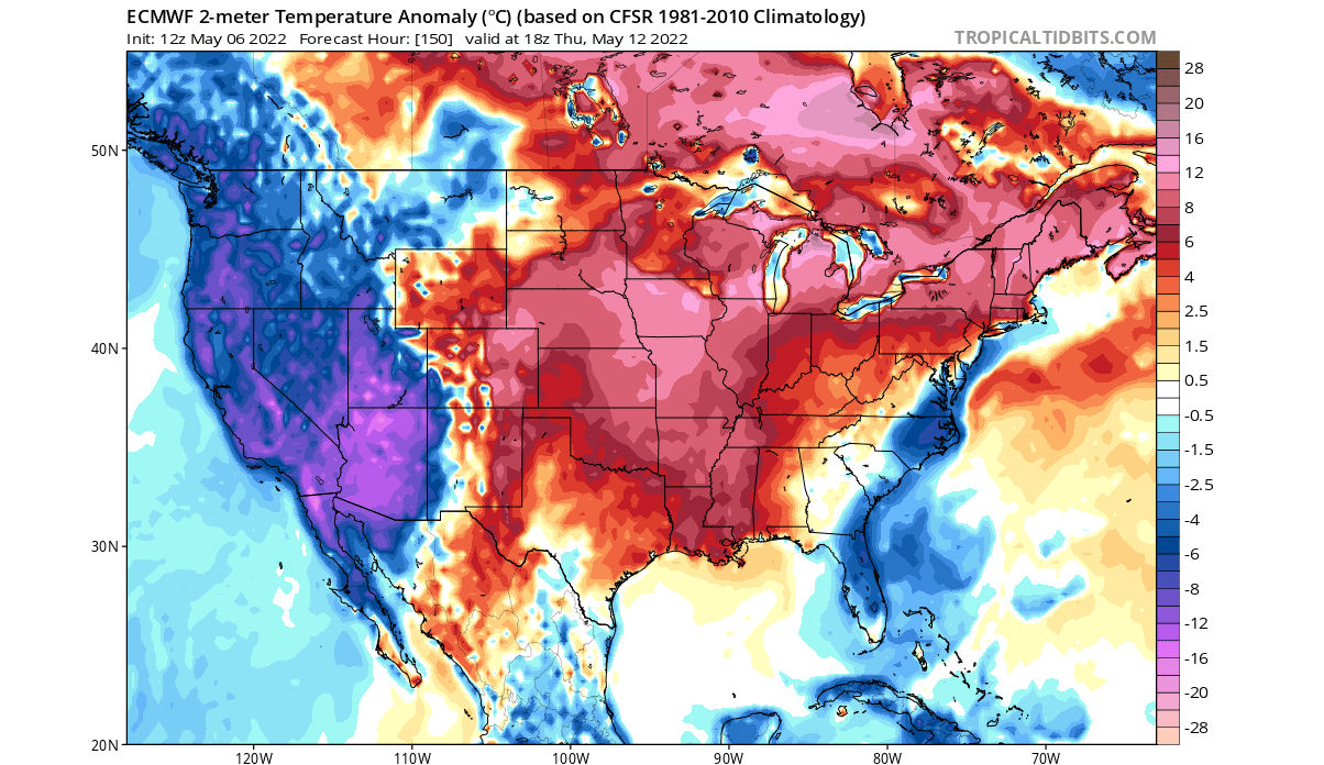
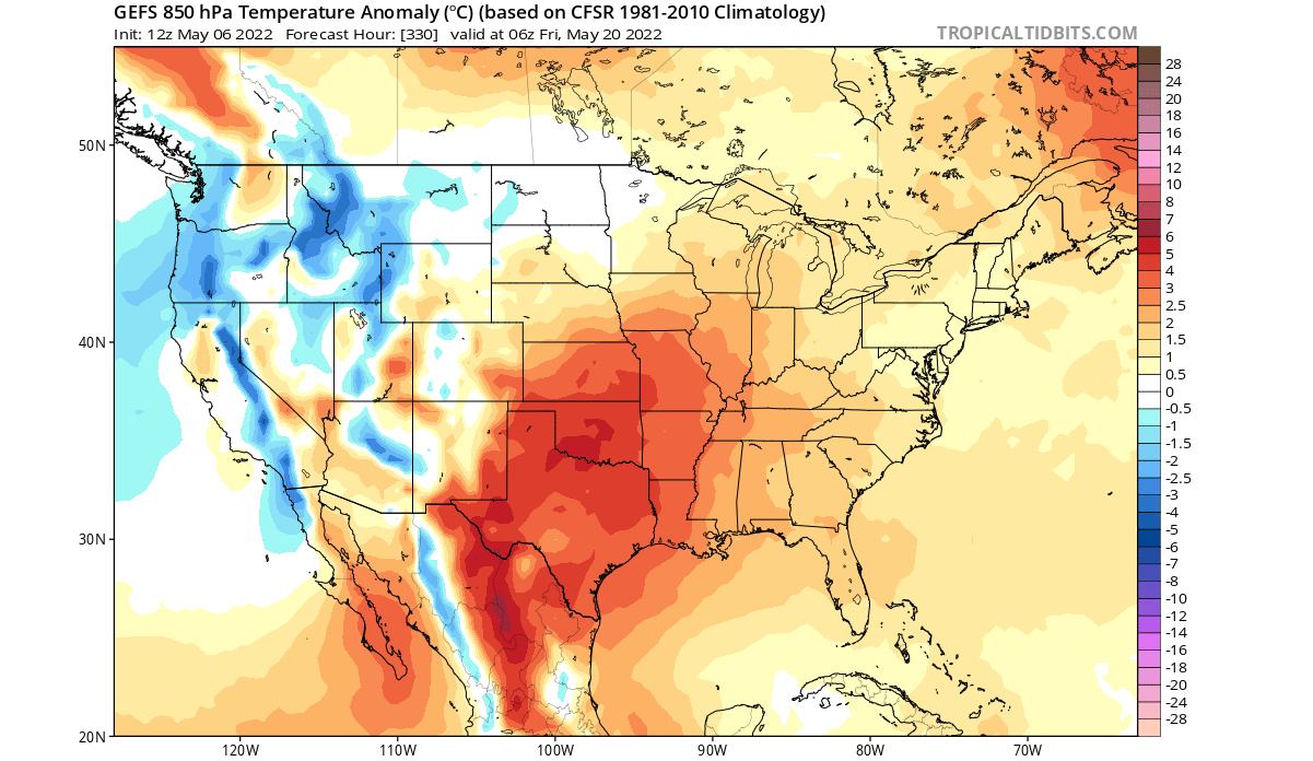
The image above shows the temperature anomaly forecast, which is a deviation from the long-term average. We can see that temperatures will be quite higher than normal, up to 10°C (~17°F) in the Midwest.
The actual temperatures will reach near 100°F in the southern United States, with temperatures in the high 70s and low 80s reaching up to the Canadian border. Of course, day-to-day temperatures will vary, but we will cover that in more detail in one of our upcoming articles.

MID-MONTH WEATHER PATTERN
Going towards the mid-month, we see further pattern progression. Low pressure in the Arctic keeps the AO index up, with the European ridge getting stronger. The low-pressure area over the western United States becomes semi-permanent for now, stabilizing the ridge over the east.

The temperature forecast for this period shows the cooler airmass staying over the far western United States. Unseasonably warm weather remains over much of the central and eastern United States, expanding into Canada. Warmer weather will also stay over western and central Europe.
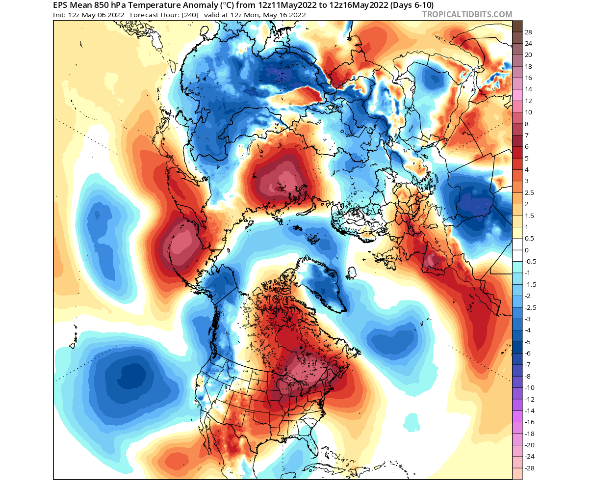
Looking closely at this period over the United States, we can see colder than normal air over most of the western United States. But even stronger and more widespread warm anomalies will take over much of the central and eastern United States.
Canada can also expect to see unseasonably warm temperatures, especially over the eastern part of the country. Cooler air is also forecast to remain over the east coast of the United States.
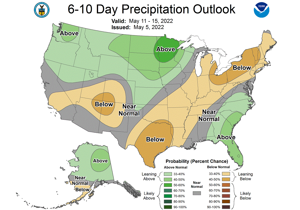
NOAA OFFICIAL 6-10 DAY WEATHER OUTLOOK
This is all nicely captured below on the official NOAA/CPC 6-10 day weather forecast. Colder than normal temperatures will prevail mostly over the western United States, as the low-pressure system descends down. But unusually high temperatures for this time will prevail over much of the central and eastern United States.

Stronger anomalies are expected especially in the Midwest, bringing unseasonably warm weather to this part of the United States. Warm anomalies will expand further to the north into Canada. The southern east coast and parts of Florida are expected to have normal to cooler than normal temperatures.
Looking at the official NOAA precipitation forecast, we have a trend for more precipitation over north/northwest, with a dry zone under the ridge over the southern and northeastern United States. More precipitation is also expected in the southeastern United States.
WEATHER IN THE SECOND HALF
Looking into the second half of the month, the low-pressure area remains around the polar circle. But the pattern eases in the United States. The low-pressure system weakens in the western United States, with a more persistent ridge building up. Strong high-pressure areas remain over Europe and in the North Pacific.
Temperature anomalies below show a plume of unseasonably warm weather expanding over western Europe up towards the British Isles. Warm weather is set to stay over much of the south-central United States and over parts of the southeast. Warm anomalies will also remain over Canada.

Looking closer at the United States pattern, we have an example forecast below, showing a possible scenario. The idea is that the low-pressure system over the northwest will lose strength. A high-pressure system remains over the country, maintaining warmer weather over much of south-central and eastern United States.
At the same time, warmer temperatures will remain under the ridge in the western United States. To a lower extent than in the west, warmer temperatures are also expected for the far eastern United States.
We do have to repeat, that this is further out in the forecast period, so it serves as an example of a possible scenario. The ensemble forecast supports this solution, which is the basis for weather forecasting at this range.
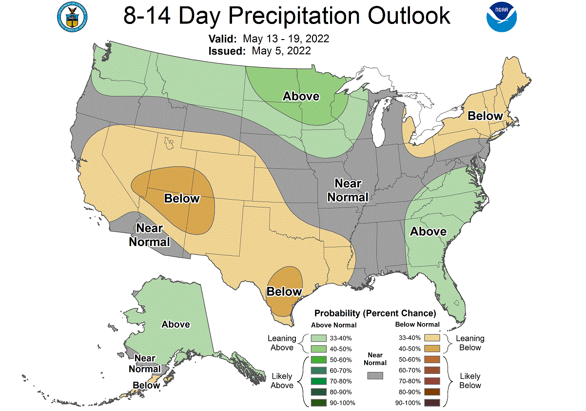
NOAA OFFICIAL 8-14 DAY WEATHER OUTLOOK
This is also captured below on the official NOAA/CPC 8-14 day weather forecast. Cooler temperatures will prevail mostly over the northwestern United States. Warmer weather is forecast to remain over central and eastern United States.
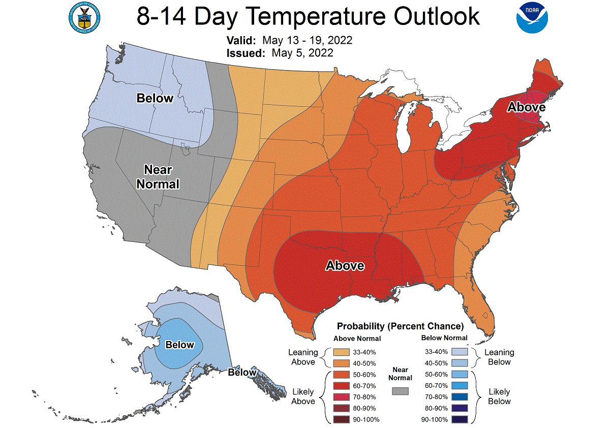
Looking at the official NOAA precipitation forecast, we have a trend for more precipitation over the northern and southeastern United States. Less precipitation is forecast for the northeastern and southwestern United States.
ENSEMBLE FORECAST
To put the whole period into perspective, we tend to use ensemble forecasts. This is a forecast made from various different calculations, each having different starting conditions. It helps us to consider different possible scenarios.
Below we have the ensemble temperature forecast for Kansas City, representing the south-central United States. We can see a strong warm push in the first half of the month. It eases going into the second half, but more ensembles trend toward continued warmer than normal weather.

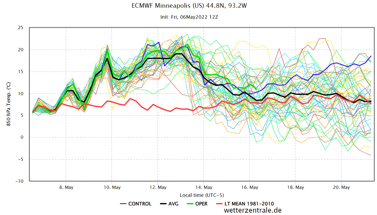
Representing the Midwestern United States, we have the ensemble forecast for Minneapolis below. It also shows unseasonably warm weather in the first half of the month, which we described above.
The ensemble forecast only goes out to 16 days. But the latest extended-range forecast from ECMWF was released this Thursday, so we can look at the latest late May forecast trends.
LATE MAY WEATHER PATTERNS
The pressure pattern forecast for late May shows sustained lower pressure over the polar regions. This will keep most of the coldest air close to the polar circle. High pressure is forecast over western and central Europe, and eastern Canada.

Looking at the temperature forecast for Europe in the same period, we can see mostly warmer than normal temperatures over the western and central regions. Given the anomaly extent at this range, we are likely to see near summer-like weather by the end of the month.

The temperature forecast for North America shows the colder temperatures remaining mostly in far western Canada. Warm weather is forecast to continue in the last week of May by the ECMWF. Warm anomalies cover the same regions from the south-central United States over the Midwest and into Canada.

We will finish off with the official monthly weather outlook for the United States by NOAA. It is released every month on their NOAA Climate page.
NOAA MAY 2022 WEATHER OUTLOOK
Looking at the NOAA official May temperature outlook, they have divided the country into two weather regions. Colder anomalies to the north and warmer weather to the south. Given the current model forecasts, it is unlikely that the Midwest will end up colder than normal.

The official Summer precipitation forecast shows more precipitation over the northwestern United States, extending into the south-central regions. Drier conditions are expected over the south and the southwestern United States.

The problem with such precipitation forecast is the presence of drought conditions in the southern and western United States. Below we have the latest drought analysis from NOAA, which shows the drought conditions across the country.

Most of the western half of the United States is under some level of drought conditions. The driest conditions prevail in the southern and northwestern United States. The latest precipitation forecast shows the drought to continue or worsen in the southern and southwestern United States.
We will release regular weekly and monthly updates on weather development, so make sure to bookmark our page, and also, if you have seen this article in the Google App (Discover) feed, click the like button (♥) there to see more of our forecasts and latest articles on weather and nature in general.
SEE ALSO: