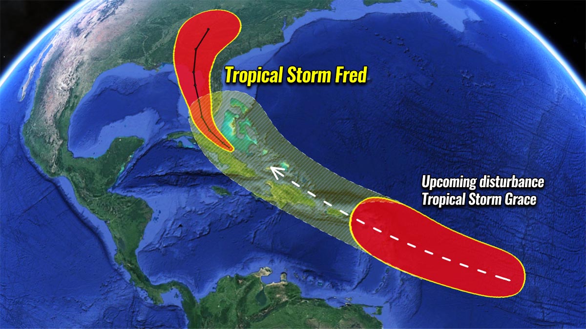
Warnings are in place for the Florida Keys as Tropical Storm Fred is re-emerging along northern Cuba. Fred heads for the 4th landfall of the tropical system in the U.S. mainland of this very active Atlantic hurricane season 2021. Meanwhile, a potentially more dangerous tropical wave will churn a Tropical Storm Grace over the weekend, taking a similar track as Fred, moving towards Florida next week.
Tropical Storm Fred has developed in the tropical western Atlantic just a few days after the official release of the recent NOAA seasonal outlook for the ongoing Hurricane Season. This was way ahead of schedule, as typically, the 6th named tropical cyclone forms on August 28th. The season this year remains nearly 3 weeks ahead of the schedule.
Note, that the emerging upper-level pattern is now strongly supportive of additional tropical development, lead by both the deep MJO wave aloft and much above normal warmth of the Atlantic Ocean and the Caribbean Sea waters. Hence, we are expecting another storm Grace very soon.
Besides the current tropical activity ramping up, the recent forecast update by NOAA calls for an even higher potential for an above-normal Atlantic hurricane season this year. Now a 65 % probability is forecast for a very active storms throughout the upcoming peak of the hurricane season, supported by both the returning La-Nina and very warm Atlantic waters.
Ahead of Fred, tropical storm warnings were issued for the Florida Keys as the system is gradually getting back to shape about 300 miles southeast of Florida. Residents of southern Florida should be prepared for their second impact of the tropical system this season.
Significant rains and flooding is the main concern for the Florida Peninsula. The southwest coast of Florida from Englewood south and east to Ocean Reef and under tropical storm watch.
ATLANTIC HURRICANE SEASON SO FAR
Tropical Storm Fred is the 6th tropical cyclone of the Atlantic Hurricane Season 2021 and will be the 4th landfalling system along the United States mainland coast. The above-normal activity will soon continue as another, 7th tropical storm is expected to form in the tropical Atlantic over the weekend.
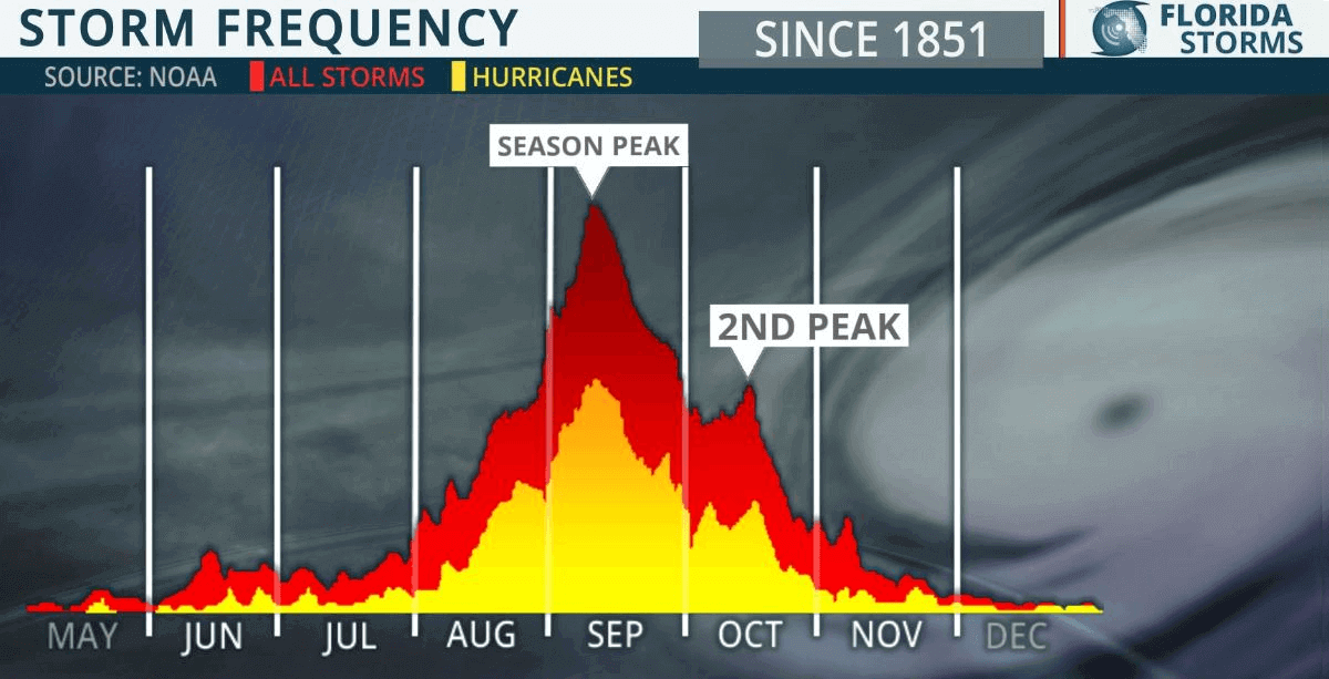
Throughout an average year, the Atlantic hurricane season produces around 14 named tropical storms. About 7 of those normally become hurricanes with 3 of them also reaching the major hurricane strength (a Category 3 or greater).
And there are normally two peaks when activity ramps up. Through the second half of August and early September, the hurricane season takes a higher gear with a steep increase in the tropical waves moving across the Atlantic, affecting both the Caribbean region and the United States. Followed by a secondary boost in the activity happening through mid-October.
Although the tropical activity around the world is one of the more complex meteorological fields, its specific conditions combined together often lead to the development of dangerous tropical weather threats for the land and property. The most dangerous parts are indeed landfalls of hurricanes to vulnerable coastal areas every year.
In particular, the Atlantic hurricane season this year has become concerning as the odds are increasing that La Nina will re-emerge again this fall, and continue to support weather patterns leading to much above-normal activity and higher potential for US landfall remains, according to NOAA forecast.

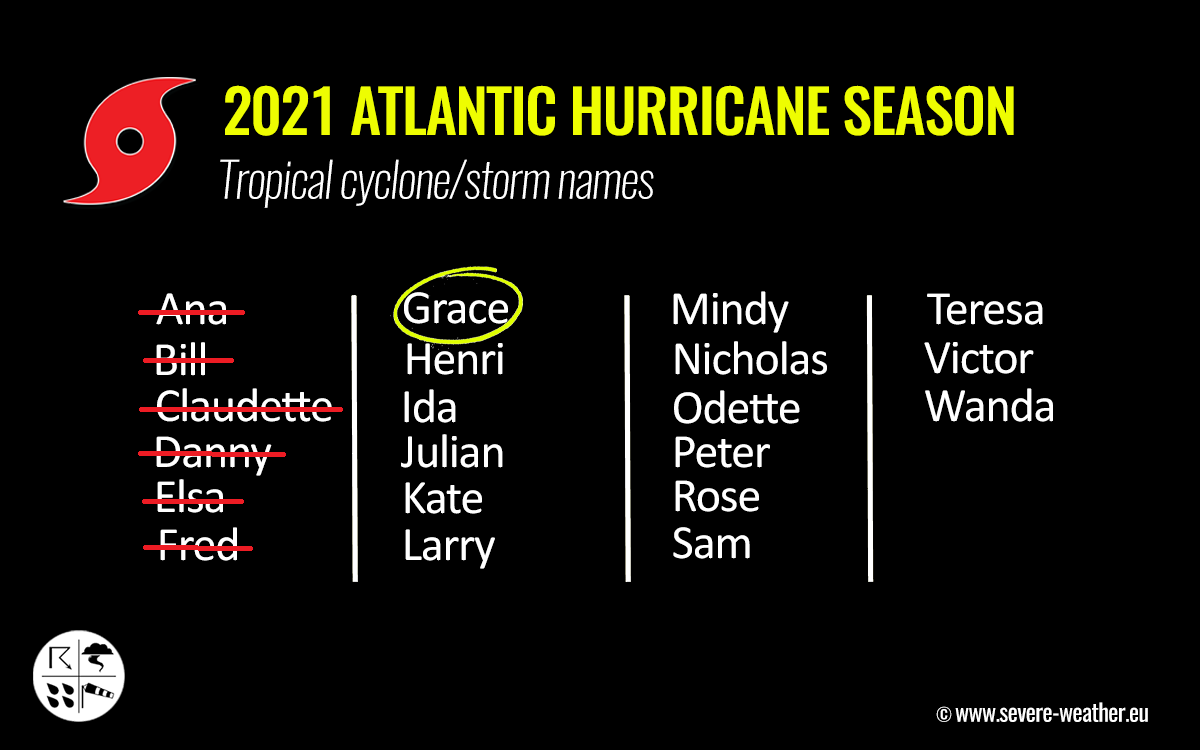
The Atlantic Hurricane Season 2021 has started more than 10 days before the official start on June 1st, Tropical Storm Ana formed in the Atlantic. And the activity continues with an impressive and record-breaking pace despite a few week’s break recently.
Six named storms have already formed, including the ongoing Tropical Storm Fred. And three of those made landfall in the US territory, Danny, Claudette, and Elsa. Fred will be the 4th cyclone to do so in Florida Keys this weekend. Grace will form this weekend.
Soon after nearly a month-long period of basically no tropical activity in the Atlantic Ocean, the activity is now ramping up. Right now, the very warm sea waters are coinciding with a major MJO wave* aloft, emerging into the Caribbean region and the tropical Atlantic from the Pacific Ocean. Both are now triggering more tropical storms and boosting the activity.
*MJO wave is an eastward-moving wave that normally has a major influence on the state of the atmosphere which allows tropical storms or hurricanes to develop. While tropical systems require high moisture and a very warm sea temperature (26 °C or above), a low vertical wind shear, and strong support aloft are needed. See further down for more details on why the MJO is such an important factor in the tropical region.
VERY WARM TROPICAL ATLANTIC WATERS COMBINE WITH DEEP MJO WAVE
The Atlantic Basin water surface temperatures (SST) warm up a lot throughout the summer months and are typically leading to temperatures even above 30 °C in places. With the recent sea surface temperature anomaly analysis, we have found that the whole Atlantic Basin has anomalously warm waters. Including the Caribbean, the Gulf of Mexico, and most of the tropical and North Atlantic.
The warmest waters are spread across the western Caribbean region and the Gulf of Mexico. Temperatures are ranging from around 27-29 °C in the tropical Atlantic to around 30 °C in the northwestern Caribbean around Cuba. Even warmer waters with 30 to almost 32 °C (90 °F) are analyzed across most of the Gulf of Mexico. This is extremely warm for mid-August.
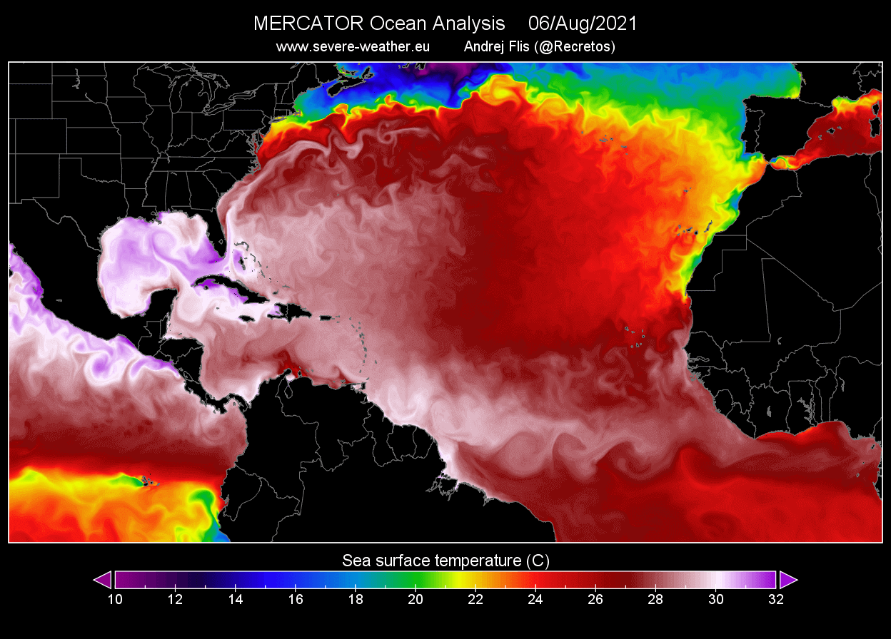
Such water temperatures could lead to explosive and very dangerous tropical cyclones later during the peak of the Atlantic hurricane season this fall. Warm waters are a very significant signal for the upcoming tropical cyclones that may move across this part of the tropical region as convective storms will fuel from these conditions.
The SSTs are anomalously warm especially across the MDR region (Main Development Region). A part of the tropical Atlantic that virtually extends between Africa and the Caribbean Sea. The majority of the tropical cyclone formations normally occur in the MDR region.
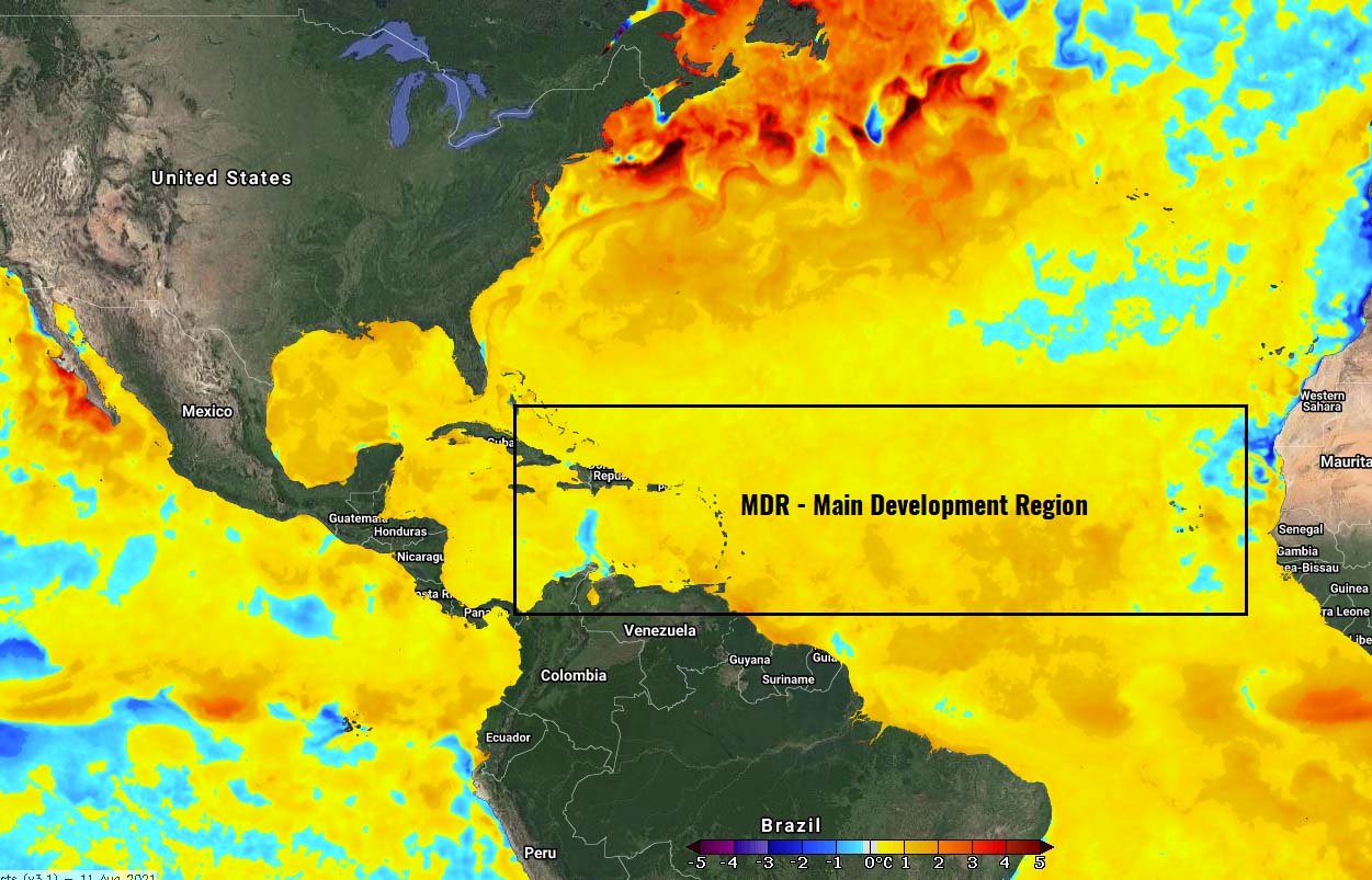
With the high-resolution animation below, we can see the Atlantic Basin oceanic waters temperature anomalies are strongly above normal, including across the MDR region mentioned above. Such significant temperature anomalies do hint at the strong support for potentially very significant tropical cyclone development in the coming weeks.
According to the weather model trends, these high sea temperatures will remain or even improve in the coming weeks as we head towards the peak of the Atlantic Hurricane Season. Such SSTs in August are also quite a typical sign when an active season follows.
At the same time, a deep MJO wave has emerged into the Caribbean region and the Atlantic Ocean from the west. A Tropical Storm Fred has gained direct support by these improving upper-level conditions, and those will also help to boost further development with the upcoming Tropical Storm Grace in the coming days.
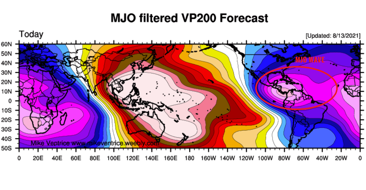
The chart above, provided by Michael J. Ventrice, indicates the current MJO wave with filtered VP200 anomalies. A Velocity Potential is an indicator of the large-scale divergent flow in the upper levels of the atmosphere over the tropical region. The blue colors support the tropical cyclone development, the red colors are the opposite.
As we learned, the MJO wave is known as the Madden-Julian Oscillation, a very important factor for cyclone formation in the tropical region. The largest and most dominant source of short-term tropical variability circles the Earth in about 30 to 60 days.
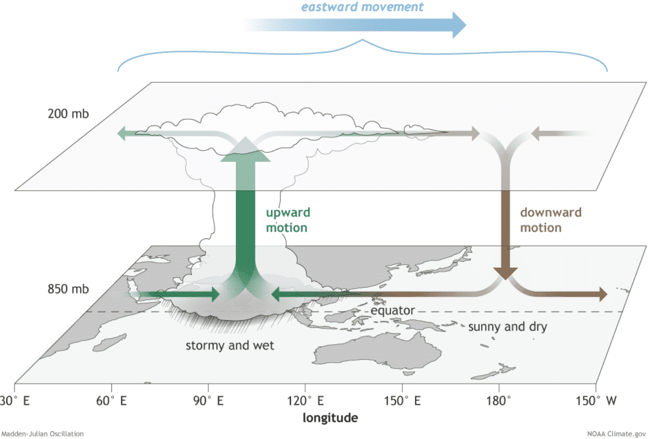
When a region is overspread by a deep MJO wave, this normally develops a low wind shear environment and leads to more favorable conditions for tropical cyclone development.
TROPICAL STORM FRED NOW HEADS TOWARDS LANDFALL IN FLORIDA KEYS THIS WEEKEND
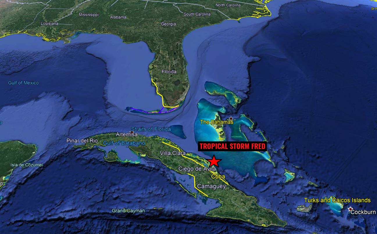
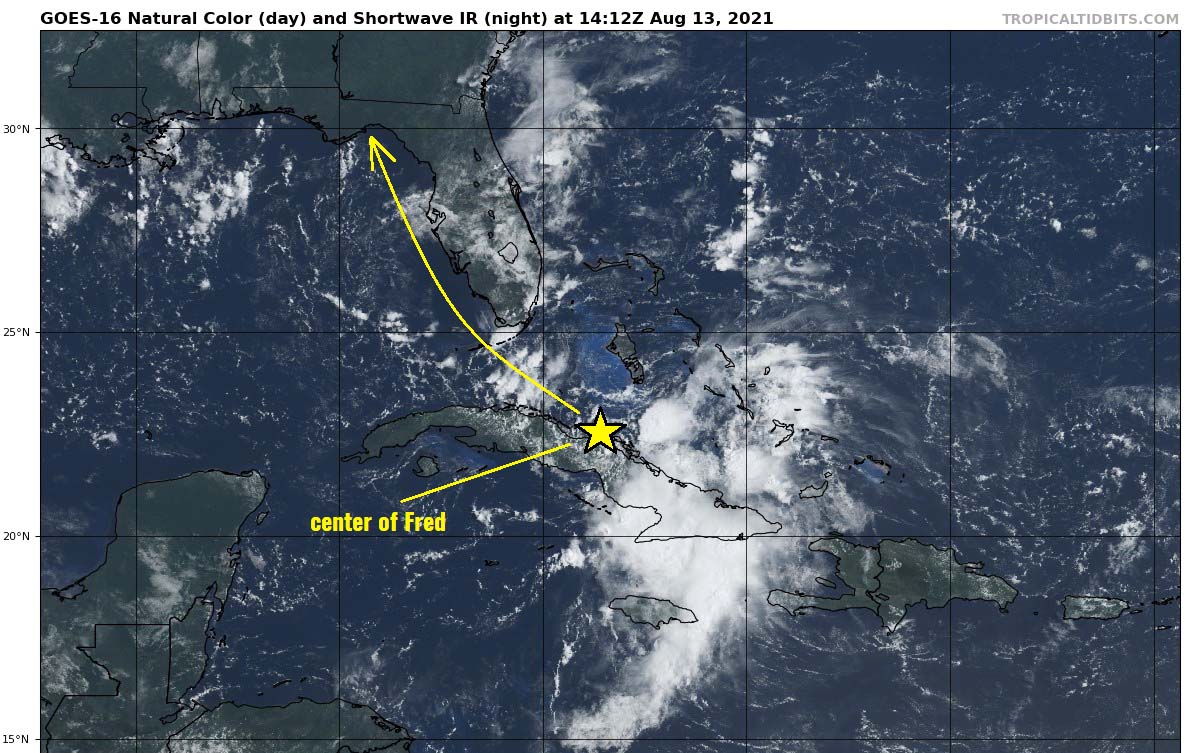
The recent satellite and hurricane hunters observations have found that Fred will re-emerge its Tropical Storm strength and continue northwestward, towards the 4th seasonal U.S. mainland landfall. This will bring Fred right across the Florida Keys on Saturday afternoon.
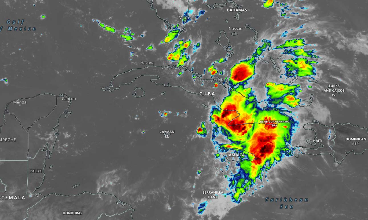
Fred was producing heavy rains across eastern Cuba and portions of the southeastern Bahamas on Friday, gradually re-emerging while moving back to the warm sea waters between Cuba and Florida. Despite some shear aloft, Fred will strengthen before it reaches the Florida Keys.
Very heavy rainfall with an increasing potential for an areal, urban, small stream, and exacerbated river flooding will develop across southern and central Florida into the Big Bend from today into Monday. And from Sunday onward the heavy rain and flood impacts should also extend into other portions of the Southeast United States.
Tropical Storm Fred is forecast to head for its secondary landfall in Florida Peninsula on Monday and should expand the rainfall and flooding threat also into the southern and central Appalachians and Piedmont.
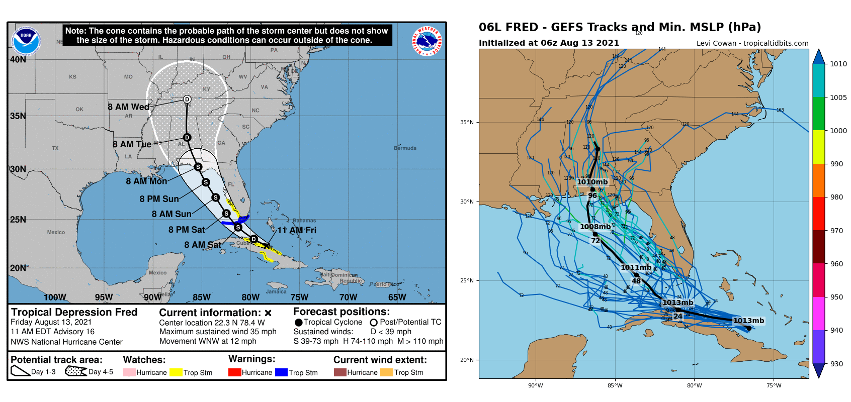
Tropical storm conditions are expected in the Florida Keys on Saturday when the center of Tropical Storm Fred will move across. For this reason, a Tropical Storm Warning has been issued.
Tropical storm conditions are possible from late Saturday through early Sunday across portions of the west coast of Florida. Then, the risk of tropical storm conditions will spread northward along the Florida west coast and to the Florida Panhandle from Sunday into Monday.

The highest amount of rainfall will strongly depend on Fred’s track as it continues along the western Florida peninsula over the weekend. The highest amounts could be just west of Florida but residents along the western coasts should be alert.
Up to near 250 mm (10 inches) seems likely near the center of the storm, with an excessive rainfall swath from the Florida Keys to the Florida Panhandle.
THE UPCOMING 7TH STORM (GRACE) OF THE ATLANTIC HURRICANE SEASON COULD ALSO TURN TOWARDS FLORIDA
Fred should soon get a company with another potential even more dangerous tropical cyclone, emerging over the tropical weather Atlantic in the recent days. This will be the Tropical Storm Grace, the 7th system of the Atlantic hurricane season 2021.
A potent tropical wave is located about 850 miles east of the Lesser Antilles this Friday, moving west-northwest. The ongoing activity of showers and thunderstorms has become a little better organized as the wave is moving deeper into the MJO wave aloft farther west.

One can also see a hurricane Linda ongoing in the Eastern Pacific, making a line of three active tropical waves active today. The other two, Fred and upcoming Grace are marked in the Atlantic Basin.
The strongly supportive MJO wave hints that the environmental conditions are becoming more conducive for additional development as the new wave tracks further west. A tropical depression is likely to form over the next day, then the system is expected to reach portions of the Leeward Islands Saturday night and the Virgin Islands and Puerto Rico by Sunday.
Tropical storm conditions will soon be develop across portions of the Leeward Islands, the Virgin Islands, and Puerto Rico once Grace strengthens further and arrives closer to the Caribbean region. Strong winds and heavy rainfall are likely to spread across these areas over the weekend.
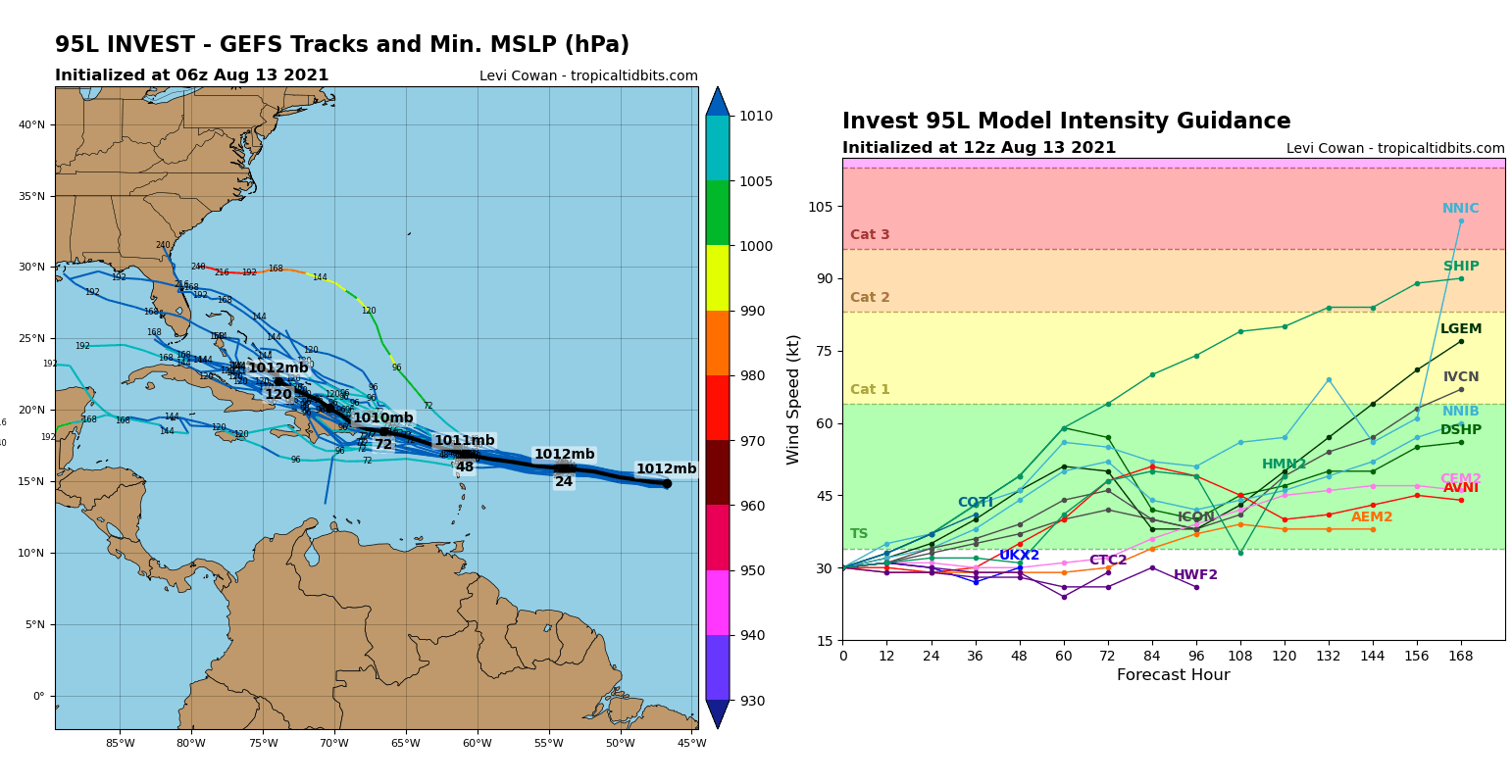
The National Hurricane Center (NHC) given the system a high, 80 percent chance to become a Tropical Storm Grace over the next few days.
NOAA FORECAST CALL FOR AN ACTIVE ATLANTIC HURRICANE SEASON THIS FALL
August is the month of the Atlantic Hurricane Season 2021, out of 6 months in total when tropical cyclones typically occur every year. We are now entering a period when the activity is the highest. And the recent NOAA outlook update is not something we would want to see: An above-normal and very active hurricane season are expected as we head towards the peak of the hurricane season.
The NOAA forecast update hints at a 65 % chance of above-average activity remains in the forecast this year, 5 percent more than they initially expected. The forecast also calls for 15-21 tropical cyclones, compared to the 13-20 storms from the initial forecast.
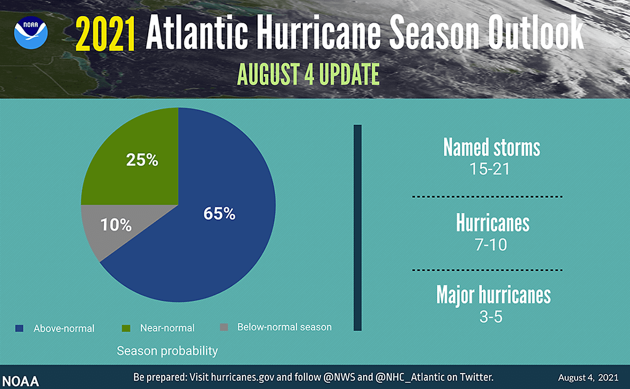
The forecast also hints at the potential that about 7-10 hurricanes could develop with season, where 5 of those could become major (Category 3 or greater) hurricanes. And similar thinking is also by the CSU forecasters, lead by dr. Phil Klotzbach.
The CSU team is predicting 18 named storms (those include the first six storms) with the Atlantic hurricane season 2021. Expecting all the monitoring parameters likely being above average again this year. Around 80 named storm days, 8 hurricanes, and 4 major hurricanes can be expected this year.

These forecasts by both NOAA and CSU are based on the recent changes in the Pacific Ocean waters as La Nina will likely re-emerge this fall. And at the same time, there is an enhanced west African monsoon underway this summer. This leads to strong tropical waves of thunderstorms that are being pushed west into the eastern Atlantic Ocean.
***The images used in this article were provided by NOAA, and Windy.