Less than a month after the first major hurricane (Felicia) of the Eastern Pacific Season 2021, another violent Category 4 storm is grazing west of central America. Hurricane Linda is the 2nd major storm of the season, packing 130 mph with an outstanding satellite presentation.
The tropical cyclone activity across the East Pacific has significantly ramped up recently, thanks to very favorable environmental conditions as a major MJO wave has been traveling east over the region. Hurricane Linda is the 12th named storm of the Eastern Pacific Hurricane Season 2021 and the 4th hurricane so far.
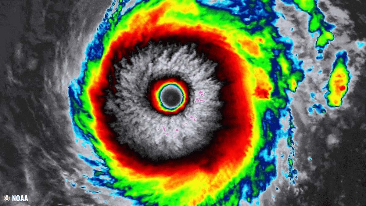
A major Category 4 hurricane Linda has 130 mph (115 knots) of sustained winds with a minimum central pressure of around 950 mbar. The satellite imagery indicates a textbook, near-ideal circular shape with a huge eye. An almost symmetrical ring of very cold cloud tops followed soon after an EWRC – Eyewall Replacement Cycle on Friday night which pushed Linda to a major hurricane strength.

Similar to the first major hurricane of the Eastern Pacific season, Linda’s development was pretty fast. Within a period of just a few days, Linda has strengthened from a tropical storm to a major hurricane.
The satellite animation below is showing a pretty spectacular satellite presentation of hurricane Linda, having an almost perfect symmetry of the structure. Linda is a large and very intense hurricane with a huge eye. The animation includes Infrared, Water Vapor, and Visible satellite spectrum imagery.
This Saturday, a major hurricane Linda remains a very powerful and impressive Category 4 storm, tracking west across the Eastern Pacific and its trajectory could potentially bring it towards Hawaii about the next weekend. The system is currently moving westward with near 10-12 knots.
EAST PACIFIC HURRICANE SEASON 2021
The East Pacific Hurricane season 2021 officially begins a half month earlier than the Central Pacific of the Atlantic hurricane seasons. The official date is set to May 15th, while the other two basins start on June 1st. Both tropical regions of the Pacific season will end on November 30th.
As of mid-August, the Eastern Pacific hurricane season 2021 has already generated 12 tropical depressions with all the systems also getting their tropical cyclone names. The strongest storm was hurricane Felicia which formed a month ago and still remains the strongest hurricane of the year.
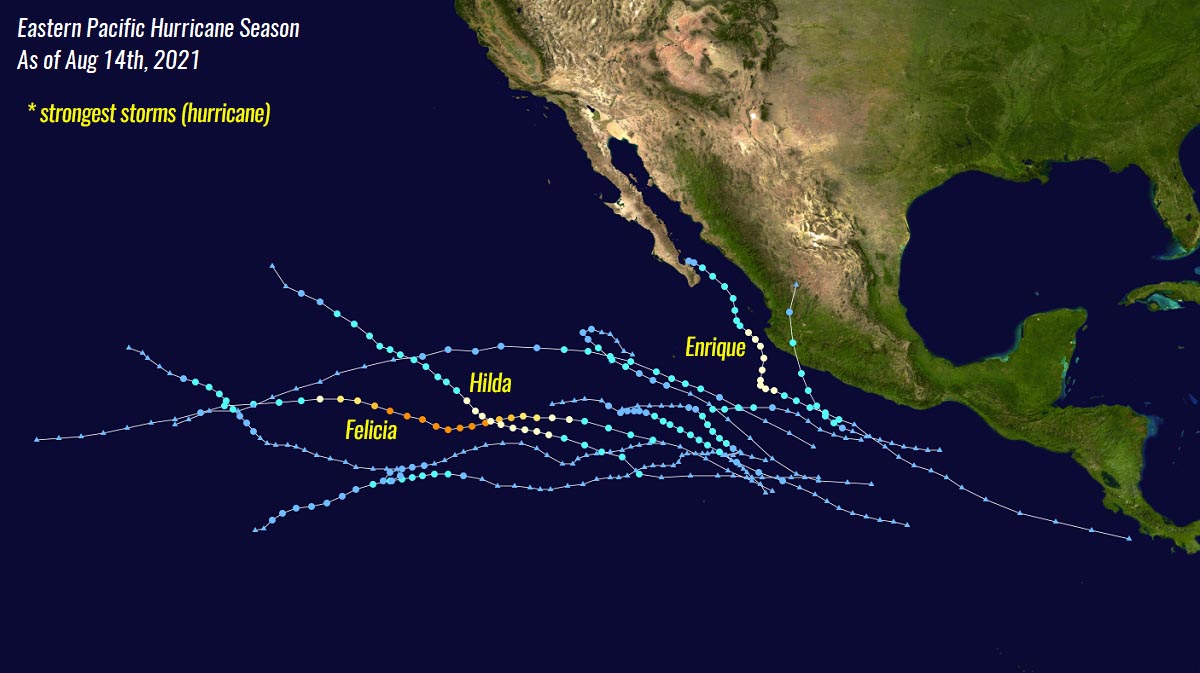
There were two hurricanes more so far this season, one was hurricane Enrique and the other was hurricane Hilda earlier this August. The other 8 were tropical storms: Andres, Blanca, Carlos, Dolores, Guillermo, Jimena, Ignacio, and Kevin. Making a total of 12 systems so far which is hinting at an extremely active hurricane season in the East Pacific basin.
Note that on average, there are 15 named tropical systems during a typical Eastern Pacific hurricane season. 8 of those become hurricanes while 4 of those become Category 3 or greater, so a major hurricane.

The seasonal outlook prediction issued by NOAA forecasters predicts about 14-20 named tropical cyclones for the East Pacific basin, with 7-10 hurricanes and also 4-5 major hurricanes that could develop during the hurricane season 2021. As we can see, we are almost catching the prediction despite there are still 3 months left until the end of the season.
This year, the WMO (World Meteorological Organization) committee has designated 22 tropical cyclone names for the Eastern Pacific hurricane season. These have started with Andres and will end with Zelda.

Similar to the Atlantic Hurricane Season, also the first tropical storm Andres formed about a week before the official start , it was active from May 9th to 11th, 2021. The second tropical storm was Blanca, which formed on May 30th and dissipated on June 4th.
Blanca was soon followed by Tropical storm Carlos between June 12-16th, and Dolores between June 18th to 20th. Before the 5th storm formed – hurricane Enrique (June 25th to 30th), Dolores held the torch as the strongest tropical cyclone of the Eastern Pacific hurricane season 2021.
Then, the first major hurricane of the Eastern Pacific season develop – A category 4 hurricane Felicia (above), It peaked at 145 mph and reached the minimum central pressure of 947 mbar. Since Felicia, 4 more storms formed with a Category 1 hurricane Hilda being the strongest at the beginning of August.
The East Pacific season this year has started incredibly fast and active, thanks to significantly warmer sea waters than normal and also as the major influence was brought by the favorable upper-level support. MJO waves twice helped to ramp up the activity, including the last two weeks.
VERY WARM PACIFIC SEA AND DEEP MJO WAVE BOOSTED THE EAST PACIFIC HURRICANE SEASON
The East Pacific Ocean sea waters remain extremely warm, even hot in some places closer to the central American coast. Temperatures are a few degrees above the long-term average for the region. Surface waters have sea temperatures ranging between 30 and 31 °C near the western Mexico coast.
Researchers have found that when the East Pacific Basin has above-normal sea surface temperatures (SSTs), this brings a pretty good correlation with what’s the typical July and August SSTs pattern. Thus, an above-normal hurricane season is likely to follow in such a year.
These conditions work very similar to the Atlantic hurricane season which is also significantly ramping up lately and should continue as a very active through the next few months.

Very warm sea (oceanic) temperatures are just one of the ingredients that tropical cyclones need to develop, the other important ingredient is the environment. The low wind shear and strong upward motion – are typically provided by what is known as the MJO wave.
We know the MJO wave as the Madden-Julian Oscillation. This is the largest and most dominant source of short-term tropical variability around the world. MJO is an eastward-moving wave of thunderstorms that circles the entire planet on the equator in about 30 to 60 days.

MJO wave has two parts – a wet phase, and a dry phase which tells us that there is increased convective activity with a lot of rainfall on one side and reduced thunderstorm potential, and more stable weather on the other side. The horizontal movement of the air masses within the MJO wave is known as the Velocity Potential (VP) in the tropical region.
The graphics below, provided by Michael J. Ventrice, Ph.D. is showing an MJO wave with filtered VP200 anomalies for mid-August period. The VP200 is an indicator of the large-scale divergent flow in the upper levels over the tropics. When we have negative VP anomalies (blue colors), there is a divergent outflow from enhanced convective regions.

We can see the deep MJO wave that is currently ejecting the East Pacific region, emerging into the Atlantic Basin. This wave was the reason for the strong tropical cyclone activity in the Pacific side recently, while the Atlantic is now the next to the significant activity as we head towards the peak weeks of both hurricane seasons.
LINDA IS THE 2nd MAJOR HURRICANE IN THE EAST PACIFIC THIS YEAR
Linda has formed on August 6th as a tropical disturbance several hundred miles west of Mexico. Thanks to the very warm sea waters and upper-level support by the MJO wave, it quickly gained strength and organized into a depression. Lind became a hurricane on August 12th (Thursday) and was rapidly intensifying since then.

The maximum sustained winds have quickly risen to major hurricane strength on Friday this week, reaching around 115 knots (130 mph) on Friday night. Hurricane Linda, now acting as a major hurricane is near its peak while it continues tracking further west-northwest across the East Pacific.
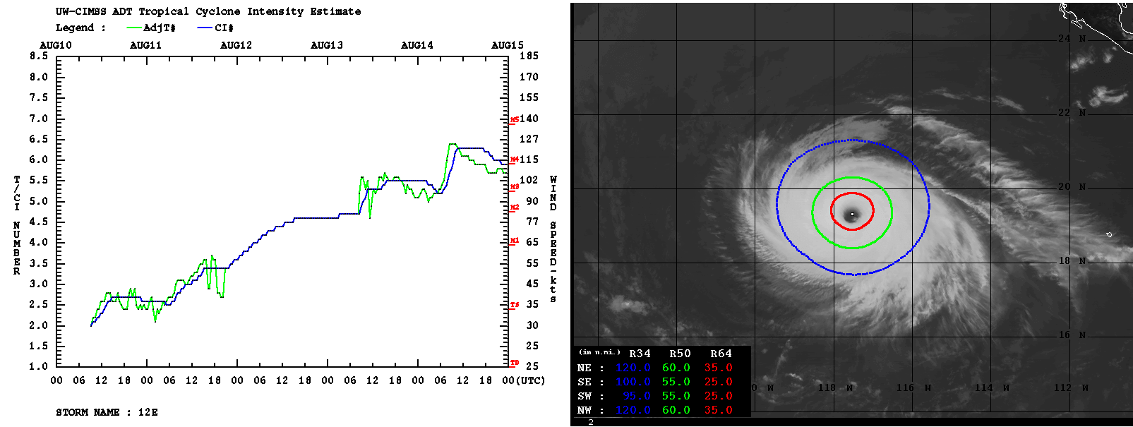
Based on the recent satellite imagery this Saturday, Linda has developed an impressive large eye, surrounded by a compact and very intense eyewall. Revealing a spectacular stadium effect.

Once the Eyewall Replacement Cycle (EWRC) was finished last night, Linda’s intensification has more or less stopped, but it remains a very powerful Category 4 storm.
The recent Advanced Dvorak Technique (ADT) analysis keeps Linda at around 110 knots of sustained winds with the central pressure of near 955 mbar. The final T number is stable at around 5.7. Major hurricane Linda has 50-knots wind radii of about 50-60 miles across, while the 64-knots with hurricane-force winds are about 25-30 miles across.
Over the next few days, hurricane Linda will continue moving west-northwest towards the central Pacific. The exact track is more or less well forecasted up to five days in advance, but then the ECMWF model hints at a closer trajectory to Hawaii, while GFS pushed Linda farther north of the archipelago.
Attached below is the comparison forecast track by the ECMWF and GFS models.

Note, that over the next 48-72 hours, Linda will move farther west into less favorable oceanic conditions which should result in a gradual but slow weakening of the hurricane through early next week. Soon as the system moves over the sea waters with a temperature of below 26 °C.
These temperatures should limit the intensification process despite the low vertical wind shear conditions persist along its forecast track. Normally, sea temperatures of more than 26 °C are required for tropical storms/hurricanes to sustain their intensity.

Attached below is the wind swath of Hurricane Linda as it tracks westward towards the Central Pacific in the next 7-10 days. An intense wind swath can be noticed for a few more days, as Linda is expected to remain an intense hurricane.
This is the ECMWF model solution. The potential that Linda could reach the Hawaii archipelago is minimal for now, but the system should be tracked further in the coming days.

***The images used in this article were provided by NOAA, Tropical Tidbits, and Windy.