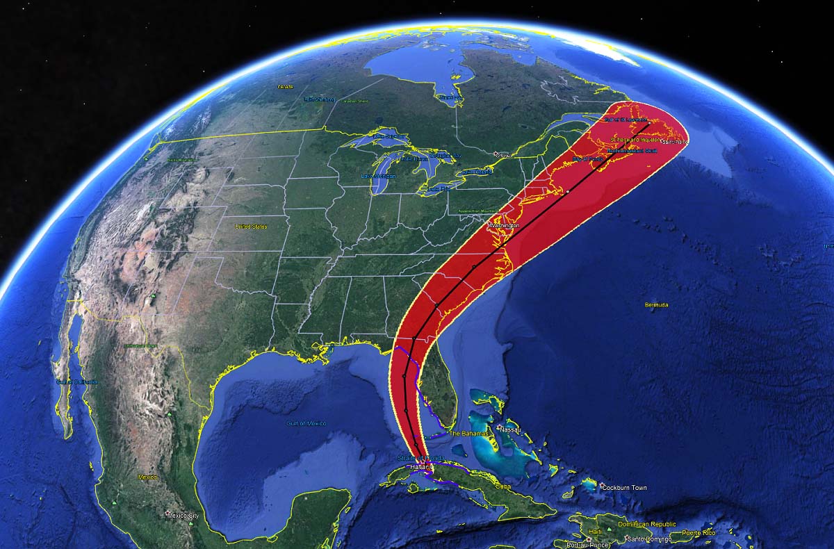
Tropical Storm Elsa has made landfall in Cuba this Monday, with the center of the low coming ashore in Ciénaga de Zapata National Park, about 80 miles southeast of Cuban capital Havana. The maximum sustained winds at the time of landfall were 60 mph. Now, Elsa is heading towards Florida where a dangerous landfall is expected on Wednesday. Once Elsa goes ashore in Florida, this will be the 3rd landfall of the Atlantic Hurricane Season 2021 on the United States mainland.
Elsa’s landfall in Cuba was the first July storm after Hurricane Dennis back in hurricane season 2005. Once Elsa is off Cuba, its center will re-emerge over the southeastern portions of the Gulf of Mexico and take a more northerly track afterwards. Right towards its second landfall in Florida on Wednesday.

A Tropical Storm Warning is in effect for:
- The Cuban provinces of Cienfuegos, Matanzas, Villa Clara, Mayabeque, Havana, and Artemisa
- The Florida Keys from Craig Key westward to the Dry Tortugas
- West coast of Florida from Flamingo northward to Ochlockonee River
A Storm Surge Warning is in effect for:
- West coast of Florida from Bonita Beach to the Aucilla River including Tampa Bay
A Tropical Storm Watch is in effect for:
- West of the Ochlockonee River to Indian Pass, Florida
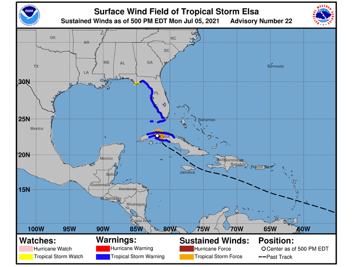
Remember: A Storm Surge Warning means there is a danger of life-threatening inundation, from rising water moving inland from the coastline, during the next 36 hours in the indicated locations. A Tropical Storm Warning means that tropical storm conditions are expected somewhere within the warning area.
The seawaters of the Gulf of Mexico waters are already pretty warm, so Elsa will gain additional strength. But at the same time, some low wind shear will probably limit a more significant intensification prior to landfall in Florida.
Tropical Storm Elsa will make effect to Florida on both Tuesday into Wednesday, as rain bands are wide open well ahead of the storm’s center moving over Cuba Monday night. Elsa will bring heavy rain, flooding threat, storm surge, and also tornado threats as it nears the peninsula, starting Tuesday and worsen on Wednesday.
ATLANTIC HURRICANE SEASON 2021 MEANS SERIOUS BUSINESS
The tropical Atlantic Basin sea waters are already very warm, especially across the western Atlantic, including the Caribbean region and a large part of the Gulf of Mexico. Sea surface temperatures are from around 27 °C in the central Atlantic, up to around 30 °C in the western Caribbean. Similar water temperatures of 27-29 °C are spread across the Gulf of Mexico, with the highest sea temperatures observed across the western portions of the Gulf.
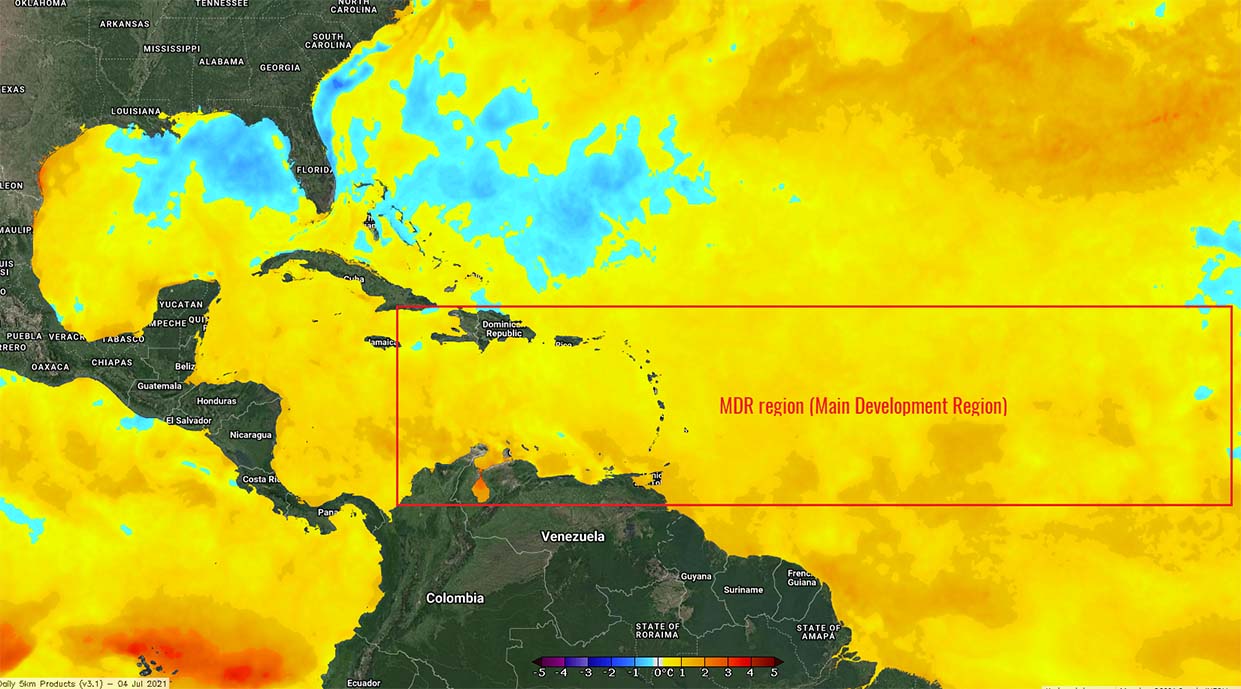
Strongly supportive ocean waters with above-normal sea surface temperatures are also in the so-called MDR region (Main Development Region) between Africa and the Caribbean Sea). Warm seas in this area usually mean that the potential for tropical cyclone formations will easily fuel from the very warm tropical Atlantic ocean waters in the coming weeks and months.
The Atlantic hurricane season 2021 began setting early records, similar to the last year. Tropical Storm Elsa was the first hurricane of the season and also the farthest east that a hurricane has formed this early in the calendar year in the tropical Atlantic (that means south of latitude 23.5° N) since 1933.
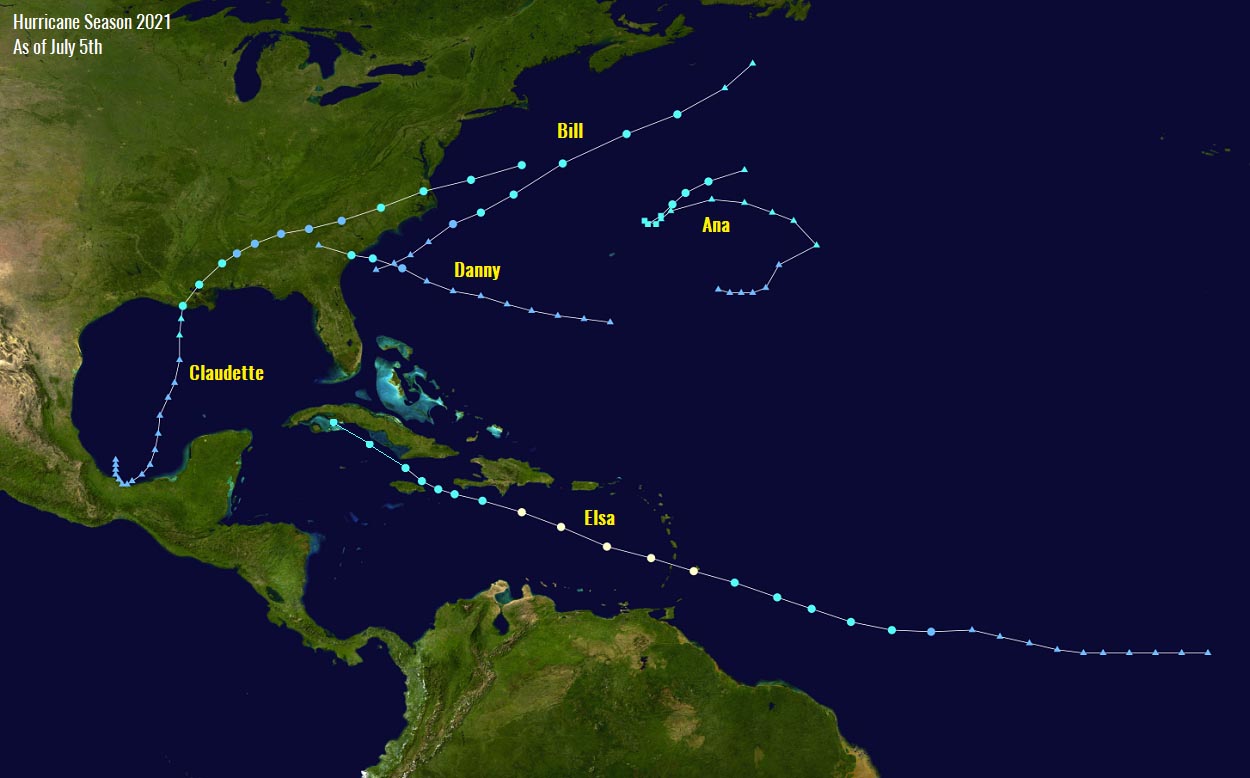
Tropical Storm Ana
Tropical Storm Ana was the very first tropical cyclone of the Atlantic hurricane season 2021. Ana formed on May 22nd, so about 10 days before the official start. The peak intensity of Ana was 45 mph, it also generated an ACE of 1.01. The minimum central pressure of the storm was 1006 mbar.
Tropical Storm Bill
The second named tropical cyclone was a Tropical Storm Bill. It has formed several hundred miles east off the coast of North Carolina and was active for two days, from June 14 to 16th. Bill never had any land areas interactions as it remained over the open waters of the Northwest Atlantic with the peak winds intensity of 60 mph and the minimum central pressure of 998 mbar.
Tropical Storm Claudette
The 3rd named storm was Tropical storm Claudette that has formed along the Mexico coast in the southwestern Gulf of Mexico on June 19th. Claudette crossed the Gulf and made the very first landfall of any tropical cyclone of the Atlantic Hurricane season 2021 along the U.S. mainland about 36 hours later.

Claudette had a peak intensity of 45 mph with a minimum central pressure of 1004 mbar while crossing the Gulf of Mexico prior to making landfall in southern Louisiana. After the landfall, Claudette was soon downgraded into a tropical depression while moving across the Southeast U.S. and ejecting into the Atlantic a few days later.
Tropical Storm Danny
Monday, June 28th, brought a Tropical Storm Danny, the 4th named tropical cyclone which has shown that it means seriously with the term “above-normal” Atlantic hurricane season 2021. Although Danny lasted for less than 24 hours, it brought heavy rain and gusty winds at the time of landfall on the southwest South Carolina coast on the same day.
Tropical Storm Danny was also the 2nd tropical cyclone that made landfall on the US mainland, after Claudette. And also the first June landfall in South Carolina in more than 150 years, after Hurricane One in 1867.
Note: An average Atlantic hurricane season typically produces up to 14 named tropical storms, 7 hurricanes, and also around 3 major hurricanes. The hurricane season has two peaks, where one occurs during the early/mid-September and the second one normally occurs in mid-October.
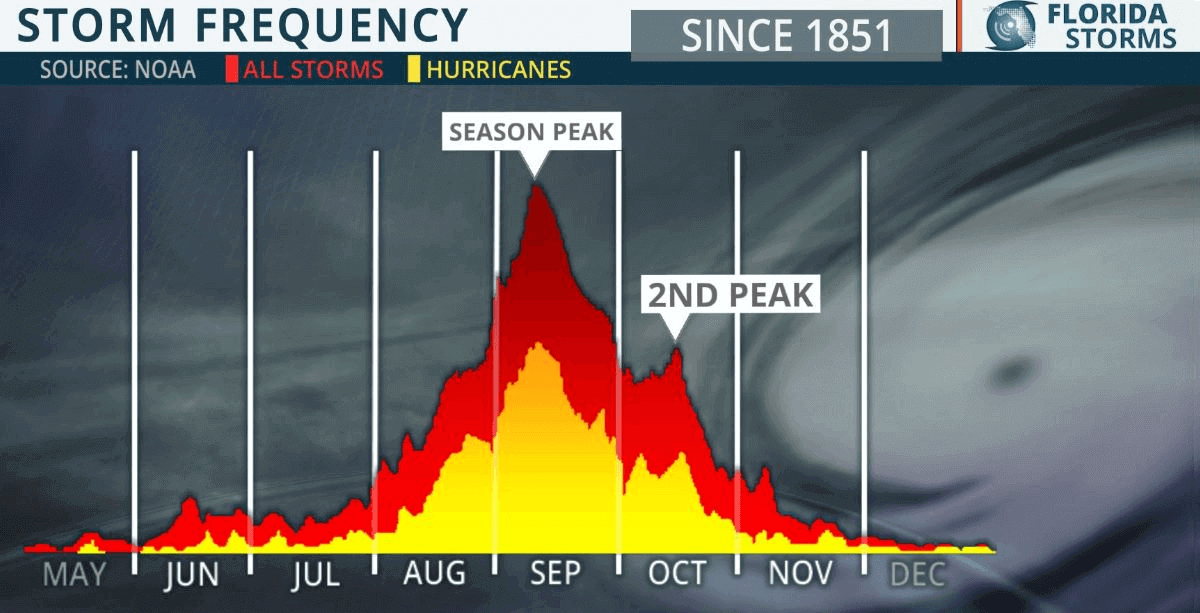
The general and more significant increase of tropical activity normally begins in early August. And even the first hurricane typically develops in mid-August, based on the long-term average.
So as the ongoing Tropical Storm Elsa was upgraded into a hurricane on Friday last week, this means that this has happened remarkably 45 days earlier than the average date of August 14th.
And also the usual increasing activity may begin earlier this year (end of July) as there are some mid-range trends that would suggest increasingly improved conditions coming up towards the end of the month. A major MJO wave* is building up in the tropical region of the Indian Ocean and might be arriving in the tropical Atlantic in 2-3 weeks from now. We will have a special article on this matter over the weekend – stay tuned.
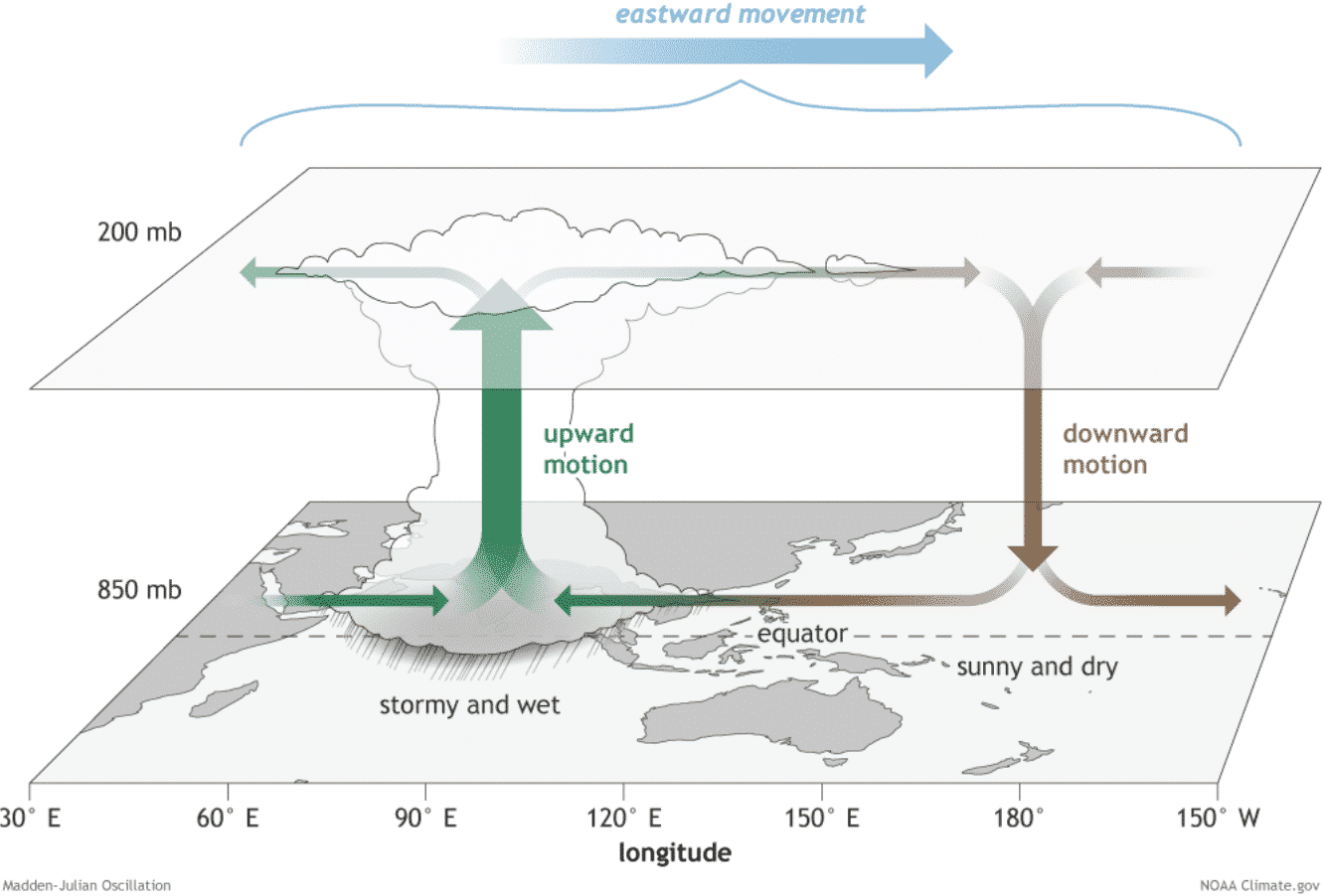
WHAT EXACTLY IS THE *MJO WAVE?
MJO wave, known as the Madden-Julian Oscillation (short: MJO), is a very important factor for tropical cyclone formation. MJO wave is the largest and most dominant source of short-term tropical variability around the world. It is an eastward-moving wave of showers and thunderstorms that circles the entire planet in about 30 to 60 days.
The chart below, provided by Michael J. Ventrice, Ph.D. represent an MJO wave with filtered VP200 anomalies for the current state and the forecast for a week ahead. The blue colors (cold) mean more favorable conditions for tropical cyclone development, while the red colors (warm) are representative of a less favorable state for tropical cyclogenesis.
Judging from the attached chart, we can see that favorable conditions are over Africa and the Indian Ocean while less favorable across the Pacific Ocean and also over the Atlantic. This can tell us that conditions on both sides of the Americas will not be supportive of additional tropical development.
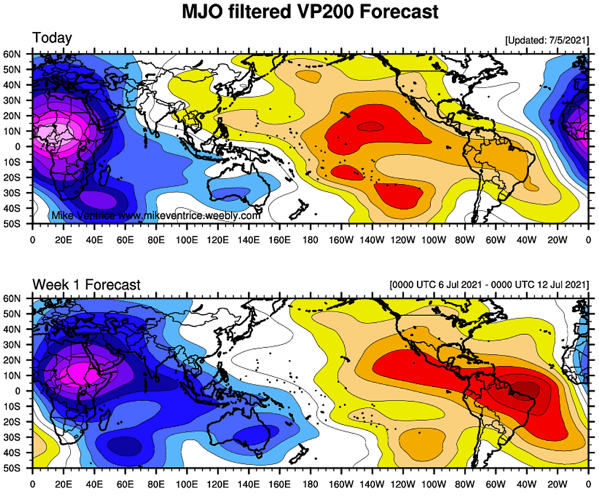
Note that the VP200 indicates a Velocity Potential (VP), an indicator of the large-scale divergent flow in the upper levels of the atmosphere over the tropical region. The negative VP anomalies (shaded in blue colors) are closely related to the divergent outflow from enhanced convective regions and often, if combined with low shear and high sea surface temperatures, lead to tropical cyclogenesis.
ELSA BRINGS FLOODING THREAT, STORM SURGE AND TORNADOES FOR FLORIDA PENINSULA
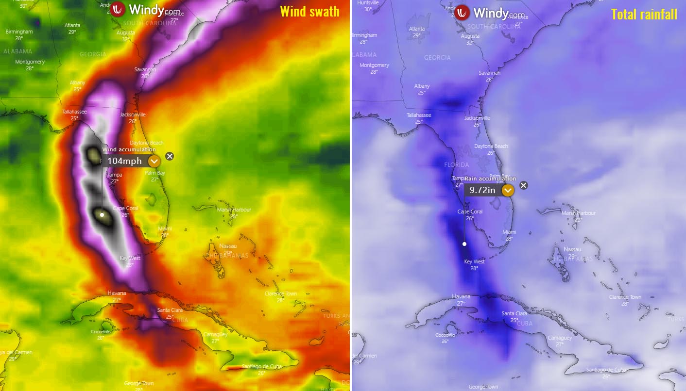
Attached below are the composite charts of both total rainfall and wind swath along the path of Elsa over the next five days.
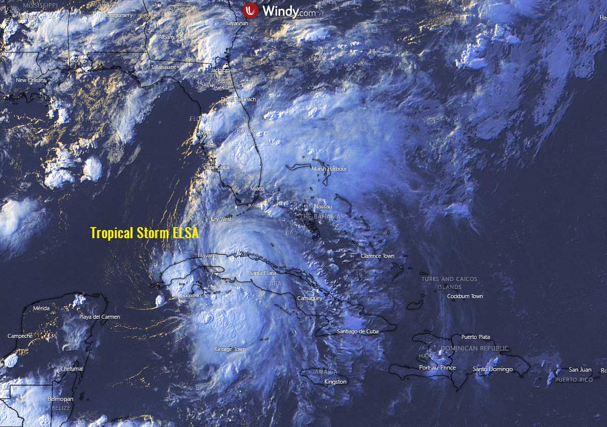
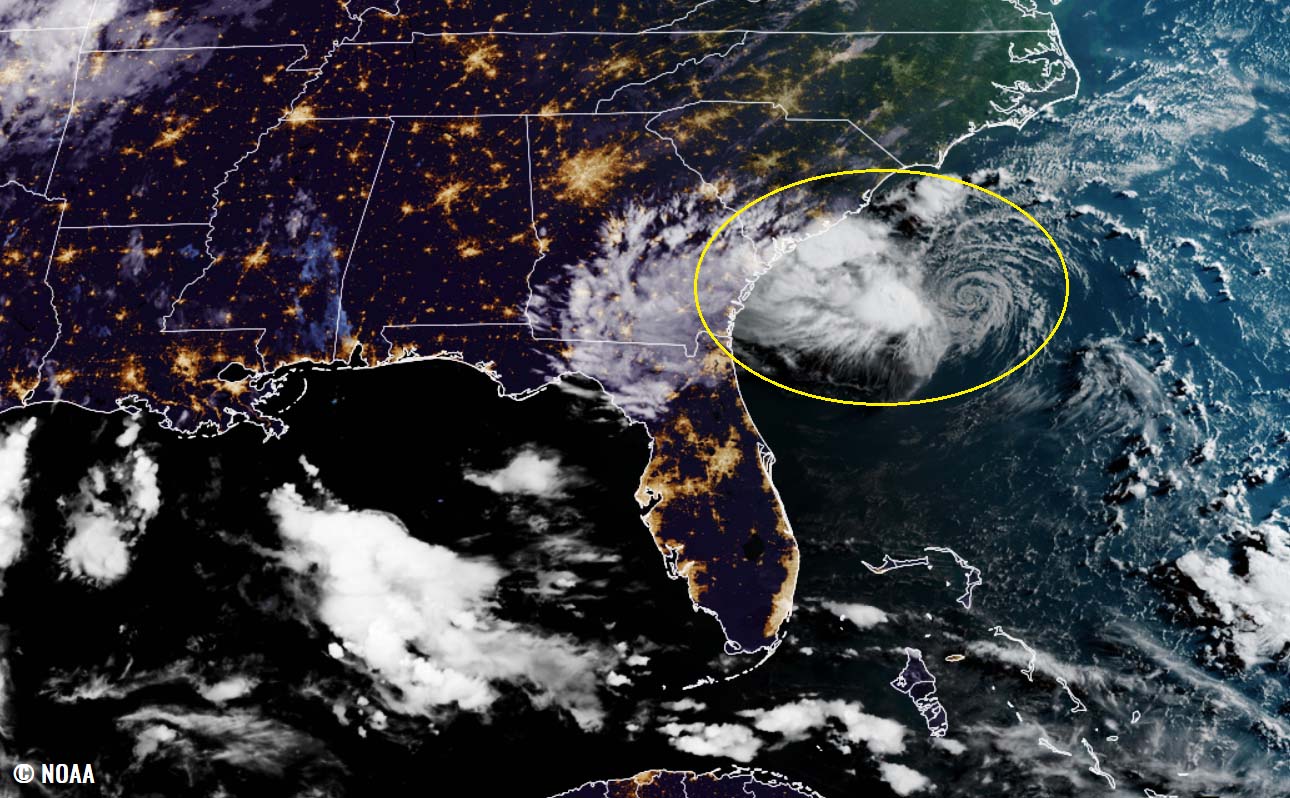
Above: Final light over Tropical Storm Elsa over Cuba, visible satellite spectrum. Credits: Windy
As Elsa approaches the Florida Keys, Florida Peninsula, and southeast Georgia through Wednesday, heavy rainfall may result in an isolated flash, urban, and minor river flooding. Considerable flooding possible in the southwest and western portions of Florida.
Parts of the Southeast United States, including the Florida Keys, Florida Peninsula, and southeast Georgia could see about 4-6 inches of rain while Elsa will track towards the northeast. Amounts of rain are high enough that this may cause flash flooding in the urban areas.
Tropical storm conditions are expected to spread across portions of the Florida Keys and the Florida west coast through Wednesday, where a Tropical Storm Warning is in effect. There is also a risk of tropical storm conditions along portions of Georgia and the Carolinas coastal areas on Wednesday and Thursday.
A life-threatening storm surge will be possible near and to the immediate east of Elsa’s circulation.
According to the National Hurricane Center (NHC), the storm surge could reach 2 to 4 feet above ground level along Florida’s western coast, from Bonita Beach to the mouth of the Ochlockonee River, including Tampa Bay. Additionally, a storm surge of 1-3 feet above ground level is possible in southwest Florida from Flamingo to Bonita Beach and in the Florida Keys from Ocean Reef to the Dry Tortugas.
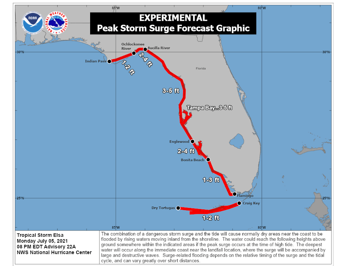
These also include Florida Bay, as well as along the Panhandle coast from the mouth of the Ochlockonee River to Indian Pass.
Another threat that is quite typical during the tropical cyclone landfall timeframe, is waterspouts or even tornadoes inland across Florida Peninsula from Tuesday night or Wednesday. As the center of Elsa nears the landfall point, wind shear increases across its northeast and southeast quadrants. It could be enough to support some brief supercell tornadoes.
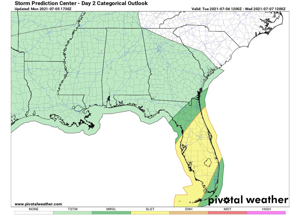
The chart above is the Storm Prediction Center’s (SPC) convective outlook for Tuesday. An SLGT (slight) risk has been issued for parts of the Florida peninsula as a corridor of strongest low-level shear spreads across the peninsula during the day and into Tuesday night. The stronger convection developing in the outer bands east of Elsa’s center will be capable of producing a few tornadoes.
After the landfall, Elsa will begin accelerating towards the northeast and track through the Carolinas and southeast Virginia late Wednesday into Thursday, ejecting into the Atlantic Ocean Thursday night.
WHAT’S NEXT FOR THE ATLANTIC HURRICANE SEASON AFTER ELSA?
For this year, the World Meteorological Organization (WMO) set a list of 21 tropical cyclone names that will be in use during the Atlantic hurricane season 2021. The list has started with Ana and ends with Wanda.
So far, four storms are already done – Ana, Bill, Claudette, and Danny.
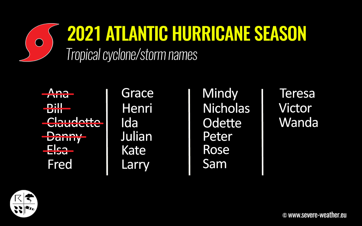
Tropical Storm Elsa is the 5th named storm, and has formed on July 1st and was the earliest 5th named tropical cyclone of the Atlantic hurricane season on record. The storm was then upgraded into the 1st hurricane of the season in the eastern Caribbean on Friday, reaching its peak as a Category 1 hurricane. And downgraded back to a tropical storm strength a day after.
Note: The tropical cyclone names list is used in rotation and re-cycled every 6 years. This means that the tropical storm names list of 2021 will again be in use in 2027.
What is the latest Atlantic Hurricane Season 2021 prediction?
The recent seasonal forecast for the Atlantic Hurricane Season this year hints that the already above-normal and very active season will continue. As we can see, it had a very fast start once again. Elsa becoming 5th named storm on July 1st was just one example.
The NOAA’s Climate Prediction Center (CPC) is forecast says that a 60 % chance of above-average activity exists this year. NOAA forecasters are expecting 13-20 named storms, including 6-10 hurricanes and also 3-5 major (Category 3 or greater) hurricanes.
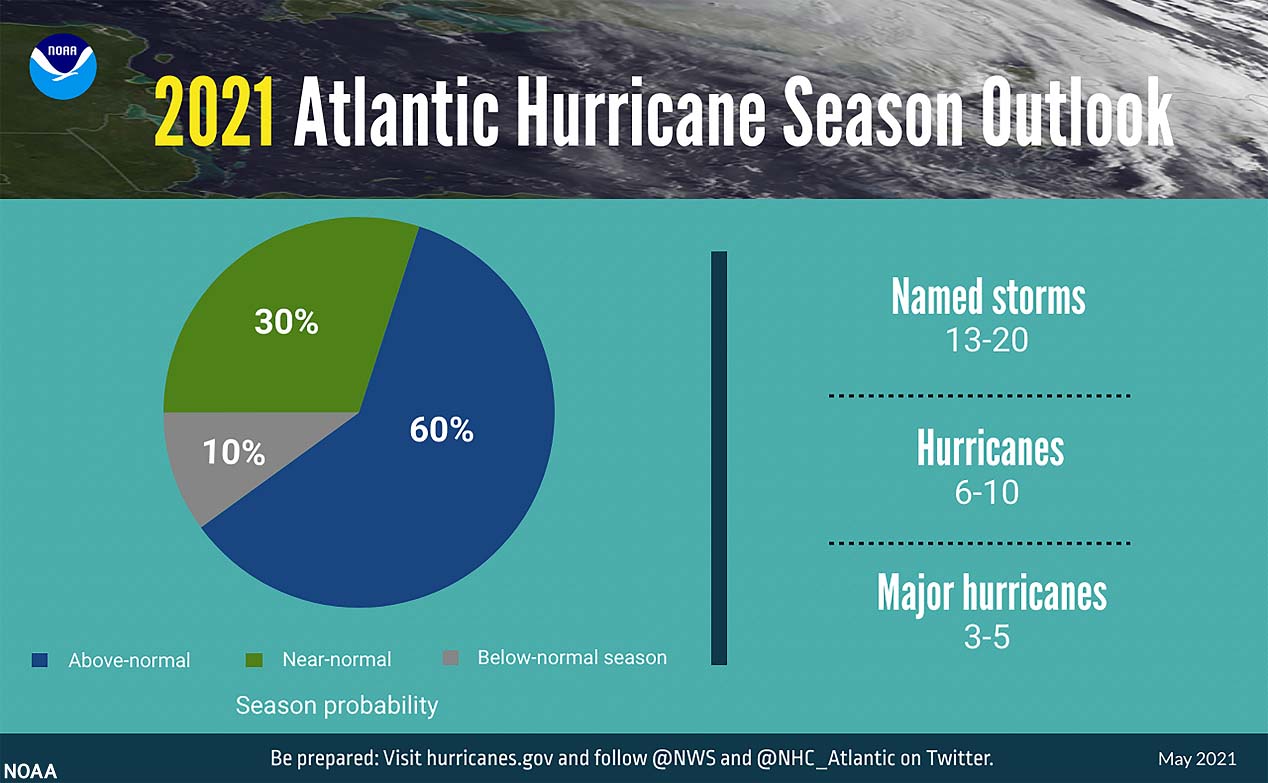
This goes well in line with the other forecasting centers’ predictions that are all in good agreement about the Atlantic hurricane season 2021 being yet another very active one. The Colorado State University (CSU) experts are expecting 18 named storms in 2021, the Weather Channel (TWC) calls for 19 named storms.
Tropical weather researchers have invented a special metric, that we use to express the energy that was used during the tropical cyclone’s lifetime. So we are able to compare every tropical storm or hurricane with the other, using the Accumulated Cyclone Energy (ACE index).
The official forecast by the CSU experts hints that the ACE index could be about 22 % more than a normal season for the 1991-2020 period, ending at around 150 during this year’s Atlantic hurricane season.
So what exactly is the ACE index (Accumulated Cyclone Energy)?
The ACE index is the abbreviation for the Accumulated Cyclone Energy, short: ACE. For the Atlantic Hurricane Season, the NOAA forecasters use 4 categories to classify storms by the ACE index:
- Extremely active – ACE index above 152.5
- Above-average – ACE index above 111
- Near-average – ACE index between 66 and 111
- Below-normal – ACE index below 66
To give your an imagination of what this means, here are some brief statistics. For example, the whole record-breaking Atlantic hurricane season 2020 has had an ACE of 184.5, so a quite well above the threshold for the ‘extremely active‘ category as we see above. The 2020 season was among the 10 most active Atlantic hurricane seasons based on the ACE index.
Note: The highest ACE index for the Atlantic hurricane season is 258, which occurred in 1933. The extremely active hurricane season 2020 also had a high ACE. 250 was at the end, thanks to very high and long-lasting tropical cyclones. 2nd highest after last year. 2020 had 30 named storms but quite a lot of ACE as we see, so this just shows that a high number of storms doesn’t necessarily reflect into a very high final value of the ACE index.
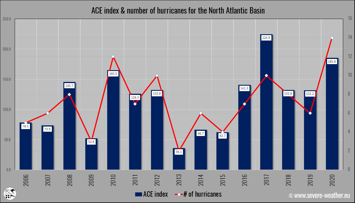
Above: The recent 15 hurricane season ACE final values and the related number of hurricanes in that particular year.
So far, the Atlantic hurricane season 2021 has already generated 9 ACE which is the 4th most ACE by Atlantic hurricane season by July 5th over the past 60 years. Only three years in history – 1966, 1968, and 2012 – made higher Atlantic ACE through this date.
***The images used in this article were provided by NOAA NHC, Tropical Tidbits, and Windy.
SEE ALSO: