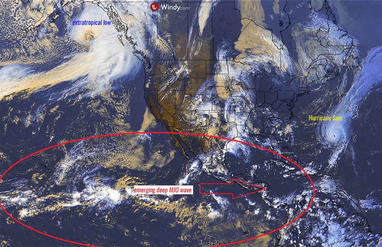
Hurricane Sam remains a powerful high-end Category 4 storm, passing near Bermuda this weekend, driven by extremely warm Atlantic waters and gradually emerging atmospheric MJO wave from the west. The 2021 Atlantic Hurricane Season still has two months to the official end, but the Accumulated Cyclone Energy (ACE) has already met NOAA’a above-average season definition. This is the 6th above-average year in a row. Sam will turn into North Atlantic and towards Europe as a powerful extratropical storm next week.
During this week, hurricane Sam underwent some extremely rapid intensification of its maximum winds and bottomed out with the central pressure at nearly 930 mbar. Sam is the 7th hurricane of the 2021 season for the Atlantic Basin, surpassing the major hurricane Ida and became the most powerful hurricane of the year.
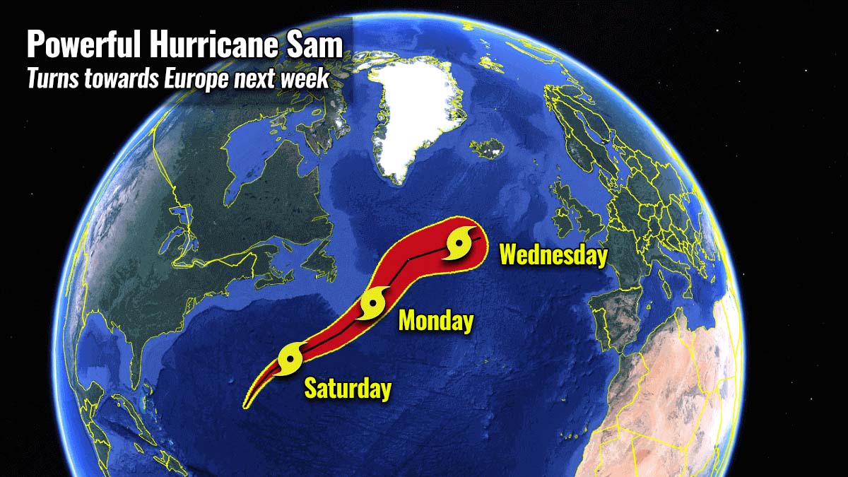
Hurricane Sam remains in still very favorable oceanic and environmental conditions, allowing it to maintain its powerful strength of a Category 4 with around 140-150 mph sustained winds. Sam will be traveling to the east of Bermuda this Saturday.
After Monday, a gradual turn will bring it into North Atlantic through the mid-next week and transform the hurricane into an intense extratropical cyclone before turning towards Europe.
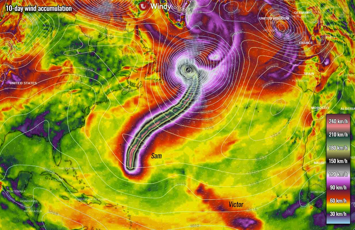
Also this week, another Tropical Storm Victor has formed southwest of Cabo Verde, becoming the 20th named tropical cyclone of the Atlantic Hurricane Season 2021. Only one name is left, that is Wanda, and could form soon – potentially in the Caribbean late next week. Then, a supplementary list of tropical cyclone names will be needed until the end of the season.
EXTREMELY WARM CARIBBEAN AND WESTERN ATLANTIC WATERS ARE CONCERNING THROUGH OCTOBER
The sea temperatures of the Atlantic Basin are still extremely warm than normal this early October, with a strongly positive anomaly of up to 2-4 °C or even more in some areas. Including the western Atlantic, the Caribbean region, and part of the Gulf of Mexico.
The warmest pockets of sea waters can be found around the Lesser Antilles, Cuba and Jamaica, the Bahamas, and around the southern Florida peninsula.
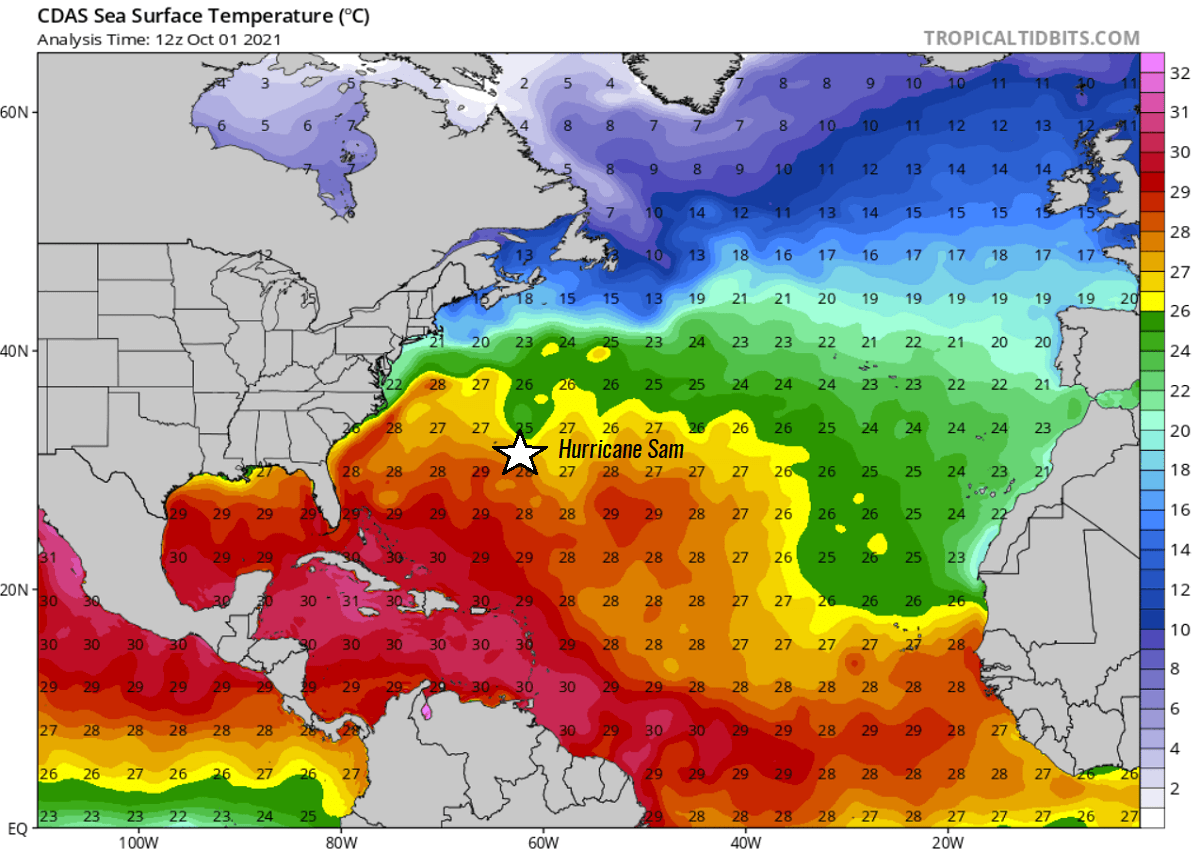
The sea temperatures in this part of the western Atlantic are at extremely high values as seen on the chart above, around 29 to 31 °C, which is extremely hot for early October. And such temperatures are also forecast to remain in a similar range at least through mid-October.
Generally, the very warm water temperatures, when combined with strong upper-level pattern support, normally lead to very rapid to even explosive development of tropical cyclones, they become more intense as well. These conditions are often found during the final months of the Atlantic hurricane season when seas are the warmest.
We have prepared a high-resolution video animation above, indicating how the Atlantic basin waters have been warming up over the recent week. This is one of the main reasons why the tropical Atlantic has been so hyperactive since early August and continues into early October in this hurricane season.
Extreme hot oceanic waters are a direct effect we can see with hurricane Sam this week, a rapid to explosive strengthening into a high-end Category 4 storm with 155 mph winds, then maintaining its strength of Category 3 or greater for more than 7 days already.
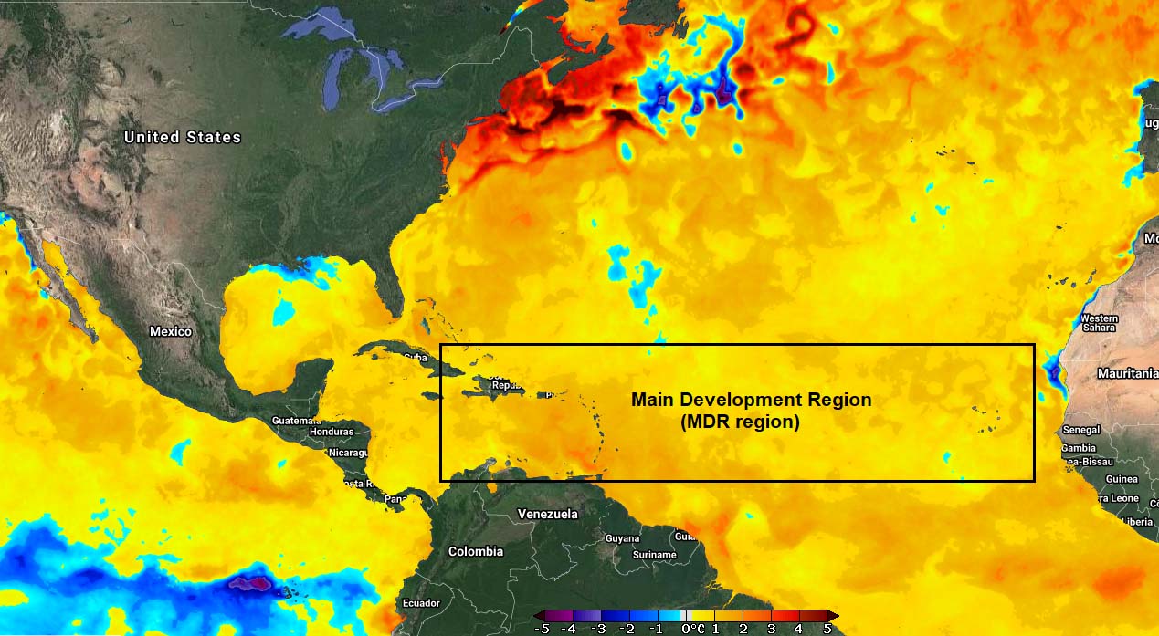
The oceanic water temperature is also anomalously warmed up across the so-called MDR region (Main Development Region). A virtual region that extends between the west coast of Africa and the Caribbean Sea. The majority of tropical cyclones develop during the Atlantic hurricane season.
OCTOBER WILL BE DRIVEN BY A MAJOR ATMOSPHERIC MJO WAVE
The two most important ingredients for tropical activity are the very warm oceanic waters fueling the convective storms and strong upper-level support for rising (lifting) motion. We use the term atmospheric waves when we talk about the upper-level support for storms. The most important atmospheric wave for the tropical region is the MJO wave, known as the Madden-Julian Oscillation.
Below are some simplified graphics so we can first learn what exactly the MJO wave is and why is it so an important ingredient and large-scale feature in the tropical region around our planet The atmospheric MJO wave brings a significant influence to the activity during the Atlantic Hurricane Season. this means that it can completely suppress the systems but also can lead to a significant amount of storms and hyperactive tropical activity.

The tropical regions around the Earth have general weather dynamics pretty much different from the mid-latitude region weather. The mid-latitudes have frontal systems that include cold and warm fronts, while the weather in the tropical region mainly has convective activity (thunderstorms) and no fronts.
These convective thunderstorms are occurring within a very large-scale pressure and wind variabilities, and a lot of the activity is driven by ‘invisible’ waves or wave-like features in the atmosphere. The Madden-Julian Oscillation (MJO wave) is the perfect example of this and is known as the largest and the most dominant source of short-term activity in the tropical region around the world.
The satellite image over the Pacific and the Atlantic Ocean above is showing this MJO wave, moving east. This atmospheric wave consists of tropical disturbances of showers and thunderstorms. The atmospheric MJO wave circles the Earth in the equatorial region in about 30 to 60 days.
The Madden-Julian Oscillation wave has two parts, one is the enhanced rainfall (wet phase) that leads to support of a tropical development and the other part that suppresses rainfall and convective activity (dry phase). The horizontal movement of these air masses is known as the Velocity Potential (VP), an indicator of the large-scale divergent flow in the upper levels of the atmosphere which allows the upward motion (convection) of the storms.
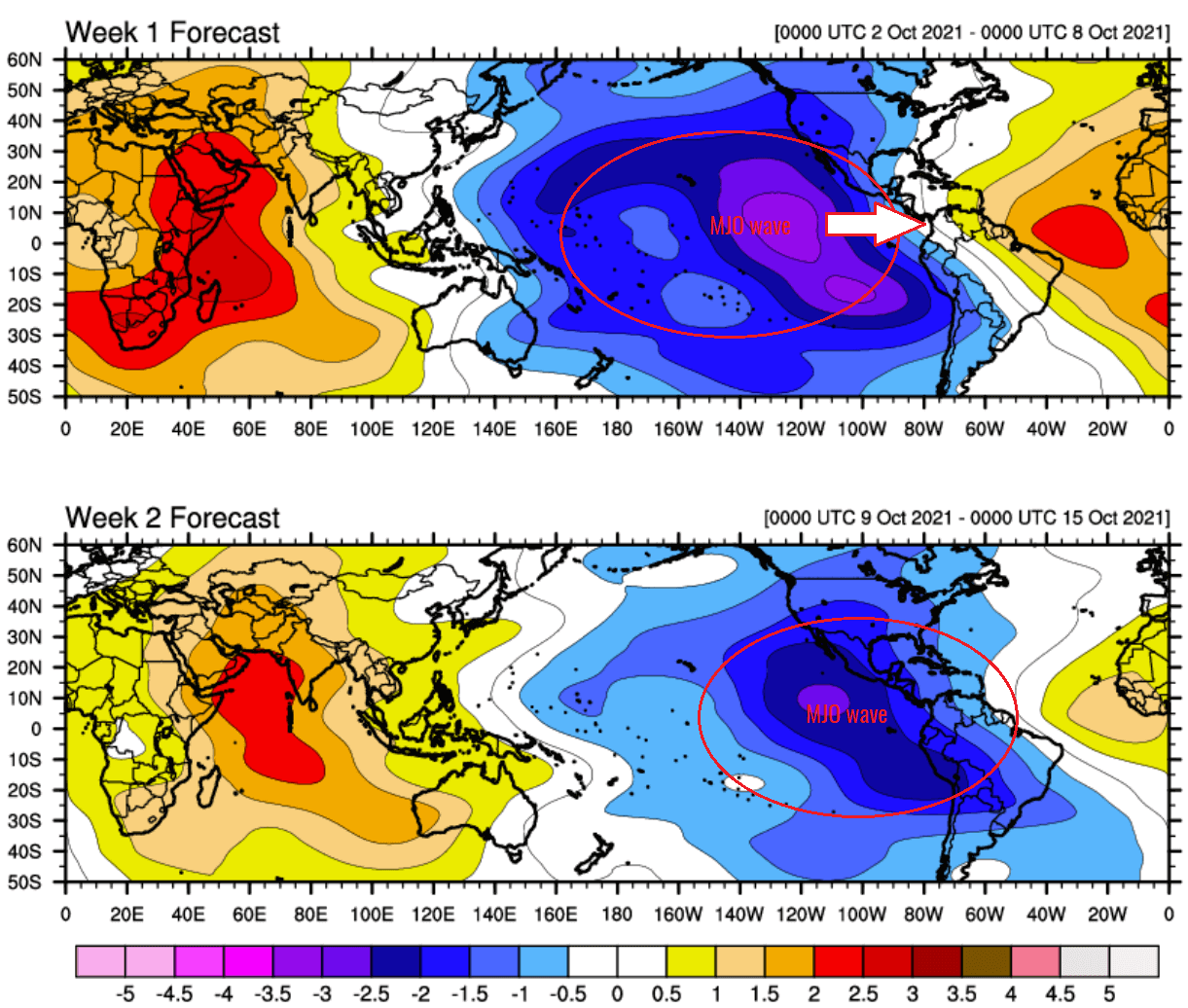
The attached map above, provided by Michael J. Ventrice, indicates a textbook major and a deep MJO wave (dark blue tones) moving from the eastern tropical Pacific into the Caribbean region and western Tropical Atlantic over the first half of October. The deeper the wave (darker blue tones) is, the higher support for tropical conditions follows for a period of few weeks.
Conditions have gradually begun improving through late September, helping Hurricane Sam to take advantage of these significantly better conditions in the upper levels and lead to its long-lived activity and powerful strength. The general weather pattern has brought a low wind shear environment that is also leading to very rapid development, as we could see with Sam last weekend.
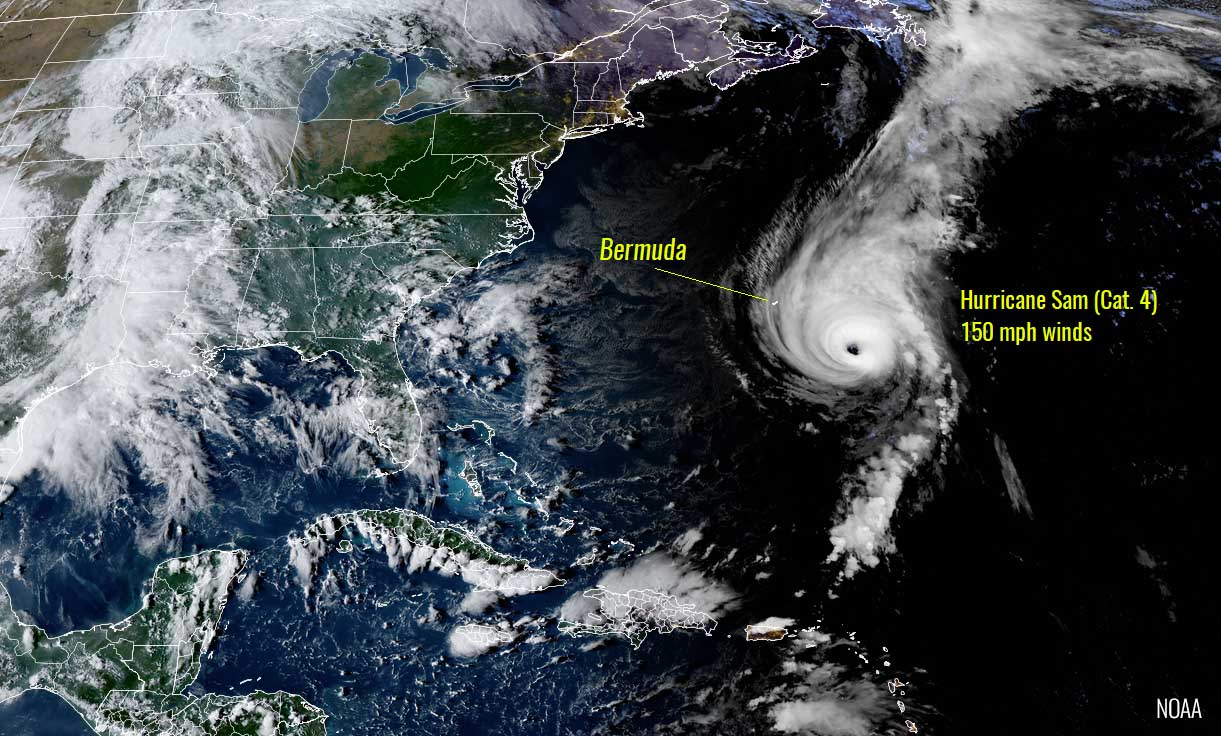
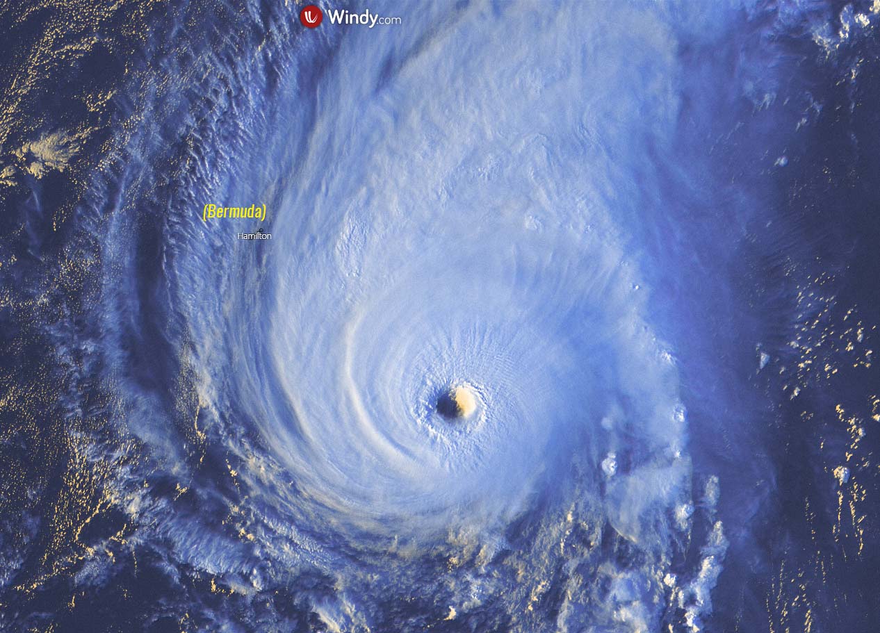
MAJOR HURRICANE SAM MISSES BERMUDA, BUT REMAINING A HIGH-END CATEGORY 4 STORM
Extremely warmer than normal Atlantic waters and the emerging deep atmospheric MJO wave aloft we talked about above have allowed hurricane Sam to become the most powerful and long-lived tropical system of the Atlantic Hurricane Season 2021. Sam has reached its peak last Sunday with 155 mph winds after an extremely rapid intensification in about 36 hours.
Since then, Sam was maintaining a powerful Category 4 intensity for most of the time, with just temporal fluctuations into a Category 3 strength due to the Eyewall Replacement Cycle (EWRC). It already has 7 consecutive days under the belt as being a major hurricane (Category 3 or greater). On Friday, Sam was on its closest approach to Bermuda, passing to its east.
Note, that for the tropical or mid-latitude cyclones, we define a rapid intensification rate when an increase in a storm’s maximum sustained winds is of 35 mph or greater within a period of 24 hours. Hurricane Sam has almost doubled that, thanks to the very hot waters the system grazed into during the last weekend.
In recent days, Hurricane Sam was undergoing several Eyewall Replacement Cycle (EWRC) and is now at full power again. Sam is traveling due north to the east of the Bermuda island which is under the Tropical Storm Warning.
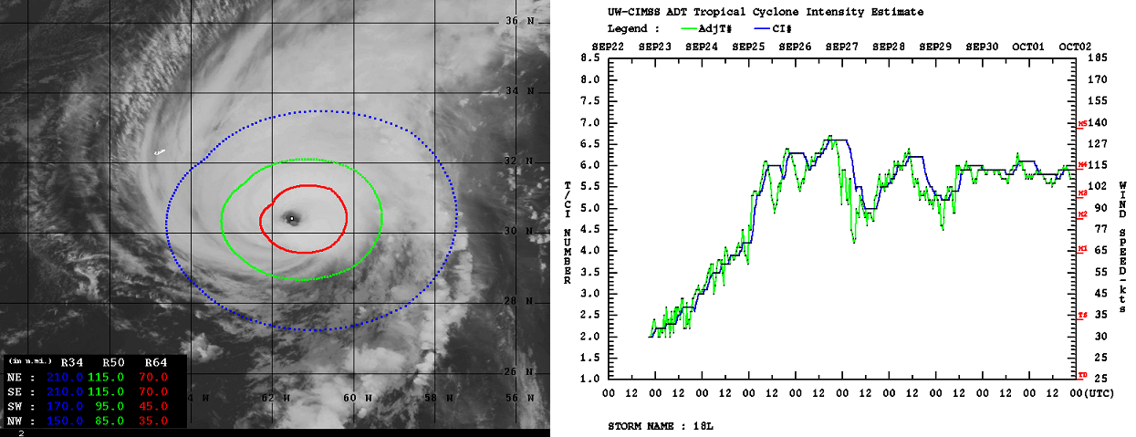
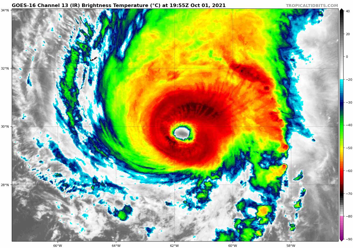
The tropical-storm-force winds are expanded across the radii of 90-120 miles around the center, while hurricane-force winds up to 70 miles. The right chart hints at how Sam is maintaining major strength since the last weekend.
The minimum central pressure in Sam’s eye has bottomed out just slightly above 930 mbar during its peak intensity. Such a central pressure drop Sam had was also the fastest on record for any storm being so east in the tropical Atlantic during September.
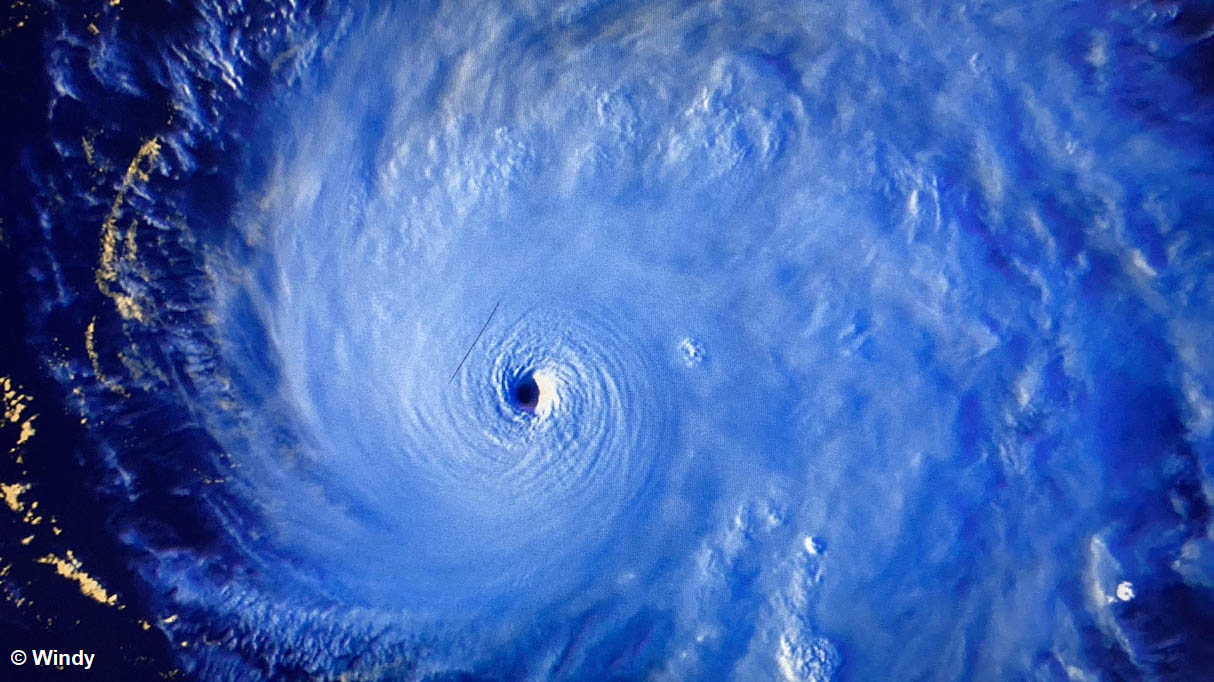
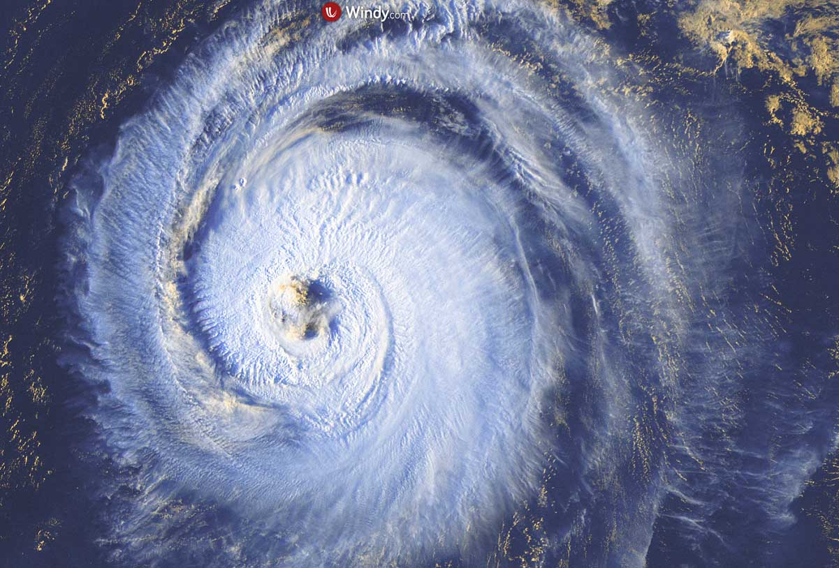
These data were also confirmed by the NOAA hurricane hunters aircraft. A few passes and dropsondes in the eyewall have shown extremely intense winds of 155 mph being the highest. The satellite image above was taken during the peak strength.
An infrared satellite image of Hurricane Sam indicates that the eye is still very distinct and there are several mesovortices evident at times. In addition, the microwave satellite images also show a closed and symmetric eyewall, supporting its powerful Category 4 intensity. The NOAA aircraft has recently measured peak flight-level winds of 175 mph, which corresponds to around 150 mph surface winds.
Major hurricane Sam is a solid, high-end Category 4 storm and is not expected to intensify any further. But will remain over very warm oceanic waters for a few more days, while wind shear is low. This should allow it to remain a major hurricane for another day or two before a gradual weakening begins.
Large swells generated by Sam will impact the northern Leeward Islands, the Greater Antilles, the Bahamas, and Bermuda during the next couple of days and also reach the United States East Coast and Atlantic Canada on Saturday. These swells could cause life-threatening surf and rip current conditions.
HURRICANE SAM WILL BECOME EXTRATROPICAL LOW EARLY NEXT WEEK, THEN TURNING TOWARDS EUROPE
After passing Bermuda this weekend, hurricane Sam is forecast to take a northeast turn into the North Atlantic. Sam is then expected to slowly weaken as it moves over progressively cooler waters and into an environment of stronger shear. The hurricane will likely begin the extratropical transition in a couple of days when it crosses the 26 degrees C isotherm, and this transition is expected to be completed shortly after 72 hours.
The attached charts below are indicating the future track of Sam that is forecast to continue its path across the North Atlantic as an extratropical cyclone next week. The trajectories by both ECMWF (left) and the GFS (right) models hint it should travel towards Europe.

Notice, that the majority of the model forecasts keep the hurricane Sam at a powerful Category 3 or greater strength over the next few days. Even at times when the transition to extratropical storm occurs in the Northwest Atlantic sometime from Monday to Tuesday.
How intense the system will be next week is yet not undefined completely, as it strongly depends on where and when the transition to extratropical cyclone takes place. Th forecast ECMWF model chart below is showing a large swath of intense hurricane-force winds until the transition, somewhere to the east of Newfoundland on Tuesday.
This also hints that there will very likely be no interaction (landfall) of Sam with Atlantic Canada and Sam will remain over open waters of North Atlantic. After the extratropical transition, Sam will be a powerful cyclone and will make a turn towards Europe. Most of the model forecasts do hint its path may continue until Iceland, but some variants also bring it to west-northwest Europe late next week.
Surely a need to continue following the system as it turns towards the European continent. This is the first (extra)tropical system that will take a turn towards Europe this Atlantic Hurricane Season 2021.
U.S. MAINLAND AND FLORIDA LANDFALLS DURING THE LATE ATLANTIC HURRICANE SEASON
During the late Atlantic Hurricane Season, October is typically the 2nd month (after September) with the most active period when the majority of the tropical cyclone formations occur. At the same time, the tropical activity is gradually shifting into the western Atlantic and the Caribbean region as we head deeper into the fall months. Tropical systems then also have higher chances of turning towards the United States mainland.

The Florida peninsula has a statistical peak of tropical storms or hurricane landfalls from mid to late October. The late-season tropical activity typically clusters on the Florida Gulf Coast in October.
The long-lasting hyperactive period of tropical activity in the Atlantic Basin brought 7 hurricane formations between mid-August and the end of September this season. This was mainly due to the extremely warm sea waters that are now additionally boosted with the incoming atmospheric MJO wave aloft. A combination of parameters is expected to generate more dangerous tropical systems in the typical October peak of the activity.
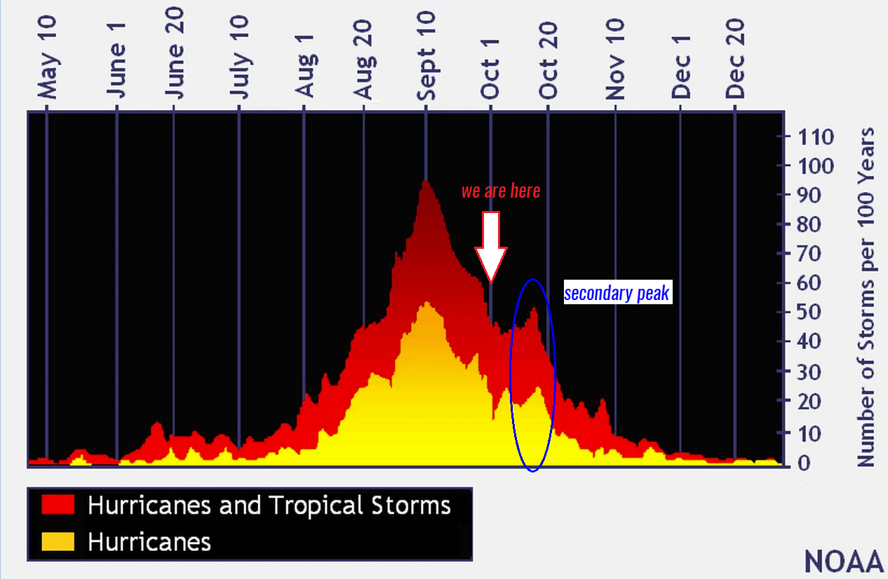
As we can see from the attached chart above, the tropical cyclone frequency in a typical Atlantic Hurricane Season has two peaks. The seasonal highest activity during early September is pretty obvious, but also October has an eye-catching peak. Note that these numbers are averaged over the last 70 years and represent the number of storms per day per 100 years.
The secondary peak of the activity in October, quite often develops intense hurricanes that move across the Caribbean region and turn towards the U.S. mainland during the late Atlantic hurricane season months. 2020, for instance, had powerful and destructive hurricanes hurricanes Delta, Epsilon and hurricane Zeta, all occurring in October.
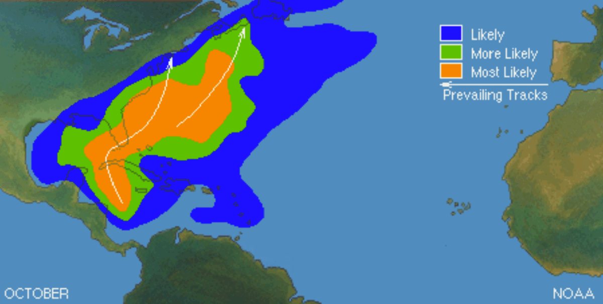
As we discussed above, the main shift in dynamics and weather patterns between September and October is the shift of the tropical activity closer to the Caribbean and the United States, making Florida in the zone of potential hurricane impacts. The white arrows on the map indicate the prevailing tracks of tropical cyclones (storms or hurricanes) in October. normally occur.
A typical tropical cyclone development with the majority of these formations is therefore found in the western tropical Atlantic. This leads to the higher potential for the landfall of tropical systems along the U.S. mainland, the Florida peninsula, and the East Coast as well.
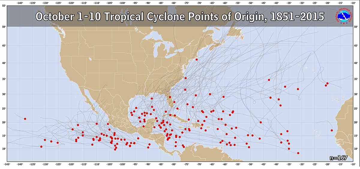
The first 10 days of October have the highest tropical cyclone formations across the western Atlantic and the Caribbean region, also the Gulf of Mexico. These areas are then the most vulnerable this month and despite the peak of the Atlantic hurricane season is already more than a month away, tropical systems have to be closely watched further.
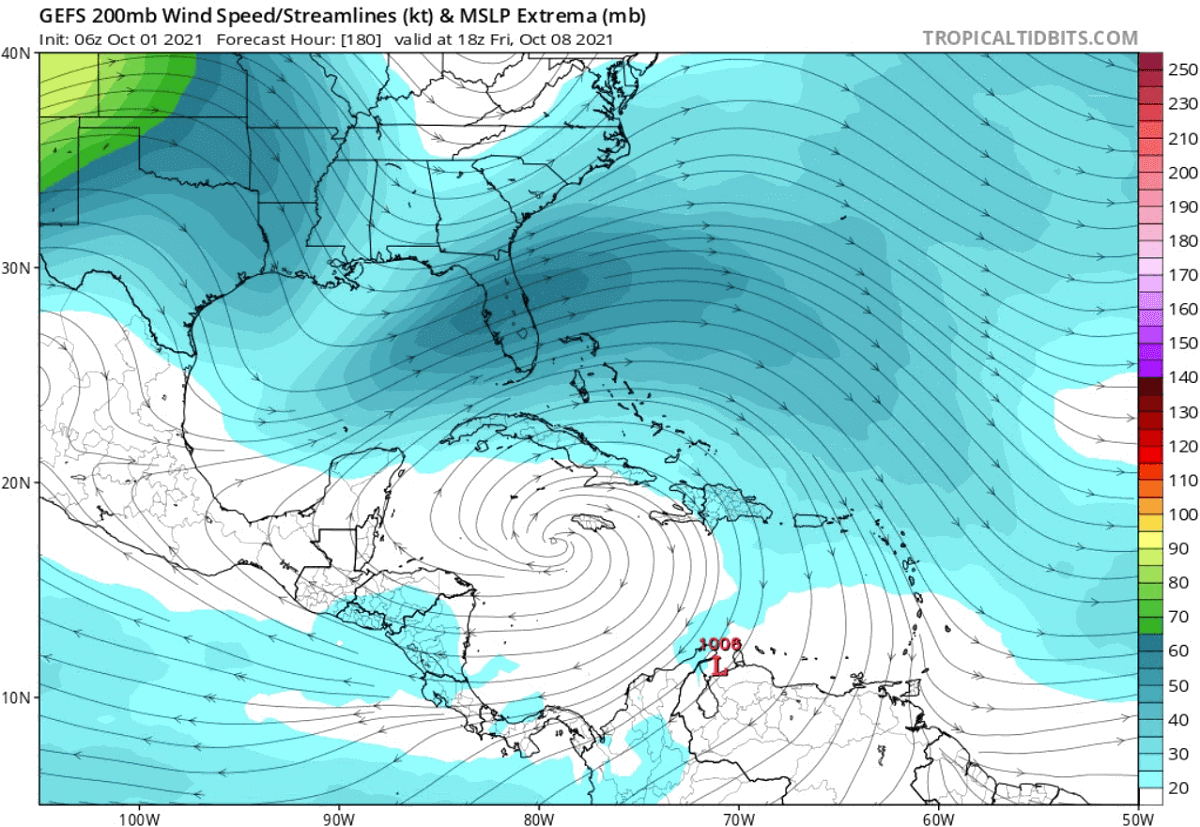
The mid-term weather models are already hinting at a potentially concerning weather pattern developing next week. An upper-level high (anticyclone) is forecast over the Caribbean region. This could increase the potential for tropical development, especially as we are expecting the MJO wave aloft to bring even better upper-level support.
Conditions are surely in place. If we remember the extremely warm seas of 30-31 °C over the Caribbean Sea and the atmospheric wave support, it might just need some time we will be watching a new tropical disturbance in this part of the tropics.
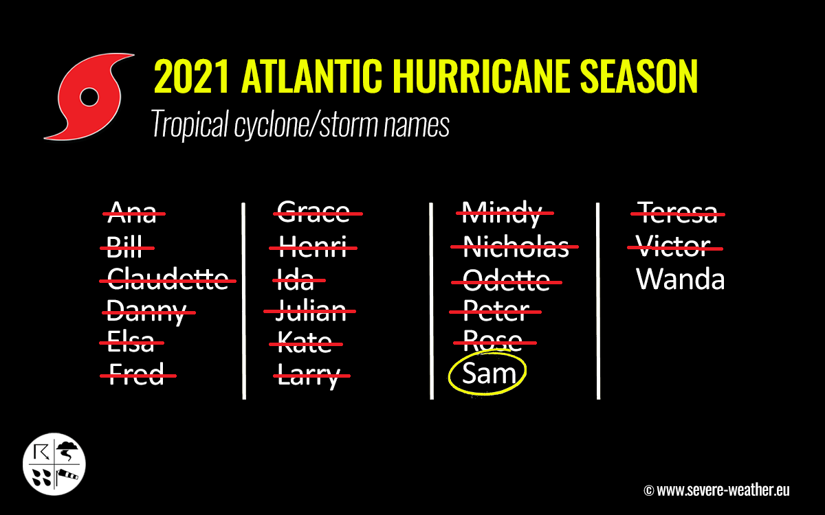
20 NAMED STORMS ALREADY UNDER THE BELT, ATLANTIC HURRICANE SEASON SOON ENTERS THE SUPPLEMENTARY LIST
With hurricane Sam, followed by a short-lived tropical storm Teresa, and Tropical Storm Victor this week, the hyperactivity of the Atlantic Hurricane Season is nowhere to its end. After the statistical peak over a month ago, the hurricane season is running at more than 80 % of the average number of named cyclones in a typical year in the Atlantic.
Sam is the 18th named storm of the Atlantic Hurricane Season 2021, Teresa was the 19th, Victor was the 20th.
According to dr. Philip Klotzbach, there are normally about 10.9 named storms by Sept 30th. Also 5.3 hurricanes, and 2.3 major hurricanes. With 20 named systems so far, the tropical activity in the Atlantic is well ahead of the typical schedule and this activity should remain above normal until the hurricane season is officially over.
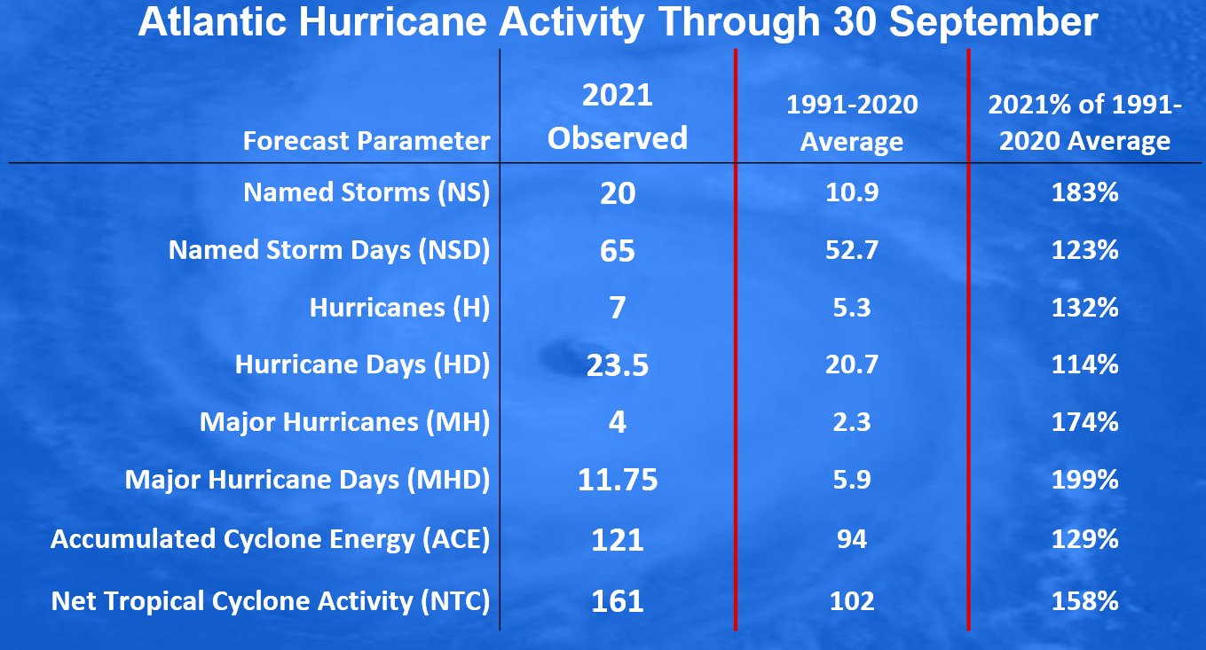
There have already been seven hurricanes and 4 major hurricanes besides Sam, Grace, Larry, and Ida were the others this year. So the hurricane statistics are also running much above normal. The chart below are the tracks of all 20th tropical cyclones in 2020.

Just recently, the NOAA seasonal outlook and Colorado State University (CSU) lead by dr. Klotzbach has updated their forecasts and both hints at the above-normal activity to continue in October and even into November. There are up to 10 more tropical storms possible, also up to hurricanes by the end of the season that officially ends on November 30th.
Some of these systems could also make landfall and impact the United States mainland in this period.
Now it is more than obvious that it is just a matter of time when the Atlantic Hurricane Season will graze into the uncharted territory, as even by a long-term average, more tropical cyclones follow in October and November. With only Wanda left from the official designated list, a supplementary list of tropical cyclone names will be needed this month.
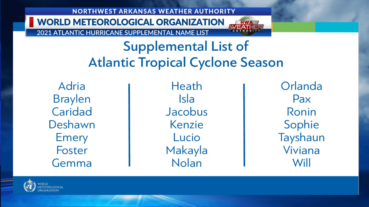
When the official cyclone names list is over, a supplementary list comes into use. This list of cyclones was predetermined by the World Meteorological Organization (WMO) in early spring this year, replacing the Greek Alphabet list that was in use for the most active years until now, 2005 and 2020.
The list brings much friendlier named storms, as using Greek alphabets made it quite difficult to track for many.
SAM PUSHES THE ATLANTIC HURRICANE SEASON 2021 ACCUMULATED CYCLONE ENERGY (ACE) MUCH HIGHER
When we are monitoring the strength of the Atlantic Hurricane Season, we also use a special indicator that allows us to compare hurricane seasons throughout the years. A so-called ACE index is used for this matter. An ACE is an abbreviation for the Accumulated Cyclone Energy.
ACE is a technical metric that is used to express the energy that was used by a tropical cyclone during its lifetime. It is an integrated metric accounting for storm intensity and duration of cyclones.
During the Atlantic hurricane season this year, the number of tropical systems has been increasing extremely fast since the beginning, and many of them were intense. Just by the numbers, this means we are really not far behind the record-breaking hurricane season of 2020. But that is why it is advised to calculate the ACE index to see how the season is standing.
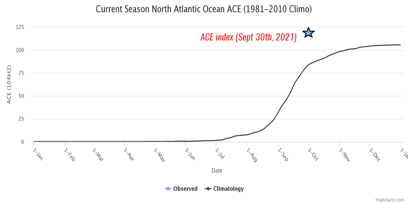
Until September 30th, the seasonal ACE index of more than 121 has already been accumulated by all the 20 named tropical cyclones during the Atlantic Hurricane Season 2021. The highest ACE of the season was collected by the major and long-lived hurricane Sam, which was already past 40 ACE on Friday.
Major hurricane Larry, the 2nd higher contributor to ACE, ended up at 32.8 ACE during its 11 days of activity grazing across the Atlantic Ocean. Larry made three times more ACE than each, Ida (10.8 ACE), Elsa (9.5 ACE), and Grace (9.1 ACE). Actually, both Sam and Larry alone produced more energy than all those three hurricanes together.
To give us an idea of where 2021 is standing, the whole Atlantic hurricane season 2020 made the total generated ACE of 185.8, quite well above the statistical threshold for the ‘extremely active’ ACE category, which is set at 152.5 for the Atlantic basin. With Sam being active as a major hurricane for a few more days, it will bring ACE much higher next week.
So based on just looking at the number of tropical cyclones in one statistical Atlantic Hurricane Season, the only similar season to 2020 was 2005. The ACE of the 2005 year ended up much higher, its final calculation was 250 ACE. Although the record-breaking hurricane season 2020 produced 30 tropical systems, 2005 did two less, 28. Their ACE was well apart.
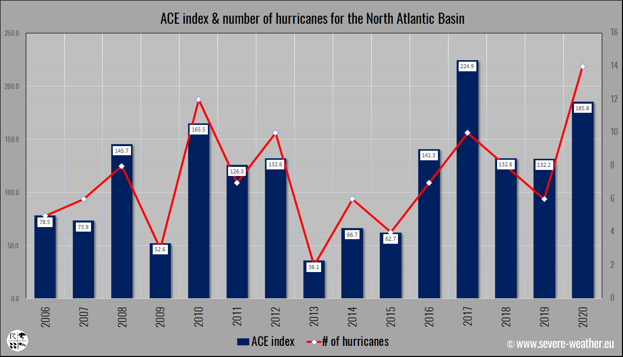
This chart above is showing the Atlantic 15 hurricane season activity since 2006, with ACE and the related number of hurricanes in that particular year. The rising trend of ACE in the recent year is pretty obvious, with the highest ACE in this period found during the Atlantic hurricane season 2017.
According to the remarkable analysis by Sam Lillo below, the trajectory increase of the 2021 Atlantic hurricane season systems look really very similar to the 2005 and 2020 surges in named storms. We are aware that both of those years had the highest number of named tropical cyclones in history, 2020 had 30 storms, 2005 had two less, 28 storms.
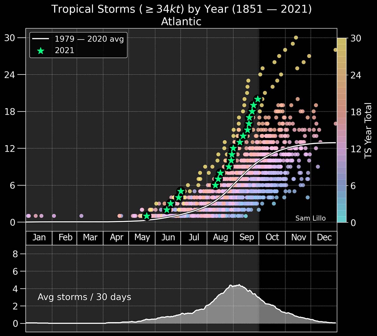
Can you see what the long-term statistics could bring us to the Atlantic Hurricane Season 2021 until it is finally over? Absolutely. If we just take the number of tropical cyclones in 2005 and 2020, the potential is there for another 7-8 systems by Nov 30th. That would put 2021 to around 28 named storms!
Also, just take a look at how steep is the increase of the 2021 graph particularly in the recent weeks. Each star marks those 20 named systems. The Atlantic hurricane season activity has really become hyperactive up since early August.
If you don’t want to miss any of our future updates, make sure to bookmark our website. If you found this article in the Google App (Discover) feed, feel free to hit the like button (♥) there to subscribe for more of our in-depth forecast discussions on various weather topics.
** Images used in this article were provided by WindyWeathernerds, and NOAA.
SEE ALSO: