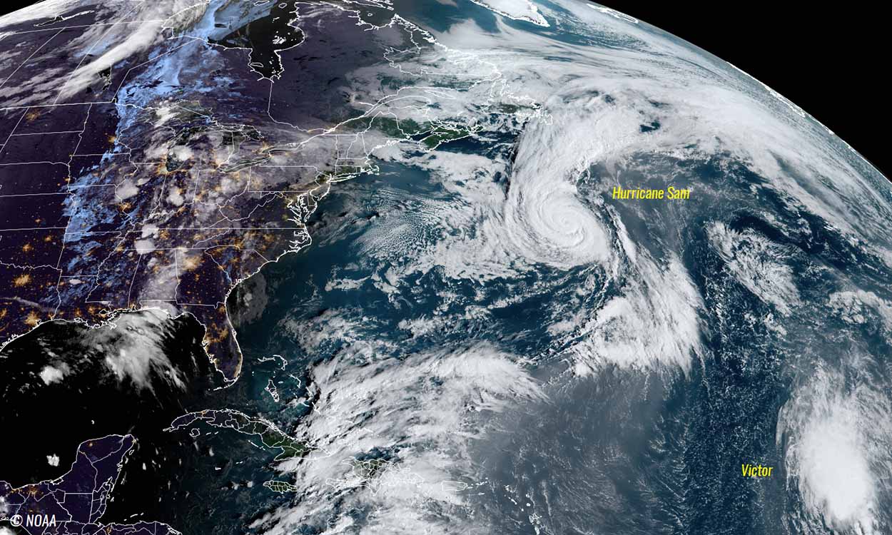
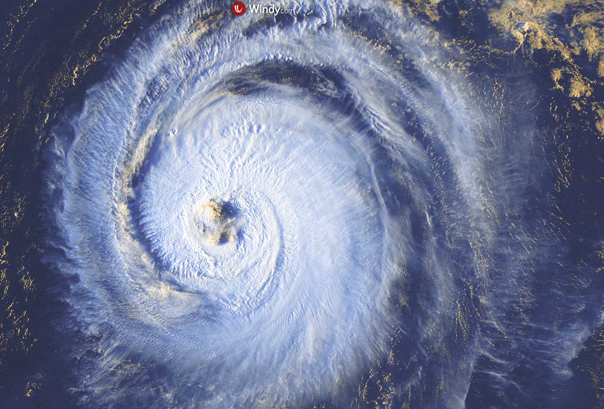
Hurricane Sam still looks pretty impressive storm, although it is now a Category 2. Sam missed Bermuda on Saturday and is now grazing deeper into the far North Atlantic, expected to transition into a powerful extratropical low before gradually turning towards a potential impact to Iceland late this week. Sam is the most intense and longest-lived storm of the Atlantic Hurricane Season 2021. With the emerging major MJO wave aloft, the hyperactive year is far from over.
About 14 days ago, we began monitoring a potent tropical wave ejecting off the West coast of Africa. On Sept 23rd, a Tropical Storm Sam was born, upgraded into a hurricane on Sept 24th, the 7th Atlantic storm winds greater than 75 mph this season.
Since then, more than 10 days after, the system is still grazing across the open Atlantic Ocean and it is forecast to continue until it reaches Iceland sometime late this week. Sam will become a very powerful extratropical storm after Tuesday.

Hurricane Sam has reached its peak intensity of 155 mph last weekend, a borderline Category 5 after undergoing extremely rapid intensification, and bottomed out its central pressure at 929 mbar. Sam is also the strongest hurricane of the year.
The system is moving across gradually less favorable oceanic and environmental conditions, but it keeps maintaining a powerful strength until it is forecast to take an extratropical transition to the east of Newfoundland on Tuesday. Sam will then gradually turn father northeast, deeper into the far North Atlantic afterward.
Hurricane Sam is a perfect example of how the much above normal waters of the Atlantic can support rapid intensification, long-living systems, and a high number of tropical cyclones during this hyperactive Hurricane Season 2021. This activity has been ongoing since early August and is also forecast to continue into October.
By mid to late this week, remnants of Sam will act as a large and intense extratropical cyclone and will continue moving towards Iceland where an impact is forecast to take effect towards the end of the week.
Meanwhile, more than a thousand miles to the south-southeast of Sam, Tropical Storm Victor has been downgraded into a depression while moving into an unfavorable area in the wake of Sam. This means the Atlantic Hurricane Season 2021 is only one name away to reach the end of the designated tropical cyclone list.
A supplementary name list of storms will be needed until the official end of the season.
SAM TAKES ADVANTAGE OF WARM ATLANTIC TO HOLD ITS TITLE AS THE LONGEST-LIVED STORM OF THE HURRICANE SEASON
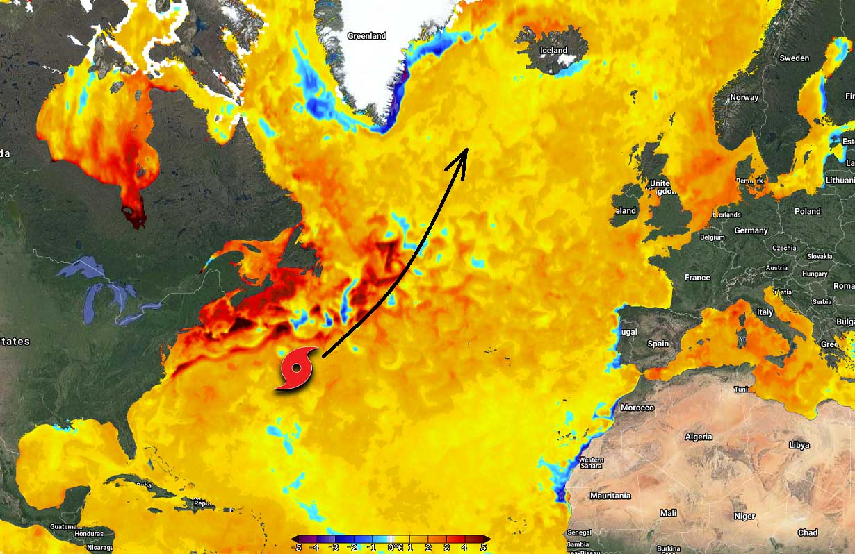
After its long-lasting activity traveling through the extremely warm sea temperatures of the Atlantic Basin over the last 14 days, Hurricane Sam is now accelerating across the Northwest Atlantic. Thanks to the overall much above normal oceanic conditions for early October, the system is forecast to maintain its powerful strength for at least another 5 days.
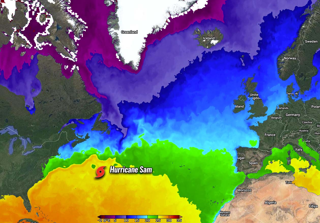
The Atlantic Ocean this hurricane season is generally very warm, with a strongly positive anomaly of up to 3-4 °C above normal in some areas of the western Atlantic, the Caribbean region, and also across part of the Gulf of Mexico. Hurricane Sam is now soon ejecting out of the warmest seas (note that 26 °C is usually the threshold for tropical systems development).
Sam’s intensity is forecast to take advantage of these warm waters and keep the system pretty strong, at least for another day or two until the transition into an extratropical low will take place. Keep in mind that very warm water temperatures are when combined with strong upper-level pattern support, normally leading to stronger tropical cyclones.
The oceanic water temperature is actually extremely warm along the Gulf Stream, the area of the Atlantic where hurricane Sam will be crossing on Monday. Exactly where the extratropical transition will take place. Sea surface temperatures are nearly 5 °C above normal for this time of the year.
Notice that also the whole North Atlantic remains warmer than usual. And this is pretty much a strongly concerning signal that the final two months of the Atlantic Hurricane Season could be very active. Especially as we are now monitoring a large and very deep atmospheric MJO wave that is forecast to boost the activity throughout the month of October.
OCTOBER IS HERE, WHAT TO EXPECT AS ATMOSPHERIC MJO WAVE EMERGES?
There are two most important ingredients in the tropical regions: having very warm ocean temperatures that are fueling the convective storms and strong upper-level support for rising motion (convection) needed to support tropical development. We use the term atmospheric wave when discussing this support aloft, the most important of this kind is the MJO wave, known as the Madden-Julian Oscillation.
But what exactly is the MJO wave and why is it so an important ingredient in the tropics?
The Madden-Julian Oscillation is a large-scale feature in the tropical region that circles the Earth in the equatorial region in about 30 to 60 days. It results as a significant booster to the tropical activity during the Atlantic Hurricane Season.

The tropical regions around our planet have general weather dynamics that are quite a lot different from the mid-latitude region weather patterns. We are used to having frontal systems with cold and warm fronts in the mid-latitude regions, while the weather in the tropical region mainly has convective activity (thunderstorms) and no real fronts.
These thunderstorms are ongoing within a large-scale pressure and wind variabilities, a lot of the activity is driven by the ‘invisible’ waves in the atmosphere. MJO is such a wave and has two parts, enhanced rainfall (a wet phase that boosts the tropical development) on one side and the suppressed convective activity (dry phase) on the other side.
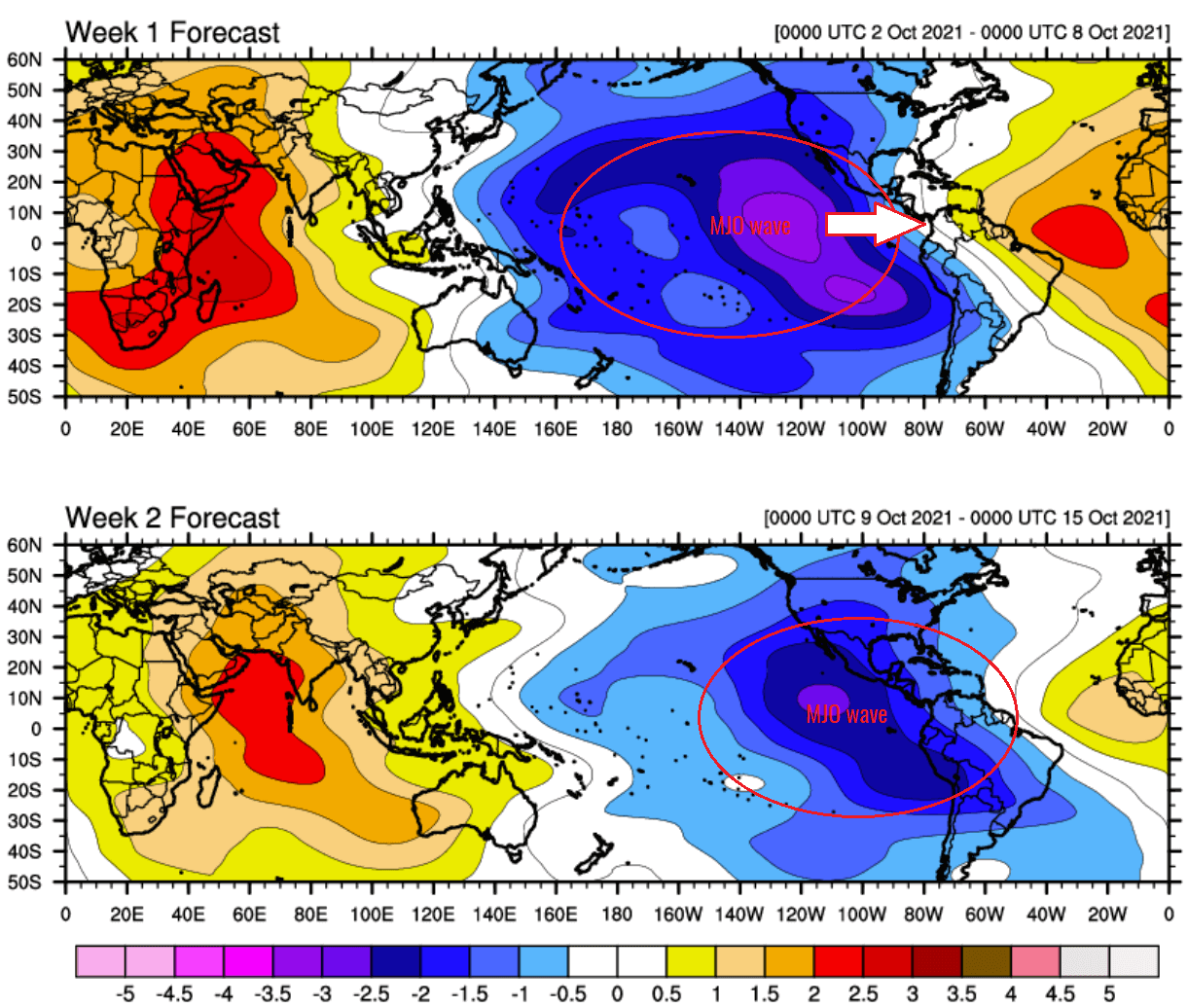
The horizontal movement of these air masses is known as the Velocity Potential, an indicator of the large-scale divergent flow in the upper levels of the atmosphere which allows the upward motion of thunderstorms (convection). The attached map above, provided by Michael J. Ventrice, indicates a deep MJO wave moving from the eastern tropical Pacific into the Caribbean region and western Tropical Atlantic through the first half of October.
Since late September, the general environmental support has been increasing and helping Hurricane Sam to become a long-lived storm with powerful strength. The general weather pattern with the emerging MJO is also resulting in a low wind shear environment that will remain in place for the following weeks this October.
HURRICANE SAM REMAINS AN IMPRESSIVE AND INTENSE CATEGORY 2 STORM
The very warm Atlantic Ocean waters and the gradually emerging deep atmospheric MJO wave aloft from the west have allowed hurricane Sam to become the most powerful hurricane of the Atlantic Hurricane Season 2021, also the longest-lived tropical system this year.
Sam has been changing its intensity back and forth over the past week, but it kept the major hurricane strength (Category 3 or greater) for nearly 8 days and finally been downgraded to a Category 2 storm this past Sunday. Only 3 hurricanes had a major strength for more consecutive days than Sam, those were Ivan (2004 – 9 days), Luis (1995 – 8.25 days), and Isabel (2003 – 8 days).
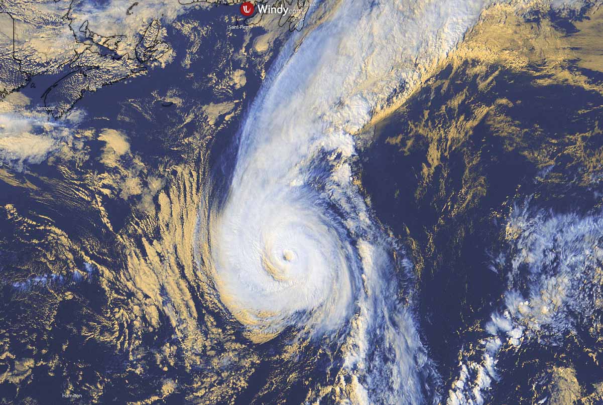
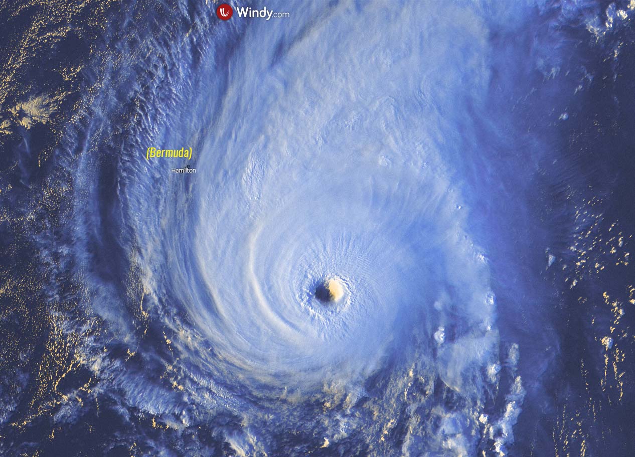
Sam had the flyby to Bermuda on Saturday and on Sunday, its structure is revealing it is still a solid hurricane. We can also see that to the north of hurricane Sam, there is a frontal system (boundary) that will take an effect on the system which will begin its gradual extratropical transition in about 36-48 hours from now (Sunday night).
The attached charts below are hinting the fluctuating intensity of Hurricane Sam, an effect of several Eyewall Replacement Cycles (EWRC). The tropical-storm-force winds are currently spread across the radii of 90-100 miles around the center of Sam, with hurricane-force winds up to 60 miles.

Although hurricane Sam is still a solid, high-end Category 2 storm, it is not expected to intensify any further but the gradual downtrend is forecast. However, it will remain over very warm oceanic waters for a few more days when the extratropical transition will be completed on Tuesday.
Above: A major Category 4 hurricane Sam on its gradual approach to Bermuda on Saturday
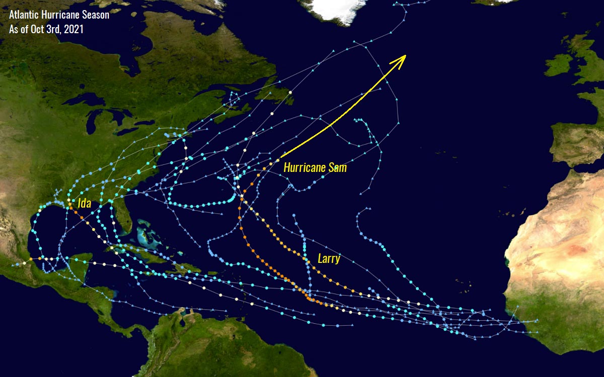
HURRICANE SAM GOES FOR EXTRATROPICAL TRANSITION SOON, TURNS TOWARDS ICELAND
After passing to the east of Bermuda island this past weekend, hurricane Sam is forecast to take a further northeast trajectory into the far North Atlantic. Sam is expected to slowly weaken as it moves over progressively cooler waters and begins the extratropical transition when it crosses the 26 °C isotherms.
The attached official National Hurricane Center (NHC) and GEFS ensemble model charts below are showing the future track of Sam across the North Atlantic as a powerful extratropical cyclone this week. The trajectories do have a clear hint that the system will be in a general movement towards Iceland and southeast Greenland by the end of the week.

Notice the right chart which indicated that the majority of the model forecasts keep the extratropical low’s central pressure even deeper than hurricane Sam is currently, meaning that the cyclone will remain a very intense North Atlantic storm.
The high-resolution models like the ICON model below, are simulating very intense winds are likely to re-develop again during and soon after the extratropical transition at the time, Sam will be a few hundred miles due east of Atlantic Canada and Newfoundland on Tuesday.

The wind-maximum chart above also hints that a so-called sting jet could also develop, a relatively localized jet of rapidly descending cold air inside a deep fully-developed extratropical cyclone. Read more about: What is a sting jet?
Below is the wide forecast for winds across the North Atlantic over the next 10 days, we can see how impressive wind swath Sam will produce. It keeps the swath pretty intense until the extratropical transition on Tuesday makes a spectacular loop and turns with an accelerating rate towards Iceland and Greenland afterward.

The extratropical low now is, however, forecast to track more north-northeast than towards east, so the impact on western Europe is unlikely. But the large swell of an intense extratropical low, despite traveling far away, could still affect Scotland, Ireland, and the Faroe Islands in the coming days.
Nevertheless, Sam and its remnants are the first tropical system that turned towards Europe this Atlantic Hurricane Season.
ATLANTIC HURRICANE SEASON IS SO INTENSE THAT IT SOON NEEDS THE SUPPLEMENTARY LIST OF STORM NAMES
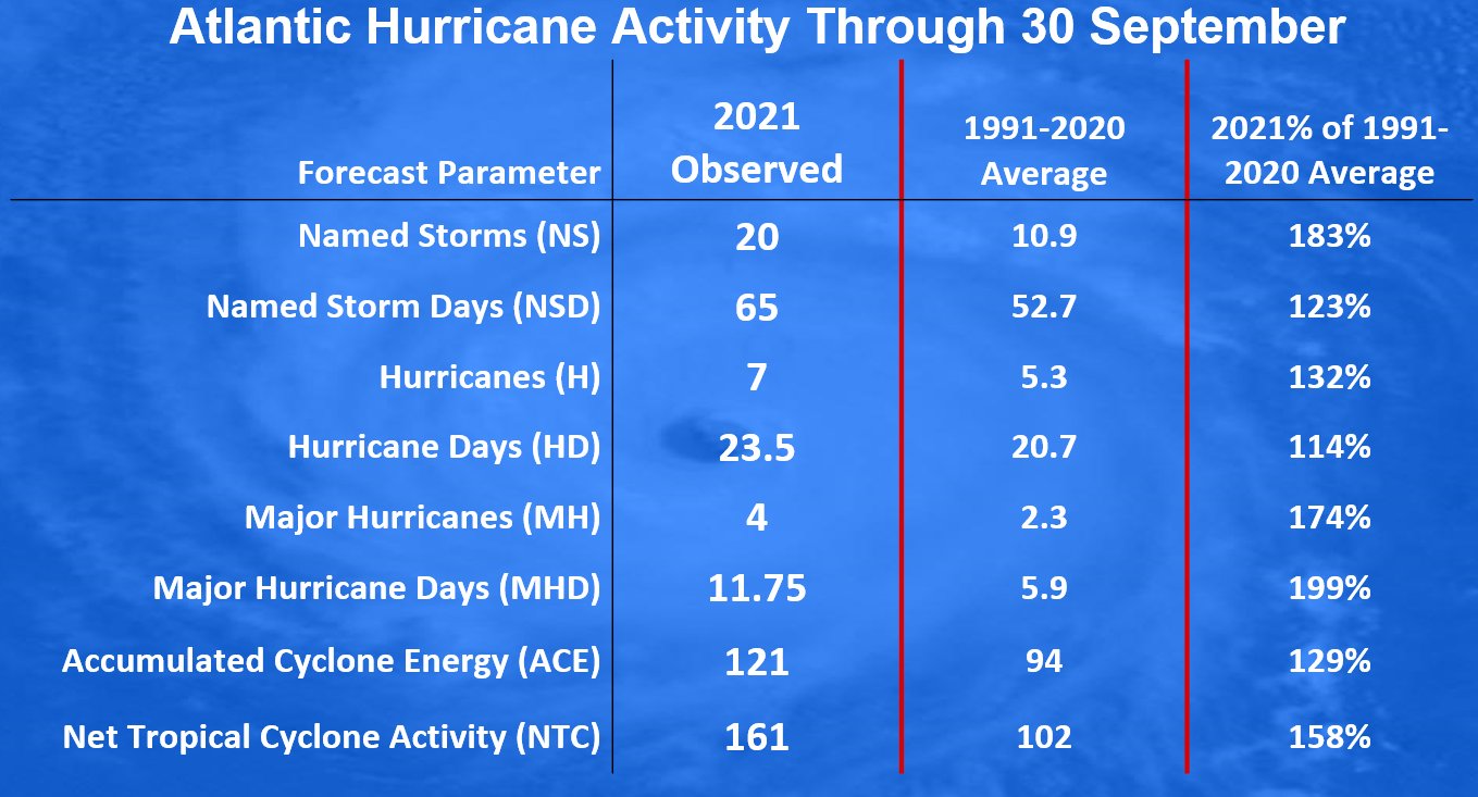
Hurricane Sam, followed by a short-lived tropical storm Teresa, and Tropical Storm Victor this week, are hinting that the Atlantic Hurricane Season is nowhere to its end yet. After the statistical long-term peak about a month ago, the hurricane season is running at more than 80 % of the average number of named cyclones in a typical year in the Atlantic. The only name left is Wanda.

According to dr. Philip Klotzbach, researcher at Colorado State University (CSU), there are normally about 10.9 named storms by Sept 30th. Those include 5.3 hurricanes, and 2.3 major hurricanes.
With 20 named systems so far, the tropical activity in the Atlantic is running well ahead of the schedule and it should remain above normal until the hurricane season is officially over by Nov 30th.
There have already been seven hurricanes and 4 major hurricanes besides Sam. Those were Grace, Larry, and Ida, setting the hurricane statistics also much above normal. Basically, all the parameters we usually track during the Atlantic Hurricane Season are *much* above normal.
According to the remarkable chart by Sam Lillo below, the trajectory increase of the Atlantic hurricane season tropical systems this year look pretty similar to the 2005 and 2020 surges in named storms. Remember that both of those hurricane seasons had the highest number of named tropical cyclones in history. The 2020 year had 30 storms, while 2005 had 28 named storms.
Now keep an eye on the long-term statistics from the above-normal years 2005 and 2020, can you imaging what could the Atlantic Hurricane Season 2021 bring until it is finally over? If we just take the number of tropical cyclone formations in 2005 and 2020, the potential is there we could easily see another 7-8 systems by Nov 30th. And that would put the 2021 hurricane season to around 28 named storms, or even more.
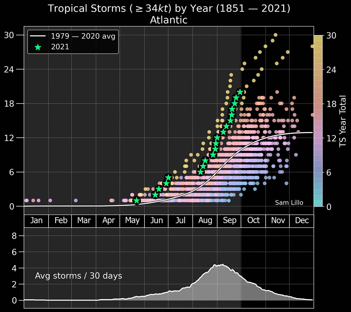
If we keep in mind how warm the Atlantic Ocean waters are and the major atmospheric MJO wave is emerging aloft, it is just a matter of time when the Atlantic Hurricane Season will graze into the uncharted territory. At least a few more tropical cyclones normally follow in October and November.
With only Wanda left from the official designated list by World Meteorological Organization (WMO), a supplementary list of tropical cyclone names will be needed this month. The names from this list are the following:

So when the official tropical cyclone names list is over, a supplementary list comes into use. This name list was predetermined by the WMO in spring this year, replacing the Greek Alphabet list that was in use for the most active years until now, 2005 and 2020. It brings much friendlier naming of the tropical systems, as using Greek alphabets made it quite difficult to track for many.
Recap: The hyperactive period of tropical activity in the Atlantic Basin has been incredibly long-lasting over the last 45 days and brought 7 hurricane formations between mid-August and the end of September this season. This is undoubtedly due to the extremely warm sea waters that are now coinciding with the incoming atmospheric MJO wave aloft.

This will lead to a combination of parameters that are expected to generate more dangerous tropical systems in the typical October secondary peak in the activity.
As we can see from the chart above, the tropical cyclone frequency in the average Atlantic Hurricane Season has two peaks. The seasonal highest activity during early September is the main peak, but October has an eye-catching secondary peak.
The secondary boost of the tropical activity during the month of October is quite often responsible for intense hurricanes that move across the Caribbean region and turn towards the U.S. mainland during the late Atlantic hurricane season period. Remember, in 2020 we had powerful and destructive hurricanes hurricanes Delta, Epsilon and hurricane Zeta, all occurring in October.
SAM GENERATED NEARLY HALF OF THE 2021 ATLANTIC HURRICANE SEASON ACE (ACCUMULATED CYCLONE ENERGY)
When we are monitoring how the Atlantic Hurricane Season is standing compared to the forecasts and previous years, we also use a special indicator that allows us to compare hurricane seasons with each other. A so-called ACE index is used for this matter, the Accumulated Cyclone Energy.
The ACE index is a technical metric that is used to express the energy that was used by a tropical cyclone during its lifetime anywhere in the world. ACE is an integrated metric accounting for storm intensity and duration of cyclones. The chart below hints at where the 2021 Atlantic Hurricane Season is standing.

During this year, the number of tropical storms and hurricanes has been increasing extremely fast since the beginning, and many of them were pretty intense. Just by the number of systems, this means we are really not far behind the record-breaking hurricane season of 2020. But that is why it is advised to use the ACE index to see how the season is actually standing.
Until October 3rd, the seasonal ACE index of around 125 has already been accumulated by all the 20 named tropical cyclones during the Atlantic Hurricane Season 2021. The highest ACE of the season was indeed generated by the ongoing major and long-lived hurricane Sam, which was already approaching 50 ACE this Sunday.
Above (satellite image): Major hurricane Larry was the 2nd highest contributor to ACE this season, ended up at 32.8 ACE during its 11 days of activity in the Atlantic Ocean. Both Sam and Larry alone produced more energy than the other strongest hurricanes this year together: Ida (10.8 ACE), Elsa (9.5 ACE), and Grace (9.1 ACE).
The highest ACE on record was generated by Hurricane Ivan (2004), 70.4 ACE. Followed by Hurricane Irma – 64.9 ACE, and 63.3 ACE by Hurricane Isabel. Since hurricane Sam is still forecast to remain an intense storm for another 48 hours, it will graze into the top-10 of all-time and very likely end up above 60 ACE throughout late this week.
Compared to the Atlantic Hurricane Season 2020, 2021 is not too far behind as the total generated ACE in 2020 was 185.8. That was quite well above the statistical threshold for the ‘extremely active’ ACE category, which is set at 152.5 for the Atlantic basin. With Sam to live and remain strong for a few more days, it will bring ACE much higher this week.

The chart above is showing the Atlantic hurricane season activity over the last 15 years, with ACE and the related number of hurricane formations in that particular year. The rising trend of ACE since 2016 is pretty obvious, with the highest ACE in this period found during the Atlantic hurricane season 2017.
If we are just looking at the number of tropical cyclone formations in one statistical Atlantic Hurricane Season, the only similar season to 2021 were 2020 and 2005. In 2005, the ACE ended up much higher than 2020, its final calculation was 250 ACE, with 28 tropical systems. Although the 2020 season produced 30 systems, their ACE was well apart.
The next update on Hurricane Sam is scheduled for Tuesday when the transition to an extratropical low will occur. Stay tuned.
If you don’t want to miss our future forecast updates, make sure to bookmark our website. If you found this article in the Google App (Discover) feed, feel free to hit the like button (♥) to subscribe for more of our in-depth discussions on various weather topics around the world.
** Images used in this article were provided by Windy, Weathernerds, and NOAA.