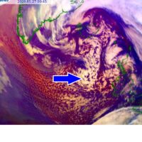
And we’re back at #weatherp0rn – Exceptional satellite imagery of the deep cyclone over the North Pacific
Like we discussed earlier today, the North Pacific cyclone is a real, photogenic monster. The satellite presentation is spectacular. Cyclone has reached 955 mbar this local early afternoon and...
A rapidly intensifying extra-tropical cyclone in the North Pacific today – heading towards S-SE Alaska with hurricane-force winds, major swell, and intense snowstorm
Conditions across the North Pacific are worsening as a very impressive frontal system is undergoing an explosive development, expanding its size with rapidly deepening central pressure. It had a...
The explosive development of an extra-tropical cyclone (~950 mbar) over the North Pacific on Tuesday, heading to a direct hit into Alaska through Wednesday
There is no break in the dynamic pattern even across the North Pacific, cyclones are forming over and over again. Yet another, this time a very intense cyclone, will...
Jan 26th update: A very large cyclone literally all over the North Atlantic now – developing widespread windstorm on its south, heading towards UK, Ireland and France by Tuesday
As we discussed yesterday, the current pattern over the North Atlantic and European continent is supporting blocking ridge over Europe but very deep trough across the North Atlantic. The...
Cold outbreak in the wake of a large North Atlantic cyclone delivers some colder weather and locally snow across UK and Ireland until Tuesday
The weather pattern across North Atlantic and Europe has not changed much since mid-December, there are constant deep and often violent extra-tropical cyclones developing. While the European continent is...
North Atlantic *update* – An exceptional satellite presentation of the monster cyclone in the North Atlantic, growing in size and deepening
Believe it or not, this is not a repost :) Indeed, it is yet another extra-tropical North Atlantic cyclone that has gone through a rapid intensification process. It has...
*UPDATE* – rapidly intensifying extra-tropical cyclone near Iceland tonight, pressure should drop 25-30 mbar through Saturday while the system grows much bigger
The primary discussion indicated North Atlantic is ready for another very intense extra-tropical cyclone, it has presented some very impressive satellite imagery since yesterday. The system has been steadily...
UPDATE: A remarkable satellite presentation of explosive cyclogenesis over the Northwest Atlantic today
As we discussed yesterday, yet another explosive development of the extra-tropical cyclone was expected today. An upper wave ejected from eastern Canada into the Northwest Atlantic and deepened, resulting...