Spring in Siberia has been unusually warm, and one of the warmest on record. Higher than normal temperatures have started to melt the permafrost layer, causing a diesel fuel tank to collapse and spill out over 20.000 tonnes of diesel oil into the Arctic environment.
WEATHER CONDITIONS
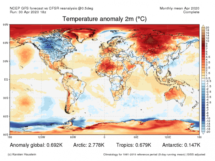
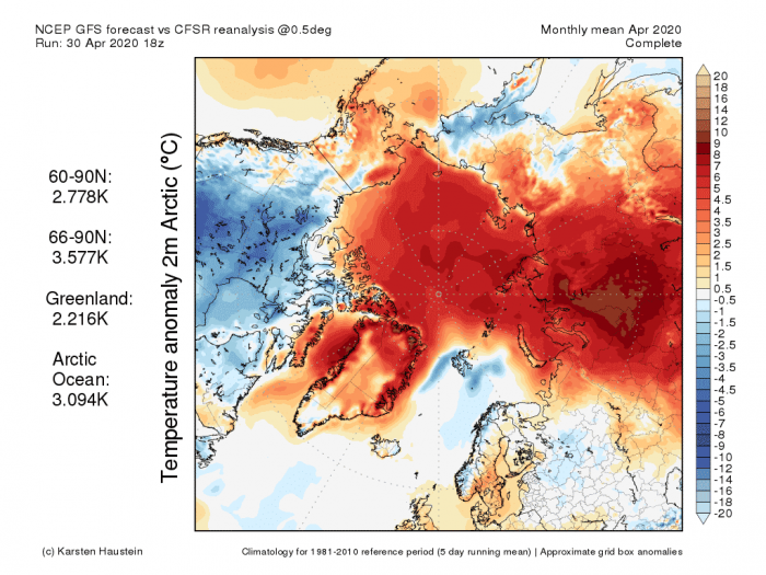
Weather in Siberia has been very mild during winter and also now in spring. The two images below show the temperature departure from normal during April 2020.
Siberia was the most abnormally warm area in the entire world. The average monthly temperature was up to 10°C warmer than normal in western Siberia, with daily departures going up to 20°C.
The Arctic ocean was also abnormally warm, experiencing frequent warming events. One strong Arctic warming event has raised the Arctic temperatures over 20°C above normal.
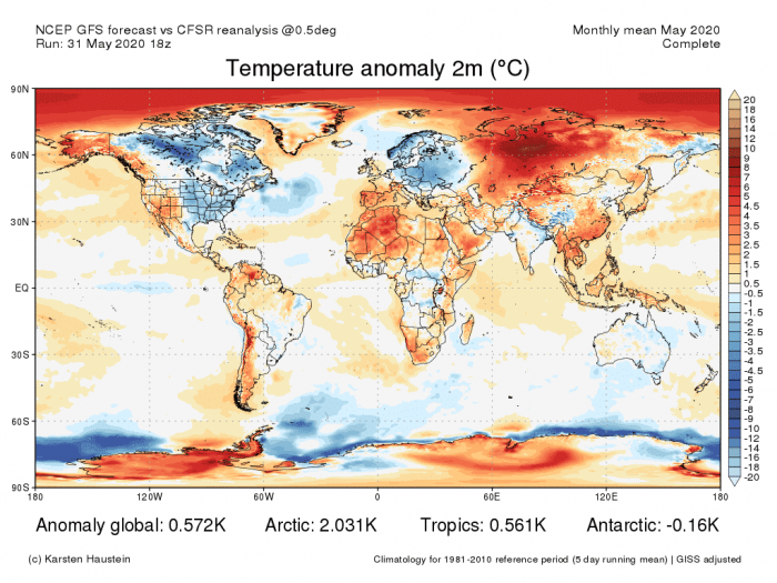
May 2020 was no better and has continued with the unusually warm weather for this time of year. Western Siberia was still the global “hotspot”. The Arctic Ocean has also experienced a strong warming event in May, as a powerful high-pressure system persisted over the pole for several days.
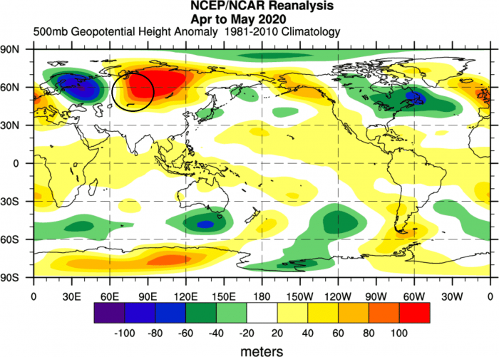
The west Siberian hotspot has developed because of a strong and persistent wave pattern over eastern Europe and Siberia. It consists of two pressure systems, high and low, which together act as a “pump”, transporting warmer air from the south towards the Arctic Circle.
The image below shows the April/May 2020 average geopotential height anomaly at 500mb level (~5km altitude). We can see the strong low-pressure system over eastern Europe and a strong high-pressure area over Siberia.
The strongest warm anomalies are usually found on the western side of the high-pressure system, marked with a black circle. There we can found a strong southerly transport flow.
PERMAFROST
Unusually warm weather is not without consequences, in an otherwise cooler region like Siberia. The ground layer inside the Arctic circle consists mainly of Permafrost, which is most negatively affected by the abnormally warm weather.
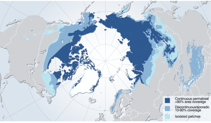
Permafrost is a permanently frozen layer of soil. It is found mostly in the Northern Hemisphere, where it covers about 25% of exposed land. This is generally an old layer and can be up to several thousand years old.
It covers a wide belt between the Arctic Circle and boreal forests, spanning Alaska, Canada, and Russia. It can vary in depth from a just few meters to hundreds of meters. The image below from the UN Environment programme outlines the main permafrost areas in the Northern Hemisphere.
THE NORILSK DISASTER…
Permafrost layer can be even harder than concrete and is a very good stable base for infrastructure. But persistent warmer weather can melt the layer, starting the thawing process.
The thawing process melts the ice inside the permafrost layer, leaving behind water and soil. The ground is no longer solid and is more like wet soil. This can destroy infrastructure that is built upon the previously solid frozen layer, as the ground becomes very unstable.
This is exactly what happened in the town of Norilsk in Siberia this week, which lies inside the Arctic Circle, on the edge of the Permafrost layer. The image below marks the location of the Norilsk town in Russia.
On May 29th, around 21,000 tonnes of diesel fuel spilled out from a collapsed reservoir in a local power plant. The fuel tank was built upon the solid permafrost layer. Ever-increasing temperatures, topped this year with the unusually warm spring, have started the thawing process in the permafrost.
The ground softened and became unstable, collapsing the fuel tank due to its sheer size and weight. Official reports have estimated that 6,000 tons spilled onto the ground while another 15,000 tons of oil spilled into the water. Oil products got into the Ambarnaya and Daldykan rivers and in almost all their tributaries.
https://twitter.com/GumisirizaM/status/1268616575642333184
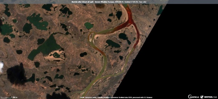
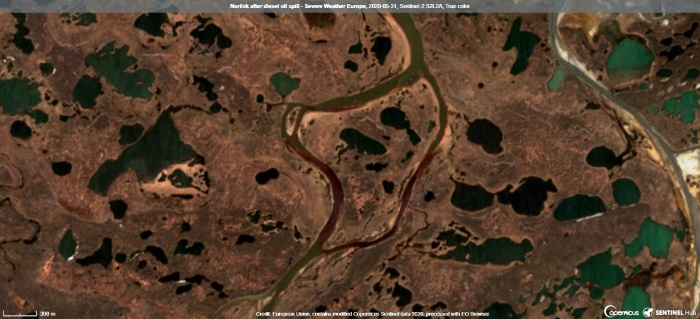
The extent of the spill was large, covering over 350 square kilometers. It was easily visible on the satellite imagery. Below are the Sentinel-2 images, which show the red diesel oil flowing down the rivers, on the first days after the spill.
State of emergency in Norilsk (Russia) after 20,000 tons of diesel leaks into Arctic river system pic.twitter.com/GSMqw6sl5a
— Rapusia (@SearchRapusia) June 4, 2020
We produced a video animation, which shows the satellite imagery sequence before and after the spill. The last image is from today (Sunday, June 7th), and we can still see the dark shading on the river, as the oil remains in the water.
An emergency situation has been declared by the state, as this is one of the largest oil spills in the Arctic circle. The initial damage is estimated at over 85 million $. A containment field was deployed on the river, to prevent the oil from flowing further north.
Based on the official reports, around 200 tons of fuel has been pumped out from the spill zone, and over 130 tons were removed from the Ambarnaya river alone. The total cleaning operation is estimated to last over a year and cost around 1.5 Billion $.
A satellite view at what rivers Ambarnaya and Daldykan outside Norilsk look now after the spill of more than 20,000 tonnes of diesel fuel pic.twitter.com/Wwpx2UqsLp
— The Siberian Times (@siberian_times) June 4, 2020
The Norilsk town is one of the country’s biggest industrial centers that lies above the Arctic circle. The company that owns the fuel reservoir is Norilsk Nickel, which is the world’s largest producer of palladium and Russia’s leading nickel mining and smelting company.
See more:
» Tropical storm Cristobal will bring a significant threat to the Gulf of Mexico coast this weekend «
