Summer 2020 is here, so its time to look at the latest forecasts to see what kind of weather we can expect. We will be taking a closer look at Europe and North America, but we will also take a broader look globally.
We decided to focus on the 3 main (or most used) seasonal models, the ECMWF and UKMO from Europe, and the CFSv2 from the United States. Graphics are from the Copernicus Climate EU project and the CPC/NCEP.
All these forecasts are an average picture over the course of 3 months (June-July-August) and show the general prevailing weather pattern. Even if the models would be completely accurate, it does not mean that such weather conditions would last for 3 months straight. It only shows/implies how the weather pattern might look 40-60% of the time.
GLOBAL CIRCULATION PATTERN
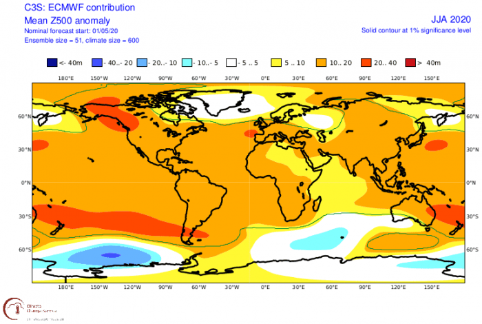
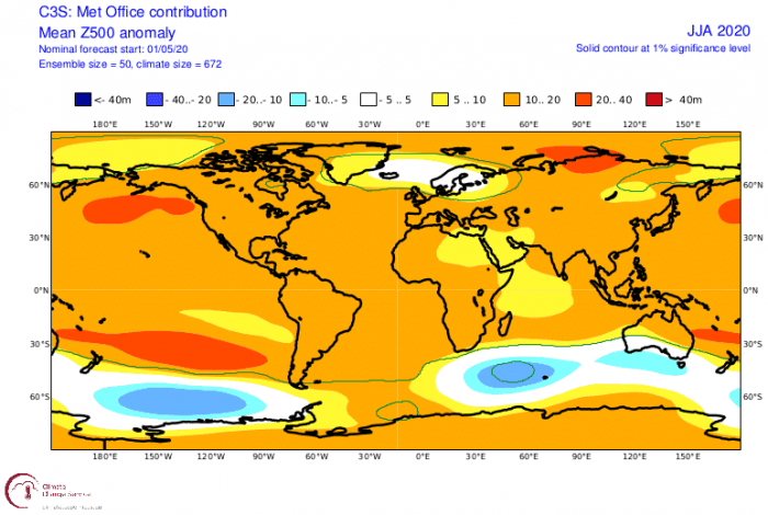
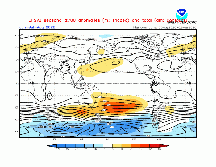
Looking first at the global 500mb geopotential height, all 3 models have a similar idea of a high-pressure area in the North Pacific. European ECMWF model also shows the high-pressure region centered over Alaska.
The Euro-Atlantic region, however, is quite different between the models. There, the European models go for a lower pressure area in the North Atlantic, keeping the North Atlantic Oscillation pattern similar to during winter.
The American CFSv2 model shows a weaker low-pressure area over the far North Atlantic. It also suggests a high-pressure region over the British Isles, extending into Scandinavia.
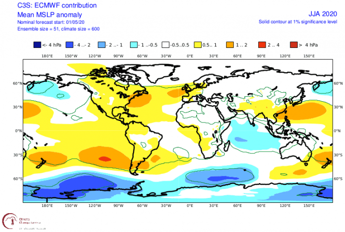
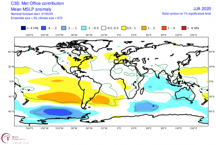
Surface pressure anomalies show that both European models agree on two high-pressure areas. One over Europe and one over the eastern parts of North America. We cannot show the surface pressure anomaly from the American model, as the graphics for this specific parameter are not provided.
EUROPE FORECAST
We now know that a pressure dipole is being forecast over the North Atlantic, similar to what we saw during winter. Of course, that suggests a similar-looking temperature and precipitation pattern.
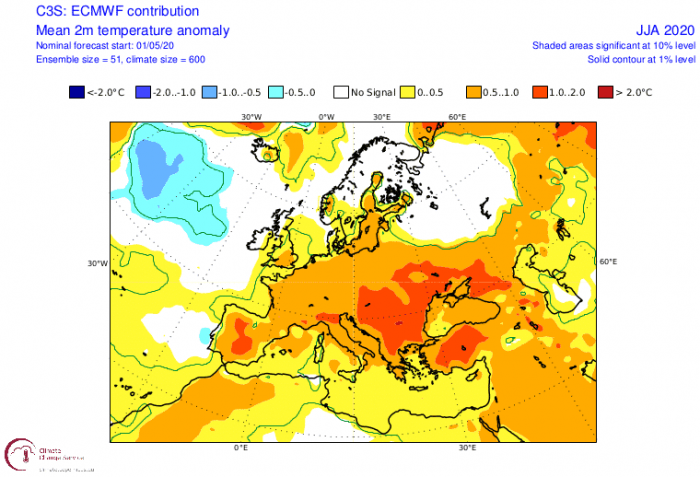
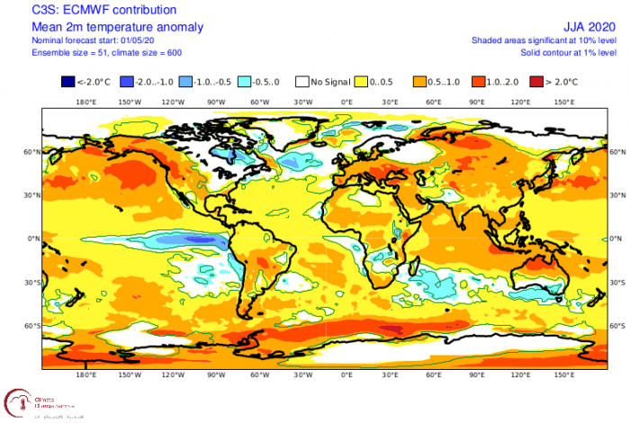
Just like during winter, we can see the cooler air is locked away further north most of the time, while warmer (hot) air mass dominates the mainland Europe. This would be a pretty bad scenario for mainland Europe. Especially given the general pattern which has the jet stream quite far north, providing less relief with low-pressure systems and/or cold fronts during the heatwaves.
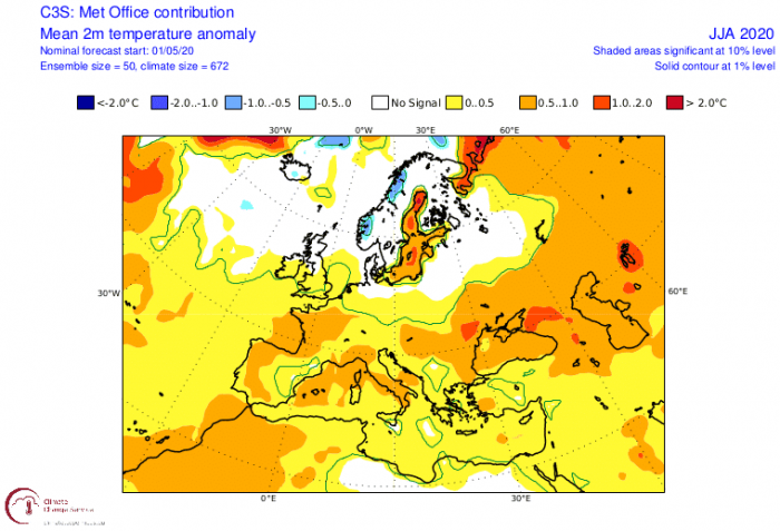
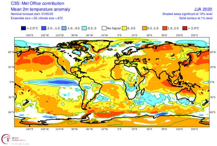
The Met-Office model (second image) has the jet stream a bit further south, along with the cooler air source. That results in shorter heatwave periods over central parts but pushes more of the warmer air further east/northeast. The British Isles and Scandinavica, are generally slightly warmer than average or around normal. That has a lot to do with the cooler than normal North Atlantic ocean, providing a milder than normal airmass.
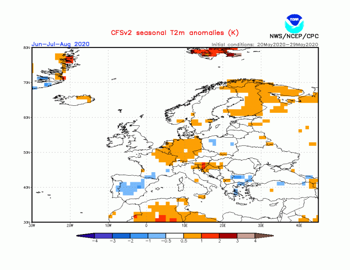
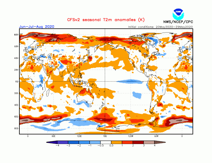
The American CFSv2 model (third image), tells a different story. Here the main bulk of the warmer/hot weather is over central Europe as well, but it shows colder than normal conditions over Western Europe and southeastern parts. Western Europe is shown as a cooler area due to the presence of a low-pressure area in this region and over the Mediterranean sea.
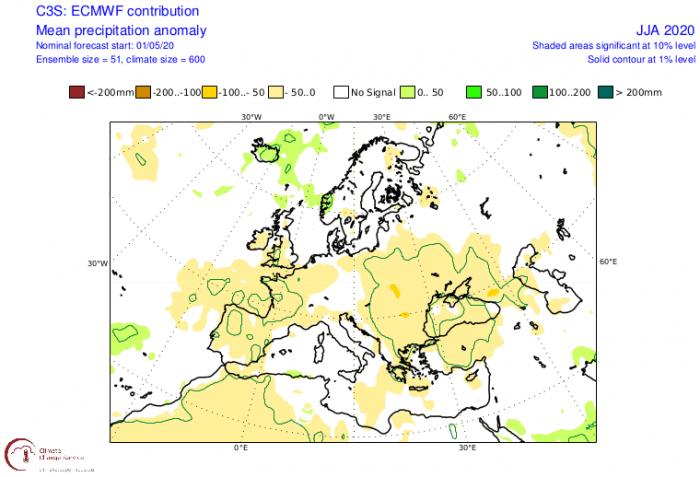
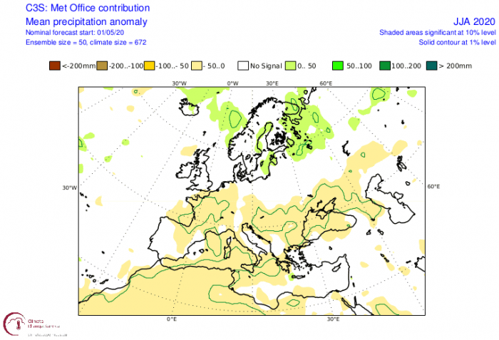
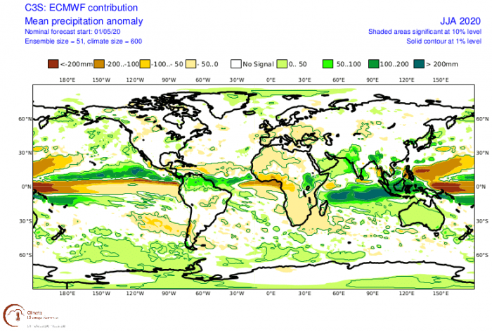
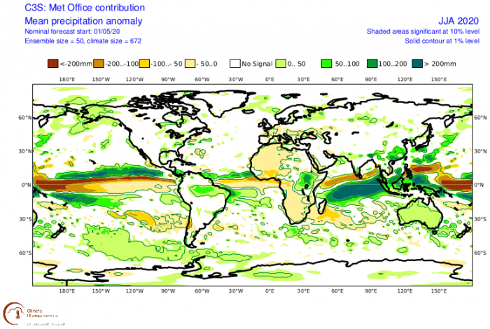
The Summer 2020 precipitation forecast is no surprise. Both European models show drier than normal conditions over mainland Europe. Northern regions have above-normal precipitation, as also suggested by the general circulation pattern and the jet stream position.
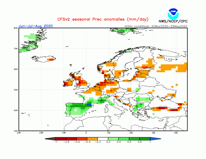
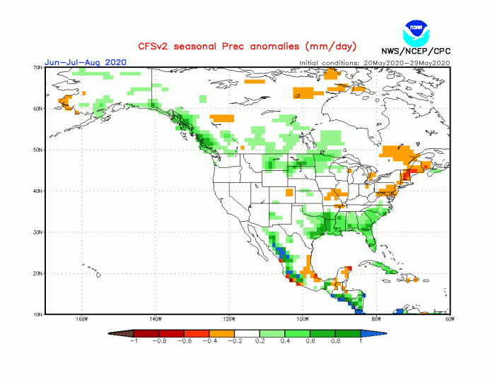
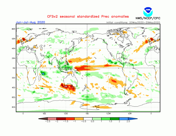
Yet again, the American CFSv2 model is somewhat different, as it shows above-normal precipitation over western Europe and parts of Central and southeastern Europe. This is a direct result of a low-pressure area over western Europe. Such a pattern would be dangerous for severe weather outbreaks over France, Germany, Alpine regions, and Northern Balkans.
NORTH AMERICA FORECAST
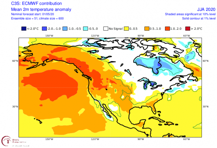
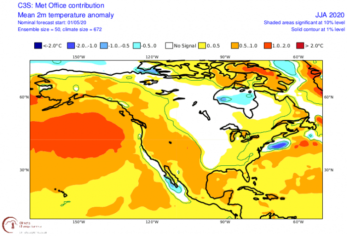
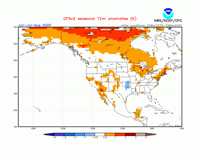
North America is quite larger than Europe, which means that it can have a much more diverse pattern. Obvious right away are the warmer than normal conditions over Alaska, western Canada, and the western United States. All three models tend to agree on that, with the American CFS model pushing the west coast warmth further north.
The Central United States and central Canada are forecast to have average to below-average temperatures during Summer 2020. This is a likely result of a low-pressure area in these central and eastern parts. But the pressure anomalies are likely not strong enough, so the low-pressure area gets hidden in the 3-month average picture.
Just like over Europe, an area which shows an average temperature forecast (neither warmer or cooler), can still have strong heatwaves. The average forecast just indicates that the number of heatwaves will be lower or that the heatwaves will be shorter. These are 3-month averages and a lot of dynamics can be hidden inside an average pattern
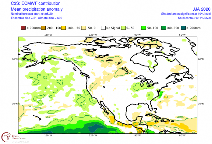
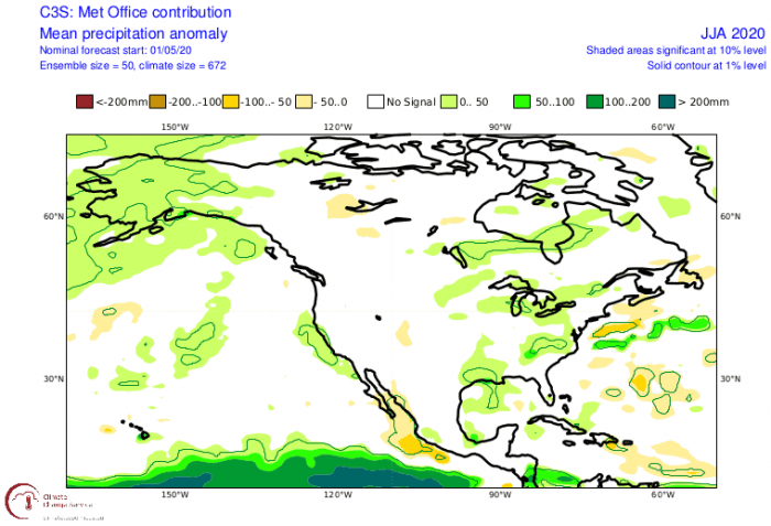
Along with lower pressure and cooler air, comes precipitation. And the models all indicate a wetter than normal summer over the central and eastern parts of the USA. And also over central/eastern Canada and Alaska.
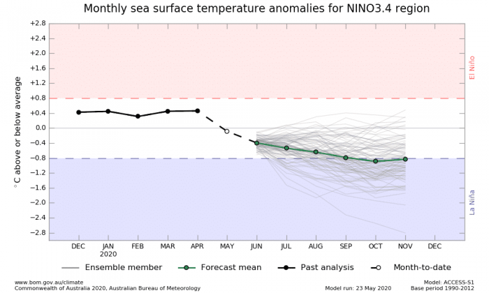
There is a big difference between the models in the Gulf of Mexico, indicating a very unpredictable tropical forecast. This has a lot to do with the development of a negative ENSO event, a La Nina. This will have to be monitored closely, as it is very important for the hurricane season.
REST OF THE WORLD
Looking at the rest of the world, we can immediately see the ongoing hotspot in Siberia. That region has had some of the highest temperature anomalies in the world so far this year. And the trend seems to continue during Summer 2020.
The southern hemisphere is entering its winter season. We can see a fairly good agreement between all the models, of a warmer than normal north Australia and cooler south Australia. The Australian pattern is also closely linked to the developing ENSO phase. But for now, no direct effects are expected during at least the June-July period.
Precipitation forecast is also quite similar across the southern hemisphere, and the tropics. All models develop a dry slot over the tropical Pacific, indicative of a developing negative ENSO phase, a La Nina.
We can see above-normal precipitation over Australia, which is quite a difference compared to last year. The precipitation pattern over Australia is also dependant on the state of the Indian Ocean Dipole (IOD) pattern. Last year we witnessed a record strong positive IOD in autumn. But this year a negative IOD phase will develop during the southern hemisphere Winter 2020.
As mentioned before, a lot depends on the development in the ENSO region in the tropical Pacific. Current forecasts show a transition into a negative phase, also called a La Nina. The image below shows the ENSO forecast from the Australian ACCESS–S model. Any influence of this developing negative phase is expected to appear during Summer, more likely towards the second half. Usually, it is not before Autumn that we can start to see global changes occur in the general circulation pattern from the ENSO development.
We will keep you updated on the development of the weather patterns during Summer 2020, as we keep a close eye on the ENSO region.
