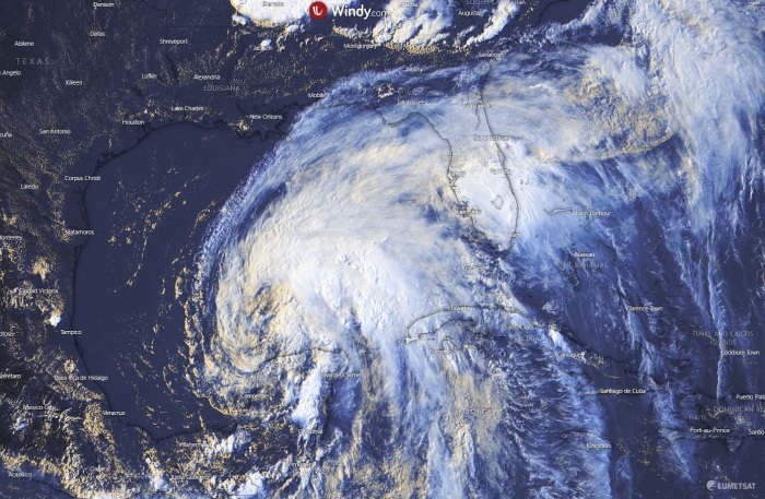
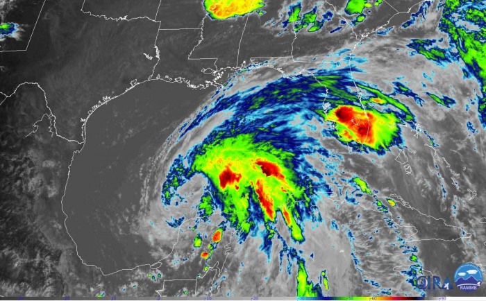
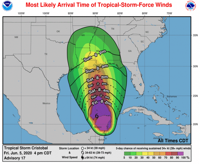
Tropical Storm Cristobal, the third named system of an already active hurricane season 2020, had maximum sustained winds of 35 knots / 40 mph on Friday afternoon, Jun 5th. Central pressure is 1000 mbar. The storm is expected to make landfall along the Louisiana coast this Sunday afternoon. Damaging winds, storm surge, torrential rainfall, and significant flooding are likely.
KEY FEATURES OF #CRISTOBAL
- Cristobal becomes a Tropical storm today and should maintain its intensity until the landfall over the Gulf Coast (Louisiana) on Sunday.
- Flooding and storm surge and rip currents will be the main issue along the Gulf Coast. Severe winds and tornadoes will be possible further inland with the system nearing landfall.
- The system is likely to remain very large and relatively slow-moving. Therefore its potential impact with excessive rainfall and flooding threat will be strongly enhanced, from Texas to the Florida coast. Significant flooding threat could develop across parts of Louisiana and Mississippi.
SATELLITE IMAGERY
The latest satellite imagery reveals the system is now strengthening, steadily organizing into a larger tropical storm. Cristobal has the most active storms across its eastern part, especially over the northeast quadrant. Mid-level dry intrusion is visible on its southwest side, this is also affecting its upper-level outflow ventilation. The storm will become more compact and strengthen tonight. Latest Advanced Dvorak estimates and NOAA Hurricane Hunters data confirm the Tropical Storm strength, with the northeast quadrant being the most dangerous part of the storm for now.
Tropical Storm #Cristobal is almost entirely over water now.
The main issue for it now remains dry air intrusion, which will keep convection held to the NE quadrant of the system and limit strengthening. If it fights this off, a more symmetrical structure is possible. pic.twitter.com/NksXb5OqNq
— Frank Carcaterra (@FrankCarcaterra) June 5, 2020
Large & asymmetric #Cristobal now officially a tropical storm again pic.twitter.com/wWMlSLUWmu
— Stu Ostro (@StuOstro) June 5, 2020
STORM WARNINGS FOR THE GULF COAST
As of this evening, a tropical storm and storm surge warnings have been issued for parts of the US Gulf Coast. From the delta of Mississippi River to the Ocean Springs Mississippi, including the Lake Borgne.
Note: A Tropical Storm Warning means the maximum sustained winds of 35-65 knots (40-75 mph) are expected in the next 36 hours. A storm surge warning means there is an increasing danger of life-threatening flooding by rising water moving inland from the coastline.
A tropical storm watch is in effect from Intracoastal City (Louisiana) to Morgan City. Additionally, a storm surge watch is in effect for Indian Pass to Aripeka, Florida, and from east of Morgan City to the mouth of the Mississippi River.
Note: A tropical storm watch means that tropical storm conditions, including severe winds and excessive rainfall, are possible within the watch area over the next 48 hours. A storm surge watch means there is a change of developing life-threatening flooding by rising water moving inland from the coastline over the next 48 hours.
Tropical Storm Cristobal will likely continue to move due north between two surface high-pressure systems. This should bring the system into the Gulf Coast on Sunday, making landfall on the coast of Louisiana in the afternoon. After the landfall, Cristobal will curve slightly towards the north-northwest, moving across the Mississippi valley early next week. Significant flooding threat and storm surge along the coastal areas is increasingly likely. Stay alert!
See the previous discussions:
- Tropical storm Cristobal forms in the Gulf of Mexico, it might turn towards New Orleans
- Remnants of Tropical Storm Amanda lead to destructive flooding in El Salvador – could re-develop as Cristobal into the Gulf of Mexico
Hurricane season 2020 could be very active – here is the prediction based on various forecasters:


