UKMO refers to the United Kingdom Meteorological Office, which is the official provider of public weather forecasts and warnings in UK. They are stationed in Exeter, United Kingdom.
The long range forecasting system from UKMO is called GloSea5, with the latest version having the official designation HadGEM3-GC2.0-v20190503.
All these forecasts are an average picture over 3 months (Dec-Jan-Feb), and show the general prevailing weather pattern. Even if the models would be completely accurate, it does not mean that such weather conditions would last for 3 months straight. There can still be cold fronts and snowfall in between such milder patterns in the mid-latitudes. The difference is that instead of the usual 10-20 snow days for example, you only get 3-6 snow days (as an example). So the models don’t suggest what the weather will be like for 3 months straight, but just how it might look 40-60% of the time.
Upper level forecasts.
We always want to know how the pressure forecasts look like. That tells us a lot about the overall global circulation and weather patterns. You can learn more about the importance of long range pressure forecasts in our previous post, that contains basic information that you need to know about long range forecasts, and graphics from the September model runs to compare:
Winter 2019/2020 early look (September) and LONG RANGE THEORY.
The 500mb geopotential height forecasts is similar to the ECMWF forecast. We see a deep low in the North Atlantic, surrounded by the “highs” from east USA across the Atlantic into Europe. This is probably the most classical positive NAO pattern that you can see on the long range forecasts. This is a typical pattern for windy and wet weather across the UK and Scandinavia, and mild conditions across central/southern Europe. In the USA, we have warmer and drier conditions in the east, and mild and more wet in central/southern parts. We see a hint at trough development over Midwest, and a blocking high in North Pacific, similar to the ECMWF.
Staying at altitude, we have the 850mb temperature forecast, which is on average around 1.500 m altitude in the mid-latitudes. Here, we can see what we expected from the 500mb height forecast. Warm conditions across Europe and east USA. We see the lowest “above normal” category (0-0.5) in the west, due to the likelihood of more northerly flow on average there, and occasional cold fronts from the north.
Surface levels
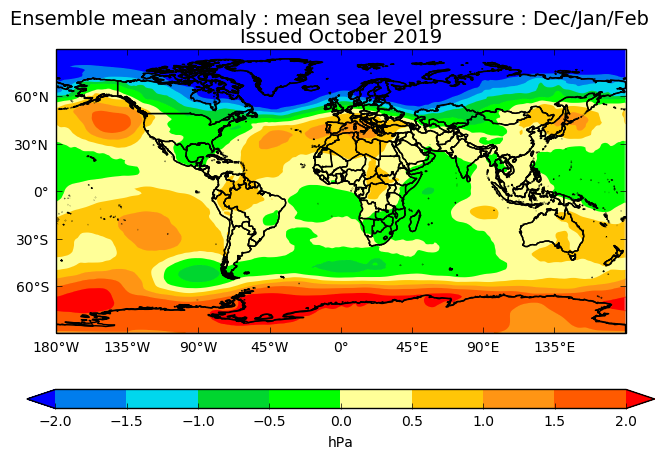
Going down to the surface, we start with pressure again. This shows the pressure anomalies at the surface, which are more influential for surface wind conditions and temperature transports. Here we see the entire North Pole is under low pressure (positive AO – Arctic Oscillation), which means the coldest air is locked inside the Arctic circle, and is harder for it to move towards south into Europe for example. That is a typical sign of a strong polar vortex. For Europe, we see a broad low pressure area in the North Atlantic, which promotes west air flow across the UK and west/northwest over Scandinavia, just as expected from the general circulation forecast above. This means stormy weather for UK and Scandinavia, with less chance for easterly conditions and thus less chances for colder weather in the UK.
In the USA, we can see a low pressure extension over eastern half, which drives the warmer westerly/southerly flow on its south and east side. But at the same time it promotes more northerly (and potentially colder) flow across the western parts together with a strong high pressure zone in the north Pacific.
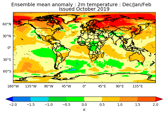
One of the most used long range parameters is of course the 2-meter temperature anomaly forecast, also simply referred to as the surface temperature forecast. It is the main forecast to tell us what to expect in terms of temperatures (warmer/colder). As we have interpreted already from the charts above, there are no surprises here. Warmer than average across Europe and east USA, with hints of possible colder air in the western parts of USA. We can see that large part of the polar circle is in above average temperatures, just like the ECMWF forecast, which is perhaps a bit questionable to this extent, but not impossible with the low pressure across the entire region and west flow on its outer perimeter.
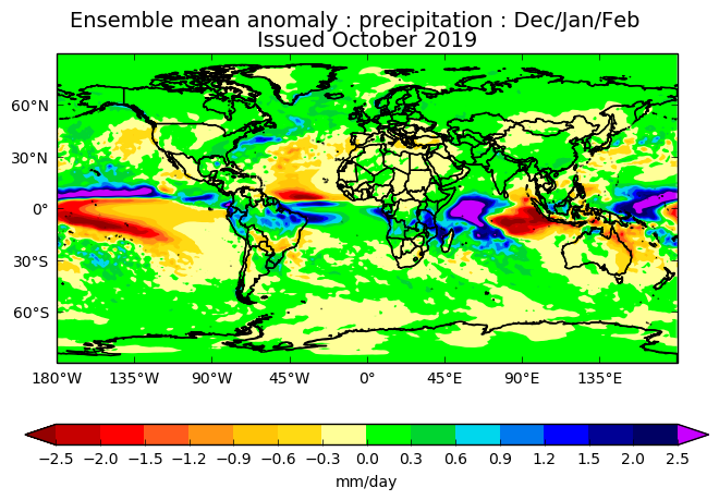
Looking at precipitation forecast, we also see a typical positive NAO signature. Wetter than normal over UK and northern Europe, and drier than normal across southwest and southern Europe. Over USA we see wetter conditions over southeast/east parts, as a result of the low pressure over central parts.
To summarize, the UKMO forecast from October, shows a typical positive NAO pattern, with milder winter in Europe and east USA, while more winter conditions are occasionally expected across western USA.
We still have the stratosphere as a major factor. Long range forecasts are generally not as good at forecasting stratospheric dynamics in detail, which means they tend to underestimate any potential sudden stratospheric warming events (SSW’s), since the final forecast is made out of many individual calculations, which have different ideas about the stratospheric development. An SSW event can have a major impact on the circulation and can cause major pattern changes in the Northern Hemisphere. So a potential SSW event is an important factor that can change the course of winter in either way across the North Hemisphere.
There are more long range models waiting to be explored, so click below to go back to the model selection page:


