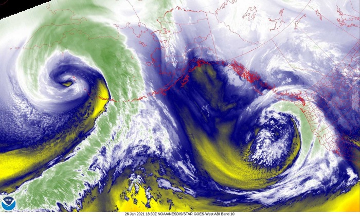
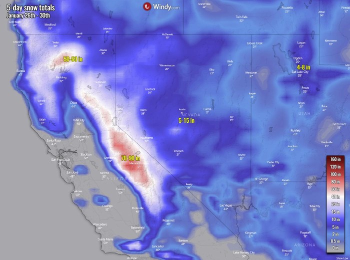
There are now two dangerous storms over the Pacific, one grazing into the Aleutian Islands, Alaska, and another deep low pushing a winter storm into the West Coast. Massive 5 feet of snow is forecast for the Sierra Nevada mountains, California. The system over the Aleutians has rapidly intensified into a monster 940 mbar storm. Producing hurricane-force winds and destructive waves.
Once again, the North Pacific is showing no rest as winter outbreaks from the Arctic Siberia has been generating storm by storm this season over the seas. This has lead to a much above-average number of mid-latitude cyclones this year. It has also brought record-breaking rains along the Northwest Pacific of the United States.
Almost every storm went through explosive intensification and reached a violent strength while moving towards the Aleutian Islands and Alaska mainland. For instance, the final day of the 2020 year has even produced most intense storm on record for the North Pacific and Alaska. No wonder season is so extreme this year.
There are now two large storms over this part of the Earth, the extratropical system over the Aleutian Islands, Alaska being the most intense. It has deepened to lower than 940 mbar, now near its peak intensity right at the time of crossing the Aleutians near the westernmost part of Alaska – Attu Island.
The system to the right of it is a deep wave emerging into the West Coast of the United States, expected to deliver huge amounts of rain for parts of California and especially an extreme, near 5-foot snow for the Sierra Nevada Mountains.
Both storms have revealed an impressive appearance on the satellite imagery. Attached below are various channels by NOAA GOES-16.
Typically, an extratropical low forms outside of tropical regions, despite the phase tropical in its name. These systems form when very cold air masses in the upper-levels interact with warm air masses over the sea (e.g., Pacific or Atlantic). As these bodies of cold air collide with warm air bodies, it leads to weather fronts formation.
As these fronts mature and strengthen, the denser, drier cold air masses move underneath the more buoyant warm air masses and help force the warm air to rise. With this rising air leaving the surface, a low-pressure system forms into a (rapidly) deepening storm. In the northern hemisphere, the winds of these cyclonic systems deflect to the right as a result of the Coriolis Effect.
The further process of warm air rising in the atmosphere starts cooling it and therefore releases its potential energy. The air becomes more buoyant and consequently fuels the storm’s core with even stronger upward movement of air. At the final stage, this further lowers the pressure at the surface, intensifying the storm. The most intense storms become a so-called bomb cyclone with explosive strengthening of the wind field and rapidly deepening central pressure.
NEW STORM FOR ALEUTIAN ISLANDS
An impressive large frontal system has emerged Monday this week and gas underwent a rapid intensification overnight Tuesday, becoming yet another monster North Pacific storm. The attached airmass NOAA satellite scan below reveals a remarkable intrusion of Arctic air mass across a broad wake of the system. The system also reveals an impressive satellite presentation with a large comma cloud moving over the Aleutians. A textbook dry conveyor belt is being wrapped into the core and started a bombogenesis process.
By the official definition, a rapidly deepening low with at least a 24 mbar pressure drop in the past 24 hours period is classified as a bomb cyclone. This rapidly strengthening process of the extratropical storm is called bombogenesis.
According to the weather models and recent satellite data, a very intense bombogenesis has started through Monday night, with a rapidly deepening central pressure of the storm. The central pressure has dropped for almost 50 mbar over the past 36 hours. Thanks to the advection of very cold Arctic air mass into the Northwest Pacific, a new storm has literally exploded into a powerful system last night. Steering flow drags it across the Aleutians this Tuesday.
Below are the estimated mean sea-level pressure analysis data, provided by the NOAA Ocean Prediction Center (OPC):
- 940 mbar at 12 UTC, Jan 26th
- 965 mbar at 00 UTC, Jan 26th
- 976 mbar at 12 UTC, Jan 25th
- 988 mbar at 00 UTC, Jan 25th
- 996 mbar at 12 UTC, Jan 24th
- 1002 mbar at 00 UTC, Jan 24th
Based on the pressure readings from the chart above, the central pressure has had a remarkable 36 mbar pressure fall over the last 24-hour period, between Monday 12 UTC and Tuesday 12 UTC timeframes. With the most rapid strengthening over the final 12 hours period as the pressure fall was 25 mbar, so more than a double of the official bomb cyclone threshold criteria. The mature stage should soon be reached and might drop for a few more millibars while emerging into the Bering Sea.
ALASKA SEES NO REST
The last major (winter) storm that hit Alaska was less than 14 days ago and brought widespread heavy snow and blizzard conditions for southern parts of the state. Alaska has been experiencing system by system over the past weeks, the chain of volcanic islands – the Aleutian Islands – has seen an even more intense mid-latitude cyclone season this winter.
This is yet another violent system for the archipelago, grazing across the westernmost islands this Tuesday. It is not as intense as the storm on the satellite image below, but its intense core is still resulting in destructive waves and hurricane-force winds over the area.
Note: This storm above has had an outstanding 75 mbar pressure fall over the 36-hour period (from 996 mbar to 921 mbar) between Dec 30th 00 UTC and Dec 31st 12 UTC. And has set a new record for both Alaska (Aleutians) and the North Pacific territory and become the most intense storm since observations have begun.
The storm’s track was generally north-northeast through Monday night into this morning while the pressure was dropped to 940 mbar as 12 UTC today (local morning). The system has grown very large and become extremely intense.
The peak intensity is, unfortunately, ongoing right at the time when the center of the low is moving across the small islands of Adak, Kiska, and Attu with immediate life-threatening power of the hurricane-force winds. These winds are the most violent a few hundred miles south, generally with gusts of 100-120 mph.
DESTRUCTIVE HURRICANE AND STORM FORCE WINDS
The northern swath of these violent winds are grazing across the islands through this Tuesday morning and will continue into mid-afternoon hours. Peak gusts could reach near 80-100 mph just off to the south of the Pacific side of the coasts. Winds will also increase across the southern Bering Sea as the storm will grow very large and emerge further north tonight.
These violent winds are typically produced by a so-called sting jet wind maximum. There are no other phenomena with the mid-latitude cyclones that would be able to generate such winds. This could happen with storms having even higher central pressure than 960 mbar but it tends to be extremely violent as pressure goes lower and the gradient around the core strengthens.
A sting jet phenomenon is a narrow zone of strong winds, originating from within the mid-tropospheric cloud head of a rapidly strengthening cyclone. Winds are enhanced further as the jet descends, drying out and evaporating a clear path through the precipitation.
The evaporative cooling leads to the air within the jet becoming much denser, causing the acceleration of the downward flow towards the tip of the cloud head when it wraps around the cyclone’s center. Windspeeds in excess of 100 mph (160 km/h) are often associated with the sting jet. The shape of the cloud, hooked like a scorpion’s tail, gives the wind region its name – a sting jet.
When explosive strengthening and deepening of the central pressure occurs, sting jet winds always generate major waves with significant heights. The weather models were simulating this scenario of extreme wave heights for the islands, potentially even more than 55 feet (17 meters) with this storm!
A HURRICANE FORCE WIND WARNING remains in effect for the Aleutian Islands (Adak to Kiska) up to 100 nm out on Tuesday. Violent winds and destructive waves are expected. The Bering side, seas up to 24 feet, building to 30 feet in the afternoon. The southern side, seas 28 feet building to 48 feet in the afternoon. Widespread snow showers of rain and snow are expected.
Another HURRICANE FORCE WIND WARNING remains in effect for the Aleutian Islands (Kiska to Attu) up to 100 nm out on Tuesday. Violent winds and destructive waves are expected. The Bering side of the Aleutians, seas 27 feet building to 42 feet in the afternoon. The southern side, seas 35 feet building to 54 feet in the afternoon.
WINTER STORMS HEADS FOR THE WEST COAST
Another deep extratropical low over the North Pacific is emerging into the West Coast of the United States today. It will spread a dangerous winter storm into California with a huge amount of rain and extreme, several feet deep snowpack for the Sierra Nevada Mountains. Weather models hint at near 8-12 inches of rain on the western coasts. With 70-90 inches (5-6 feet) of snow over the next 5 days for the Sierra.
FLOODING and WINTER STORM WARNINGS have been issued for numerous locations.
***The images used in this article were provided by Windy and NOAA.


