The Polar Vortex is without a doubt one of the key rulers of the winter weather. This winter, the Polar Vortex has collapsed, losing a lot of its influence over the Northern Hemisphere. It is now trying to reorganize and influence our weather again. But as you will see, the coming weather dynamics in February will perhaps be too much for the Polar Vortex to handle.
Life of the Polar Vortex is like a good story. A story of a king, on its frozen throne over the North, ruling over our weather. But no king rules forever, and this Winter we have seen significant consequences as the Polar Vortex has collapsed.
Before explaining what is coming for the Polar Vortex and our weather, we will quickly learn what exactly is the Polar Vortex. We try to explain this in most of our winter articles, as knowledge is essential and powerful, so why not learn something new in just mere seconds.
WEATHER KING OF THE NORTH
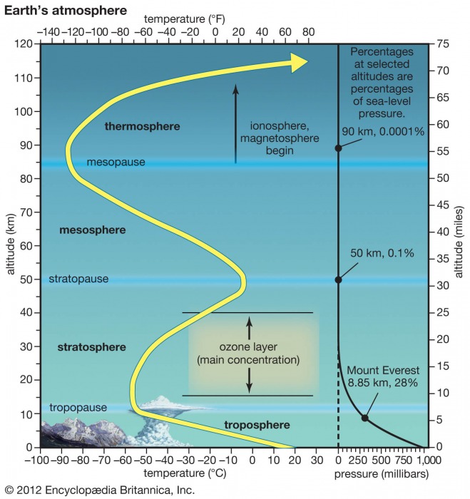
All of the clouds (and the weather that we feel) are found in the lowest layer of the atmosphere called the troposphere. It reaches up to around 8 km (5 miles) altitude over the polar regions and up to around 14-16 km (9-10 miles) over the tropics.
Above it, there is a much deeper layer called the stratosphere. This layer is around 30 km thick and is very dry. This is where the famous Ozone layer can be found. You can see the layers of the atmosphere on the image below, with the troposphere on the bottom and the Stratosphere with the ozone layer above it.
These layers are important, because when you hear people talk about the polar vortex and its influence, 95-99% of the time they mean the higher altitude stratospheric part. While the stratospheric polar vortex is spinning high above our weather (but being strongly connected and influental), the lower tropospheric polar vortex actually IS our weather.
Every year as we head into autumn, the north pole starts to cool down. But the atmosphere further south is still relatively warm as it continues to receive energy from the Sun, while the polar regions receive much less over time.
As the temperature drops over the polar regions, so does the pressure. In the stratosphere, the process is the same. As the temperature drops over the pole and the temperature difference towards the south increases, a large low-pressure (cyclonic) area starts to develop across the polar stratosphere.
The image below shows a typical example of the Polar Vortex at around 46km altitude (1mb level) near the top of the stratosphere.
It is essentially like a very large cyclone, covering the whole north pole, down to the mid-latitudes. It is strongly present at all levels, from the ground up, but in different shapes.
The next image below will show you the temperature forecast at around 5km altitude, revealing the true shape and size of the polar vortex closer to the ground (cold colors). The closer to the ground we get, the more deformed it gets, due to the growing influence of the terrain and the many weather fronts and systems.
You can see on the image below what the true extent of the polar vortex looks like at lower altitudes. Be aware of its “arms” extending into eastern and western United States, also bringing along colder air into the region in early February, which is the time of the forecast on the image.
For an even better idea, we produced a high-resolution video for you below, which very nicely shows the Polar Vortex spinning over the Northern Hemisphere at around 5km altitude. In the video, you can see the temperature forecast at this altitude, as the temperature is a very good tool to see the actual size and shape of the complex structure of the Polar Vortex this low down.
The main takeaway from the video should be that the Polar Vortex is not just one single winter storm that moves from the Midwest to the northeastern United States. It is one large cyclonic area that is spinning over the entire Northern Hemisphere, from the ground up to the top of the stratosphere at near 50km altitude.
POLAR VORTEX COLLAPSE
Usually, we look at the polar vortex in the stratosphere at the 10mb level. That is around 28-32km (17-20 miles) altitude. This altitude is considered to be in the middle stratosphere and serves as a good representation of the general dynamics of the polar vortex.
The strength of the polar vortex is most often measured by the power of the winds inside it. Usually, this is done is by measuring the zonal (west to east moving) wind speeds around the polar circle (60°N latitude).
Below we have an analysis from the NASA monitoring system, where you can see a very interesting progression.
In early December, the polar vortex was at a strong level, reaching over 40m/s (90mph) zonal wind speeds. Towards mid-month, and especially towards late December, the polar vortex began to weaken. We can see the zonal wind became negative in early January, due to the breakdown of the polar vortex.
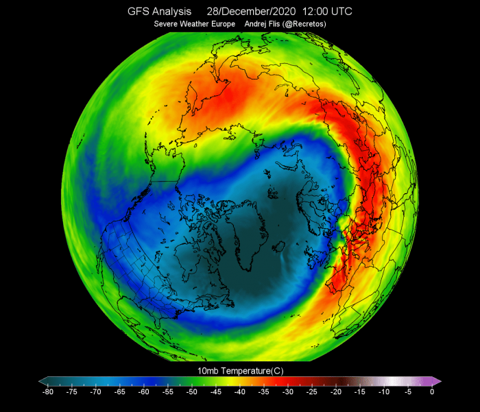
The next images below will show you the temperature at the 10mb level, which is in the middle stratosphere at around 30km altitude. Here, the polar vortex is much more uniform in shape as there is less influence from the terrain and the weather fronts at this high altitude.
To continue our story… In late December, a warming sequence began in the stratosphere, from Europe over into central Asia. It was starting to engulf the outside layers of the polar vortex. The cold-core of the polar vortex was still rather intact at this point, holding temperatures colder than -80°C in the center over Greenland.
Just two days later, the warming wave reached a local peak over Siberia, with maximum temperatures in the wave reaching up to +5°C or higher. In normal conditions, the temperatures here are over 30-40°C lower, so this was a significant warming wave.
At this time, the actual polar vortex at this altitude (30km) looked more triangular in shape. The image below shows vorticity, or to simplify, the energy of the polar vortex. We can see it was being drained of energy, by a strong (barely visible) anticyclonic system over the North Pacific and the Aleutians. The ultimate nemesis of the Polar Vortex.
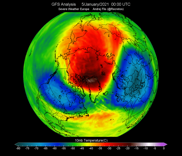
On January 5th, the preliminary date of the Sudden Stratospheric Warming event was marked, as the winds around the polar circle have reversed.
The stratospheric warming wave has crawled over the entire North Pole in the stratosphere, effectively splitting the cold-core of the polar vortex into two parts.
One part of the broken polar vortex has moved over North America and one over the European sector. At this point, this does not have much to do directly with the winter weather on the surface, as this is at 30km altitude. But as you will see, our weather gets its share from this battle.
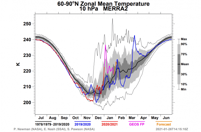
Taking a look at the NASA temperature analysis for the polar stratosphere, we can see the large temperature spike at the 10mb (30km) level. This shows a strong warming event, with temperatures continuing to stay above normal to this day.
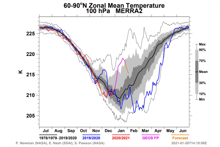
Even lower is the 100mb level (15-16km altitude), which is somewhat of a boundary or the “buffer zone” between the stratosphere and the troposphere. Here we can also see the temperature spike, meaning the warming event was fairly robust and fast and reached down to the lower levels, bordering the weather itself.
When trying to find a connection between the stratosphere and our winter weather, it helps to have more specialized images at hand. Especially one that shows altitude and time.
The image below shows an atmospheric pressure index. Negative values indicate higher pressure and positive values indicate lower pressure. We have altitude from the ground up to the top of the stratosphere (~46km) and over time.
You can see strong negative values in the stratosphere in early January, associated with the higher pressure buildup during the stratospheric warming event. We can see that this event and/or its influence was slowly descending over time, reaching the lower levels by mid and late January.
Looking at the same image but for temperature anomalies, the strong stratospheric warming is very obvious. Also nicely seen is the downward movement of this warming event. The only difference to the previous image is the vertical scale, as this graphic only shows the altitude from 11km to 46km. You can see that the temperature wave from this warming has touched down to the top of the troposphere, at the border of our weather.
POLAR VORTEX AND WINTER WEATHER
By now, you know what the polar vortex is and how its collapse has touched down on the roof of our weather. But to see the connection further down, we need a new type of imagery.
The best way to see this connection is to look at the altitude again. But instead of looking over time, you will now be looking over the entire world from west to east (longitude).
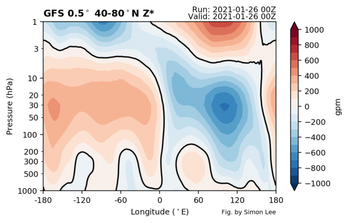
The great image below is produced by Simon Lee and shows pressure (height) anomalies for the northern hemisphere across the world on January 26th. You can see higher pressure connecting the stratosphere down to the lower levels around -180 longitude, which is around the Northern Pacific. Another high-pressure extension is around -60 to -120 longitude which is in Greenland to North Canada sector.
If you look at the height (pressure) anomalies for today, January 26th, we can actually see the exact same high-pressure systems in those regions. A strong high-pressure system in North Pacific and an even stronger one over northern Canada, extending into the North Pole.
This building of high pressure around and into the polar regions greatly disrupts the polar and subpolar circulation. It allows the release of colder air out of the polar regions towards the south, into Europe and the United States.
The key takeaway here is that under strong polar vortex conditions, such breakdown of the polar vortex circulation is very hard or less likely. Strong polar circulation can trap the colder air into the polar regions, causing quite warmer than normal winter across Europe and also most of the United States. So if you like cold and snowy winter, your chances of success are better with a weak or disrupted polar vortex.
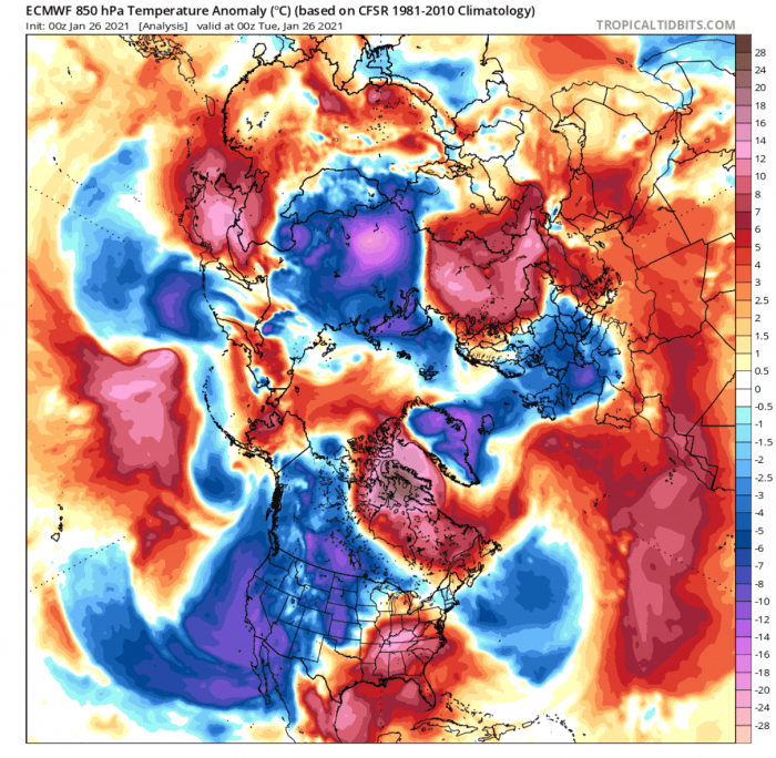
The temperature analysis for January 26th shows just that, as we can see a large mass of colder than normal air moving down into the western and central United States. Over Europe, we also have cold anomalies, as a cold front has swept across the central and eastern regions. This is due to the broken polar circulation, by the dominant high-pressure systems.
At this time, the stratospheric polar vortex at 30km altitude (10mb level) is entirely pushed aside, over the Siberian sector. This greatly limits its weather influence potential over the entire Northern Hemisphere. The image is again by Simon Lee.
As mentioned before, we usually look at the speed of the stratospheric zonal (west to east) winds to estimate the strength of the polar vortex. The forecast below shows the current values at 15m/s which is fairly low. But as you can see, another weakening is coming in early February, almost reversing the zonal wind component in the stratosphere.
Looking at early February, you can see how a strong high-pressure system has built over the Aleutians again in the stratosphere. It will push/pull the polar vortex out of Siberia and over Greenland and Scandinavia.
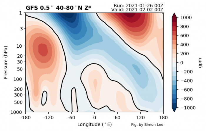
Going back to the vertical image for the same period, you can snow see the high pressure in the Stratosphere being stronger. This is the high-pressure area that is pressing against the Polar Vortex. We can see its “legs” connected to the lower levels between -60 and -170 latitude, from west Greenland into the Aleutians and Siberia.
The low-pressure (negative) anomalies you see above from the polar vortex, are very tilted, indicating weak organization and limiting its direct influence.
The actual pressure (height) anomalies for that period show the persistent high pressure blocking over northeastern Canada and over Siberia, connecting to the North Pacific. These are the two “legs” that connect up into the stratosphere. You can also see low-pressure areas over Europe and western and eastern United States.
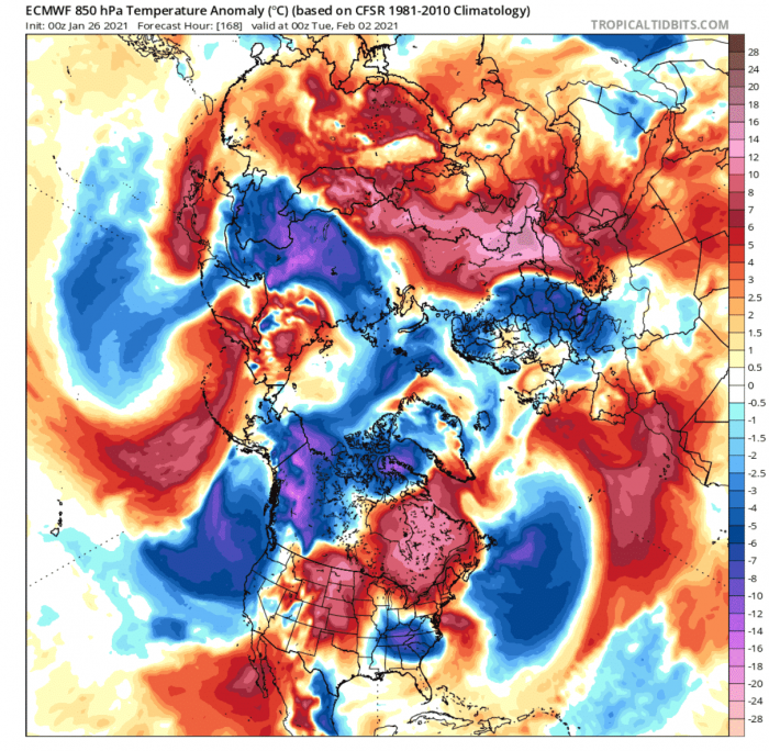
Temperature anomaly reveals colder air for parts of eastern United States as a storm is transitioning, and also for the west coast, under the low-pressure system. In Europe, another cold front sweeps across central and eastern Europe.
Going few days ahead, the polar vortex will play by the rules of the high-pressure system over the Aleutians. The forecast is not clear at this time, but some ideas also show at potential polar vortex split into two cores, which could mean a huge blow for the polar vortex ever reorganizing back fully.
If you still like winter in February, this is not a bad thing at all, as it means the cold air will continue to be unlocked for Europe and the United States. But being unlocked only means available for transport. We need proper pressure patterns and systems to actually deliver that cold air to us from the north.
The pressure pattern forecast in the 11-15 day range shows the continued high-pressure systems over Greenland and the western Atlantic. We also have a building high-pressure system over the North Atlantic. In between, a low-pressure area is stationary over western Canada, extending down into the western and central United States. Europe is also under the influence of a low-pressure area, but it is not positioned properly for a more intense winter experience in the region.
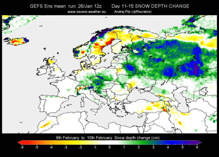
North America snow forecast in this period shows more snowfall across western Canada and the northwestern United States. We can also see increased snow depth in the central United States and the Midwest, extending towards the northeastern United States with transitioning storms. This is just an ensemble forecast but gives an idea of what such weather patterns can provide.
In Europe, we don’t see any significant snow depth increase, except in parts of central Europe, likely associated with a transitioning cold front. More snowfall is expected further east into Russia.
The temperature forecast for this period shows the active pathway for cold air outbreaks from western Canada into the western and central United States. Some cold could reach also the northeastern United States with transitioning storms. Europe is separated into two temperature regions, with colder air remaining more to the north and warmer to the south.
Because the weather is not so simple, there are more factors and dynamics at play than just the stratosphere and the polar vortex. One strong dynamics that will influence the weather in February is the Madden-Julian Oscillation or MJO short.
This is a wave in the tropical regions, alternating wet and dry episodes as it circles the globe around the Equator. On the image below, we can see a wet episode emerging in the western Pacific Ocean. This phase of the MJO usually supports building higher pressure in the North Pacific, which is exactly what you saw on the forecast charts. So there is a strong signal emerging for the influence of the MJO.
You can read much more about this MJO wave, what it is and how it will influence our weather in February, in our recent article, linked below:
We will keep you updated as fresh data is available, and more reliable forecasts are released for the days and weeks ahead. So stay tuned, and don’t forget to bookmark our page to have all the info ready at hand!
