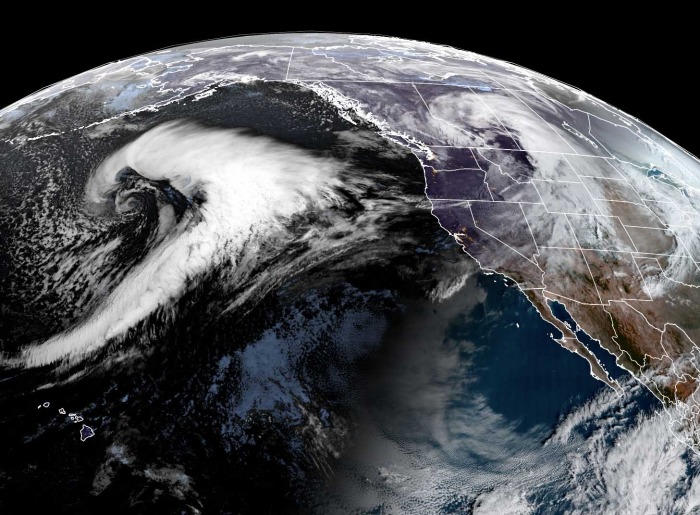
No rest for Alaska. A new large extratropical storm is nearing the Gulf today, developing a dangerous winter storm with severe winds and heavy snow into the southern portions of the state. It is followed by a new explosive storm further west, coming up over the weekend. While further east over the continent, a powerful winter storm is blasting south across the United States with severe damaging winds and cold outbreaks.
The North Pacific region has been producing storm by storm this winter season and has a much above-average number of cyclones. It has also brought record-breaking rains along the Pacific Northwest of Canada and the United States.
Almost every storm literally explodes and reaches a violent strength while moving towards the Aleutian Islands, Alaska mainland, or the Pacific Northwest. Just remember the final day of the 2020 year when the North Pacific and Alaska were hit by the most intense storm on record.
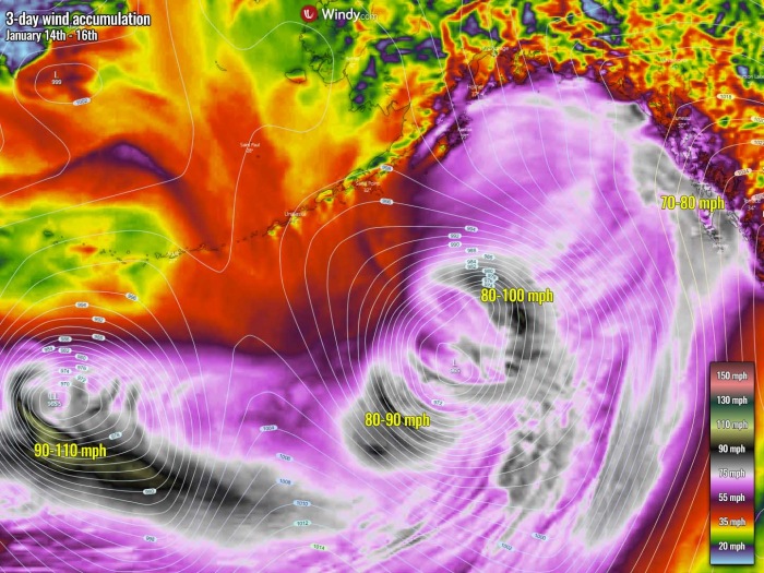
There are now two large storms moving towards Alaska, with the first one forecast to develop a major winter storm with very windy conditions, as well as lots of snow and blizzard for southern portions of the state. The new storm behind it is even more intense, producing 50+ feet waves and hurricane-force winds, gusting above 110 mph.
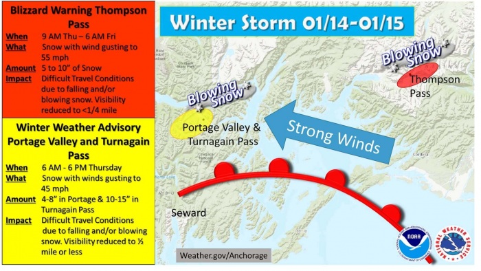
According to the National Weather Service in Anchorage, a WINTER STORM WARNING remains in effect for southern Alaska as strong winds are expected along the warm front moving in from the Gulf of Alaska. It will result in severe blowing snow across the Portage Valley and the Turnagain Pass as well as over the Thompson pass.
A BLIZZARD WARNING is in effect through Thompson Pass until Friday morning as blizzard conditions expected. Total snow accumulations of 5 to 15 inches and winds gusting as high as 55 mph there. Besides the 5-15 inches of snow likely until Friday morning. Travels will be difficult due to whiteout conditions with less than 1/4 miles visibility.
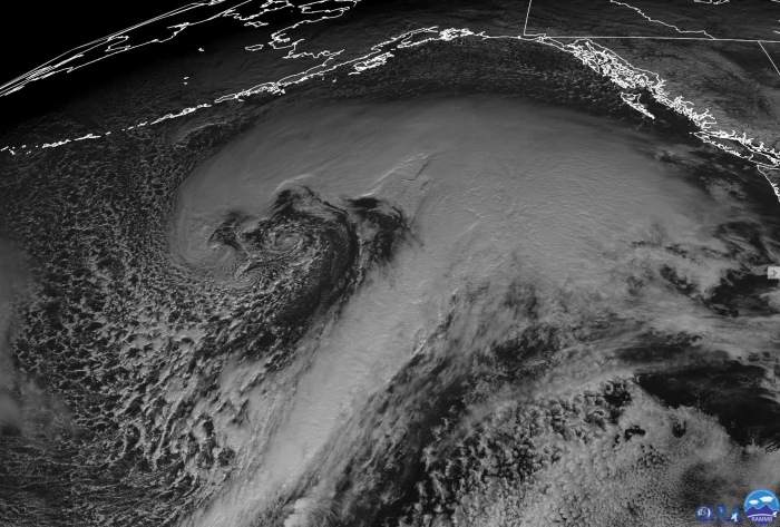
The view of the main system, the rapidly developing extratropical storm on Wednesday was probably the most impressive one. See how large it has become compared to the North Pacific, the United States, and Canada further east. A remarkable storm.
Also, take a look over another system over the continent further east, which is an organizing winter storm from Southern Canada moving into the United States this Thursday. You can read more about this event below:
Both systems’ violent, hurricane-force winds have generated major waves that are gradually being pushed towards Southeast Alaska and the Pacific Northwest, especially by the second storm this time. The impact of the first storm is the greatest today into tonight as the low nears southern Alaska. Another dangerous wind event for the region is likely, including the winter storm and blizzard conditions and quite a lot of snow.
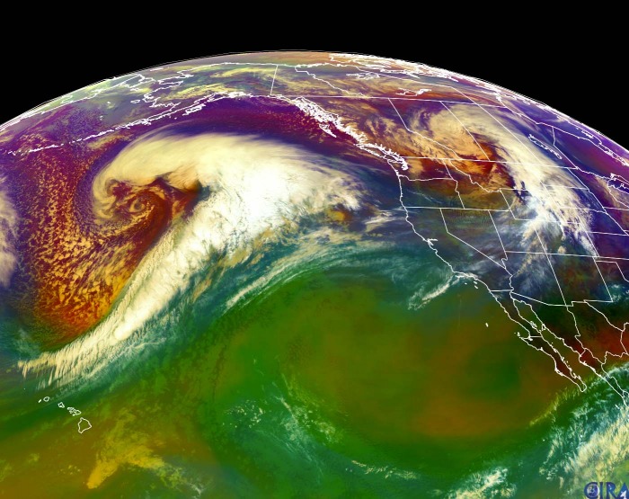
The above remarkable satellite animation reveals the rapid development of both North Pacific storms, seen with the Water Vapor and Airmass satellite scans over the last 48 hours. We can see that both storms are very well-organized and growing their size quite fast. This is yet another example of how progressive pattern sits over the Pacific and how good conditions are in place.
TWINS OVER THE NORTH PACIFIC
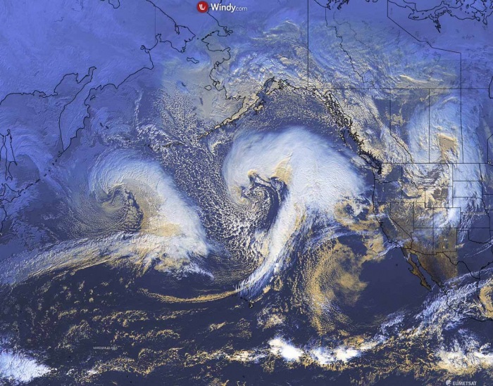
Again, a very explosive intensification of the eastern extratropical storm has occurred on Wednesday, while the second low was already entering its own rapid strengthening further west, to the south of the Aleutian Islands. Both have created a rather spectacular satellite presentation with a textbook cyclonic structure and a warm conveyor belt wrapped into the core. A widespread Arctic maritime air mass is spread between both systems, arriving from the Bering Sea.
Notice there is also a developing another system further east – that is a winter storm over southern Canada and the northern United States today. Together they are forming three waves/systems in the line, the weather pattern is strongly progressive now.
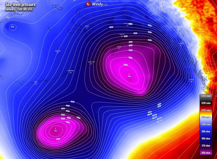
The eastern cyclone has deepened from around 995 mbar on early Tuesday local Pacific time to almost 960 mbar by Wednesday evening, so around 30-35 mbar pressure drop in about 36 hours.
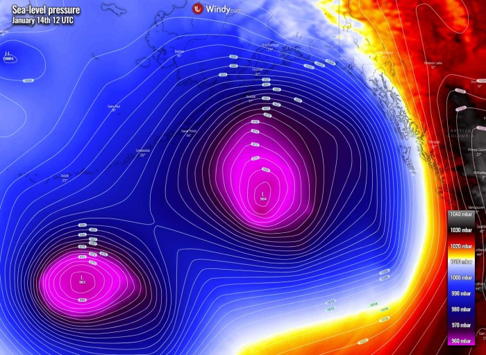
While the new storm over the Aleutian Islands had a central pressure of around 970 mbar at the same time, dropped to around 1005 mbar when it started its rapid intensification near Japan on early Tuesday. Storms have become very large and are now both having the central pressure around 965 mbar this Thursday local morning.
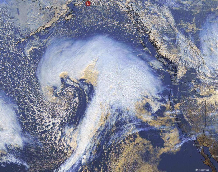
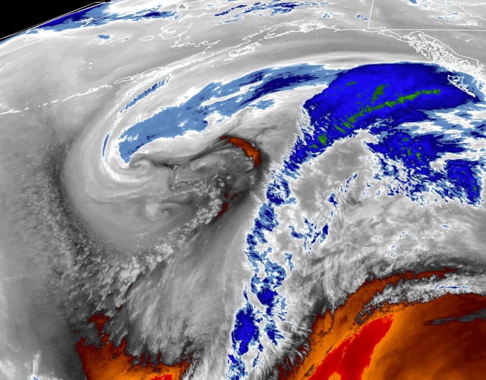
Above is a closer look into the eastern extratropical storm indicates a dry intrusion towards the core of the large low. There are several mesovortices also observed with the large circulation in the core. This is a very good presentation of the dry conveyor belt wrapping into the core, with a textbook appearance of the occluding low and dry intrusion visible. Winds are with hurricane-force speeds, gusting even above 100 mph.
In the above’s high-resolution view of the core’s mesovortices, we can see at least three have formed completely with two more developing. A broad channel of Arctic cold maritime air mass is spread behind the system to its west. A huge comma cloud associated with the warm front is spread northward towards Alaska. Image is provided by NOAA/CIRA.
The mesovortices are even better visible on the CIRA/RAMMB NOAA satellite view in the Water Vapor channel. The storm has become very large, and so did its core. All three vortices can be easily found, circulation around the dead core of the low. A wide dry conveyor belt wrapping into the system is also quite large, extending out and meets the cold advection on the western edge, coming down from the Bering Sea and the Aleutians.
PACIFIC KEEPS GENERATING EXPLOSIVE STORMS
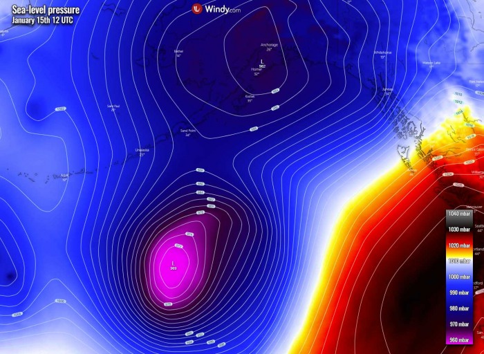
The central pressure of both storms has reached near 965 mbar by Thursday morning. The eastern extratropical storm has actually peaked at 961 mbar last night, while the new storm to the west is likely near its peak today. Again, as it happened less than a week ago, the eastern storm continues northeast across the North Pacific, heading for the Gulf of Alaska with yet another winter storm for the state tonight. The second storm follows it.
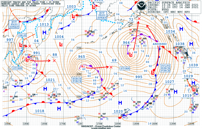
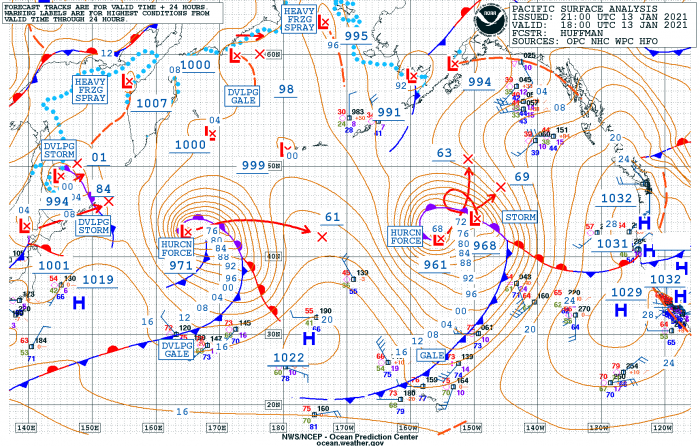
Thanks to the strong upper-level ridge and surface high-pressure system over the Pacific Northwest (yes, thankfully there is at least some relief in this record-breaking wet season there) of the United States and Canada, the front storm will turn sharp north towards southern Alaska today and tonight. Below are the estimated surface analysis data for the mean sea-level pressure by the NOAA Ocean Prediction Center (OPC) for the eastern storm:
- 964 mbar at 12 UTC, Jan 14th
- 963 mbar at 00 UTC, Jan 14th
- 960 mbar at 12 UTC, Jan 13th
- 977 mbar at 00 UTC, Jan 13th
- 994 mbar at 12 UTC, Jan 12th
- 1000 mbar at 00 UTC, Jan 12th
So as we can see from the data above, the central pressure in this extratropical storm has had an impressive 34 mbar pressure fall in the 24-hour period between Tuesday 12 UTC and Wednesday 12 UTC timeframes. With an explosive strengthening between 12 and 00 UTC on Tuesday as 17 mbar pressure drop occurred in a 12-hour period only. Keep in mind that this fits well above the threshold for the bombogenesis – a bomb cyclone with the definition of pressure change of 24 mbar in 24 hours.
The new system rapidly forming further west was not far behind with its intensification either. It was actually having its pressure fall quite similar to the front storm, as can be analyzed by NOAA OPC data below. As it is rather typical this year, it had a 37 mbar pressure drop in the same period as the first system, between Tuesday 12 UTC and Wednesday 12 UTC. Then it has slowed its rapid strengthening down.
- 965 mbar at 12 UTC, Jan 14th
- 965 mbar at 00 UTC, Jan 14th
- 970 mbar at 12 UTC, Jan 13th
- 991 mbar at 00 UTC, Jan 13th
- 1007 mbar at 12 UTC, Jan 12th
- 1014 mbar at 00 UTC, Jan 12th
This storm also had a very explosive intensification period, as the first one. The 12-hour pressure fall between 00 and 12 UTC on Wednesday was 21 mbar!
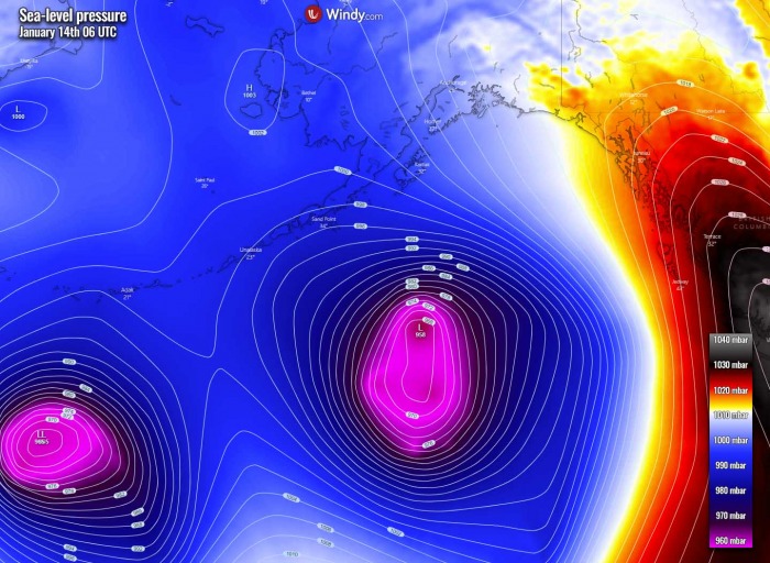
We can actually see that both systems are having similar central pressure this Thursday, near 964-965 mbar. Actually, the western extratropical storm has arrived in the wake of the first one where a colder air mass in the eastern storm’s wake is being ingested into the second one. In other words, this means the latter is struggling to keep its violent strength as a lack of a warmer environment is in place to boost its strength.
DOUBLE TROUBLE (TWIN STORMS) AGAIN
The eastern system continues moving towards the northeast this Thursday, heading for its potentially severe impact of a winter storm on southern Alaska. The second storm is already coming behind it. Both storms are intense, where the eastern low is maintaining lower central pressure until tonight. But both have peaked. While the western storm is progressing east, the front storm is turning north, thanks to the ridge to its east over the northwestern United States.
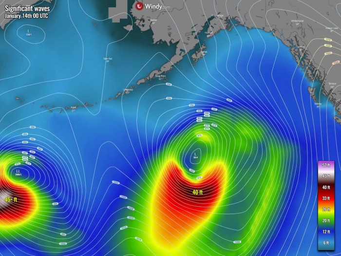
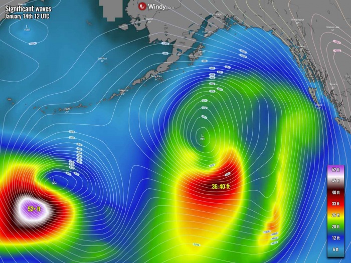
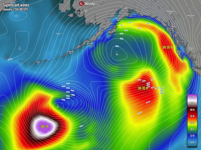
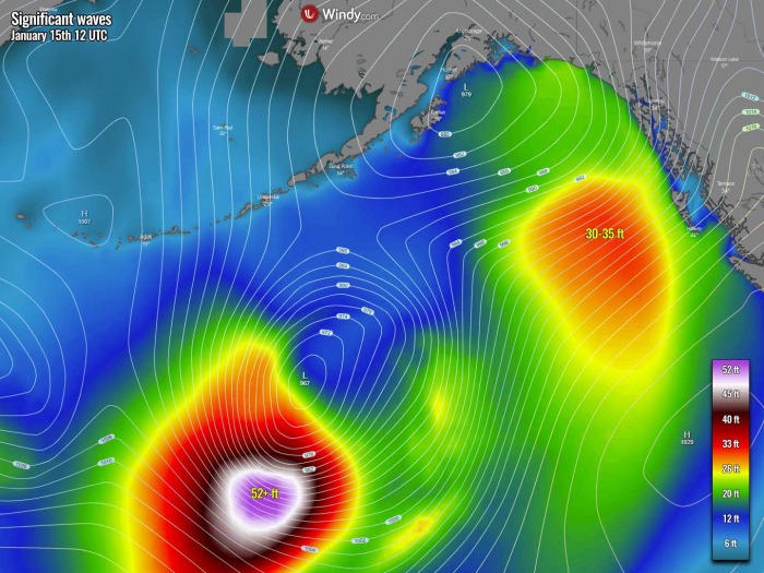
As both storms have had rapid strengthening, the violent winds are generating major waves. Those are lower with the eastern storm, around 40 feet while the western storm is very likely having much more significant height, probably more than 50-52 feet high waves. Thanks to more explosive development.
However, the east is the biggest so also the winds/waves are spread across a broader area. Fortunately, the wind maximum and the waves of both storms are staying far from the coast, otherwise, they’d be destructive for the coast.
MAJOR WINTER STORM FOR ALASKA TONIGHT
With the first storm near the peak and coming closer to Alaska, a strong pressure gradient spreads towards Southeast Alaska, but also towards southern Alaska further north. This means winds are increasing and becoming severe in places and winter storm conditions develop, especially across the higher peaks and mountain passes where also channeling flow normally brings more violent speeds. Both systems will peak today but remain large tonight into early Friday.
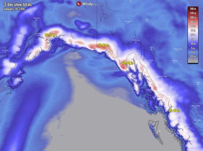
As the precipitation is also increasing, a combination of a strong winter storm and winds will impact driving conditions due to blizzard and blowing snow. The amount of snow until the end of the weekend is nothing less than exceptional, despite the mountains are used to extreme amounts on a normal year.
But it has been even more extreme this year, similar to the record-breaking precipitation amount across the Pacific Northwest, of both Canada and the United States.
While the Pacific Ocean further south of both storms remains under high wind and waves threat. The waves stay significant through Thursday night with 35-40 feet with the eastern storm and still more than 52 feet with the western storm. Those are gradually spreading towards Southeast Alaska, along with the increasing pressure gradient.
According to the National Weather Service of Juneau, Alaska, a WINTER STORM WARNING remains in effect until Friday morning as both heavy snow and winds are expected, with the total snow accumulations up to 12 inches across Haines Highway near Haines Border Customs.
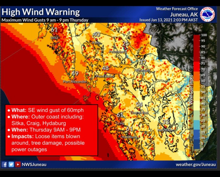
A HIGH WIND WARNING remains in effect for the Southeast Gulf Coast including the cities of Hydaburg, Craig, and Sitka as winds of 30 to 40 mph with gusts up to 60 mph are expected.
Some areas could see even more than 70 mph gusts. Damaging winds could blow down trees and power lines. Widespread power outages are possible. Travel will be difficult, especially for high profile vehicles. The second storm further west as even stronger winds, but those are thankfully the strongest today and will be weakening while the storm continues east into Friday.
FRIDAY: EASTERN STORM WEAKENS, WESTERN ONE REMAINS STRONG
As we can see, both storms mature and peak this Thursday, but their trajectory is turning north-northeast now. The first storm (eastern) maintains a strong pressure gradient across Southeast Alaska on Friday. The isobars (lines with the same surface pressure) are still very close together, so the winds will remain strong but gradually slowing down as the storm continues weakening towards the evening. The second storm further southwest remains intense, with a strong pressure gradient.
How intense the western storm is, can be easily judged by the strength of the wind field and also significant wave height. Those should remain very high until Friday, keeping the highest waves above 50-52 feet likely until the evening hours. But those remain away from any land areas. Although the eastern storm will be in a weakening process, its large size will keep the waves around 30-35 feet high when they finally reach Southeast Alaska.
Towards Friday afternoon/night, the eastern storm weakens quite rapidly and moves north into the interior of Alaska’s mainland. The pressure gradient vanishes, so do the winds. Although the snowfall will remain over both southern and Southeast Alaska, weaker winds will allow high-wind warnings to end during the day. The second storm should come closer, but also weakening its intensity despite remaining large.
The size of it and still quite a strong pressure gradient around it will help the waves to remain significant, still more than 50 feet to the south of the core. This is quite impressive if we remember that those were already this high from Wednesday afternoon, so also two days of such monster waves. Those will be gradually coming down as the storm moves towards Alaska and weakening into Saturday.
***The images used in this article were provided by Windy and NOAA.
SEE ALSO:
