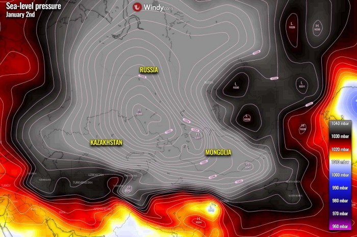
We have seen the year 2020 was, weatherwise, a remarkable and deadly year by various extreme weather events. Including the record-breaking Atlantic hurricane season, wildfires in Siberia, and winter storms in both Europe and the United States. And the year ended with a bang, setting a new North Pacific low-pressure record of 921 mbar as a powerful extratropical storm hit Alaska on the last day of 2020. While just a day earlier, a new world record for high-pressure has been set in Mongolia, 1094 mbar!
As we have been writing about in our initial Wednesday’s discussion regarding the potential record-breaking evolution of this storm, the North Pacific, Alaska, and the Bering Sea have set a new record for the lowest central pressure of an extratropical storm. The lowest central pressure with this storm was 921 mbar over the North Pacific on the last day of 2020, Dec 31st.
While the center of the low crossed the Aleutian Islands, the nearest weather station Shemya island of the Alaska weather station network recorded 924.8 mbar, breaking the previous record of 926 mbar set at Dutch Harbor on October 25th, 1977.
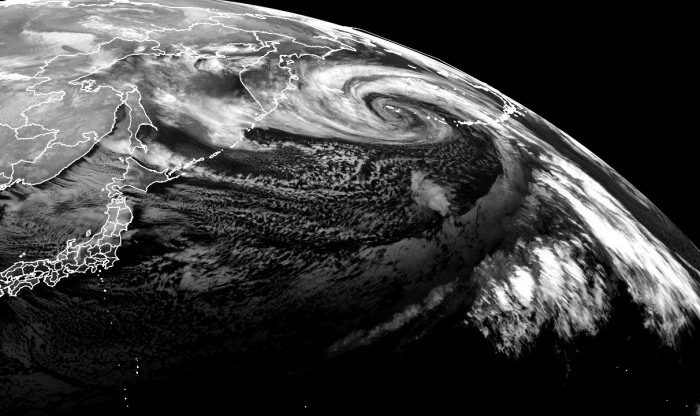
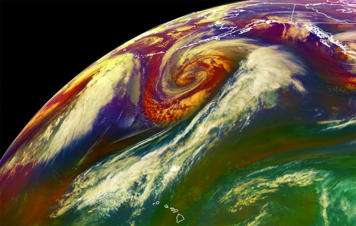
When the system moved into the Bering Sea, it also set a new minimum central pressure of 921 mbar, becoming the deepest storm in the Bering Sea on record. The last storm with so deep pressure were remnants of Super Typhoon Nuri.
The North Pacific hardly sees any rest this winter and this storm was no exception for the region. A combination of the deep Arctic cold over Siberia, the advection of a warm Pacific tropical air mass, and the extremely powerful 250 mph jet stream between these two air masses have resulted in a very *explosive* development of an extratropical storm and bottom out at 921 mbar, right in the time the storm was about to cross the Aleutian Islands.
There were many intense mid-latitude cyclones (extratropical lows) lately and North Pacific is showing no signs of easing off anytime soon. More storms are on the way in the coming days, including a potentially very dangerous extratropical storm nearing Alaska mainland and Southeast Alaska this new week.
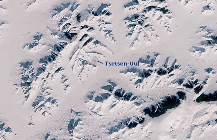
The extreme cold over parts of Asia mentioned earlier above, has also set another extreme record for air pressure – a world record for the highest sea-level pressure! The Mongolian weather station Tsetsen-Uul’s mean sea-level pressure rose to an unprecedented 1094.3 mbar (or 32.31 inches). This broke the previous record of 1089.4 mbar set on Dec 30th, 2004 at the same station.
Let’s see how the storm evolved in the final days of 2020, which has led its central pressure to become the lowest on record for the North Pacific Ocean, Alaska, and the Bearing Sea.
FROM JAPAN TO BERING SEA IN TWO DAYS
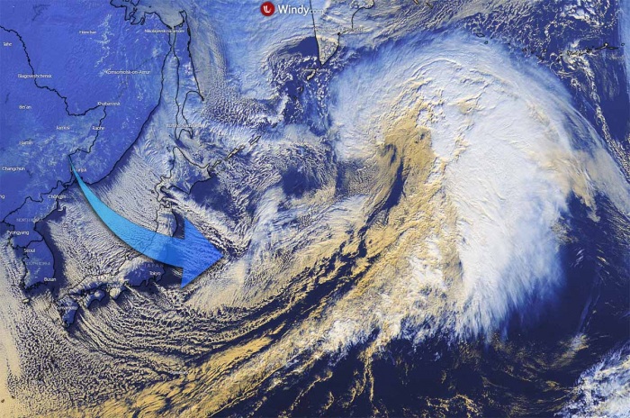
The deep Arctic air, originating over Siberia, has met a tropical air mass being advected from the Western Pacific warm pool. Ocean sea surface temperatures there are normally at around 30 °C year-round. A very extreme temperature gradient took shape in between them with a very powerful jet stream in the upper troposphere (110 m/s at 200-300 mbar) separating the two air masses.
And the geography of Central/Eastern Asia favored the merging of the otherwise mostly separated polar and subtropical jet streams. The cyclone has formed in a region of a very favorable upper-level divergence, underneath a combined left exit and right entrance regime of two upper-level jet streams. The interaction with the strengthening upstream jet streak resulted in the surface low’s further deepening.
The low has formed near Japan on Tuesday and has been deepening steadily but rapidly strengthening through Wednesday when an explosive intensification started as a much faster pressure falls rate, while the storm was moving to the south of the Kamchatka Peninsula. The system headed straight for the Aleutian Islands and the Bering Sea for the last day of the year, right for New Year’s Eve 2020. It grazed across the westernmost islands of the Aleutians with extremely powerful, life-threatening hurricane-force winds and major destructive waves.
The background effect leading to this storm’s evolution and its explosive development was an impressive, extremely cold with below -55 °C spread across parts of Siberia, Russia after Christmas. The advection of this cold air mass was rushing eastward across Japan and the Northwest Pacific Ocean, dumping around a meter of fresh snow across the main, central Japan island. As this deep and extreme cold Arctic air mass interacted with the strong Pacific jet stream, the result was a very *explosive* nature of the storm’s rapid intensification.
The pressure falls of nearly 60 mbar per 24 hours and 75 mbar per 36 hours were also very near or even a record-breaking pressure changes in the North Pacific basin.
The extratropical storm brought a broad area of hurricane-force 85+ mph winds to most of the waters west of Unalaska and the Pribilof Islands beginning Wednesday evening through Friday. In addition to hurricane-strength winds, this monster storm generated significant wave heights, with a potentially record-breaking height of 58 feet (almost 18 meters) on the Pacific side of the Aleutians from Adak to Attu Island on Thursday. Such waves are destructive when they hit the coast.
The system took almost the same track as the intense extratropical storm last weekend, which bottomed out at 939 mbar on Sunday, Dec 27th. It blasted across the southwestern portions of the Aleutian Islands with extremely powerful winds and very significant, 55+ feet waves.
This low has also become the most intense Earth’s storm of the year!
EXTREME 75 mbar PRESSURE DROP IN 36 HOURS
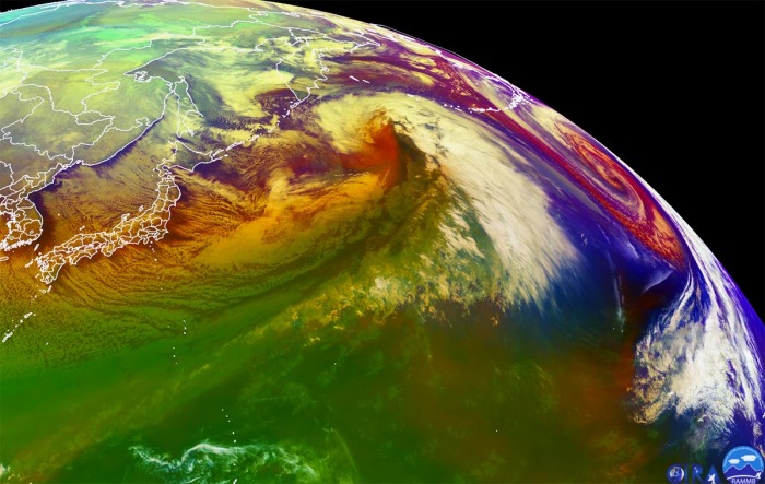
When moving south of the Kamchatka peninsula, the low has deepened to 960 mbar as of 18 UTC Wednesday (local morning), with a deeping pressure of around 10-15 mbar per 6 hours period. The system was already an impressive monster storm by then. There was a textbook appearance of an explosively strengthening extratropical storm, as seen by the airmass satellite scan below. With a well-defined dry intrusion visible, being pushed into the storm from the southwest.
The surface pressure analysis below reveals this extratropical storm evolution from its birth near Japan on Tuesday, Dec 29th, entering the explosive intensification while gradually growing its size and rapidly lowering its central pressure through Wednesday. Then, it deepens considerably on Thursday when the peak, lowest central pressure, has been reached in the morning hours (local Pacific/Alaska time):
- 923 mbar at 00 UTC, Jan 1st
- 921 mbar at 18 UTC, Dec 31st
- 921 mbar at 12 UTC, Dec 31st
- 928 mbar at 06 UTC, Dec 31st
- 941 mbar at 00 UTC, Dec 31st
- 960 mbar at 18 UTC, Dec 30th
- 972 mbar at 12 UTC, Dec 30th
- 986 mbar at 06 UTC, Dec 30th
- 996 mbar at 00 UTC, Dec 30th
- 1001 mbar at 18 UTC, Dec 29th
- 1008 mbar at 12 UTC, Dec 29th
As we can see from the pressure analysis above, the central pressure in this extratropical storm had an *EXTREME* 75 mbar pressure fall over the 36-hour period (from 996 mbar to 921 mbar) between Wednesday, Dec 30th 00 UTC and Thursday, Dec 31st 12 UTC. This is very likely also near or even a record-setting pressure change for the basin. The largest pressure change within a period of 24 hours was a remarkable 58 mbar pressure fall between Dec 30th 06 UTC and Dec 31st 06 UTC (from 986 mbar to 928 mbar).
Here is the OPC NOAA pressure analysis across the North Pacific at the time of the peak intensity on Thursday morning. Notice there was also another strong system to its east.
Its rapid intensification rate was so explosive, that its central pressure fall was more than double the threshold for a bomb cyclone*.
*Bomb cyclone or a bombogenesis is a meteorological term that describes a mid-latitude cyclone (a so-called extratropical low or storm) that rapidly intensifies. Both with winds and indeed its central pressure.
The bombogenesis process occurs when an extratropical storm rapidly intensifies, dropping its central pressure at least 24 millibars over 24 hours period. A millibar measures atmospheric pressure. This can happen when a cold air mass collides with a warm air mass, such as air over warm ocean waters, and leads to an explosive strengthening of the storm.
The formation of this rapidly strengthening weather system is a process called bombogenesis, which creates what is known as a bomb cyclone.
As the National Weather Service in Anchorage, Alaska has tweeted on Friday, a new Alaska land-based low-pressure record has been set! The mean sea-level pressure at the Shemya Islands dropped to 924.8 mbar at 22 UTC (local 1 pm Alaska time). The previously accepted record was from a ship in Dutch Harbor at 925 mbar, measured in 1977.
The storm’s hurricane-force winds and significantly high waves have also lead to remarkable wave heights at the oceanic NOAA buoy #46071, located on the Pacific side of Amchitka Island, Alaska. The highest wave height was reported at 58.1 feet. That is 17.7 meters!
The strongest wind gusts recorded at Shemya Island were up to 83 mph (133 km/h) in the hours prior the record-breaking pressure readings were set.
NEW WORLD RECORD FOR HIGHEST PRESSURE IN MONGOLIA
But there was also another remarkable effect of the extreme cold over Russia. As it typically occurs during very cold temperatures, the denser, cold air sinks and result in the surface high-pressure rising into very high values. This has happened also this week over central Asia and pushed the barometers into some unprecedented values.
Actually, a new world record for the highest mean sea-level pressure has likely been set in a high mountain valley (plateau) in Mongolia, central Asia. An automatic weather station located in Tsetsen-Uul, western Zavkhan province, Mongolia has recorded a mean sea-level pressure of 1094.3 mbar along with bitter temperatures of -45.5 °C (-50 °F).
Three other weather stations have also reported pressure reading higher than the existing pressure record from 2004, so the records from Tsetsen-Uul aren’t just a reading error or a transmission error. If these records will be verified, it will break the previous world record of 1089.4 mbar also set in Mongolia, exactly 16 years ago.
According to the World Meteorological Organization (WMO), the previous highest pressure reading was set at two stations, both in Mongolia. Weather station Tsetsen-Uul and Tosontsengel have both recorded pressure of 1089.1 mbar (1089.4 mbar if using Russian method) on December 30th, 2004. It has to be noted that Tosontsengel’s elevation is 1725 meters (5658 feet) above sea-level while Tsetsen-Uul’s elevation is 1928 meters (or 6325 feet) above sea-level. These are high mountain valleys on the plateau.
On 30 December 2004 in Tosontsengel Mongolia, at 2 am local time on the 30th, (18/1800 UTC) the station pressure rose to 846.5 hPa. Using the supplied station pressure of 846.5 hPa, a geopotential height of 1725.8 m and an ambient air temperature of -44.8 ºC, the WMO method for reduction to sea level pressure produces an adjusted sea level pressure value of 1089.1 mbar.
See more details in the WMO article here: The Tosontsengel Mongolia world record sea‐level pressure extreme: a spatial analysis of elevation bias in adjustment‐to‐sea‐level pressures
It is for now still an unofficial value, as WMO has normally taken time for deep analysis of the environment. But it is also interesting to see that the surface temperature of around -45 °C (-49 °F) at Tsetsen-Uul at the time of the peak surface pressure records was close to those readings from the day the previous record was set, -44.8 °C (-48.6 °F). This is very important information as it gives the 2020 readings a good potential to be confirmed by the analysis later.
For your reference; According to the meteorologist Bob Henson, the highest sea-level pressure ever recorded in the United States mainland is 1078.8 mbar, set in Northway, Alaska on January 31st, 1989. The Canadian record was set two days later, on February 2nd, when 1079.6 mbar pressure readings were recorded at Dawson City, Yukon.
Note: The highest values of the mean sea-level pressure normally occur in frigid winter months with snow on the ground, as dense air sinks towards the surface, e.g. in the valleys. When the night skies are clear and strong temperature inversion forms, almost no wind is present which helps the cooling air to sink towards the bottom of the valley and become even colderm as it doesn’t mix with the lack of winds. And the temperatures are much lower in the bottom of the valley than it is along the surrounding slopes.
BRUTAL COLD OVER SIBERIA
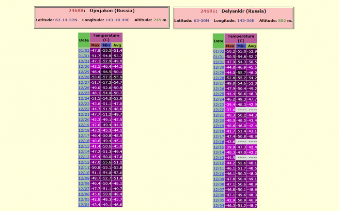
The infamous Russian frigid cold town of Ojmjakon and surrounding towns Nera, Delyankir, Yurty, and Agayakan were lately reporting morning temperatures of around -55 °C (-67 °F) and were definitely a huge factor leading to the evolution of the explosive extratropical storm over the Northwest Pacific Ocean. The advection of Arctic cold air mass has also introduced an intense sea-effect snowfall from the Sea of Japan into Japan’s main island Honshu. Locally more than 3 feet (1-meter or 100 cm) of snow has been reported there.
Although the Russian region of Siberia is indeed used to frigid cold temperatures during the winter months, temperatures below -55 °C are still very extreme there! Attached below are the morning temperatures in Ojmjakon and Delyankir over the last 30 days. We can see that the extreme cold has become even more intense after Christmas, and it continues into January 2021.
MORE INTENSE STORMS HEADING FOR ALASKA THIS WEEK
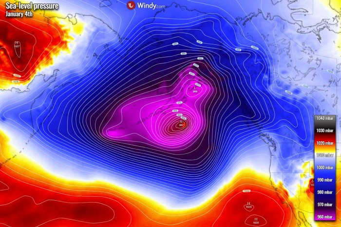
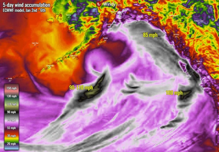
The overall very active pattern across the North Pacific continues, so new extratropical storms are expected in the coming week. The largest storm is likely to arrive on Tuesday and would potentially be quite intense. The ECMWF model guidance suggests that its central pressure would push even below 950 mbar while the storm will be moving with its center just south of the Aleutian Islands towards the Gulf of Alaska.
This new extratropical storm is then forecast to move closer to the Alaska mainland and gradually losing its strength through the mid-week days. As its development will be quite rapid again on Sunday into Monday, it will likely form violent, hurricane-force winds to the south of its core. Peak gusts up to 110 mph seem possible there.
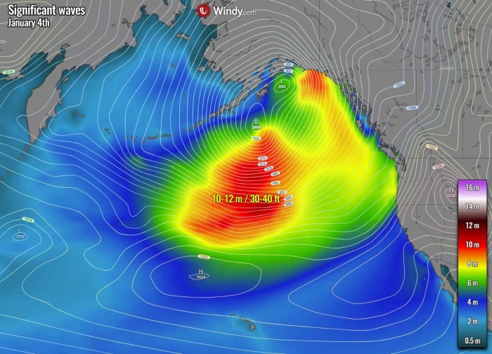
The whole circulation over the far North Pacific and the Gulf of Alaska will be huge and the pressure gradient quite significant. This will help the overall windy conditions to become severe. Another wave with a small but intense surface low will push towards Southeast Alaska already on Monday and could bring violent winds and high waves to the southern portions of the region and the Pacific Northwest.
It should bring another 4-8 inches of precipitation further inland into the mountains, and indeed huge snowpack with potentially additional 50-80 inches of new snow over the next five days.
Violent winds associated with this Monday’s low and the new large storm on Tuesday will generate significant waves of 8-12 meters towards the coast of Southeast Alaska and the Pacific Northwest of western Canada and the United States.
We will be posting further updates in the coming days, stay tuned!
