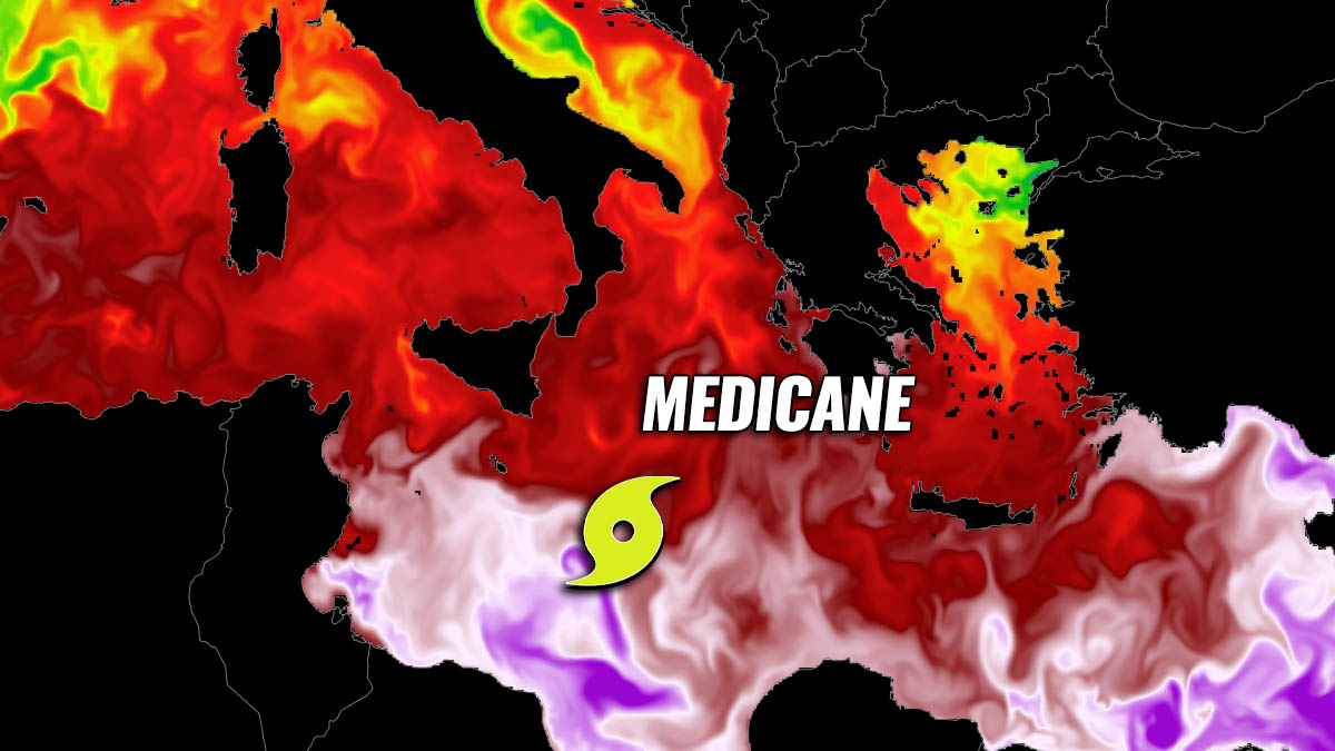
An extreme anomaly of seawater temperatures in the region between Italy, Malta, Greece, and Libya has led to a formation of an intense Tropical-Like Cyclone (TLC). TLC is a surface low that attains tropical characteristics, known as a Medicane in the Mediterranean Sea. Medicanes are severe weather events that often bring destructive impacts to the areas affected. After deadly floods in Sicily recently, more heavy rain and flooding is possible as the system re-intensifies over the next 3 days.
Medicane, the Mediterranean tropical-like Cyclone (TLC) is something you’ve probably heard in the news headlines this week. The first such event of this autumn has formed south of Italy and is expected to re-intensify through Friday with potentially significant impact on the land.
While the exact track of the re-developing system has some uncertainties seen by different weather models, severe damaging winds and flooding threats could be significant for southern Italy, with additional heavy rain and enhanced floods potential. But Also Malta and northern Libya both have to keep an eye on the medicane development through Friday.
Below is a brief overlook of the weather model solution forecast throughout the development of the medicane. The animation includes a forecast for 10 m winds, 850 mbar temperature, and a precipitation forecast.
As we can see from the three most important geopotential levels in meteorology, the surface, 500, and 850 mbar charts, they clearly resemble the warm-core system with air mass temperatures being the highest near the traveling core of the system.
But first, what exactly is the Medicane and how often do they form? These tropical-like cyclones in the Mediterranean appear very impressive to observe by the satellite/radar imagery but they are dangerous severe weather events. The majority of medicanes form in the Mediterranean region, but they can also develop in the Black Sea on rare occasions.
WHAT IS A MEDICANE OR A TROPICAL-LIKE CYCLONE (TLC)?
Tropical-like storms or cyclones that form in the Mediterranean region, are also known by their popular name medicane. These are cyclones that attain subtropical or even tropical characteristics and can produce violent convective storms with severe winds and torrential rainfall impacts.
Very similar to the surface cyclones in the tropical region, Tropical-Like Cyclone (TLC) is a warm core system that often closely resembles tropical cyclones in satellite imagery. A fully-developed medicane has textbook tropical characteristics, with clear circular eyes, surrounded by an eyewall and axisymmetric cloud pattern. Including the upper-level outflow ventilation, so having close similarities to the tropical cyclone.
Above: Medicane system south of the Crete Island, Greece in December 2005. Image: NOAA
Tropical-Like Cyclone or Medicane systems typically reach gale to storm force strength. However, the strongest medicanes of the recent decades have even reached hurricane-force wind strength. Thus they pose a very significant severe wind and rain threat to the impacted regions along the Mediterranean coast. Often, major floods occur.
Medicanes are an annual occurrence, appearing on average about 1-2 times each year. They can form throughout the year but are by far most likely to form between September and January, so during the autumn and winter months.
These systems typically form under upper-level troughs or cut-off upper lows that are characterized by very cold air mass aloft moving over the still very warm Mediterranean sea. This leads to strong instability and convective thunderstorms.
Unlike tropical cyclone formations in the Atlantic Hurricane Season or Pacific Ocean Typhoon Season, the tropical-like cyclone in the Mediterranean can form with sea surface temperatures below 26 °C.
MEDICANE BRINGS DESTRUCTIVE AND DEADLY FLOODS TO SICILY, ITALY
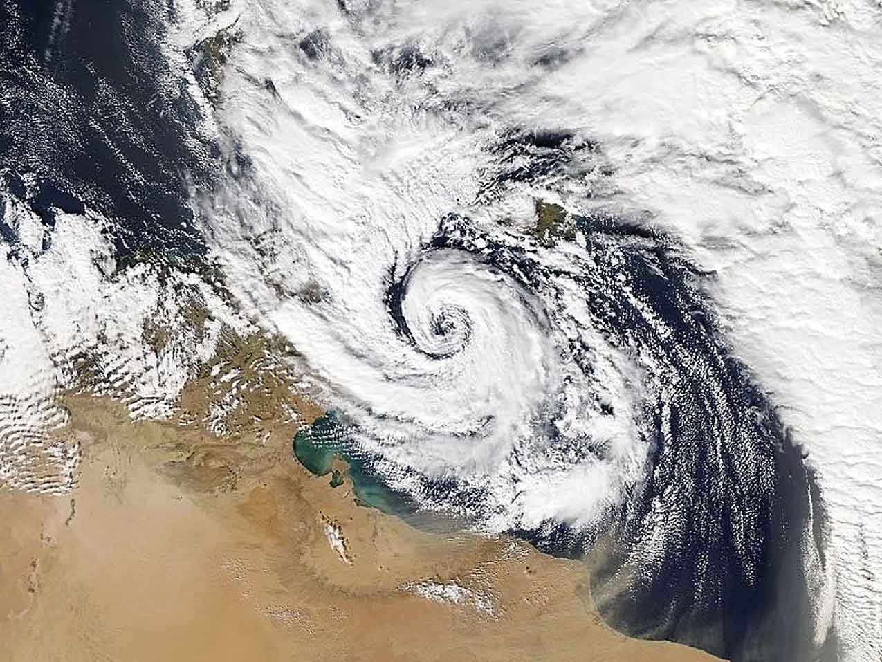
Earlier this week, this rare meteorological event has developed to the south of Italy, over the extremely warm waters of the southern Mediterranean. Water temperatures are around 5 °C warmer than normal for the end of October. The medicane has brought a tremendous amount of rain that battered Italian island Sicily and the Calabria region.
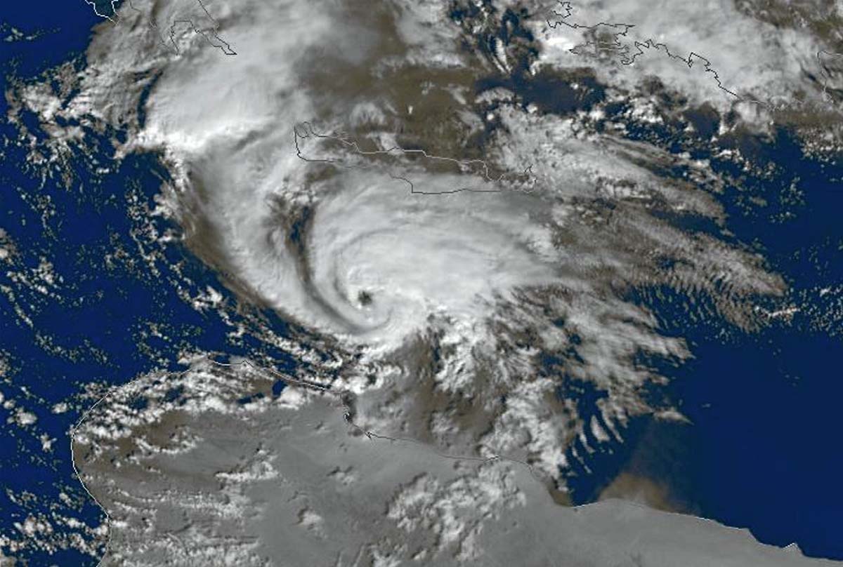
This Thursday morning, the medicane has revealed an already impressive shape of gradual re-development with a textbook cyclonic shape of the convective cloud bands. It is moving northwest towards Sicily.
Destructive floods have become deadly, killing at least two people with some parts of the Italian island submerged by gallons of water. A large part of the Catania city squares and streets are flooded by high water levels, while widespread flooding has left the surrounding city areas underwater as well.
More than 500 mm (20 inches) of rain has fallen in a matter of about 48-72 hours, which is almost half the average amount on this Mediterranean island in a year. Heavy downpours have prompted emergency authorities to issue the red alert warning for parts of Sicily and Calabria in southern Italy. The warning includes a potential risk to life and damage to property with destructive flooding.
The highest rainfall totals accumulated between Sunday and Tuesday were reported from Linguaglossa, Sicily, with 520.4 millimeters (20 inches). The city of Catania reported 167 millimeters (7 inches) in 24 hours, more than twice the average October rainfall of 62.7 millimeters (2 inches).
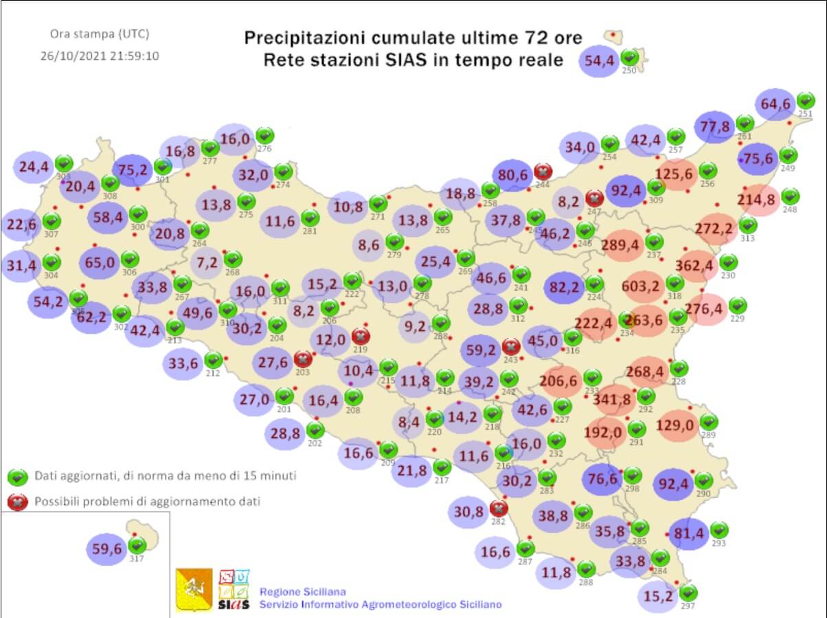
The ciy of Fabrizia, Calabria region has reported 440.2 millimeters (17 inches) as well. Mongiana (Calabria) reported 350.4 mm, Seguono Chiaravalle Centrale received 358.2 mm, and Antonimina Canolo Nuovo 314.4 mm.
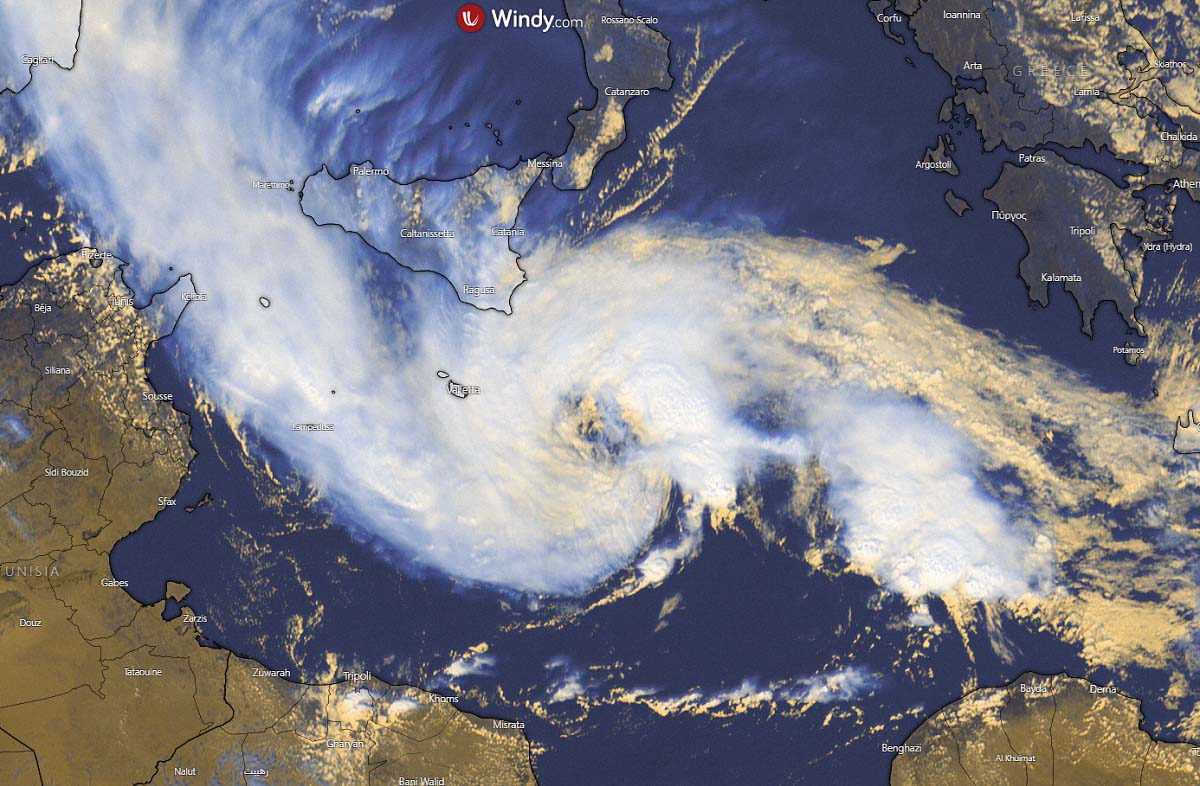
The large area of storms associated with the medicane further south has been meandering around southern Italy and Malta from Tuesday through Wednesday, with continuing heavy rain and locally severe gusty winds in the region.
The weather conditions in place over this part of the Mediterranean Sea are now near-ideal for these kinds of cyclonic formations. Let’s find out what else do we know about these systems and why are they particularly dangerous events.
WHAT CONDITIONS BRING TROPICAL-LIKE CYCLONES AND MEDICANE TO FORM
In the tropical region, cyclones form in low wind shear environments and similar conditions are required by tropical-like cyclones or medicanes to form in the Mediterranean Sea region. From the past studies, we have found two preferred areas of occurrence that have been statistically the most active. The Ionian sea and in the western portions of the Mediterranean Sea around the Balearic Islands.
Note, that also the very warm waters of the Black Sea could produce or fuel intense convective storms that begin cyclonic rotation. Those do appears quite similar to tropical-like cyclones (TLC) observed in the Mediterranean. Over the last two decades (20 years), there were two cyclones reaching sub-tropical storm-force intensity, one TLC was in August 2002 and another one in September 2005.
Above: medicane Qendresa tracking towards Malta on November 7th, 2014. Image: NASA
The size and strength of tropical-like cyclones are constrained by the enclosed environment of the Mediterranean Sea region. The largest medicanes can reach a size of about 300 km (200 miles) and may approach or even reach hurricane intensity.
Mediterranean tropical-like cyclone events typically persist between 12 hours and 5 days and undergo three phases during their lifetime:
- 1. Pre-eye: A strong convective activity that is occupying most of the cyclone.
- 2. Stationary phase: an eye or similar feature forms, surrounded by axisymmetric structure to the cyclone. Strong winds and heavy rainfall develop. But the lightning rates drop as an enclosed warm-core form.
- 3. Itinerant phase: The final stage is characterized by fast, directional motion of the medicane, often due to the interaction with the approaching frontal wave. Less rainfall, but strongest, most severe winds follow in this phase.
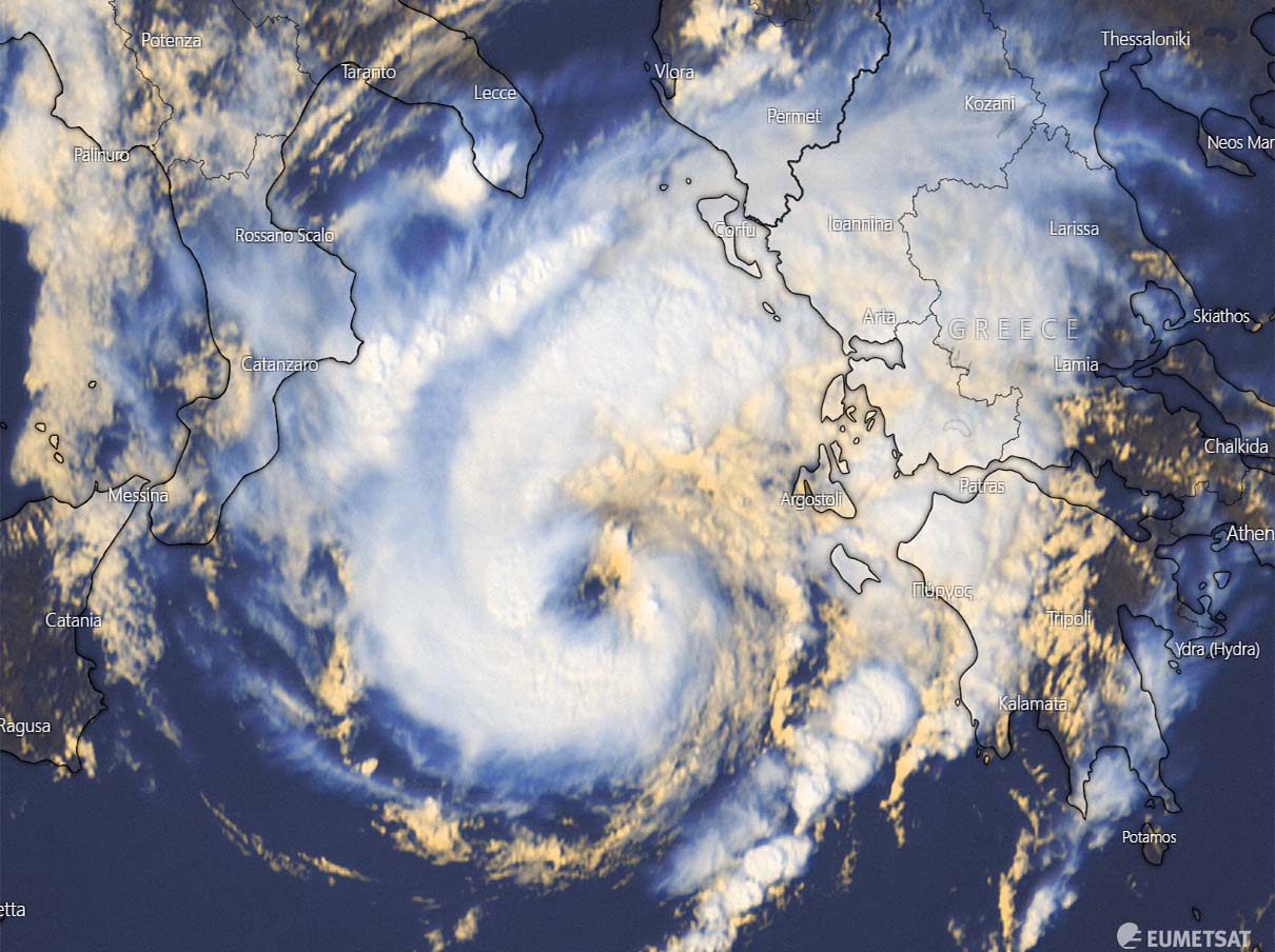
While the first phase normally occurs over the sea, the most dangerous phases are and second and the third as medicane can track to the coastal areas. There are a number of medicane events when the cyclones made a devastating landfall in Greece, Italy, Malta, Algeria, and Tunisia. Such examples were Zorba and Ianos in recent years.
Medicane Zorba makes landfall in Greece, September 29th, 2018. The satellite image displays vigorous convection with a nearly complete eyewall, a distinct eyewall and some dense cirrus overcast. Image: NASA Worldview
Medicane cyclones are considered potentially dangerous due to quite dense population of coastal regions along the Mediterranean Sea. The peak attainable strength of the most intense medicanes is estimated to be equivalent to a Category 1 hurricane on the Saffir-Simpson scale in the Atlantic Basin.
THE STRONGEST MEDICANES IN THE MEDITERRANEAN ON RECORD
While the majority of the medicane formations do not become significant systems and reach coastal areas, some of them do. In September 1969, a powerful medicane formed over the south-central Mediterranean and produced a major flooding event, leaving 600 deaths and more than 250.000 people homeless in Algeria and Tunisia.
Another intense medicane – Celeno occurred in January 1995 and developed peak wind gusts of 135 km/h.
In October 1996, a medicane Cornelia formed in the Tyrrhenian sea, producing 90 km/h winds as far as 100 km from the center and made significant wind/rain damage in the Aeolian Islands.

Above: Medicane Cornelia in October 1996. Image: EUMETSAT
There was another pretty intense Medicane Quedresa, forming on November 7th, 2014. It made a direct hit to Malta with a well-developed shape and a distinct eye at the time of landfall on the island. The system’s 10-minute sustained winds reached 111 km/h with peak gusts up to 154 km/h. The minimum central pressure bottomed out at 978 mbar.
Over the last 10 years, there were a few strong medicanes as well. One of them was a medicane Numa in 2017 that produced a hurricane-like satellite structure, including some upper-level outflow ventilation cirrus shield visible.

In September 2018, a severe medicane Zorba hit southwest Greece producing winds over 100 km/h, major waves and damaging up to 1.5 m storm surge along the coastal western Greece.
A powerful Medicane Ianos that formed on September 16th, 2020 was the first event of the 2020/21 Mediterranean medicane season.
Ianos made a severe impact with flooding and severe damaging winds to western Greece.
EXTREMELY WARM WATER OF THE SOUTHERN MEDITERRANEAN SEA
As we discussed earlier, a formation of a medicane requires very warm water temperatures of the Mediterranean Sea, 26 °C is an official threshold for a tropical-like cyclone to develop. This past summer, the record-breaking heatwaves over southern Europe have warmed up the waters so much that those are still in the 25-27 °C range across the southern portions of the Mediterranean now.
The observed surface water temperatures across the Mediterranean Sea through the end of October 2021 are *extremely* warm, especially across the southern parts of the Ionian Sea, and between eastern Tunisia along northern Libya, Egypt towards the coast of the Middle East and southern Turkey.
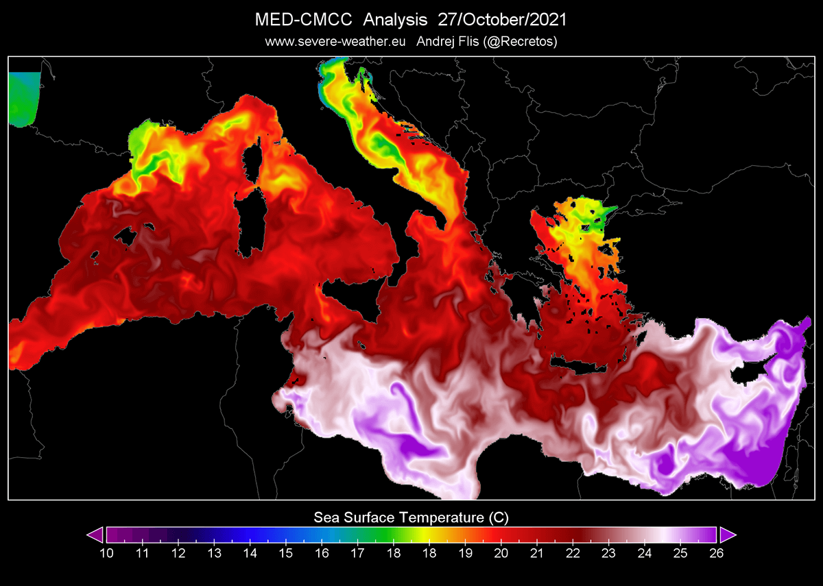
Temperatures are there even higher than 26 °C this week (about 4-5 °C above normal), so more than enough warmth to support the sub-tropical development when other conditions are met. Sea temperatures of 23-25 °C are also spread around Malta, Sicily, Greece. Very warm waters are also present in the southwestern Mediterranean.
These extremely warm sea waters in the southern portions of the Mediterranean Sea helped the formation of the first medicane of the season 2021/22 this week. Thanks to the weather pattern being relatively stable in the recent weeks, waters were kept very warm and fueled strong convective storms under the ongoing upper-level low.
MEDICANE IS LIKELY TO RE-INTENSIFY THROUGH FRIDAY INTO THE WEEKEND
Medicane is forecast to intensify again from Thursday through Friday and could bring additional rain and floods to Sicily, as well as around Malta. As the system deepens considerably, severe winds could also be another dangerous threat for the areas affected. The weather model forecast hints at a possible 150-300+ mm of additional rain in some areas until Saturday.
Attached below is a phase diagram, showing the birth of the medicane in the southern Mediterranean, near Malta and southeast of Sicily island this week. The recent model guidance suggests its center will make a gradual turn towards the northwest, potentially impacting both Malta and Sicily again.
![]()
![]()
The system will then likely recurve back east-southeast into much warmer waters after Friday and could become even more intense and organized once it comes closer to the coast of northern Libya over the weekend. Keep in mind that a more northerly solution is not out of the question either, making Sicily more vulnerable again.
From the chart here, we can see that the weather model hint at a definite symmetrical warm-core structure of the system once it gets back into shape between Malta/Sicily and the Libya coast.
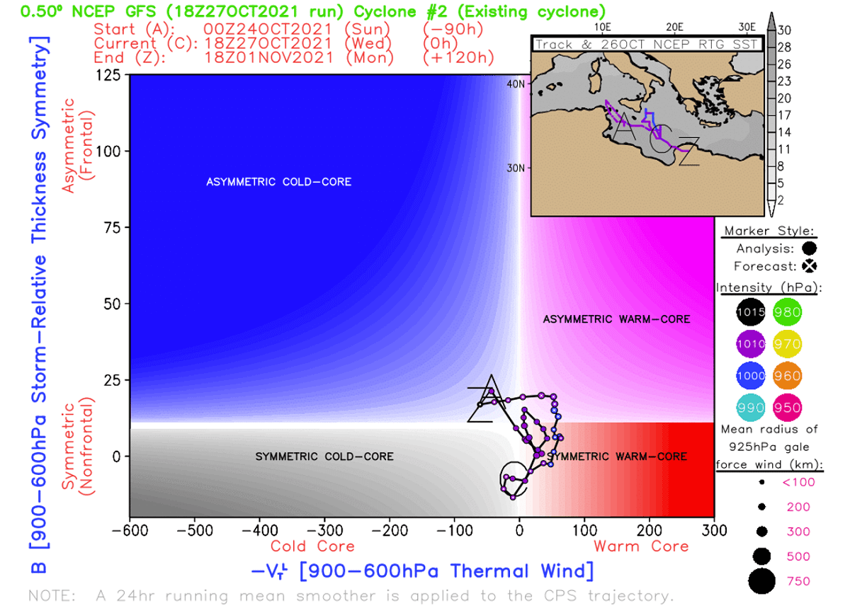
Now, despite the still some uncertainties regarding the intensity and the exact track of the cyclone’s center in the coming days, the general model consensus is impressively well-aligned medicane will become a strong one. The most robust charts are normally with the high-resolution weather models which can better define small systems like TLCs are.
Below is the comparison of the ECMWF, GFS, and ICON-EU weather model solution with all three weather models hinting at a deep low re-developing in the southern Mediterranean through the remainder of October. The ICON-EU model is being the most aggressive.
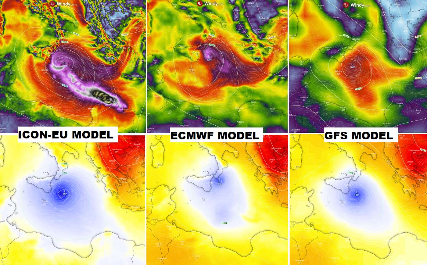
The general model agreement regarding cyclones’ position through Friday is rather good, but the track over the weekend is rather uncertain. The ECMWF model solution gradually vanishes the system while both GFS and ICON-EU model keeps pushing the medicate towards the southeast, reaching Libya coast through Saturday and Sunday.
The ICON-EU model develops even a pretty powerful medicane with potential damaging landfall to northeast Libya over the weekend. If this model verifies, the system would have hurricane-force wind strength.
Close monitoring of the developing dangerous weather situation needs to be considered by the locals in Sicily, Malta, as well as northern Libya. The gradual increase in confidence does suggest the Libyan coast could be affected, but the exact landfall area is still undefined.
POTENTIAL FOR EXTREME RAINFALL AND FLOODING IMPACT
Regardless of the time of occurrence and the exact position of the re-development of medicane, its impact could be severe for the coastal areas. Especially if it tracks closer or over Sicily which has been severely hit by destructive floods in recent days.
Once the cyclone re-intensifies, its track will be better defined and. Together with the threat of severe wind, also a high amount of rainfall is very likely to occur closer to the core of the low. How much rain and where indeed strongly depend on where the medicane will track.
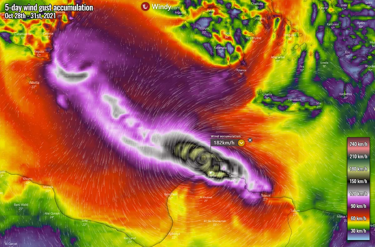
The intense convective storms could lead to several hundred millimeters of rain along its path, leading to significant flooding threats again.
Our team will be closely monitoring the evolution of the system and further updates might be required if necessary on Friday and Saturday when more weather model details and potential significant land threats will be better defined. Stay tuned.
***The images used in this article were provided by NOAA, and Windy.