Just days after an unseasonably cold, multi-day Arctic intrusion that perfectly aligned with the traditional mid-May “Ice Saints” period, a complete reversal of the synoptic regime over Europe is on the way. A record-challenging Heat Dome develops across much of the continent.
The European continent is bracing for a dramatic atmospheric turnaround as it transitions into the final two weeks of May.
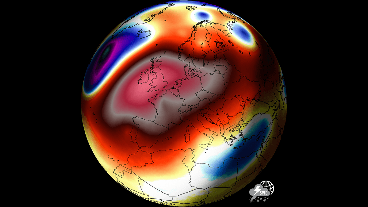
The driving force behind this pattern flip is a strengthening upper-level ridge building out of Northwest Africa and expanding across western and central Europe. This feature is evolving into a classic Heat Dome phenomenon where persistent high pressure acts as a thermal lid, trapping and continuously compressing subsiding air.
The evolution of the flipping weather pattern and the first taste of summer vibes can be seen in the animation below.
Parts of southwestern and western Europe are bracing for their first official “heat days” of the year. Temperatures in Spain and Portugal are forecast to surge into the mid- to upper 30s °C.
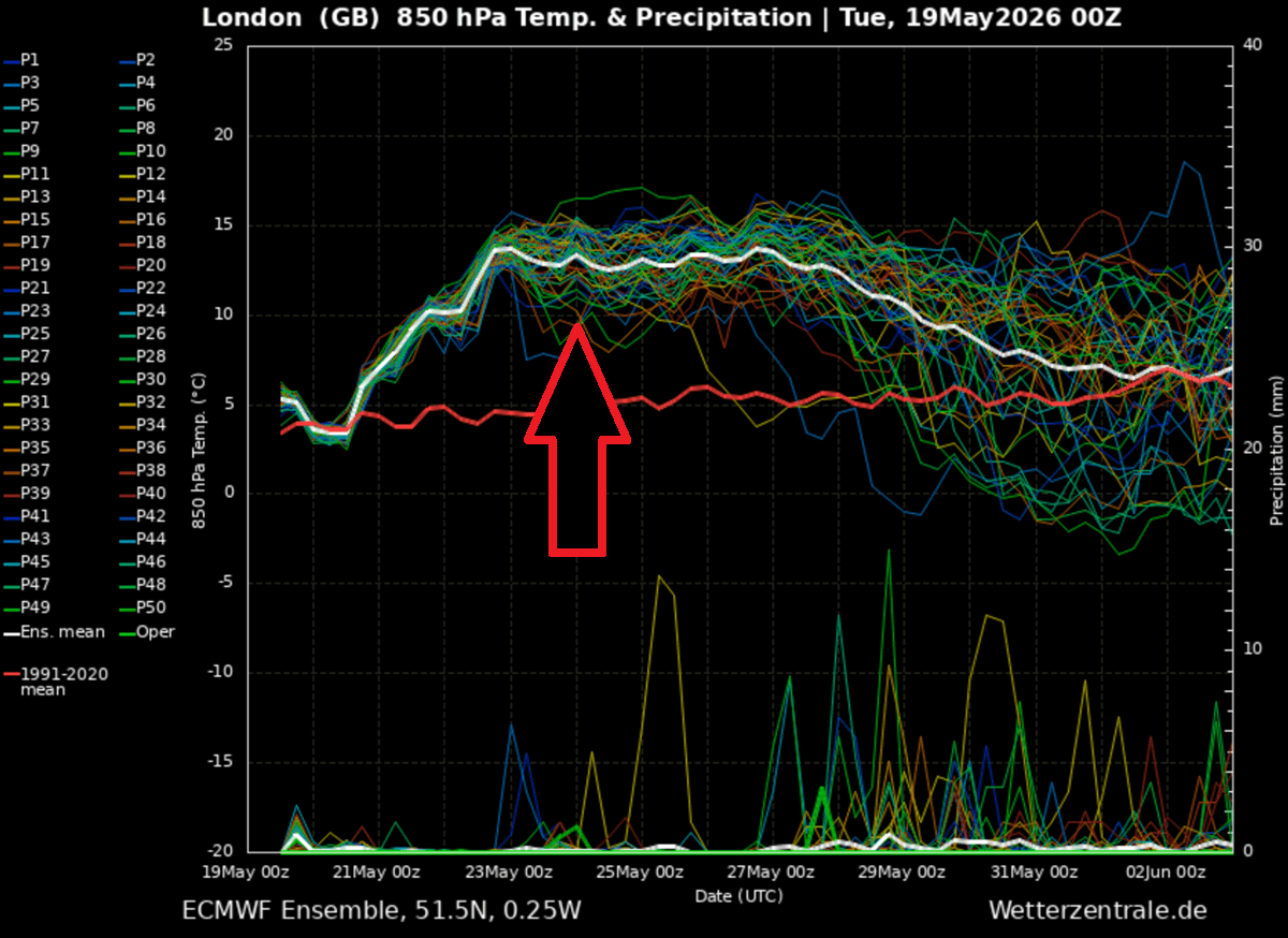
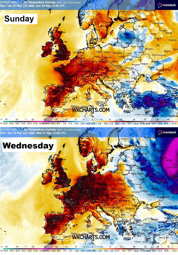
This surging warm air mass will gradually spread north and east, pushing afternoon highs into the mid- to upper-20s across most of western Europe, including the UK, France, and central Europe. Temperatures will be around 15 °C above the long-term average for late May, as shown in the meteogram below for London, UK.
Before we dig into the details about the pattern flip evolution in Europe, lets examine what is the main driver behind these extensive warm waves and heatwaves in general.
What is a Heat Dome?
When significant and historic record-breaking heatwaves occurred in Europe, the United States, and Canada in the past, the Heat Dome was a contributing factor. The heat dome is usually the dominant feature of summer weather patterns on both continents.
We refer to this phenomenon as a heat dome when extremely high temperatures develop. Here’s how it works and why understanding it on a broader scale is essential.
The upper-level ridge pattern, or very warm air mass in the higher altitudes, also known as the Upper High (or blocking High), usually forms the heat dome. This weather pattern brings high, and sometimes record-breaking, temperatures to the region below.
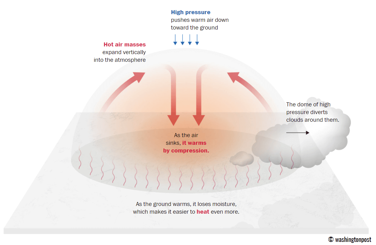
This term is used when a broad area of high-pressure air parks over a large portion of the continent. If the event is remarkably stable and extreme, it usually lasts several days or weeks.
The heat dome works like a lid on a pot. The extensive dome traps warm air at all levels underneath, with layers sinking toward the ground. Therefore, the air mass becomes anomalously warm at the lowest elevations and extremely hot near the surface.
How does a heat dome impact the life underneath?
Excessive heat in heat domes can significantly impact human health and be dangerous to particularly vulnerable populations, such as elderly individuals, children, and those with pre-existing health conditions that can be worsened by extreme heat.
Due to prolonged exposure to high temperatures, construction workers, farmers, and other outdoor workers who work long hours are at increased risk of heat-related illnesses. People living in poverty are also more susceptible to the fatalities of heat domes, as their houses are often built with heat-trapping surfaces such as concrete and asbestos.
Heat exhaustion occurs upon exposure to high temperatures for extended periods. It leads to dehydration, dizziness, and, in more severe cases, heat exhaustion can progress to heat stroke.
High relative humidity during a heatwave can also significantly affect the body. For this reason, we use a Heat Index to represent the natural feel of scorching hot temperatures and high humidity. It illustrates the natural relationship between temperature and humidity.
A record-challenging Heat Dome develops over Western Europe
The general weather picture over the North Atlantic and Europe is facing a dramatic flip, as the blocking High over the Atlantic collapses and a powerful warm plume develops from northwest Africa into southwestern and western Europe by the following weekend.
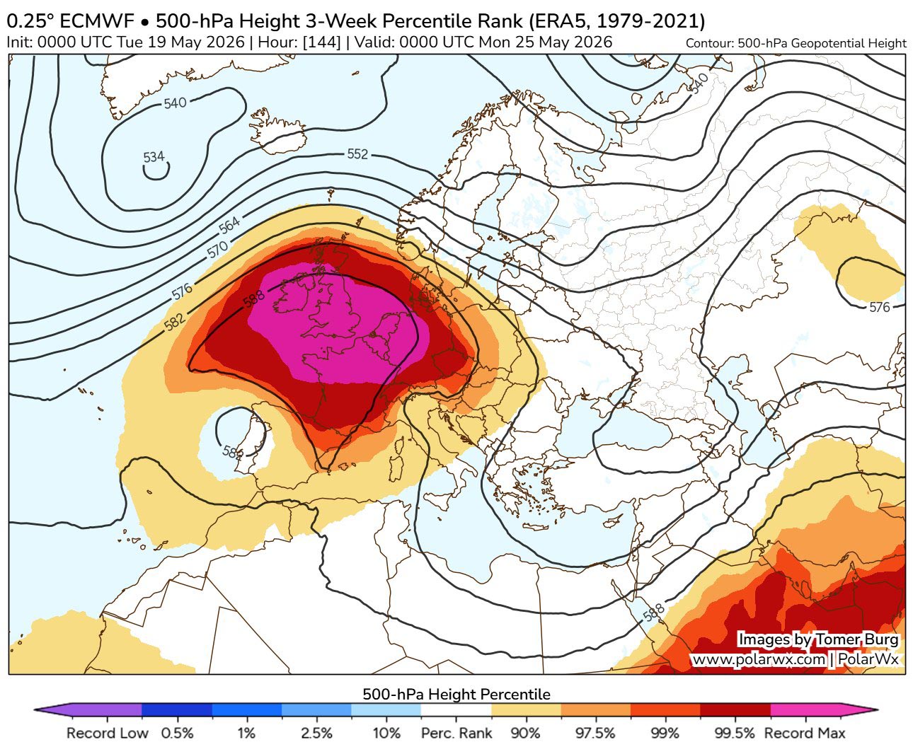
The extensive upper-level ridge will gradually expand further north and east, dominating most of the European continent throughout the remainder of May.
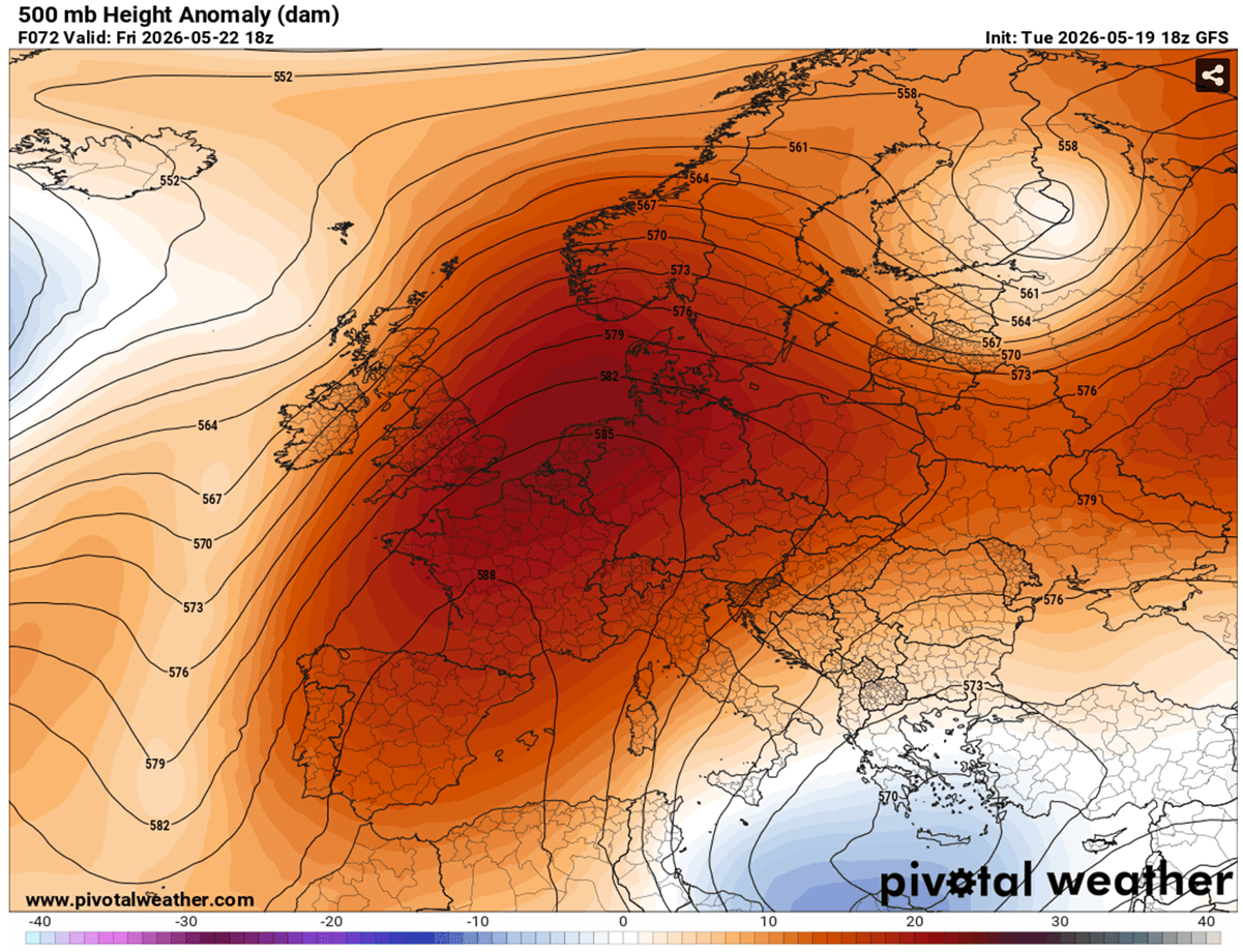
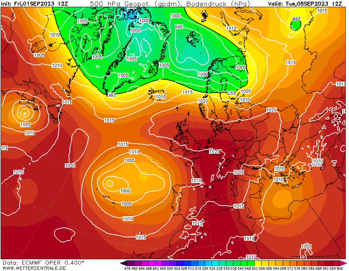
The medium-range ensemble guidance (ECMWF and GFS) indicates that the 500mbar geopotential heights could reach near-record levels for the month of May, climbing exceptionally high as the upper-level subtropical air mass expands.
These anomalous upper-level heights, paired with soaring 850mbar temperatures, represent a highly anomalous late-spring tropospheric setup. With the sinking air (compression and warming at the surface), it could reach the 30 °C threshold from Sunday through the early days of next week.
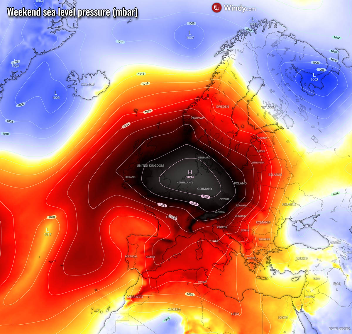
The sinking air within the heat dome also translates into rising pressure beneath, thereby developing a surface high-pressure system centered over Western and Central Europe for the weekend.
As the upper ridge expands over time, the surface high-pressure area will expand as well. It will bring well-above normal surface pressure for most of the continent, except for the far southeast and far north of Europe, where some upper waves will be traveling on the edge of the upper ridge.
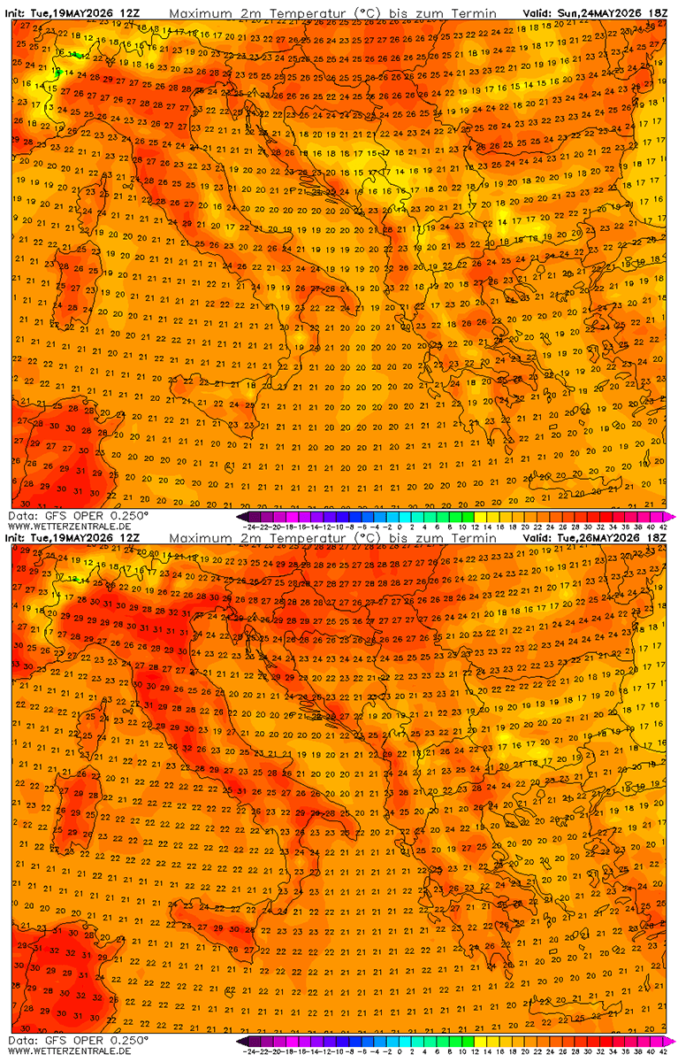
The significantly warmer air mass will gradually expand northward into the weekend, first across southwestern Europe on Thursday and Friday, then into western Europe by the weekend.
Until early next week, the warmest and most anomalous air masses will be over Spain, Portugal, France, Benelux, and the UK. They are expected to gradually spread further north and east by mid-next week.
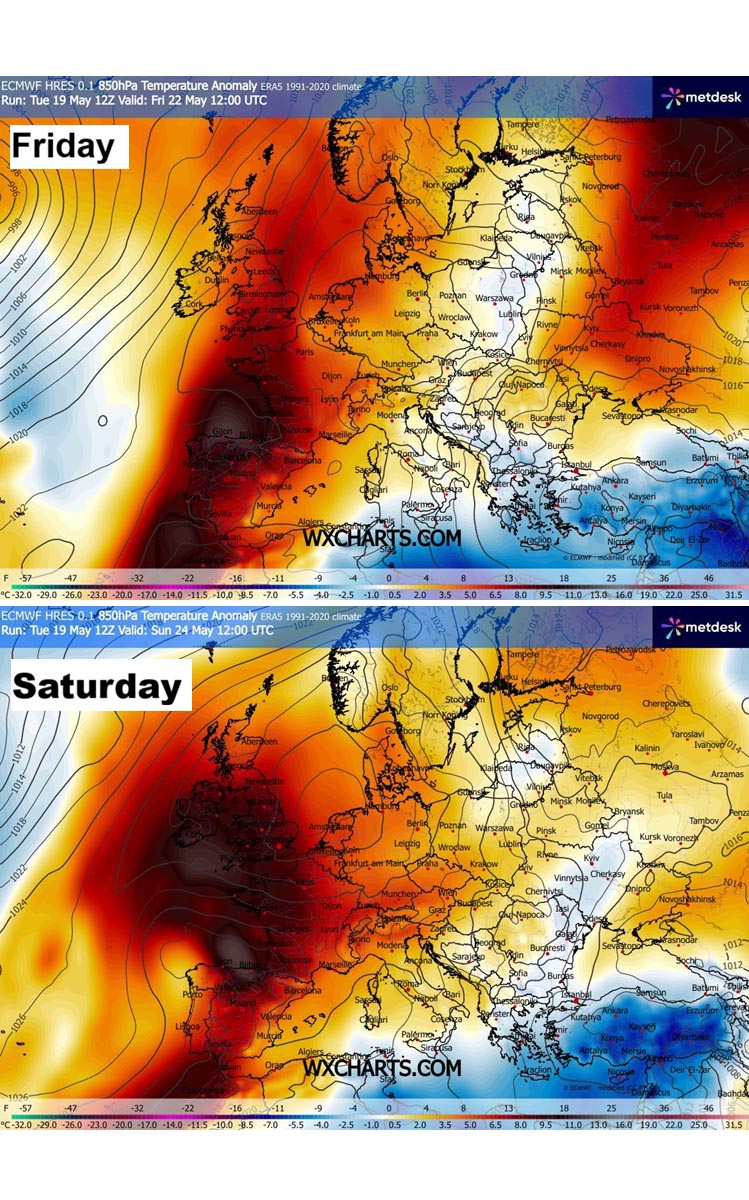
Near-surface temperature anomalies will already be strong across Spain and Portugal on Thursday, surging north into France on Friday and Saturday.
Temperatures will be into 12-16 °C above normals for late May, potentially even higher locally.
Therefore, daily highs will surge into the upper 20s to the low 30s in some regions.
The first heatwave of the season, with peaks into the upper-30s over Iberia, and to the low-30s for West-Central Europe
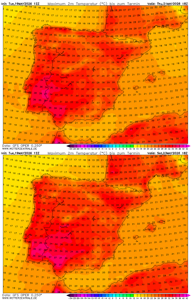
With the strengthening ridge aloft and an associated warm plume, temperatures will first start to climb significantly across southwestern Europe. They will reach mid-30s across south-central Portugal and south-southwestern Spain on Thursday, and continue on Friday.
The heatwave will then strengthen into the weekend, with daytime highs reaching the upper 30s on Saturday and Sunday over the southwest Iberian Peninsula.
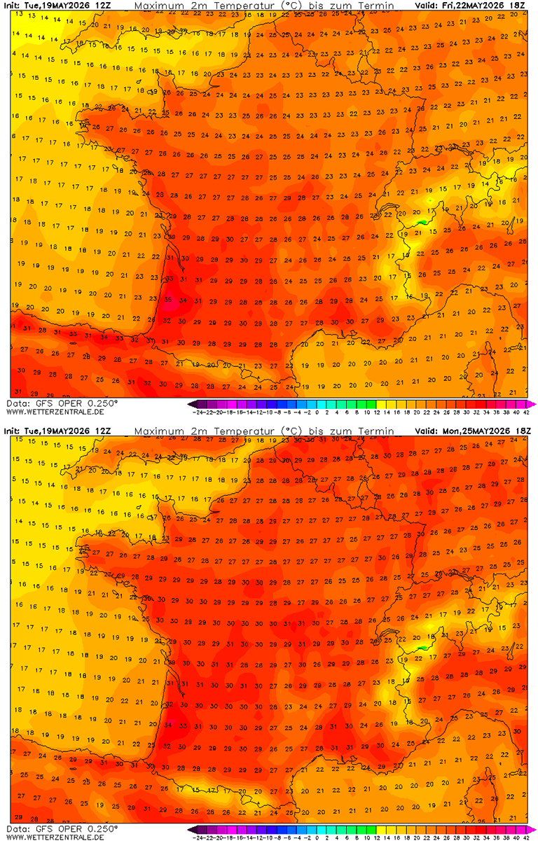
The significant warmth and heatwave starts over France on Friday, with peak daytime temperatures climbing into the upper 20s for most of the country and into the low to mid-30s for the southwest.
Warmth will also gradually expand into Germany and the Benelux as we head into the weekend. Temperatures could locally reach past the 30 °C threshold as well. First time this season.
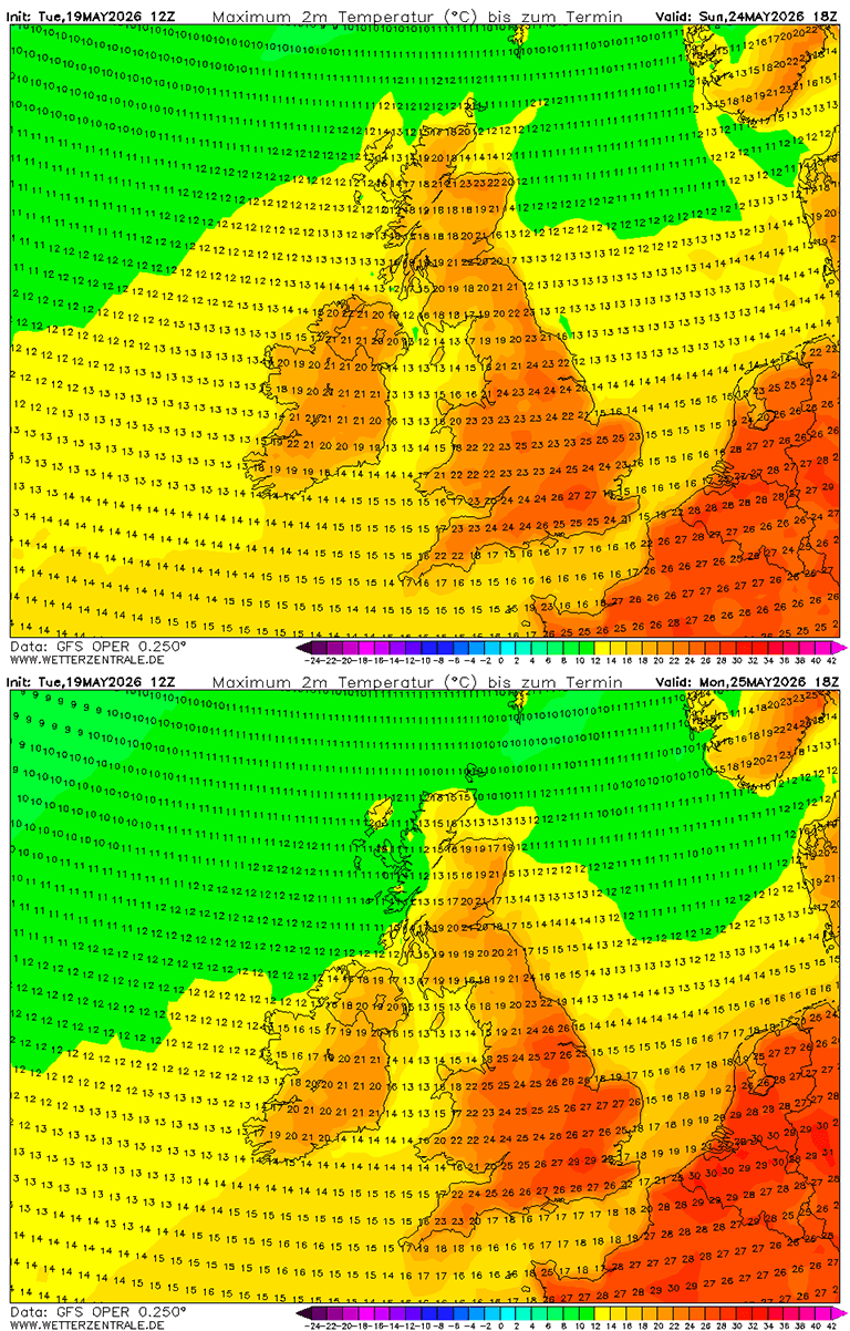
The British Isles will also experience an unusually hot days over the weekend into early next week, thanks to a powerful Heat Dome that parks over Western Europe.
This should allow the near-surface temperature to push near the 30s on Sunday and Monday. It will also be pretty warm over Ireland and Scotland, with low 20s forecast.
Temperatures will also gradually climb into the upper 20s to low 30s across the Mediterranean region, Italy, central Europe, and the Balkans from late weekend into the next week.
The highest temperatures will depend on how far east the upper blocking High expands after its mature stage over Western Europe on Sunday and Monday. Next week will remain unusually hot for late May, nonetheless.
We will be monitoring the ongoing significant pattern change and update the forecasts accordingly as the situation evolves over the weekend and early next week. Stay tuned.
Windy and WXcharts provided images used in this article.
See also:
How Will the 2026 Super El Niño Impact Summer Weather Patterns Across North America and Europe?