The summer heat blankets the Northern Hemisphere, bringing a spectacular display of nature’s fury – summer storms. These atmospheric phenomena, from towering thunderclouds to dramatic lightning strikes, captivate our senses. But for meteorologists and emergency managers, understanding and predicting these summer storms is vital for public safety. In this article, we delve into the power of weather radar during the summer storm season and explore how this remarkable technology helps us navigate the ever-changing weather patterns.
Summer storms are known for their intensity, frequency, and potential for severe weather events. From thunderstorms that unleash torrential downpours to supercells capable of spawning tornadoes, these weather systems demand accurate and timely forecasting. This is where weather radar plays a pivotal role.
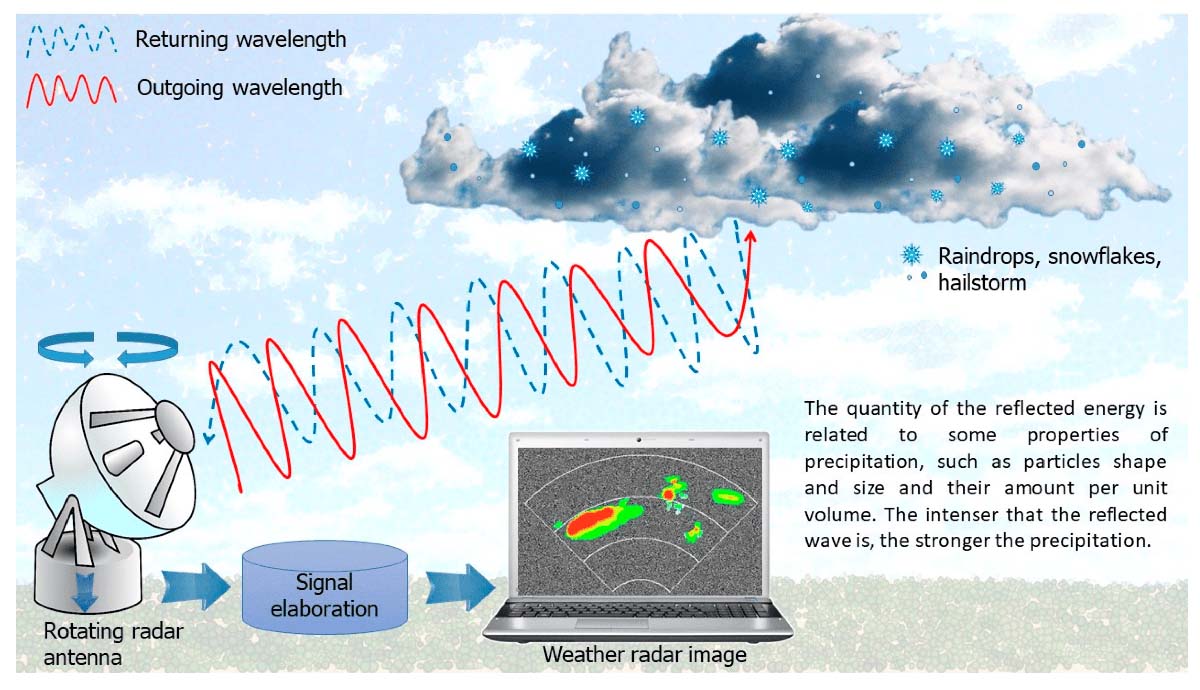
Weather radar, with its ability to detect and track precipitation, provides invaluable insights into summer storms’ structure, movement, and severity. By emitting radio waves into the atmosphere and analyzing the signals reflected by precipitation particles, radar systems unveil a wealth of information that aids meteorologists in their quest to understand and predict these dynamic weather systems.
UNDERSTANDING WEATHER RADAR
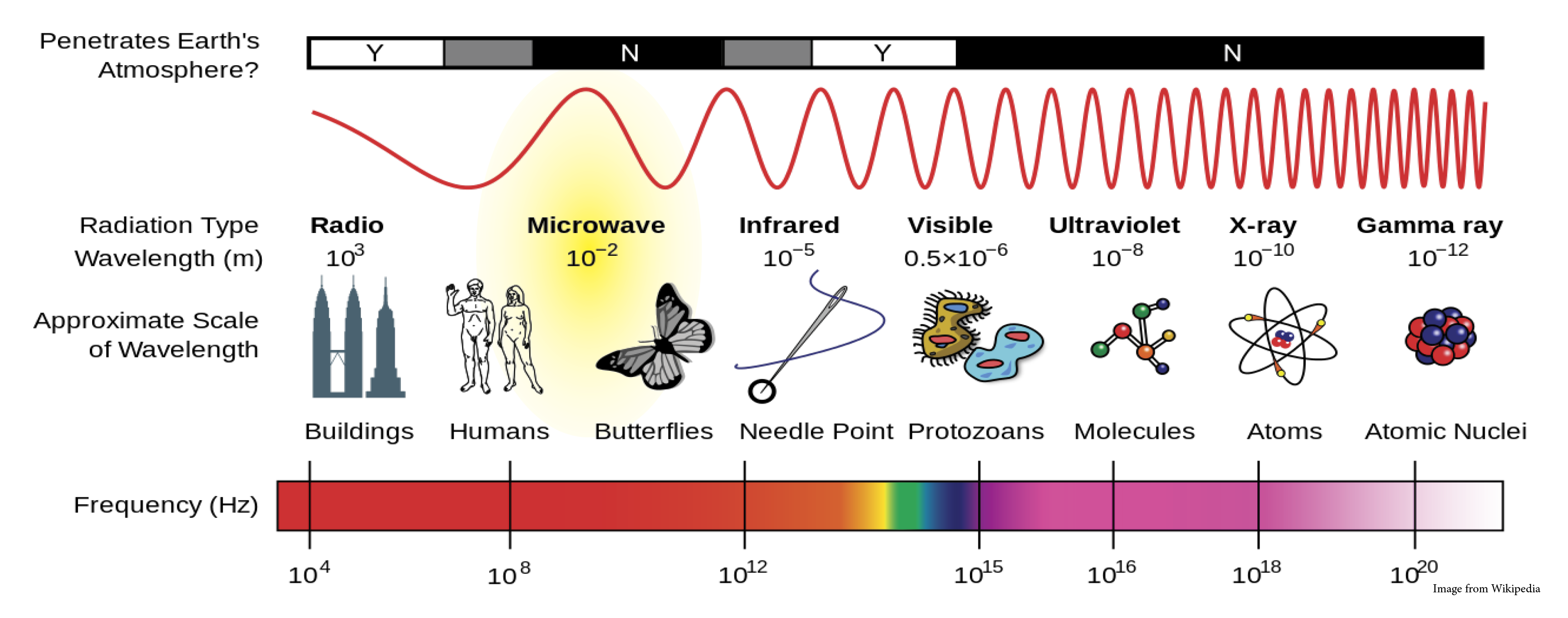
Understanding the intricacies of weather radar unveils a groundbreaking technology that utilizes radio waves to meticulously study precipitation, storms, and atmospheric phenomena. This innovation has fundamentally transformed meteorology by providing unparalleled insights into intricate weather patterns and significantly advancing the precision of weather forecasting. At its essence, weather radar functions by emitting energy pulses, often within the microwave frequency range. This range encompasses 4 GHz to 8 GHz in the C-band and 8 GHz to 12 GHz in the X-band. These emitted pulses interact with the atmosphere, particularly precipitation particles, initiating a remarkable process. As these pulses encounter particles, some of their energy is scattered and absorbed, while the rest rebounds as signals. Capturing and analyzing these returning signals enables meteorologists to extract critical data.
The insights derived from weather radar signals are nothing short of transformative. By evaluating the strength and characteristics of these returning signals, meteorologists can ascertain vital information, including the intensity, movement, and precipitation type.
Be it the gentle fall of rain, the graceful descent of snowflakes, or the tumultuous crash of hailstones, weather radar unveils the nature of atmospheric particles. Beyond precipitation, weather radar holds the potential to detect conditions conducive to tornadoes, helping communities receive early warnings and prepare for potential hazards.
Additionally, this technology grants a unique glimpse into the intricate structures of storms, enabling meteorologists to track their development, predict their trajectory, and enhance emergency response strategies. In essence, weather radar emerges not only as a scientific marvel but also as an essential tool in safeguarding lives, resources, and communities against the capricious forces of nature.
THE COMPONENTS OF WEATHER RADAR
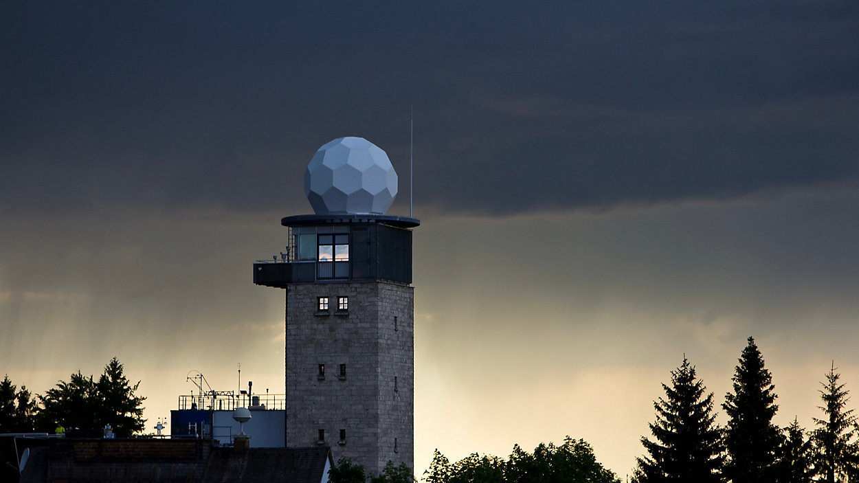
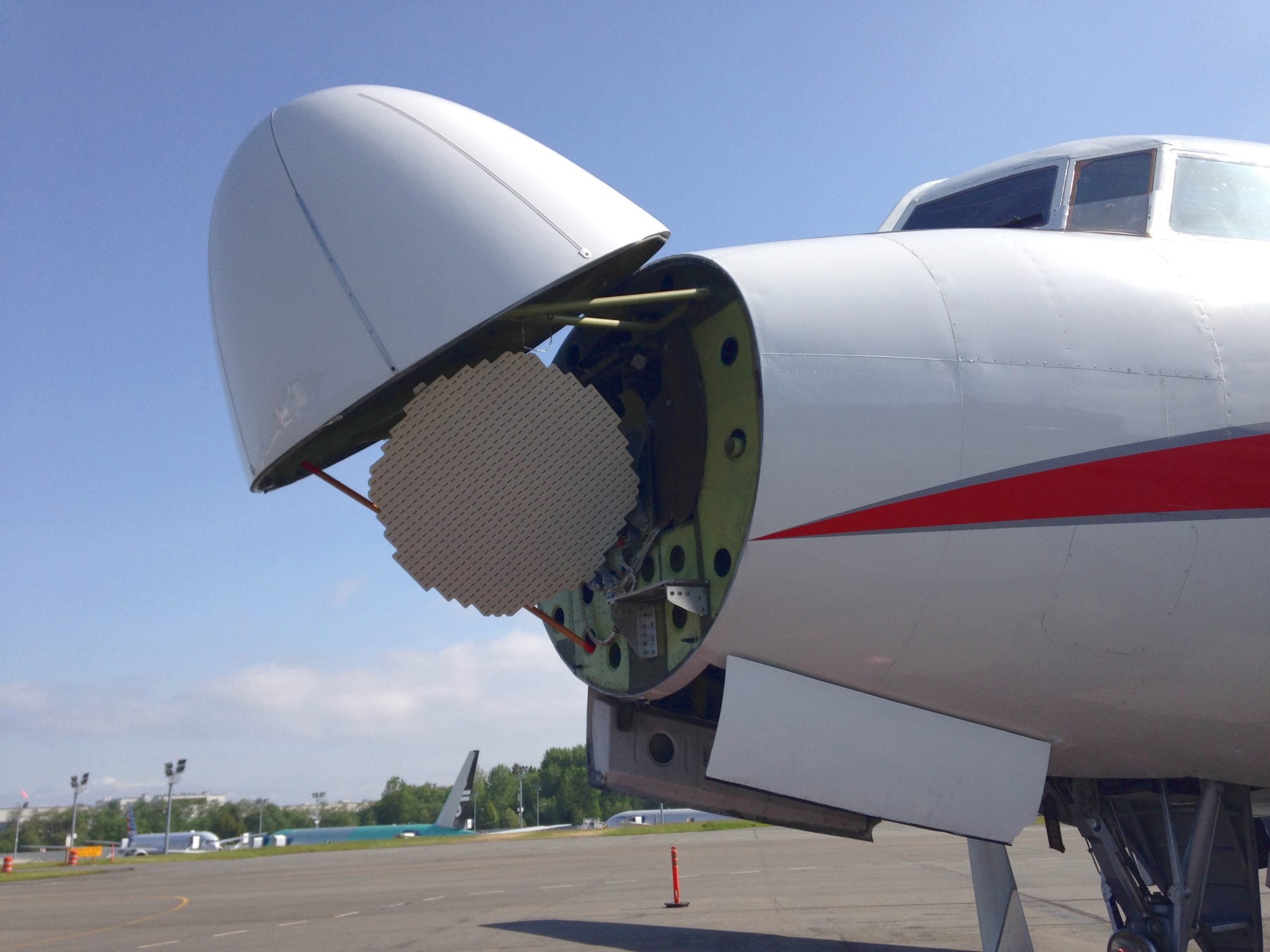
Weather radar systems have several essential components that combine seamlessly to gather, process, and present valuable data for meteorologists and weather forecasters. The transmitter is at the heart of a weather radar system, generating high-frequency radio waves emitted into the atmosphere. These radio waves are then transmitted through a specialized antenna.
The antenna, a crucial component, serves two primary functions: to radiate the transmitted energy into the atmosphere and to receive the signals reflected from precipitation particles. It is pivotal in determining the radar’s range, resolution, and beam characteristics.
Different radar systems employ various antenna designs, such as parabolic dish antennas or phased array antennas, each with advantages and capabilities.
Once the antenna receives the signals, they are passed on to the receiver, which amplifies and converts them into a usable form for further processing. The receiver enhances weak signals to ensure accurate and reliable measurements. It also incorporates filtering mechanisms to remove noise and interference that could affect the data quality.
The signal processor is a critical component that performs complex calculations and algorithms on the received signals. It handles tasks like range and velocity determination, data correction, and signal analysis. The processor transforms the raw radar data into meaningful information, such as precipitation intensity, storm motion, and other meteorological parameters.

Finally, the processed data is displayed on a monitor or screen, allowing meteorologists to interpret and analyze the information. The display component of a weather radar system provides visual representations of weather patterns; radar echoes, and storm characteristics. It enables meteorologists to track storms, identify severe weather features, and make informed decisions regarding weather forecasts and warnings.
THE DOPPLER EFFECT AND DOPPLER RADAR
The Doppler Effect, a fundamental principle of physics, lies at the core of Doppler radar technology, revolutionizing weather forecasting by enabling meteorologists to measure the motion of precipitation particles and extract valuable insights into wind patterns, storm rotation, and severe weather phenomena.
First described by Christian Doppler in 1842, the Doppler Effect refers to the change in frequency or wavelength of a wave as observed by an observer moving relative to the source of the wave. In the context of weather radar, the Doppler Effect manifests itself in frequency shifts in the radar’s emitted pulses of energy as they interact with moving precipitation particles.
By analyzing these frequency shifts, Doppler radar systems can determine the velocity at which precipitation particles move towards or away from the radar, providing meteorologists with invaluable information about the speed and direction of winds within storms. This capability allows for identifying storm rotation, a crucial factor in predicting tornadoes and other severe weather events. Doppler radar can also assist in monitoring mesocyclones, which are rotating updrafts within thunderstorms that may indicate the potential for tornado development.
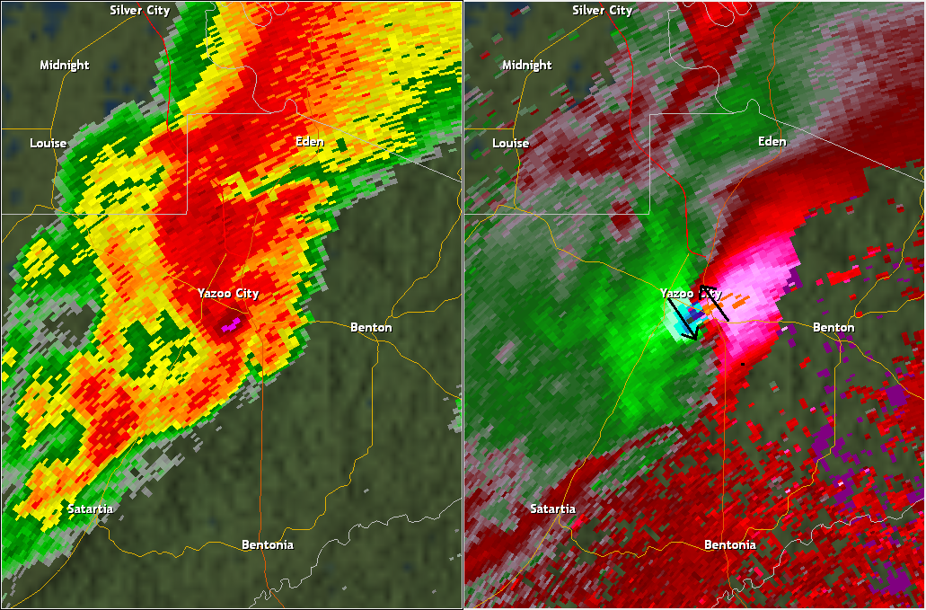
To implement the Doppler Effect in weather radar, specialized techniques are employed. One such technique is called pulse-Doppler radar, where the radar system alternates between transmitting and receiving signals, effectively comparing the frequency of the transmitted pulse with the frequency of the returned echo. The difference in frequency, known as the Doppler shift, is directly related to the velocity of the precipitation particles.
Dual-polarization Doppler radar furthers the capabilities by transmitting and receiving the radio waves’ horizontal and vertical polarizations. This allows for a more comprehensive analysis of precipitation characteristics, such as the size, shape, and type of precipitation particles. It enhances the accuracy of rainfall estimates, helps differentiate between rain, snow, hail, and sleet, and aids in the identification of severe weather features.
APPLICATIONS AND BENEFITS OF WEATHER RADAR
Weather radar has many applications and benefits meteorologists, emergency managers, and the general public, revolutionizing how we monitor and understand the atmosphere. One of the key applications of weather radar is in weather forecasting, where radar data plays a crucial role in improving the accuracy and timeliness of predictions.
By providing real-time information on precipitation patterns, storm movement, and intensity, weather radar enables meteorologists to track the development and progression of weather systems, aiding in issuing early warnings and preparing communities for severe weather events.
In the aviation industry, weather radar is critical in ensuring flight safety. Pilots rely on radar data to detect and avoid areas of intense precipitation, turbulence, and severe storms. By providing real-time updates on weather conditions along flight routes, weather radar helps pilots make informed decisions, leading to smoother and safer flights.
LIMITATIONS AND FUTURE DEVELOPMENTS
One of the limitations of weather radar is the curvature of the Earth, which affects the coverage and accuracy of radar observations. Radar beams typically travel in straight lines, but due to the Earth’s curvature, the radar beam gradually moves away from the surface as it travels farther from the radar site. This phenomenon is known as the “beam height increase.”
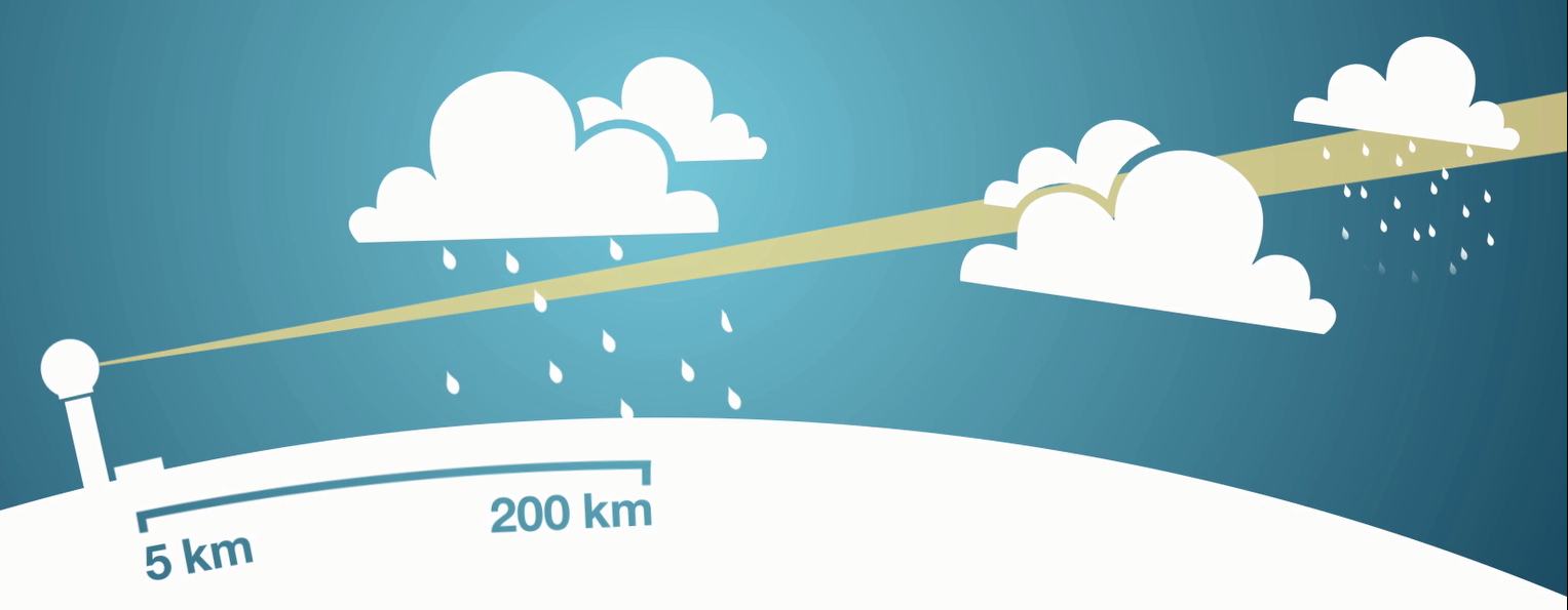
As the radar beam rises above the Earth’s surface, it encounters a larger volume of the atmosphere, which can lead to several challenges in weather radar observations. Here are a few limitations caused by the Earth’s curve and the straight beam concept:
Limited Range: The curvature of the Earth imposes a physical limitation on the range of a radar system. As the beam height increases, the radar signal gradually loses intensity and becomes weaker. Consequently, the radar’s effective range decreases as it attempts to detect and measure precipitation at greater distances from the radar site.
Beam Overshooting: When the radar beam is directed towards a storm or precipitation system that is relatively close to the radar site, the beam may overshoot the lower parts of the storm. This can result in a lack of detailed observations in the lower atmosphere, where important information about storm structure and intensity resides.
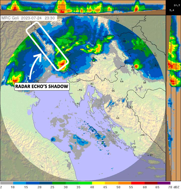
Radar Shadows: The Earth’s curvature can also cause radar shadows to form behind significant topographical features, such as mountains or hills. These radar shadows occur when the radar beam is obstructed by the terrain, preventing it from reaching areas beyond the obstacle. Consequently, radar coverage is limited in regions shielded by such terrain features.
Incomplete Vertical Sampling: The straight beam concept assumes a constant elevation angle as the radar beam travels from the radar site. However, the actual elevation angle gradually increases with distance due to the Earth’s curvature. This means that the vertical sampling of the atmosphere becomes uneven, with a greater focus on higher altitudes as the radar beam extends further from the radar site.
To mitigate these limitations, meteorologists and radar operators employ various strategies. They often use multiple radar sites strategically located to overlap coverage areas, allowing for more comprehensive observations. Additionally, specialized scanning strategies, such as volume and vertically pointing scans, are employed to gather data at different angles and improve vertical sampling.
In recent years, advancements in technology and the integration of data from multiple radar systems have helped address some of the challenges posed by the Earth’s curve and the straight beam concept. Dual-polarization radar and phased array radar systems offer improved capabilities for weather surveillance, allowing for more accurate and detailed observations, especially at longer ranges.

The future of weather radar holds the potential for enhanced coverage, improved data quality, and more precise and localized predictions. Researchers are exploring the use of new radar frequencies and polarizations, as well as deploying radar systems in innovative ways, such as on unmanned aerial vehicles (UAVs) or space-based platforms. These developments aim to expand radar capabilities, overcome current limitations, and provide a deeper understanding of our ever-changing atmosphere.
weather.gov, metoffice.co.uk, aviationtoday.com, bom.gov.au, vaisala.com, e-education.psu.edu provided images used in this article.
SEE ALSO: