The last three weeks have been something to remember across many parts of Europe – from extreme heat and wildfires in Spain, Italy, and Greece to record-breaking marine heatwave in the Mediterranean. Then, multiple destructive severe weather outbreaks with several tornadoes, a new European hailstone record, to windstorms followed, ending with historic floods in Slovenia. Storm Peter brought a significant cold refreshment this weekend, but the pattern will soon warm up again. A new scorching heatwave is expanding into southwestern Europe, spreading north and east through mid-August.
Over the weekend, finally, some much-needed relief in the heat came with the significantly cooler mixed maritime air mass associated with storm Peter moving into northern Europe. The recent severe weather outbreaks across south-central Europe have ended with a historic and destructive flooding event in Slovenia.
Meanwhile, the Iberian peninsula is overheating again. In response to a strengthening upper-level blocking High from northwestern Africa, a plume of hot air mass has been spreading into Spain and Portugal over the weekend. Over the coming days, the heat will intensify into mid-40s daytime maximum temperatures, with heat gradually spreading across western Europe later this week.

Towards the next weekend, the heatwave is forecast to gradually expand east across southern Europe, the Mediterranean region, central Europe, and the Balkan peninsula. How intense the heat will be in these regions is yet to be determined as the pattern evolves this week. Hot temperatures are forecast to return to Italy and Greece towards mid-August.
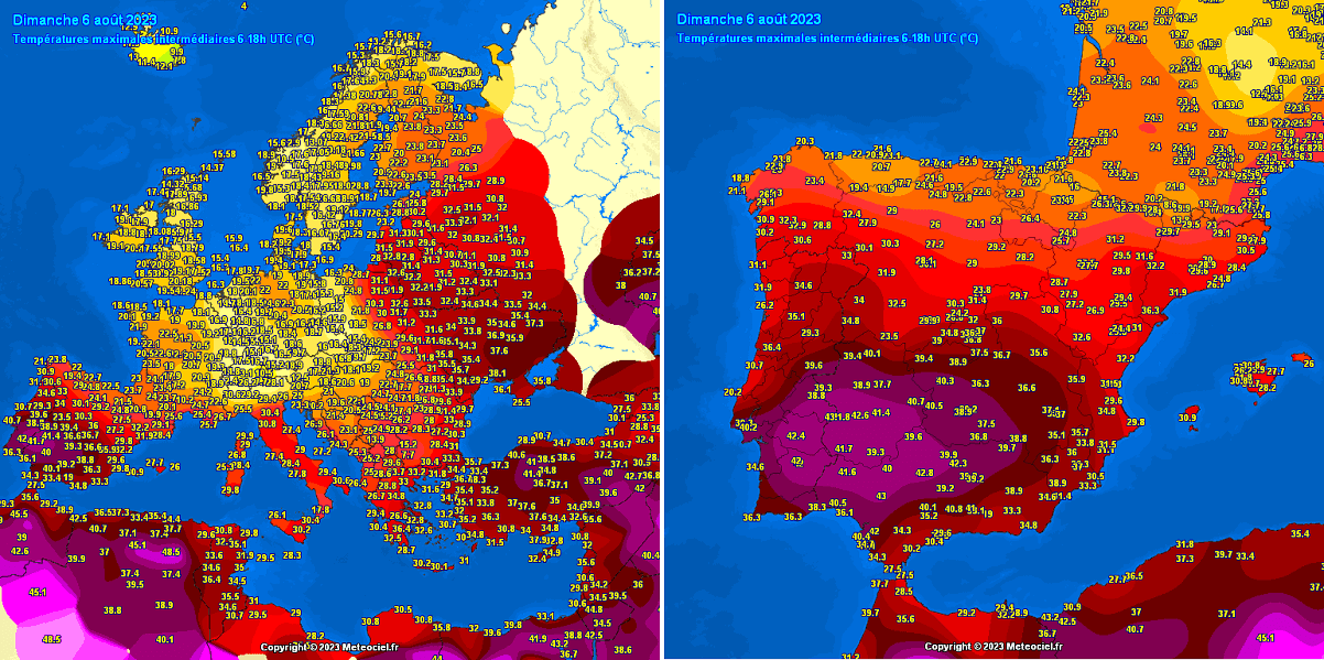
The heat has been significantly intensifying across Spain and Portugal on Saturday and Sunday. Daytime temperatures have pushed into +41 to +43 °C in both countries. Farther east and north, lower temperatures are observed as a cool maritime air mass is forecast to remain for a few more days before Peter finally vanishes.
With Monday, temperatures are forecast to climb into the low to mid-40 °C across parts of Spain and southern Portugal again, expected to continue in this range through mid-week days. Temperatures are also forecast to rise gradually over France and the Mediterranean in the following days.
We prepared the temperature anomaly over Europe animation below, indicating how significantly colder air mass is currently over northern and central Europe. At the same time, high contrast with much warmer temperatures is seen over the Iberian peninsula. Expansion of the heat is well seen throughout this week into mid-August.
A deep trough over Europe will remain until Tuesday when the upper High over southwestern Europe pushes north, and the low to the east diminishes. This will also help the temperatures to warm up again into France and the rest of Western Europe, including the UK, by mid-week. England will likely experience near 30s on Thursday, while significantly warmer weather will follow further south.
Generally, when we see a strong blocking High forming, a feature known as the heat dome intensifies heat waves; a specific weather pattern brings excessive heat and very high temperatures. Let’s talk about it first.
WHAT IS A HEAT DOME, AND WHY IT BRINGS EXTREME HEAT?
Let’s review the primary background cause of the intense heatwave in Europe this summer. We used the term heat dome when significant heatwave events occurred in the past, in Europe or the United States, and Canada. Usually, the heat dome is the main, dominant feature of summer weather patterns on both continents.
Heat dome will be the term we will use when extremely high temperature develops; here is why.
The upper-level ridge pattern, or very warm air mass in the higher altitudes, which we know as the Upper High or blocking High, usually forms the heat dome. This weather pattern often brings high, sometimes record-challenging temperatures for the region below. We use this specific term when a broad area of high-pressure parks over a large portion of the continent. It usually stays there for several consecutive days or even weeks.
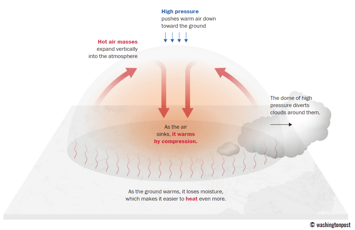
Explained in simple terms, the heat dome works like a lid on a pot. The extensive dome results in the trapping of a hot air mass at all levels underneath, with sinking layers toward the ground. Air mass becomes anomalously warm at the lowest elevations. Thus it creates very stable weather and often arid air mass with minimal chances for precipitation or even clouds—the sinking air parcels in the center of the heat dome result in rising temperatures.
Typically, warmer and drier weather produces a significantly enhanced wildfire threat due to developing drought or worsening the ongoing, pre-existing, arid conditions. Heat dome is often also to blame for being responsible for deadly heatwaves worldwide.
Thus, the daily average and maximum temperatures under the heat dome are typically above average. When the dome is particularly strong, it could often challenge or break existing historical records. Mainly if this feature develops during early summer or early autumn/fall.
COLD WAVE OVER CENTRAL PART OF CONTINENT FIRST, WITH BLOCKING HIGH AND HEATWAVE GRADUALLY RE-STRENGTHENS INTO WESTERN HALF OF EUROPE
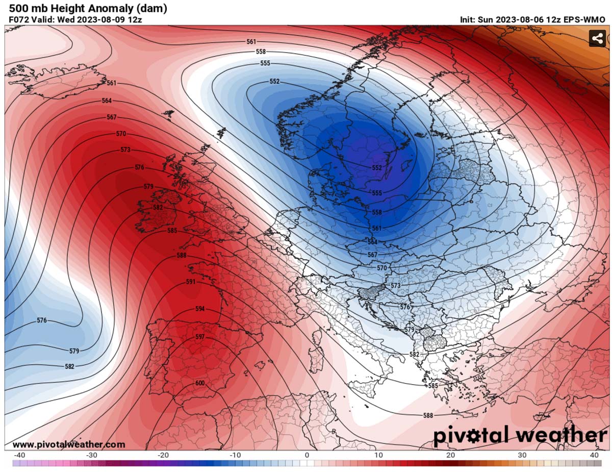
On Sunday, the general weather situation over Europe indicated a deep upper trough/low over central and northern Europe, with unsettled weather and cool maritime air mass from Benelux and Germany to the Alpine region, northern Mediterranean, and the Balkan peninsula. On the west, an upper High is strengthening over Iberia and further west.
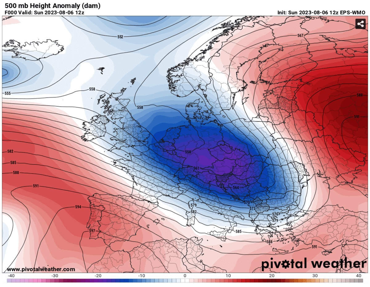
Strong northwesterly flow is seen between both large-scale features, suggesting a powerful jet stream is rounding th deep through. Cold air mass has overspread central parts of the continent, while the warmth has been re-emerging in southwestern Europe.
A warm air mass spread far north into Scandinavia ahead of the frontal system. Peter will bring severe weather and a lot of rain to Sweden on Monday.
Towards Wednesday, a deep low will finally lose its strength while gradually shifting north onto Scandinavia. Therefore, the blocking High on the west will expand north and east, developing a strong heat dome aloft. This will allow temperatures to return into more near-normal for August again.
The low is forecast to diminish further on Thursday when it moves east.
Temperatures continue to climb across Western Europe, Central Europe, and the Mediterranean. This pattern and southerly flow favor a significant temperature increase across the Iberian Peninsula after Monday and gradually over France after Tuesday.
As we see, the cold weather over central Europe vanishes, with temperatures returning to normal on Wednesday and Thursday before it should eventually warm up further into the next weekend.

By judging the positions of the High and Low on the 500 mbar chart above, we can hint that the pattern establishes a significantly warmer southerly flow from northwestern Africa into southwestern Europe once again.
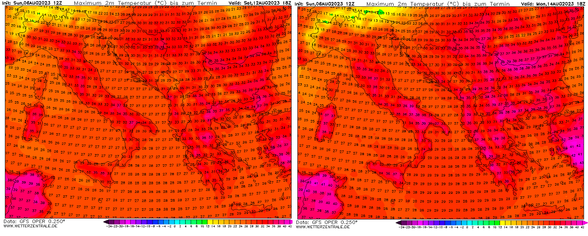
SCORCHING HEATWAVE RE-INTENSIFIES INTO SPAIN AND PORTUGAL, FORECAST TO REACH MID 40s AGAIN FOR MULTIPLE DAYS
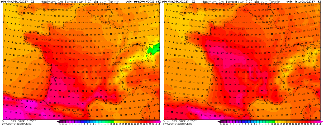
As usual in this pattern, the first regions affected will be the far southwestern Mediterranean and the Iberian peninsula. On Monday, the temperature will push into the 42-45 °C range over southern Portugal and southwestern Spain. Similar conditions will follow on Tuesday, while temperatures will remain in the upper 30s on the northern parts of the peninsula.
Then, on Wednesday, a strengthening of the heat dome aloft will allow temperatures to warm up significantly over much of the Iberian peninsula. Spain and Portugal are forecast to see temperatures above +40 °C in many regions, with the highest over southern and central Spain.

Wednesday could bring peak afternoon temperatures past +45 °C in Spain—Portugal in the low 40s.
On Thursday, refreshments will spread from the Atlantic and the Bay of Biscay into northwestern portions of the peninsula, bringing temperatures down off the 40s again. However, the scorching heat up to +44 °C will continue in the south and east of Spain.
Friday should also bring similar conditions, with even lower temperatures in the north.
HEATWAVE OVER FRANCE STRENGTHENS ON WEDNESDAY, SPREADS NORTH ON THURSDAY
With the strengthening High above and heat expanding over the Iberian peninsula on Wednesday, hot weather will also expand into France. Wednesday should bring upper 30s over southern and southwestern parts, low to mid-30s over western France, and upper 20s in the north.
Then, on Thursday, the maritime air mass on the north will be finally pushed away as southern winds also return the heat into central and northern France. Peak temperatures should be above +35 °C across the bottom two-thirds of the country, just shy below the 30s on the north towards Benelux and the English Channel.
These two days will be the hottest for France this week so the heat will be a short breath in the country. Thanks to another disturbance with a cooler maritime air mass from the Atlantic for the second half of the week.
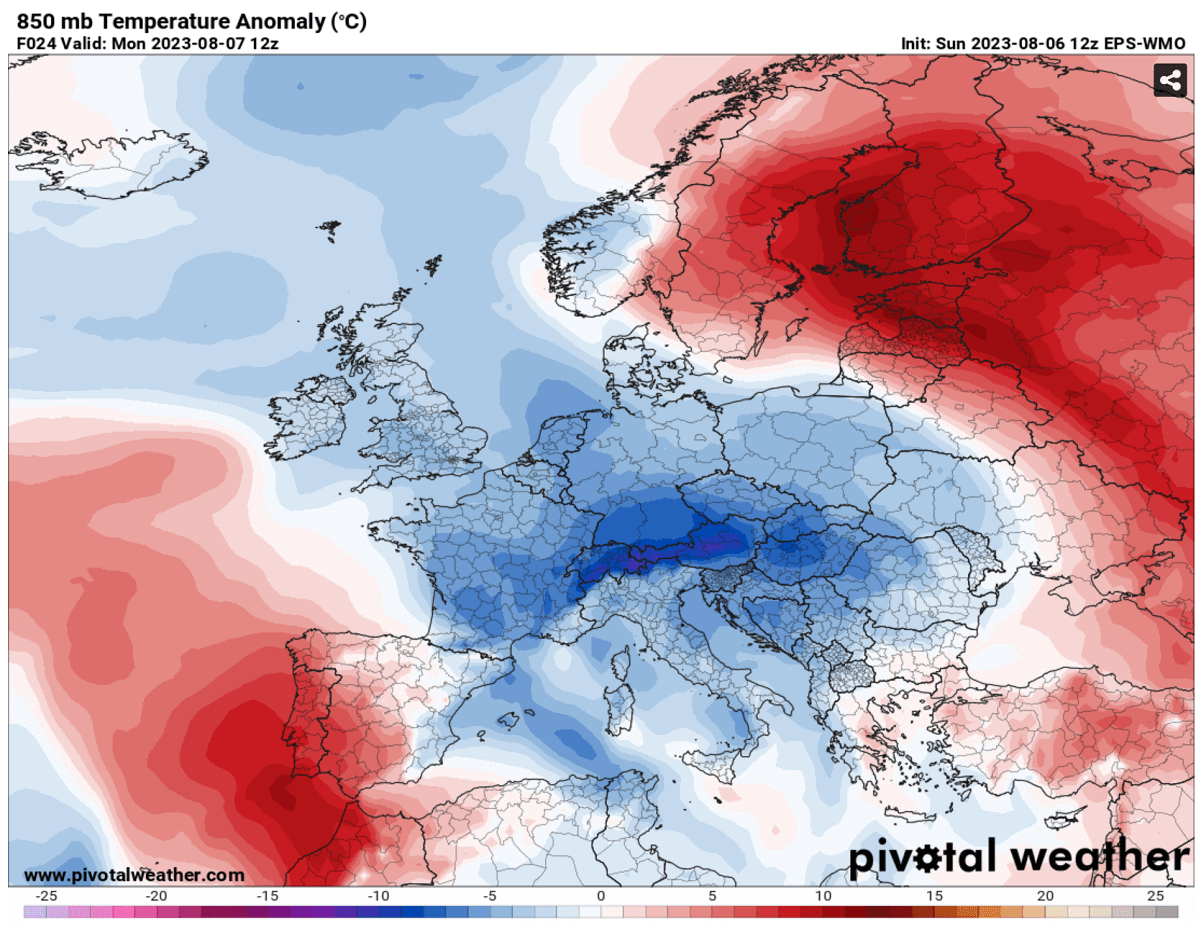
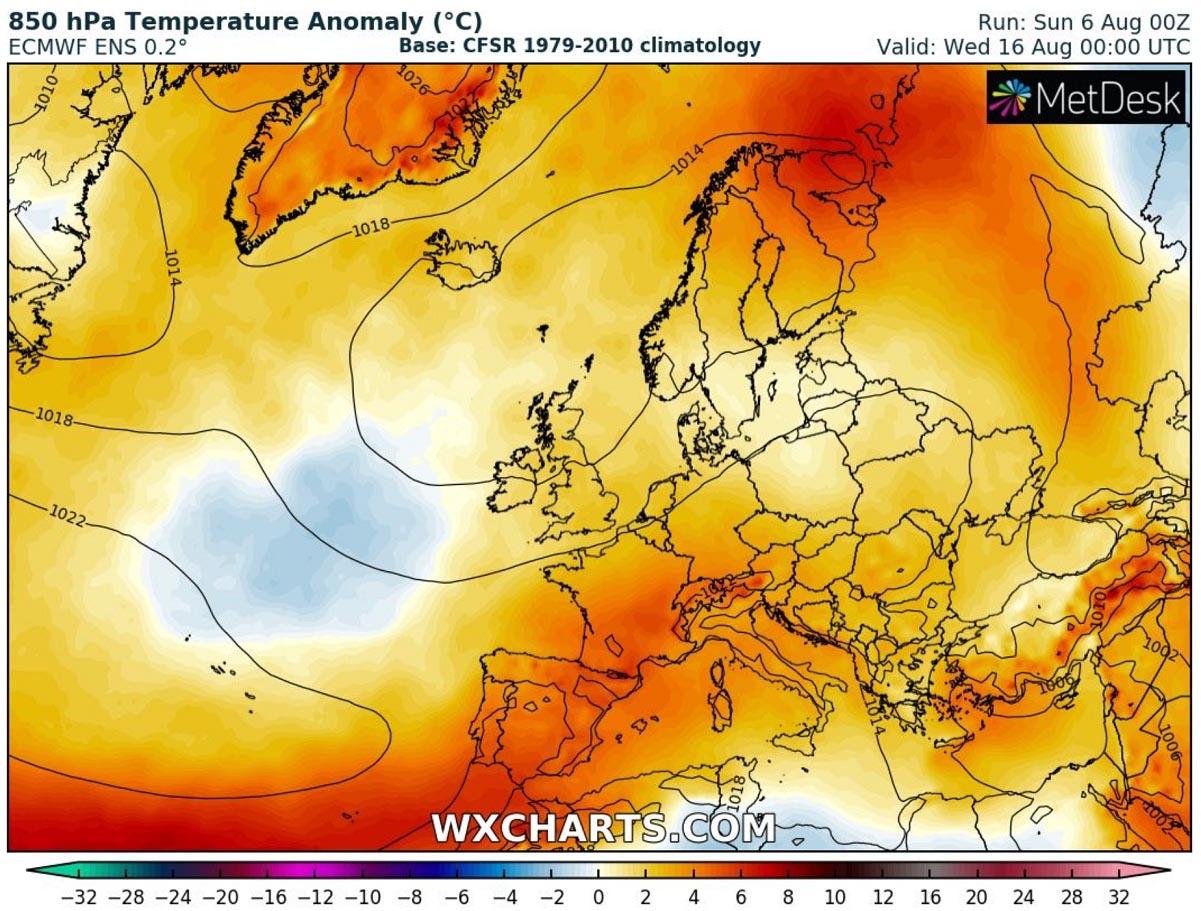
Attached below is Thursday’s 2m temperature anomaly over Europe. We can see how significantly anomalous the air mass from Spain to southern France, with warmer weather also for the rest of France, the UK, and Ireland.
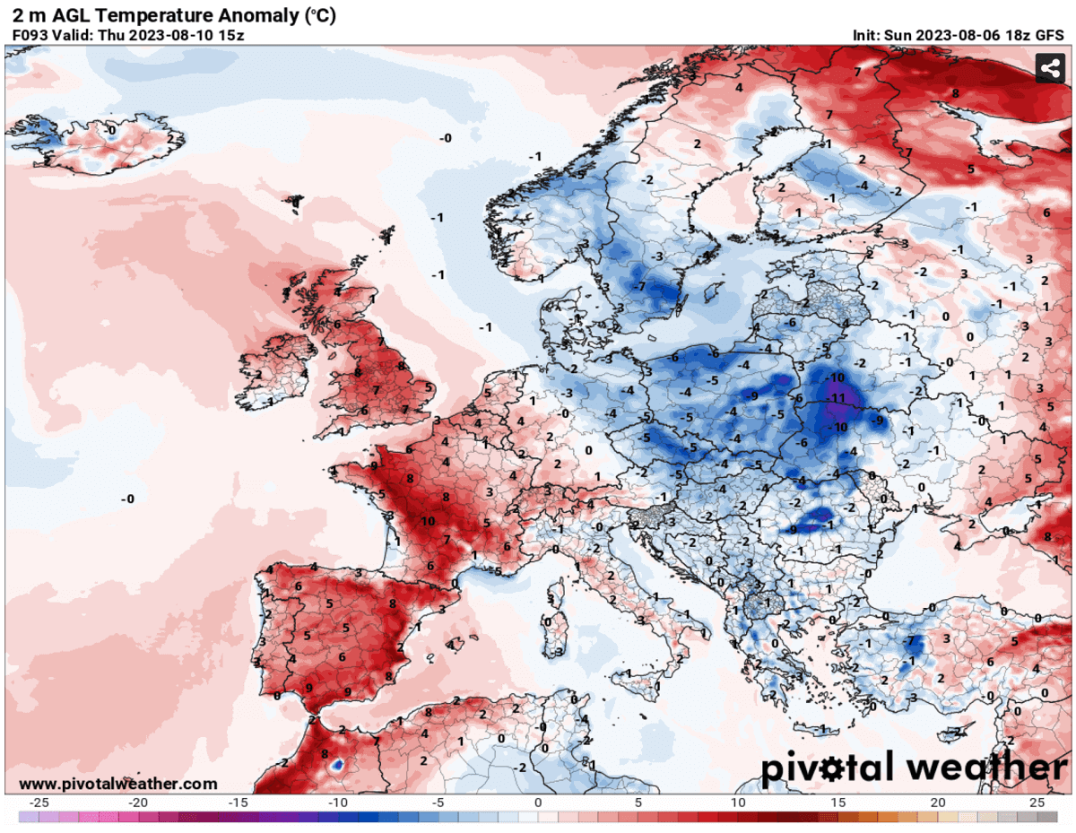
As we can see, most of Europe, with exceptions near the core of the vanishing storm Peter over southern Scandinavia and Denmark, will return to above-normal temperatures.
HEATWAVE ALSO EXPANDS FURTHER NORTH, REACHING THE UK THROUGH MID-LATE WEEK, PEAKS ON THURSDAY
So, as mentioned earlier, the strengthening heat dome results in the heatwave expansion north through mid-week, with scorching heat from Algeria and Morocco spread into Spain and Portugal. While France follows into much warmer weather on Wednesday and Thursday, UK and Ireland will also warm up significantly.
Especially if we consider the recent weeks where temperatures were unusually low for the summertime period, the reason behind this is the persistent flow from the Atlantic, with several depressions bringing a lot of rain and cool maritime air mass.
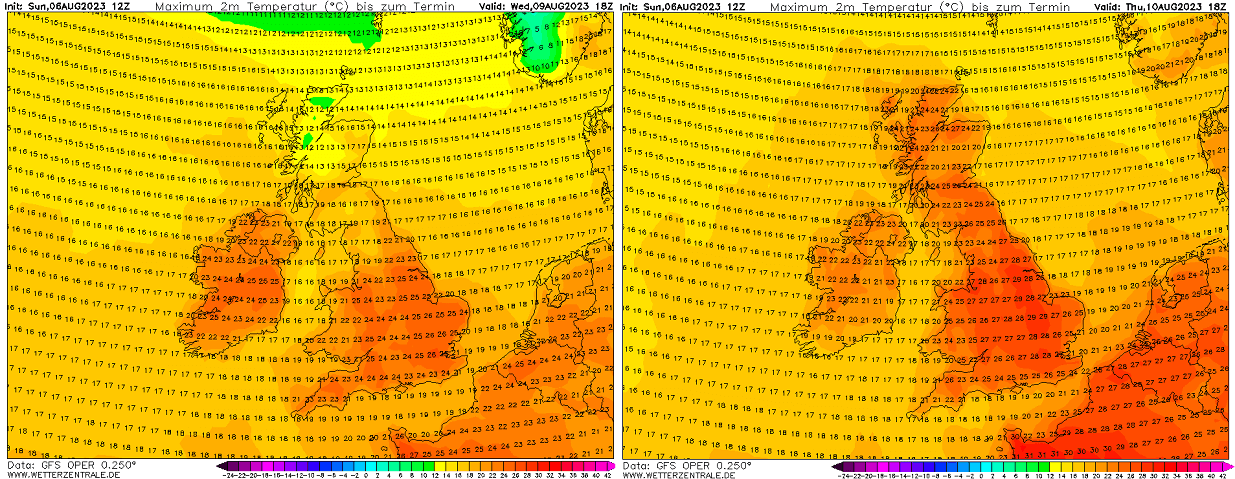
On Wednesday, temperatures are forecast to climb into around 25 °C over Ireland, 22-23 °C for Northern Ireland, similar for Wales. England should also see temperatures from 24 to 26 °C on Wednesday, while Scotland remains below 20s.
Warmer temperatures spread into England, Wales, and Scotland on Thursday, locally reaching close to 30 °C in central England. Ireland and North Ireland will see a tad lower temperatures on Thursday than the day before.
It will again become cooler on Friday and over the next weekend.
HEAT RETURNS TO THE MEDITERRANEAN, CENTRAL EUROPE, AND THE BALKAN PENINSULA NEXT WEEKEND
The Mediterranean region remains rather off the very hot weather until Thursday, as the upper High on the western doesn’t expand east often. But the next weekend, temperatures are forecast to push into the mid-30s over Italy and the Balkan peninsula.
Becoming even warmer on Sunday as higher temperatures aloft overspread southern Europe. Temperatures could again generally approach the upper 30s in Italy and across the southern Balkans.
Thus bringing Albania, Serbia, North Macedonia, Greece, Bulgaria, and Romania into 37-40 °C range again. Even higher temperatures are forecast over Turkey, into the low 40s across the west and central parts of the country.
COULD THE HEATWAVE EXTEND FURTHER THROUGH MID TO LATE AUGUST AS WELL?
We are looking over the general mid-range trends; there are hints that the heatwave will significantly strengthen and expand over much of Europe again. This is supported by the global weather models GFS and ECMWF, hinting at a potential development of a large heat dome over the European continent.
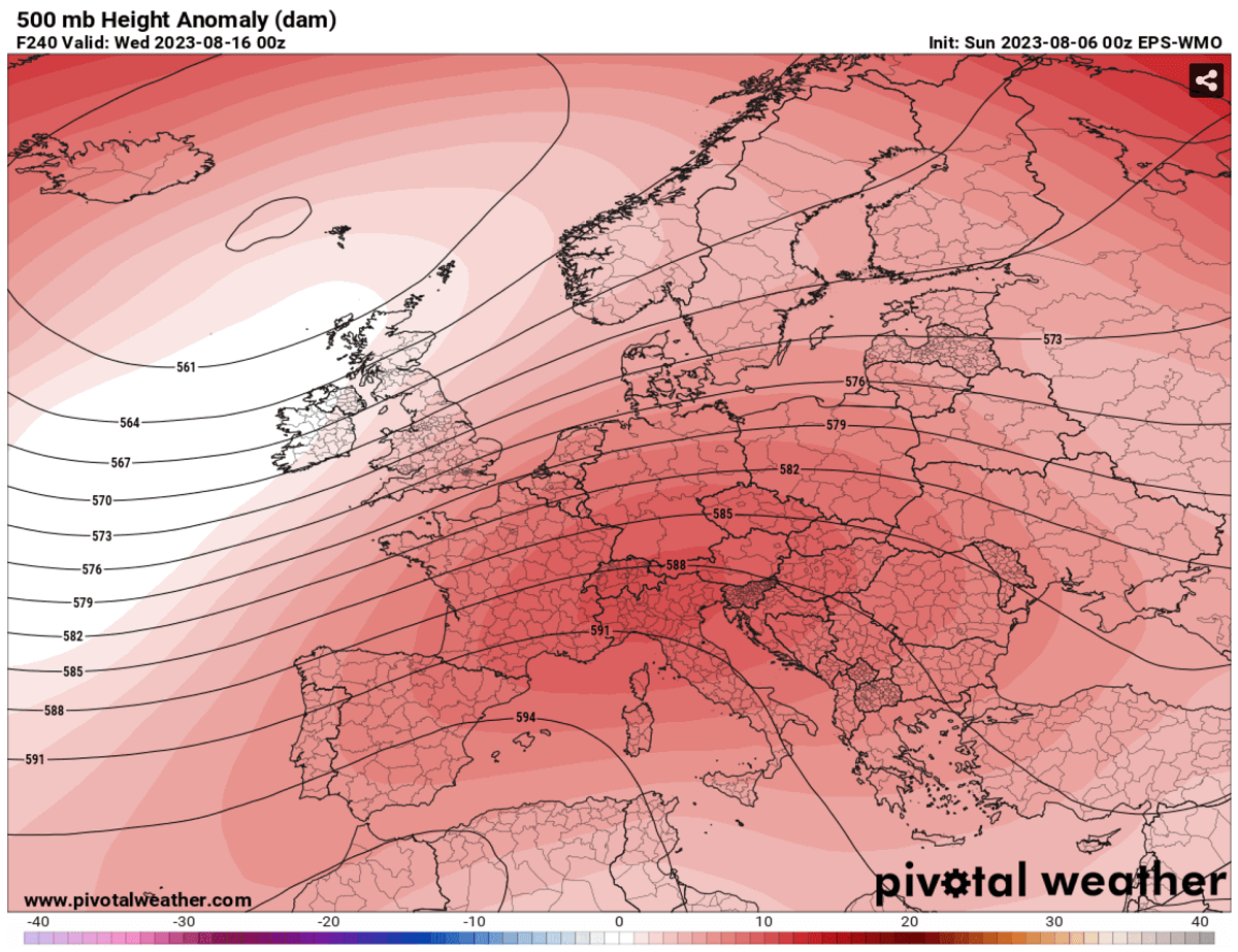
The pattern evolution after next weekend suggests low pressure will sit over the Atlantic, but higher geopotential heights could follow over Europe. The 500 mbar anomaly chart above hints at this evolution seen in the ECMWF EPS model.
How large and intense the anomaly will be regarding temperatures is still too far to determine. Still, both global models hint at the much warmer than normal weather across most of Europe for mid-August.
So, although it is still a week ahead of us, the general weather model consensus agrees that heat will remain over Europe further next week.
If this occurs, it will likely increase the potential of more severe weather outbreaks late this month. This is because the recent weather systems’ large amount of rain and soil moisture will allow air mass to remain humid and hot.
Thus supportive of a significant amount of energy available for the potential upcoming weather fronts in the following weeks. Conditions will be monitored closely once models hint at the more progressive pattern evolution and change.
Here is a great overview of the upcoming heatwave on the Meteogram charts. The upper left is for Sevilla, Spain; we have Toulouse, France, on the upper right and Dublin, Ireland, at the bottom.
The air mass over southern Spain remains above normal for the next 14 days, strongly anomalous this week as heatwave peaks. Southern France indicates a short heatwave peak on Wednesday and Thursday. While Ireland also has a relatively short warm period from Tuesday through Thursday.
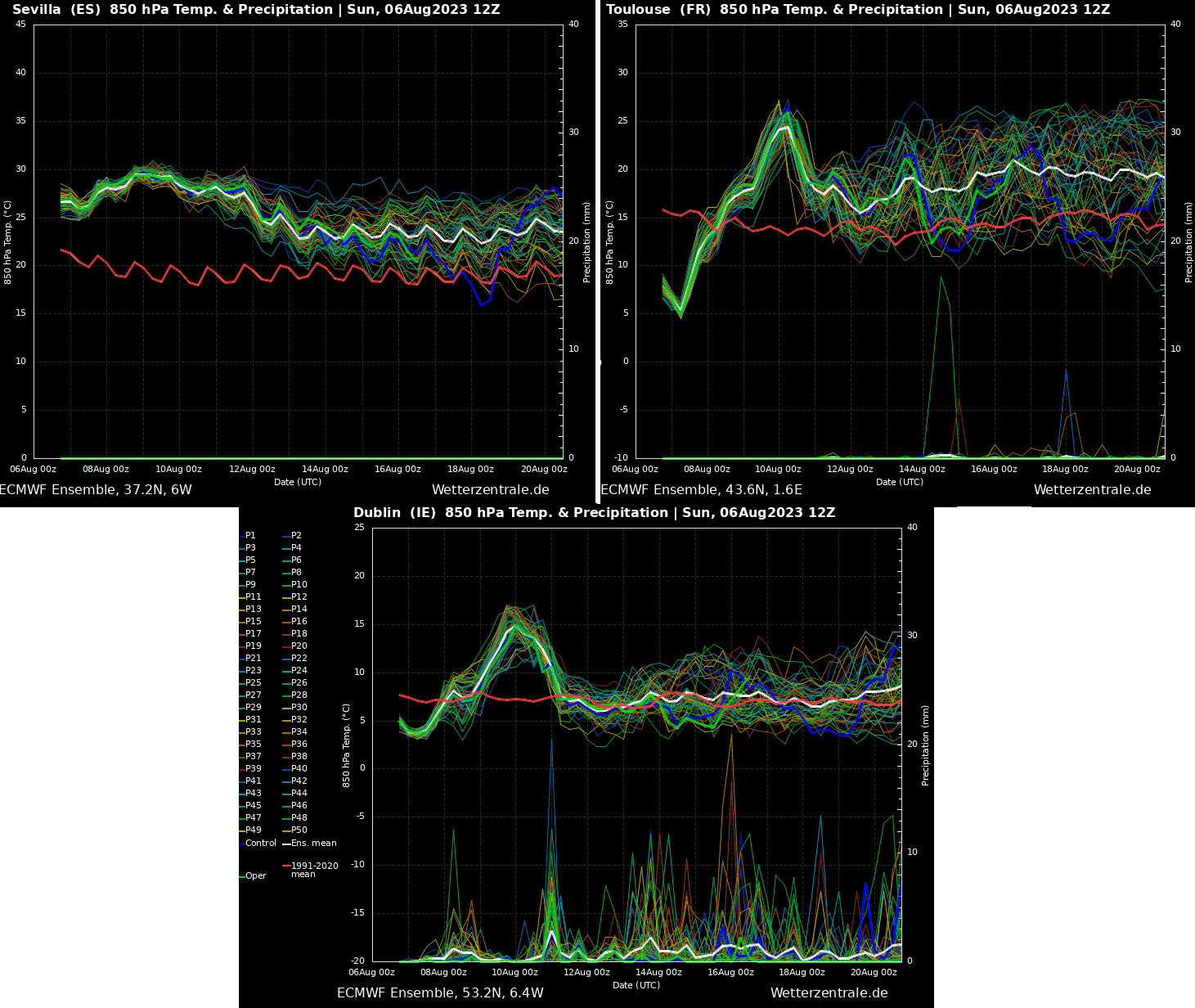
The Sevilla chart has 850 mbar level temperatures (approximately 1250m above the ground) close to 30 °C. This suggests that the peak temperatures near the ground would quickly push well above 40 °C approaching 45 °C in some areas. As discussed earlier, Toulouse reaches around 25 °C at this level, so the upper 30s are near the ground.
Dublin’s peak on Thursday is around 15 °C at this 850 mbar level, suggesting peak temperatures around 25°C will be possible.
HEALTH RISKS DURING A HEAT WAVE
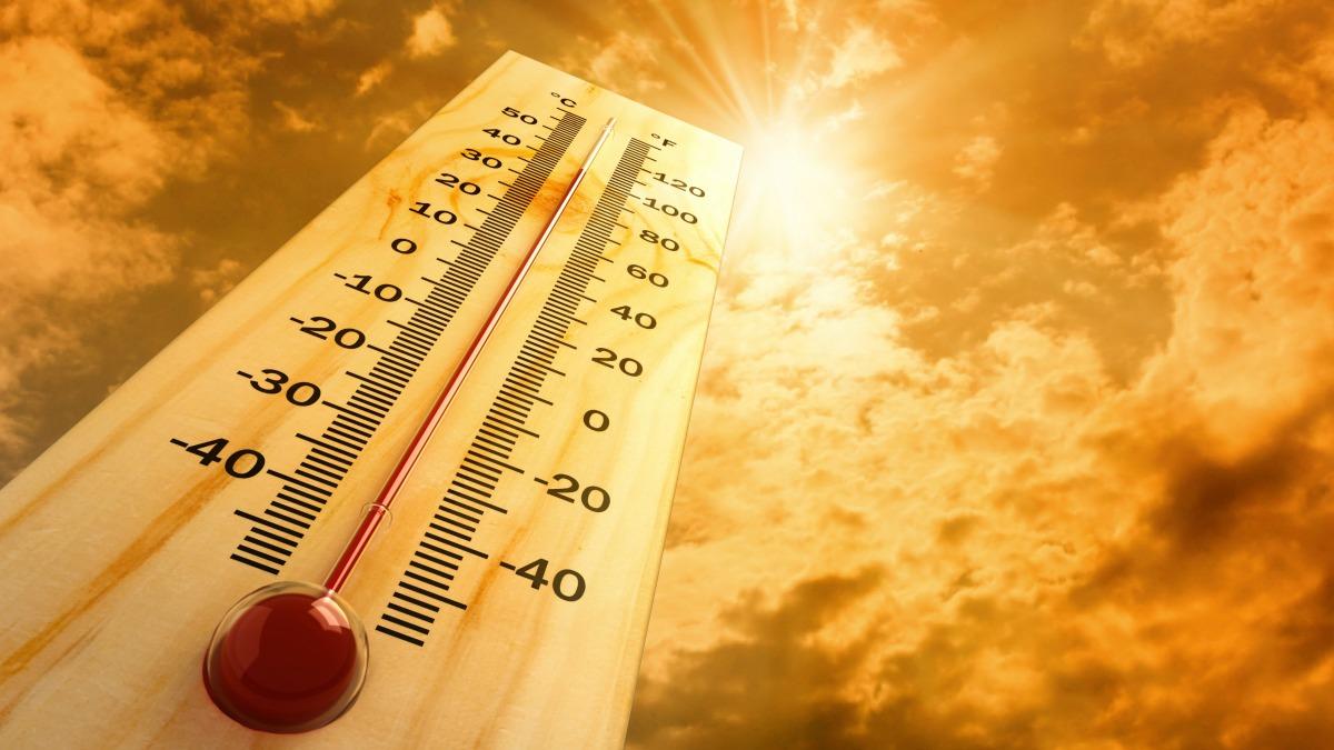
An extended period of hot weather, generally surpassing +35 °C but significantly above +40 °C, is physically challenging and presents an enhanced risk for health.
Sweltering weather, particularly in extended periods – heat waves – is uncomfortable but presents a significant health risk.
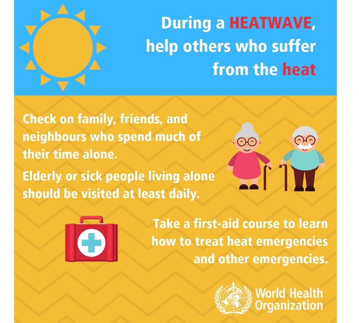
Who is most at risk?
Hot weather is uncomfortable to most of people, but the following groups are particularly threatened by the very high temperatures we encounter in the summer months:
- elderly people aged over 75 years
- babies, young children
- people with chronic/long-term health conditions, such as diabetes, respiratory disease, circulatory disease
- people who are obese
- people taking certain medicines
- people who work outdoors, in hot/poorly ventilated areas, or engage in physical activity in hot weather
- socially isolated people
- people who are not acclimatized to hot weather, such as tourists from northern countries
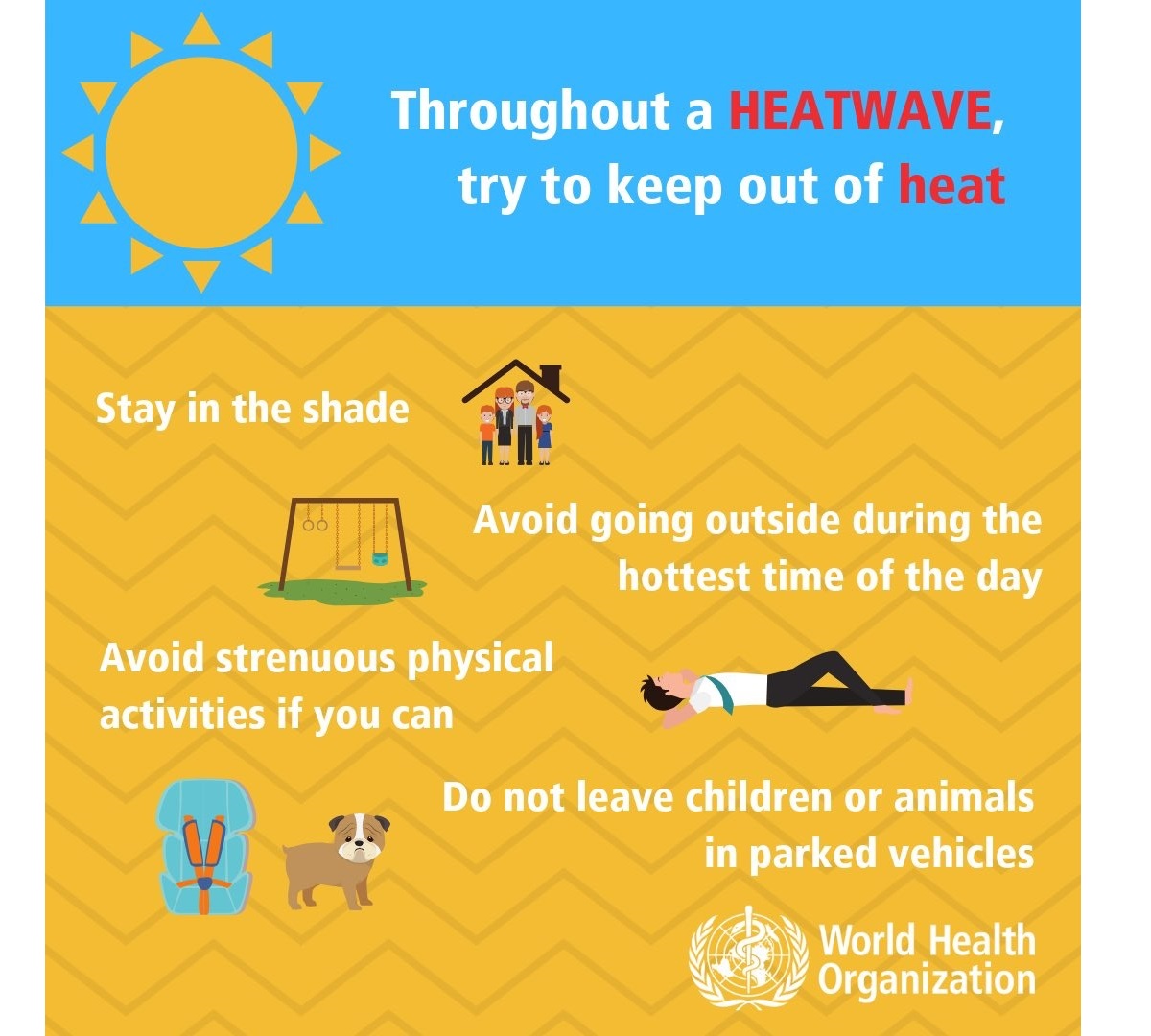
How to stay cool, hydrated, and healthy in scorching hot weather
Staying hydrated is one of the primary things during extreme heat. Consider taking these precautions and measures to stay healthy in scorching weather:
- Drink plenty of water! – the body cools through sweating; on a sweltering day, an adult may lose up to several liters of water. Keep drinking water, and avoid drinking alcohol, hot drinks, and drinks with high sugar content, as they can worsen dehydration. A regular intake of water is a good way of preventing dehydration.
- Keep cool – keep your body cool, stay out of the sun if possible. Eat small meals, preferably fruit and salads. Wear light-colored and loose clothing made from natural materials like cotton. Take a cool shower or a cold bath if you feel hot. Also – keep your workspace and living space cool. If you do not have air conditioning, shut the curtains and blinds during the day. Stay in the coolest room, and avoid using the stove and oven as much as possible. If your home gets too hot, go to a cooler place – a library, shopping center, cinema, or swimming pool.
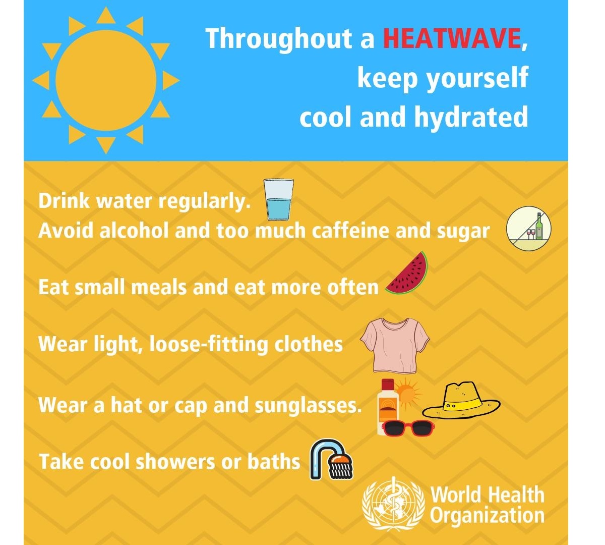
- Keep your food safe! – keep food that needs refrigeration adequately stored! Food spoils rapidly at high temperatures, and you may risk food poisoning if the food is not stored correctly.
- If you need to go out in the sun – protect your skin, use proper sunscreen and clothing to avoid sunburns. Cover your head correctly.
- Know your body, and have a plan – ask your doctor if you have any health conditions that may increase the risk of heat-related illness. Call and consult with your doctor if you are feeling unwell. Call emergency help (know the number!) if you feel unwell!
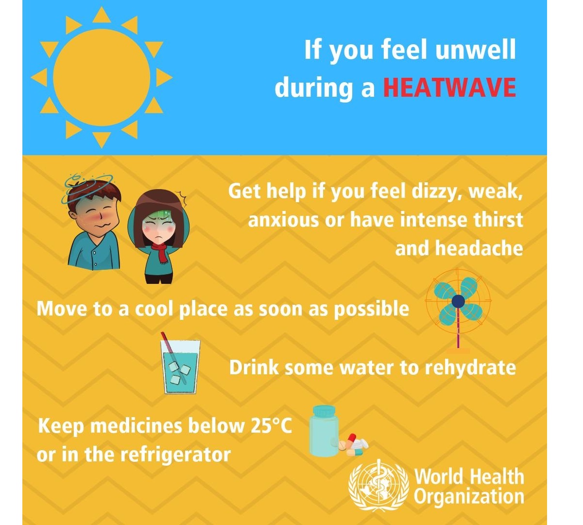
Common heat-related illnesses – symptoms and what to do if it happens
These symptoms’ descriptions and treatments below are informative only – consult with your doctor for details and professional advice:
Dehydration
Dehydration occurs when the body loses too much water to maintain normal functions. Symptoms include dizziness, tiredness, irritability, thirst, dark yellow urine, loss of appetite, and fainting. Drink plenty of water or diluted fruit juice. Avoid coffee, alcohol, and sugary drinks. Move to a cooler space to cool off. If you feel unwell, call your doctor or emergency room.
Heat rash
Heat rash is an itchy rash caused by excessive sweating. Move to a cooler, dryer environment, and keep the affected areas dry. Hydrating creams may make the condition worse. Consult with your doctor.
Heat cramps
This happens during strenuous activity when the body sweats and loses water and salt. Heat cramps manifest as muscle pains or spasms. If this happens, stop all activity, move/lie down in a cool place, and raise your legs slightly. Drink water or diluted juice. Have a cool shower or bath, and apply ice packs. Do not return to strenuous activity for several hours. If heat cramps do not subside, seek medical help.
Heat exhaustion
Heat exhaustion is the condition in response to losing excessive amounts of water and salt due to dehydration. Symptoms include heavy sweating, pale skin, fast and weak pulse, fast and shallow breathing, muscle weakness or cramps, tiredness and weakness, dizziness, headache, nausea or vomiting, and fainting.
If heat exhaustion occurs, the body needs to be cooled and rehydrated by moving to a chilled place, lying down, having a cool shower or bath, and placing cool packs under the armpits, groin, or back of the neck. Rehydration should be done by taking small amounts of cool fluids. Medical help is advised if symptoms do not abate within an hour.
Heat stroke
It happens when the body temperature reaches 40.5 °C and is a severe and life-threatening condition! Immediate first aid in lowering body temperature is critical, and an immediate call for an ambulance! Find more information on heatstroke here.
Stay safe!
Windy, Pivotalweather, and Meteociel provided images used in this article.
See also: