Typhoon Khanun has ravaged the Western Pacific region for almost two weeks. The storm has impacted various countries, including Taiwan and Japan, crossing the nation multiple times as it backtracked and changed direction. Finally, it appears on track to make its ultimate landfall in South Korea on Thursday. Meanwhile, a new Tropical Storm, Lan, has developed further east and will likely become a typhoon.
Typhoon Khanun has lasted as a powerful tropical cyclone for a lot longer than average for such storms (six to seven days), due to weak steering winds and the influence of prevailing mesoscale and synoptic scale weather conditions.
In its wake, the long-lived and slow-moving Typhoon Khanun has left behind a trail of damage, death, and widespread disruption, particularly on southern Japan’s Okinawa and Kagoshima Prefectures islands.

Widespread reports state two people were killed and 41 were injured as the Typhoon lashed the islands with relentless heavy rain and gusty winds. Meanwhile, about 166,000 households were without power, and the major airport servicing Naha, the Capital City of Okinawa, was shut down for two days during the storm.
TYPHOON KHANUN EXPECTED TO MAKE LANDFALL IN SOUTH KOREA ON THURSDAY MORNING
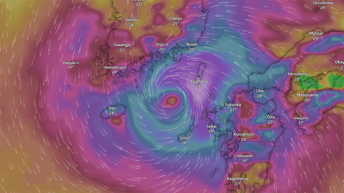
After a somewhat erratic path back and forth across the East China Sea and multiple tracks across the Japanese Okinawan islands in the past few weeks, the major forecast models are now in agreement that Typhoon Khanun will make landfall on the southern coastline of South Korea on Thursday morning.
The country is now bracing for the effects of Typhoon Khanun, the sixth typhoon in the Western Pacific region for the year so far. According to the Korea Meteorological Administration (KMA), Khanun is expected to bring heavy rainfall and strong winds to the southern coast starting today, Wednesday, and bring the entire country under its influence from Thursday to Friday when it could even pass through the Seoul metropolitan area.
On Tuesday afternoon, the local newspaper Korea JoongAng Daily reported that South Korean Authorities had raised the Disaster Warning Level one notch in a four-tier system to the highest “serious” level on Tuesday afternoon in response to the latest forecast track of the powerful storm.
The typhoon is expected to pass 30 kilometers west of South Korea’s Tongyeong in South Gyeongsang at around 9 a.m. on Thursday, making landfall on Korea’s southern coast and advancing in a northwest direction, the KMA said. If Khanun stays on course, its center may pass near or through the Seoul metropolitan area around 1 a.m. Friday, as shown in the video below.
The typhoon’s central atmospheric pressure is forecast to reach 970 hectopascals at 9 a.m. According to the KMA, Thursday has maximum wind speeds of up to 126km/h. Intense rainfall between 80 to 600 millimeters (3.1 to 23 inches) is forecast across the country on Thursday, while the central region could see continued rain through Friday morning. The impacts of that much rainfall on a hugely populated area such as Seoul, home to ten million people, could be disastrous.
PREPARATIONS ARE UNDERWAY IN SOUTH KOREA FOR THE IMPACTS OF TYPHOON KHANUN
As well as raising their Disaster Warning Level and Disaster Readiness Alert Level to their highest levels, the Korean authorities have commenced preparations for the inevitable impacts the typhoon will have when it makes landfall and continues to move northward across the country.
The preparations include a combination of planning and risk minimization, as well as the implementation of the Country’s Disaster Risk Reduction Strategy, which requires an immediate, coordinated response to disasters such as this typhoon.
Preparations for the Typhoon in South Korea have included:
- Evacuations of vulnerable coastal communities and up to 30,000 Scouts who had gathered in the region for the annual worldwide Scouts Jamboree
- Inspections of key industrial and energy facilities to prevent potential damage
- Activation of an emergency response system to immediately repair facilities in case of any damage and prevent further impacts and disruptions to essential systems such as power, transport, health services, and food supply
- ships and sailing vessels have been brought into port, and some removed from the water
As mentioned, preparations for the impact of Typhoon Khanun have included the evacuation from their campsite Tuesday of tens of thousands of youths from over 150 countries who had gathered in a very exposed location, with very little shelter at Saemangeum, North Jeolla, for the 25th World Scout Jamboree. Their forced evacuation comes after a recent heatwave and high humidity caused hundreds of young Scouts to fall ill.
HOW OFTEN DO TYPHOON STORMS IMPACT SOUTH KOREA?
Quite a few typhoons have made landfall in South Korea in recent years. Some notable storms include Typhoon Maemi in 2003, Typhoon Kompasu in 2010, Typhoon Bolaven in 2012, Typhoon Soudelor in 2015, Typhoon Chaba in 2016, and Typhoon Lingling in 2019. These typhoons brought varying degrees of impact, including heavy rain, strong winds, and flooding to different regions of South Korea. It seems that Typhoon Khanun will be added to the list.
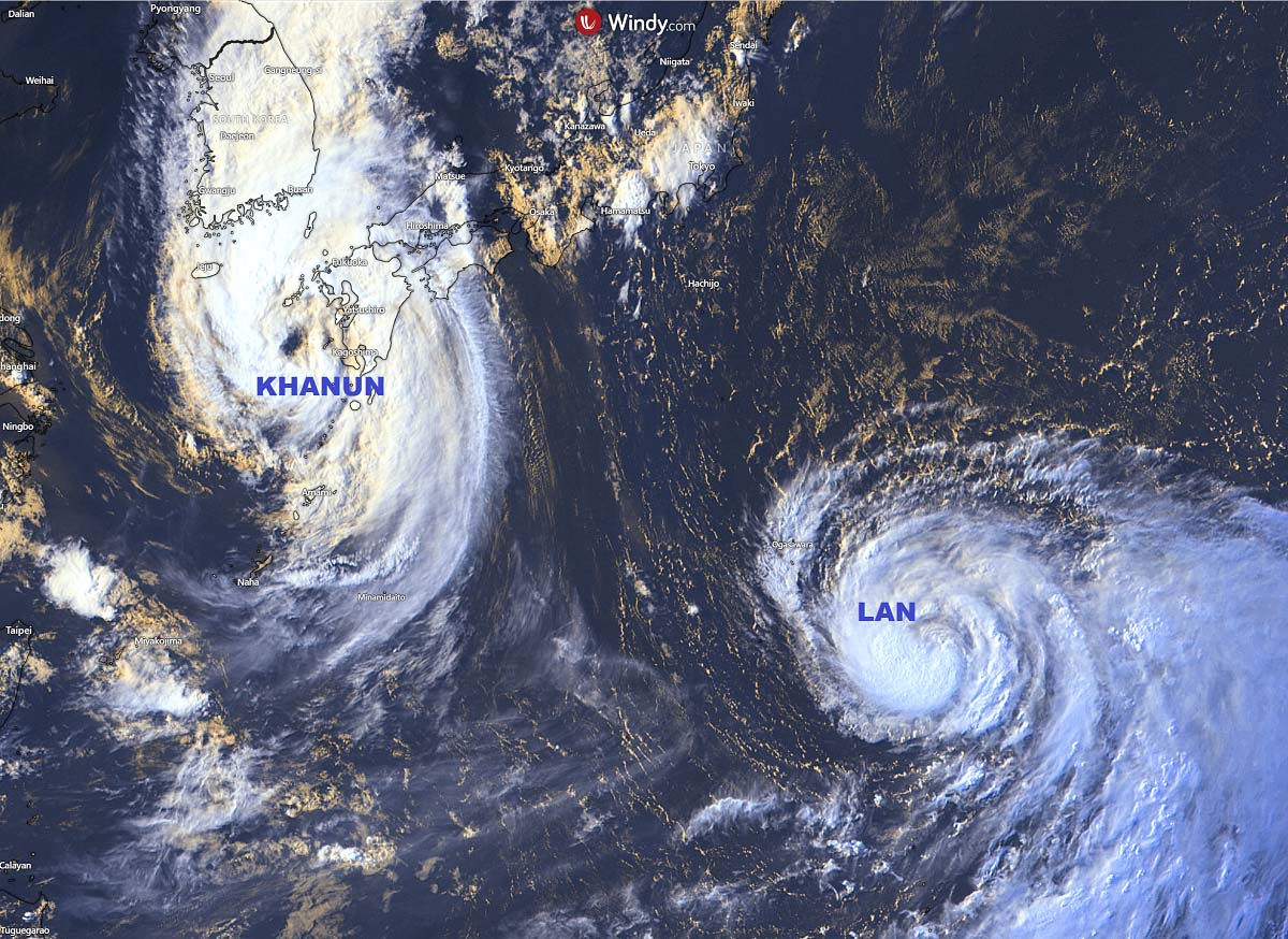
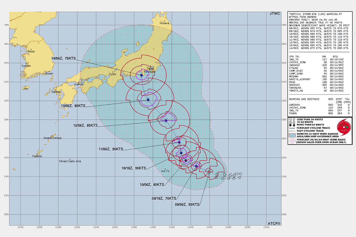
While slow-moving Typhoon Khanun makes its final approach toward landfall in South Korea, another Tropical Cyclone has developed in the region, as forecast models suggested. The new storm was upgraded from a Tropical Depression to a Tropical Storm on Tuesday and has since been named Tropical Storm (TS) Lan.
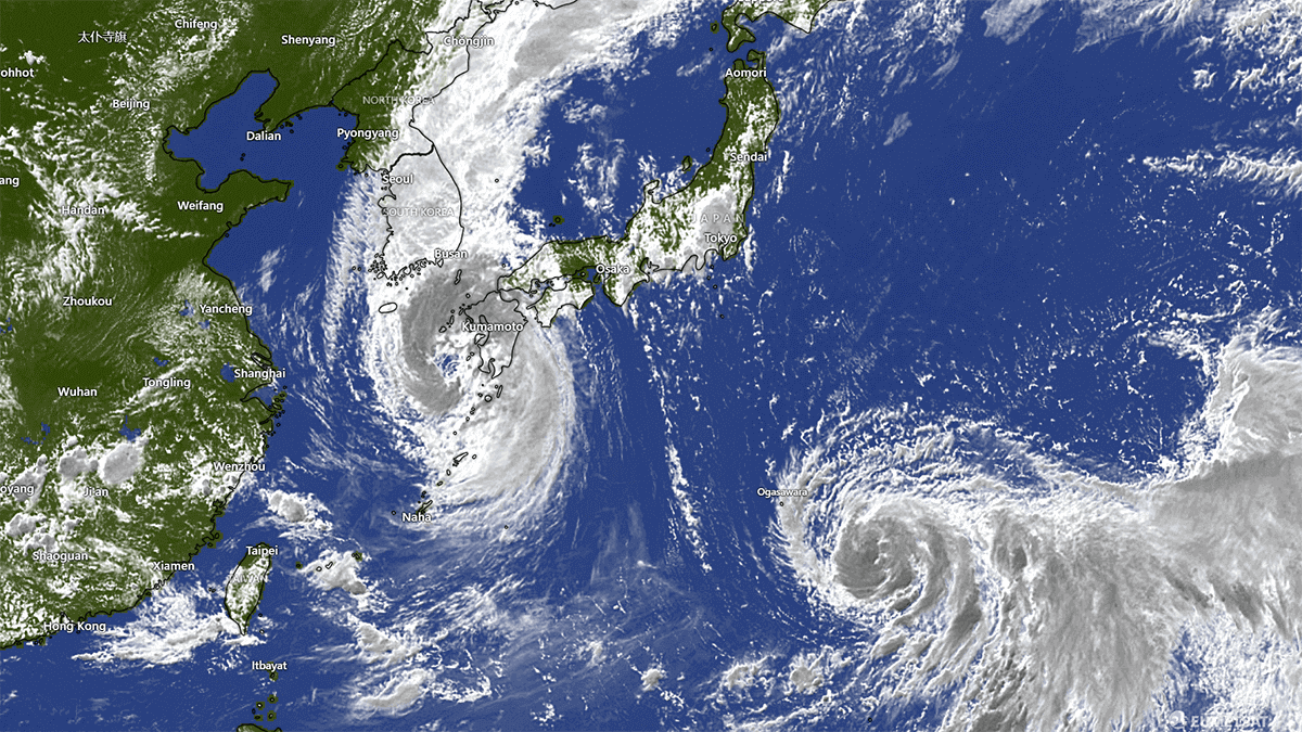
TS Lan is located some 1900km east of Typhoon Khanun and 1400km south of Tokyo, Japan. Lan produces sustained winds of approximately 55kts (102km/h), and wind gusts up to 70kts (130km/h). There is a good chance this storm will intensify and become a Typhoon this week.
COULD TWIN TYPHOONS IMPACT THE REGION AT THE SAME TIME?
We already have two Tropical Cyclones in the Western Pacific region. The mature and long-lived Khanun in its final stages, and Tropical Storm Lan in its early days as an organized storm.
Although the timing would have to be perfect, and both the storms would have to intensify over the next twelve hours, it is possible we could briefly see twin typhoons in the Western Pacific if Khanun intensifies again before making landfall in South Korea and Lan intensifies over the open tropical Pacific Ocean waters.
Twin typhoons, also known as twin cyclones, occur when two tropical cyclones develop and are active near each other. While they are relatively rare, they do happen from time to time. The frequency of twin typhoons can vary greatly from year to year and region.
In the Western Pacific region, where many typhoons form, twin typhoons are more likely to occur during the peak of the typhoon season, which we are entering right now, usually between July and October. However, twin typhoons are still relatively infrequent compared to the number of individual typhoons that form each year.
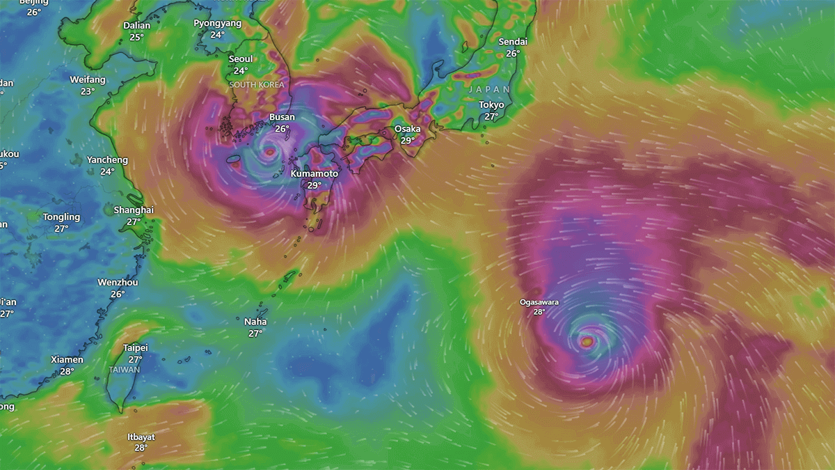
WHAT IS THE PROJECTED TRACK OF TROPICAL STORM LAN, AND COULD IT IMPACT TOKYO?
Obviously, it is very early in the development of Tropical Storm Lan, and the storm has yet to intensify to Typhoon status. However, the ingredients required for that intensification are in place and the forecast track and forecast intensity of the cyclone issued by the Joint Typhoon Warning Centre (JTWC) indicate Lan will become a Typhoon this week and likely move generally northwestwards towards the Tokyo region of mainland Japa as shown in the image below.
Sources & Credits:
Windy, JTWC, Korea JoongAng Daily
See also: